Kansas Geological Survey, Bulletin 32, originally published in 1940
Originally published in 1940 as Kansas Geological Survey Bulletin 32. This is, in general, the original text as published. The information has not been updated.
Coal ranks among the four most important mineral products of Kansas in value of yearly production. Although 95 percent of the coal produced in the state comes from beds in the Cherokee shale, which crop out in the southeastern-most counties of Kansas, there is a large quantity of coal in beds at higher stratigraphic levels that, can be mined if the price is sufficient. Post-Cherokee coal deposits are being mined in the Osage City, Pleasanton, Williamsburg, and Thayer districts; at several other localities farmers are obtaining coal by working on the outcrop.
The Kansas Geological Survey in 1937 published a bulletin on the geology and coal resources of southeastern Kansas (Pierce and Courtier, 1937). This report deals with coal beds in the Cherokee shale that are mined in Crawford, Cherokee, and Labette counties, but does not describe any other deposits of coal. The following report is intended to supplement that bulletin with a description of the coal deposits of post-Cherokee age that are being or have been mined in Kansas. The areal distribution of the post-Cherokee coal beds will be indicated and the methods by which they are being or have been mined will be described briefly.
The Osage City and the Williamsburg coal districts were examined by me during the first part of November, 1938. In July and August, 1939, other areas in which post-Cherokee coal beds are being mined or in which they have been worked were visited. These include areas in Atchison, Bourbon, Brown, Chautauqua, Cloud, Coffey, Douglas, Elk, Ellsworth, Jefferson, Leavenworth, Lincoln, Linn, Lyon, Montgomery, Neosho, Osage, Republic, Russell, Shawnee, Wabaunsee, Wilson, and Woodson counties. Wherever possible, the thickness of the coal was measured, its characteristics were noted, and the kind and thickness of the rock overlying and underlying the coal were recorded. Brief notes were made on the mining methods used.
The courtesy extended to me at all the places visited and the willingness with which questions were answered are much appreciated. Particular mention is made of the employees and operators of the Black Eagle coal mine at Carbondale, the Central Coal Company at Burlingame, the King mine at Arvonia, the Couch Coal Company at Williamsburg, the Dunbar coal mine near Thayer, the Square Deal coal mine near La Cygne, and the Mound City Coal Company at Mound City. Information about the mines near Fulton was obtained from Mr. Higgins of Fulton. Acknowledgments are made for information given by J. M. Jewett concerning the coal in Linn, Bourbon, and Labette counties and for assistance given by Norman Plummer in the study of the lignite beds in Ellsworth County. I have had access also to unpublished stratigraphic sections measured by R. C. Moore, N. D. Newell, and others, that are on file at the offices of the Kansas Geological Survey in Lawrence, Kan. The limestone outcrops shown on the county maps (figs. 11, 13, 14, 15, 16, 18, 19, 22, 23, 25, 26, and 28) have been taken from manuscript maps, which are also on file at the offices of the Kansas Geological Survey.
Several reports have been published concerning coal in Kansas, but for the most part these have dealt with the deposits in the Cherokee shale of Crawford, Cherokee, and Labette counties. A comprehensive report covering both the Cherokee and post-Cherokee coal deposits of Kansas was published by Haworth and Crane (1898). A report by Young and Allen (1925) repeats much of the material that was published by Haworth and Crane, but provides additional data with reference to the engineering and production methods in use and the chemical composition of the coals. Moore and Landes (1927) have discussed the post-Cherokee coal deposits in their report on the "Underground resources of Kansas." Moore (1929) describes briefly the geographic and geologic distribution of the most important coal beds of Kansas and gives analyses showing their chemical character. Wing (1930) describes the Cretaceous lignite that is being mined in Cloud and Republic counties. Other persons who have written concerning post-Cherokee coal beds are Saunders (1873), Knerr (1896), and Crane (1903). The annual reports of the Kansas coal mine and metal mine inspector give data on production and mines.
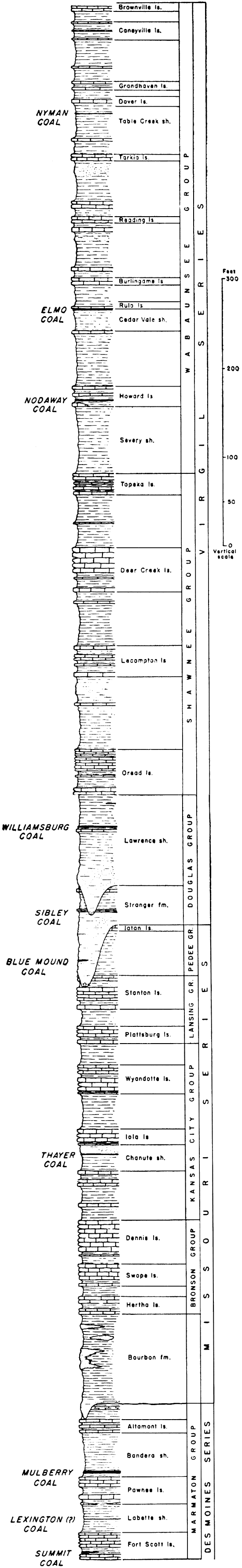
Figure 1--Generalized section of Pennsylvanian rocks of post-Cherokee age in Kansas showing the position of the principal coal beds.
It is not known just when or where coal was discovered first in Kansas, but it is probable that people began mining coal for their own consumption soon after the country was settled. Haworth (Haworth and Crane, 1898, p. 186) states that coal mining in the Pleasanton shale, the coal-bearing part of which is now classified as the Bandera shale (Moore, 1936, p. 63), was begun early in Kansas history. The coal was found near the surface and was easily mined by stripping.
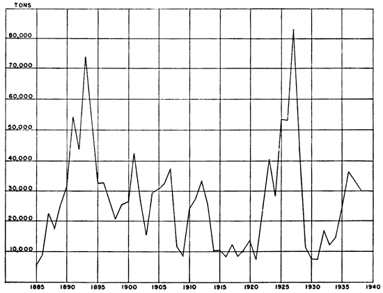
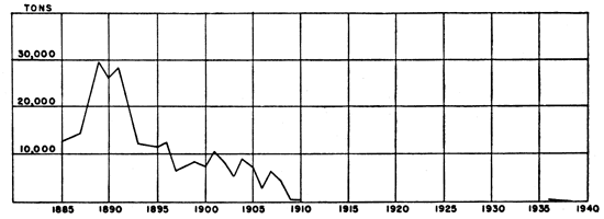
The production of coal began in the Pleasanton district about the same time as in the southern part of the state, some time between 1850 and 1860, but, the development of thicker coal in the Pittsburg area soon put a stop to work at Pleasanton. Considerable interest was shown in the district in 1903 and 1904, according to C. M. Young (Young and Allen, 1925, p. 45). The mines were not very successful, however, and work was nearly abandoned from 1908 to 1910. A revival of the coal-mining industry in Linn County lasted from 1922 to 1928. According to reports of the state coal mine inspector, the annual production of this county reached 83,218 tons in 1927, but declined to less than 8,000 tons in 1930. Production has been increasing in recent years, and in 1938 it amounted to 30,295 tons. The accompanying graph (fig. 2) shows the tonnage of coal produced in Linn County from 1885 to 1938.
Figure 2--Coal production, Linn County, Kansas. Compiled from reports of the Kansas state mine inspector, supplemented by statistical reports of the U. S. Geol. Survey and the U. S. Bureau of Mines.
Very little information is available concerning the development of coal in Neosho County. It is likely that the early settlers in the vicinity of Thayer mined coal for domestic consumption from the coal bed cropping out there, as was done in the districts to the east. At any rate, Haworth (Haworth and Crane, 1898, p. 133) states that by 1898 a large amount of coal for local consumption was produced from mines near Thayer. The coal was hauled to Neodesha and other neighboring towns. Coal has been mined in that vicinity on a small scale almost continuously to the present time. The Thayer district produced 2,972 tons of coal in 1938.
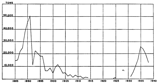
Figure 3--Coal production, Williamsburg district. Compiled from reports of the Kansas state mine inspector, supplemented by statistical reports of the
About 1878, according to Haworth's account, many farmers supplied themselves with fuel from coal mines south and southeast of Lawrence. Most of the mines were south of Wakarusa river, and 5 to 8 miles southeast and south of town. The coal generally was mined by stripping where the coal cropped out around the borders of the hills, but in a few places it was worked by shaft mining. Three shaft mines were being operated at Sibleyville about 1889. Some of this coal was sold in Lawrence and some to farmers who came to the mines. Haworth (1895, p. 303) states that the Douglas County mines were almost entirely abandoned by 1892. A mine near Blue Mound, a hill approximately 5 miles southeast of Lawrence, was in operation in 1934, producing 200 tons of coal during that year (annual report of the state coal mine inspector).
Coal was mined along Salt creek in the vicinity of Leavenworth as early as 1854, and in 1861 a coal bed was worked along Little Stranger creek, about 5 miles west of Lansing, according to Haworth (Haworth and Crane, 1898, p. 188). Hinds and Greene (1917, p. 11) mention that 10,000 tons of coal was mined in 1867 from a bed exposed along Little Stranger creek below Boling, not far from the southwest corner of the Leavenworth quadrangle. The mining at these two places was abandoned after a few years. Mining of post-Cherokee coal in Leavenworth County has been renewed in recent years. One mine 6 miles east of Tonganoxie was operated in 1938 and 1939.
Coal mining at Atchison in beds of post-Cherokee age began in the summer of 1893 when coal was discovered in a narrow ravine leading to Missouri river about 2 miles south of Atchison (Haworth and Crane, 1898, p. 188). The discovery was made by a colored man named O'Connell, who drifted-out a wagonload and hauled it to Atchison for sale. In 1897, two mines, one operated by a Mr. Challis and the other by the Donald brothers, produced about 5,000 tons of coal. Both mines had been abandoned, however, by April, 1904. Landes (1937, p. 7) reports that two small coal mines operated in Atchison County during 1935, mining the coal that crops out along the bluffs and in ravines adjacent to Missouri river. No mines were operated in this county in 1938.
The Osage City coal district has been the most important coal-producing area.in Kansas outside of the southeastern Kansas field. Coal was discovered in the district in the spring of 1869 by John F. Dodds, who was digging a well at a point known as Carbon Hill, two miles east of Carbondale. The discovery was followed immediately by the development of mines on Carbon Hill and in that vicinity. In the fall of 1869 mines were opened at Osage City by Godfrey and Price of Hannibal, Mo., who named their company the Carbon Coal and Mining Company of Missouri. A year or two later, T. J. Peter bought the company from Godfrey and Price and continued operations under the name of the Carbon Coal and Mining Company of Kansas. Mines were opened at Scranton in 1874 by O. H. Sheldon, who began operating strip pits. Later he began shaft mining. Mining did not begin at Burlingame until 1878 or 1879. The coal at Burlingame is deeper than to the east around Carbondale and Scranton, or to the south where it was mined east of Osage City, and many people thought that the coal did not exist near Burlingame.
In 1880 the Santa Fe Railroad bought a half interest in the Carbon Coal and Mining Company at Osage City. A year or two later it bought the remaining interest and increased the holdings of the company to about 30,000 acres. This company became the principal coal-mining company in the district., supplying virtually the whole Santa Fe system with coal for all points east of Colorado until the railroad opened its mines in Crawford County.
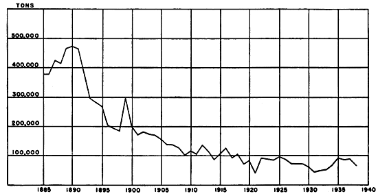
The output of the district. reached its peak in 1889, according to Young (Young and Allen, 1925, pp. 54, 56-57), when 445,000 tons of coal was produced. Since 1889, production has decreased steadily and considerably. Production in 1931 had declined to 45,909 tons (annual reports of the state coal mine inspector). There was a marked increase in activity from 1932 to 1937, however, the annual output exceeding 90,000 tons in 1937. Production dropped to 68,,038 tons in 1938, owing to a mild winter season. The annual production of the Osage City district from 1885 to 1938 is shown in figure 4.Figure 4--Coal production, Osage City district. Includes production figures for Coffey and Lyon counties. Compiled from reports of the Kansas state mine inspector. supplemented by statistical reports of the U. S. Geol. Survey and the U. S. Bureau of Mines.
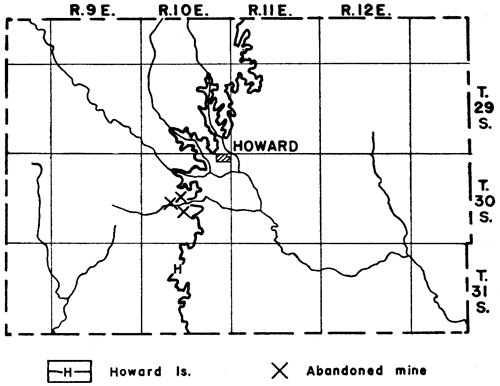
Haworth states that in 1898 a line of mines, irregularly connected, reached from the Osage City field northward along the line of outcrop of the coal, by way of Topeka, into northwestern Jefferson, western Atchison, and eastern Brown counties, and that south of the Osage City field, mining had been prosecuted all the way from Lebo south to the state line by way of Madison, Eureka, Howard, and Leeds. Throughout this line of outcrop someone occasionally opens a strip pit or a shaft to mine coal to sell for local use.
The production of coal from the lignite beds in the Dakota group began in Cloud and Republic counties at Minersville, 6 miles north of Concordia, as early as 1855 (Wing, 1930, pp. 43, 44). By 1887, Cretaceous coal was being mined in Ellsworth, Lincoln, Cloud, Republic, and Jewell counties, and in 1890 production was reported for Mitchell and Russell counties also. Mining of Cretaceous coal has continued until relatively recent times, when cheaper transportation brought competition from eastern Kansas. At no time, however, has the output been large. The peak of production for the district around Minersville was reached in 1894 and 1895, when at least eight companies were operating in the field. The production for Republic county in 1894, quoted by Wing, was 8,242 tons and that for Cloud county in 1895 was 5,000 tons. The report of the state coal mine inspector for 1936 mentions a small production from Cloud county and that. for 1937 a very small production from both Cloud and Republic counties. One mine operating in Cloud county during 1938 produced 50 tons of coal. Figure 5 shows the annual production of Cretaceous coal from 1885 to 1938.
Figure 5--Cretaceous coal production, Cloud, Ellsworth, Jewell, Lincoln, Mitchell, Republic, and Russell counties. Compiled from reports of the Kansas state mine inspector, supplemented by statistical reports of the U. S. Geol. Survey and the U. S. Bureau of Mines.
Moore (1936), in his stratigraphic classification of Pennsylvanian rocks in Kansas, mentions twenty-six coal beds lying above the Cherokee shale. These range from very thin beds to one that, locally attains a thickness of 42 inches. At least ten of these beds have been mined in different areas in Kansas. Figure 1 shows the position of these coal beds in the stratigraphic column. Of the ten beds, the Mulberry coal in the Bandera shale, the Williamsburg coal in the Lawrence shale, and the Nodaway coal at the top of the Severy shale are mined the most extensively. None of the post- Cherokee beds in Kansas, however, have been developed to the same extent as those in the Cherokee shale.
Several lignite beds of Cretaceous age are found near the top of the Dakota formation in central and north-central Kansas, some of which are mined from time to time for local consumption.
The coal beds that are discussed in this report are (1) the Summit coal,; (2) the Lexington coal; (3) the Mullberry coal; (4) the Thayer coal; (5) the Blue Mound and Sibley coals; (6) the Williamsburg coal; (7) the Nodaway coal; (8) the Elmo coal; (9.) the Nyman coal; and (10) the Cretaceous coals.
The Summit coal locally overlies the lower limestone member of the Fort Scott limestone in northeastern Bourbon County, where it ranges from less than 1 inch to 2 feet in thickness, and in Vernon county, Missouri. No coal is found in this interval at Fort Scott, however, nor farther south in Crawford and Labette counties. About 5 to 6 feet of black slaty shale, containing large pyritic concretions, overlies the coal and is overlain by the upper limestone member of the Fort Scott limestone.
The Summit coal is mined Along tributaries of Little Osage river in northeastern Bourbon County, 3 to 4 miles east and 4 miles north of Hammond.
The name Lexington coal has been applied by Missouri geologists to a coal outcropping near Lexington, Mo. This coal lies near the top of the Labette shale and is the first commercial coal in Missouri above the Fort Scott limestone. It is overlain by the so-called "Lexington cap-rock", a thin limestone that Moore and Jewett (personal communication) have found to be the lowest limestone member of the Pawnee formation.
In Kansas, a coal bed near the middle of the Labette shale has been called the "Lexington" coal, but it is not the same coal bed as that in Missouri. A thin, discontinuous coal bed just below the Pawnee limestone in parts of Labette County, however, is the southern extension of the Lexington coal of Missouri and is the true Lexington coal bed. The true Lexington coal bed where it has been seen in Kansas is only 1 to 2 inches thick and is not mined.
The coal bed near the middle of the Labette shale averages approximately 8 inches in thickness. It is overlain by at least 6 feet of thin-bedded shaly sandstone along the banks of Lightning creek west of Girard. Under the coal at that place is 16 inches of underclay containing considerable carbonaceous material. Beneath the underclay is a hard blue shale. This coal bed is not mined either.
The Mulberry coal, named from Mulberry creek in Bates County, Missouri (Hinds, 1912, p. 75), occurs in the lower part of the Bandera shale, only about 3.5 feet above the Pawnee limestone. It ranges in thickness from 5 inches in the southern part of Bourbon County to 42 inches at La Cygne in northern Linn County. The average thickness in Linn County and northern Bourbon County is 26 inches. This coal seemingly thins and disappears to the south, as no coal is reported at this horizon south of Bourbon County. Its western and northern extent is not known. It is found as far west as Mapleton in Bourbon County and Manty and Mound City in Linn County, where the thickness is 20, 23, and 18 inches, respectively, but how much farther west it extends is not known.
Young (Young and Allen, 1925, p. 33) reports that to the north "records of drilling show coal at Fontana, which is near the south side of Miami County, about six miles northwest of La Cygne. None of the four beds which have been reported have been exploited, and the idea of their existence is based on the rather uncertain evidence of bore holes sunk with churn drills." In Missouri (Greene, 1933, p. 18), the Mulberry coal persists to northern Bates County and occasionally has been logged much farther north.
A persistent pyrite seam, or rather a layer of flat pyrite nodules or concretions, lies 15 to 18 inches above the base of the coal. The concretions average approximately 1 inch thick and few are more than 1.5 inches thick.
The rock between the Pawnee limestone and the coal consists of a blue-gray shale, which grades upward into an underclay just under the coal. The underclay contains carbonaceous remains of plant fragments. The Bandera shale above the coal is a blue-gray, somewhat sandy shale. The total thickness of the Bandera shale is 50 to 60 feet.
The Mulberry coal has been mined by stripping operations near Fulton, Prescott, Manty, and Mound City. Shaft mining has been used near Mapleton, and in the territory around Pleasanton, Boicourt, and La Cygne. The most important operations in 1939 were, those east and northeast of Prescott, east and northeast of Pleasanton, east and southeast of La Cygne, and at Mound City. The area covered by the more important mining operations in this coal bed is called the Pleasanton coal district, or sometimes it is termed the Linn County coal district.
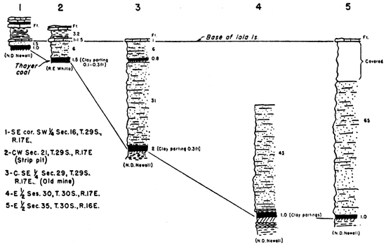
The Thayer coal lies in the upper part of the Chanute shale. It is a persistent bed extending from Miami County in the north to Montgomery County in the south. A thin bed of coal is found locally at this horizon in Wyandotte County. The coal ranges in thickness from 4 inches in Miami County to about 26 inches in eastern Wilson County, west of Thayer. South of Wilson County, in the vicinity of Independence, it measures about 1.0 inches. A clay seam 0.5 to 4 inches thick lies 5 to 9 inches below the top of the coal in the vicinity of Thayer and southward.
That part of the Chanute shale above the coal is a thin-bedded to massive sandstone that is known as the Cottage Grove sandstone (Moore, 1936, p. 110). Channels filled with sandstone locally have cut into the coal and it is possible that they may have cut completely through it in some places. The thickness of the Cottage Grove sandstone is not uniform. Where the formation is thin, the Thayer coal is nearer the top of the Chanute shale and the overlying Iola limestone than where it is thick. Thus, according to unpublished work of N. D. Newell, the Thayer coal is found 18 inches to 65 feet below the Iola limestone, according to variation in the thickness of the Cottage Grove beds above the coal (fig. 6).
Figure 6--Stratigraphic sections in southeastern Wilson County showing position of Thayer coal below Iola limestone.
The Chanute shale below the coal is predominantly a blue-gray shale overlain by a few inches to 2.5 feet of underclay that lies directly beneath the coal. Some sandy shale and sandstone occurs in the lower part of the Chanute shale section and locally there is very calcareous shale containing limestone nodules. The total thickness of the Chanute shale ranges from about 10 feet at some places near Kansas City to 100 feet or more in southern Kansas.
Several thin coal beds occur locally above the Thayer coal in the Cottage Grove sandstone where there is an abrupt thickening of the sandstone west and southwest of Thayer. Most of these beds are 1 inch to 6 inches thick. One bed, in secs. 29 and 32, T. 29 S., R. 17 E., in eastern Wilson County, is 10 to 17 inches thick. It lies 6 to 10 feet below the Iola limestone and 30 to 40 feet above the Thayer coal bed. It disappears to the north within a distance of 1 mile and to the east within 1.5 miles.
The Thayer coal has been mined locally in the vicinity of Blue Mound in Linn County and west and southwest of Thayer in Neosho and Wilson counties. At least one of the coal beds found locally southwest of Thayer in the Cottage Grove sandstone above the Thayer coal has been mined also.
Several thin coal beds present in the Tonganoxie sandstone member of the Stranger formation in the vicinity of Kansas and Missouri rivers disappear to the southward (Moore, 1936, p. 148). Most of them are 6 inches or less in thickness, but locally some are more than 12 inches thick.
At least three coal beds are present in the Tonganoxie sandstone in the Blue Mound area between Lawrence and Vinland in Douglas County. The lowest of these, here designated as the Blue Mound coal, is about 55 feet below the top of the Tonganoxie sandstone and ranges in thickness from 12 to 14 inches. This bed has been mined about 5 miles southeast of Lawrence near the hill called Blue Mound, and at Sibleyville, 1 mile south of Blue Mound. Surface outcrops of this bed were not seen by me. The other two coal beds are thin, measuring 6.5 and 3 inches, respectively, the one being approximately 37 feet and the other 55 feet above the lower bed.
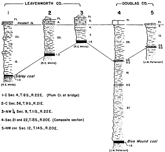
The Sibley coal at the top of the Tonganoxie sandstone is the most extensive of the coal beds in the member. It is traceable from the vicinity of Baldwin northeastward to Iatan, Mo., but it is absent at St. Joseph, Mo. Southward, the extent of the bed has not been determined. The coal is thin, averaging about 4 inches in thickness, but locally in an area 6 miles east to 12 miles northeast of Tonganoxie it is 18 to 20 inches thick. North of Leavenworth where it outcrops along Plum creek it ranges from 12 to 14 inches in thickness. The changes in thickness and the position of the Sibley coal with respect to the Haskell limestone are shown in figure 7. The Sibley coal is mined 6 miles east of Tonganoxie.
Figure 7--Stratigraphic sections showing Sibley coal in parts of Leavenworth and Douglas counties.
The Tonganoxie sandstone comprises thick masses of cross-bedded channel sandstone and sandy shale. The sandy shale that is interbedded with the sandstone beds locally contains plant fragments but no marine fossils. The thickness of the Tonganoxie sandstone is extremely variable, ranging from 3 or 4 feet near Elk City to nearly 100 feet in eastern Leavenworth County.
The Williamsburg coal, formerly called the Ransomville coal (Moore, 1929, pp. 5, 7), lies in the Lawrence shale 30 to 55 feet below the Oread limestone formation. It ranges in thickness from a few inches in parts of Douglas County to 20 inches near Williamsburg in Franklin County. The thickness of the coal in Franklin County ranges from 12 to 20 inches, and averages 16 inches. The coal thins to the north in Douglas County. In the vicinity of Lone Star State Lake about 15 miles southwest of Lawrence, there is 6 inches of coal overlain by 14 inches of black carbonaceous shale containing thin streaks of coal. An unpublished composite section between Vinland and Baldwin prepared by J. M. Patterson shows 2 to 11 inches of coal at this horizon.
Locally in the vicinity of Lone Star State Lake in Douglas County a coal bed measuring 8 inches in thickness lies above the Williamsburg coal and only 10 feet below the Oread limestone.
A coal bed occupying about the same place stratigraphic ally in the Lawrence shale as the Williamsburg coal crops out along the bluffs and ravines tributary to Missouri river south of Atchison. This bed measures about 16 inches in thickness.
A coal bed 1 to 17 feet below the Oread limestone crops out in northwestern Anderson and eastern Coffey counties and in Woodson County. This bed is regarded by some persons as the southern extension of the Williamsburg coal. The interval between the coal and the overlying limestone is thinnest in Woodson County and increases in thickness northward. The thickness of the coal range,-, from 10 to 12 inches. The position of the Williamsburg coal below the Oread limestone and that of the coal bed in Coffey and Woodson counties is shown by means of stratigraphic sections in figure 8.
Figure 8--Stratigraphic sections of upper part of Lawrence shale showing position of Williamsburg coal below Oread limestone.
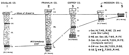
An almost unfossiliferous limestone, approximately 20 to 24 inches thick, underlies the coal at Williamsburg. According to Moore (1936, p. 157), this may represent the Amazonia limestone, which lies 25 to 60 feet below the Oread formation and seems to lie 15 or.20 feet below the coal in northwestern Missouri. The Amazonia limestone is absent from Atchison southward to Williamsburg. Unpublished stratigraphic sections by Newell in northwestern Anderson and eastern Coffey counties and in Woodson County show a limestone that ranges in thickness from 10 inches to 4 feet at a distance of 7 to 15 feet below the coal in these counties.
The Williamsburg coal is mined in southwestern Franklin County in the vicinity of Williamsburg and in southeastern Osage County near Quenemo. The coal has been mined, also, about 2 miles south of Atchison. Locally farmers have taken coal from the outcrop for use as domestic fuel.
The Nodaway coal is a very persistent coal, which generally is regarded as occurring at the top of the Severy shale. Actually it is in the Aarde shale member of the Howard limestone. The lower member of the Howard limestone, the Bachelor Creek limestone, is absent north of Greenwood County, however, and the Nodaway coal and other beds that are stratigraphic ally equivalent to the Aarde shale are classed as belonging to the top of the Severy shale. As Moore (1936, p. 206) explains, it is not practicable to draw a boundary between two shale bodies where the Bachelor Creek limestone is absent. In Greenwood County and farther south the coal lies above the Bachelor Creek limestone in the Aarde shale.
The coal crops out along a northeast-southwest line from Doniphan County through western Atchison, northwestern Jefferson, Shawnee, Osage, northwestern Coffey, Greenwood, Elk, and Chautauqua counties. It ranges in thickness from 1 inch in Greenwood County to a reported maximum of 30 inches in Osage County. The average thickness in Osage County is 15 inches. The maximum thickness of the coal north of Osage County is 12 inches. South of Greenwood County the coal thickens to 18 inches in Chautauqua County.
The bed next above the coal and below the Church member of the Howard limestone consists of shale, which in places is blue-gray and almost massive, but which in other places contains black platy shale. Its thickness ranges from 19 inches to 10 feet, thickest portions being those near Carbondale in Osage County and near Leeds in Chautauqua County.
Above this shale bed is the Church limestone member of the Howard formation. It is a persistent and easily recognized bed forming a convenient guide in tracing the Nodaway coal. The color of the unweathered limestone is dark blue to blue gray. On weathered surfaces, however, it has a drab to yellowish-brown color. The rock is very hard, dense, and brittle. It commonly consists of a single massive bed, but locally there are two or more even layers (Moore, 1936, p. 207). Its thickness ranges from 1.5 to 6 feet, the average being slightly more than 2 feet.
Because of its position above the Nodaway coal, the Church limestone acts as a protective cap rock so that the coal is affected very little by weathering even where it is only a short distance below the surface. On the other hand, it must be blasted to be removed in stripping operations.
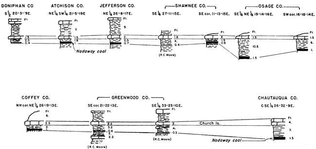
Stratigraphic sections to indicate the thickness of the Nodaway coal and its position below the Church limestone are shown in figure 9.
Figure 9--Stratigraphic sections showing position and thickness of Nodaway coal.
At some places beneath the coal there is a distinct underclay, consisting of structureless sticky clay, but in other places a well-stratified shale underlies the coal.
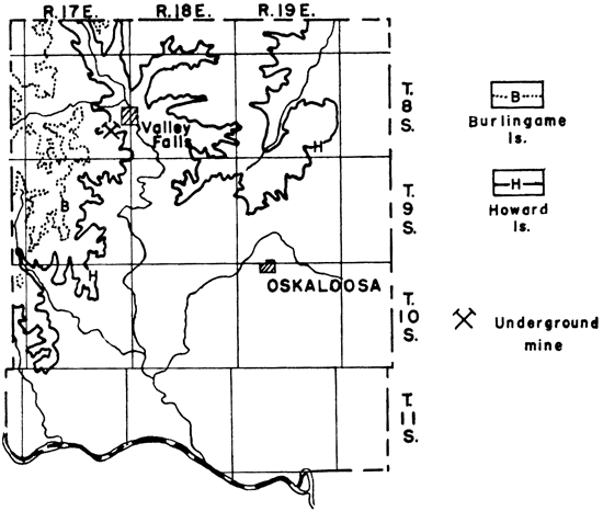
The Nodaway coal is mined in Osage and Coffey counties near Carbondale, Scranton, Burlingame, Osage City, Arvonia, and Lebo. Some mining also is being done near Valley Falls in Jefferson County and at Leeds in Chautauqua County. In addition, the coal has been mined near Huron in Atchison County, at Topeka in Shawnee County, east of Neosho Rapids in Coffey County, and west of Howard in Elk County.
The Elmo coal is a persistent coal that is found 20 to 30 feet below the Burlingame limestone in the Cedar Vale shale, just below the Rulo limestone. Its outcrop in Kansas extends from northeastern Brown County to southwestern Chautauqua County and it continues beyond the state boundaries to the north and south. At places where it is exposed north of Kansas river it is 10 to 14 inches thick.
The interval between the coal and the Rulo limestone varies. In northeastern Brown County near the Nebraska line the limestone rests on the coal. Farther south in Jefferson County there is 12 feet of blue-gray shale between the coal and the limestone above it. That part of the Cedar Vale shale below the coal is a blue-gray to yellowish-brown shale containing clayey and sandy beds in some places. The average thickness of the Cedar Vale shale, according to Moore (1936, p. 212), is 25 feet.
The Elmo coal has been mined on a small scale in Brown County near Robinson and White Cloud and in Shawnee County near Silver Lake. It is probably the coal that Haworth (Haworth and Crane, 189S, p. 137) mentions as being mined about 8 miles west of Topeka.
The Nyman coal is a persistent, thin coal bed near the top of the Table Creek shale only a short distance below the Dover limestone (Moore, 1936, p. 234). It extends almost uninterruptedly across southeastern Nebraska and northern Kansas and is recognized locally in southern Kansas. In Wabaunsee County the coal is 7 to 8 inches thick and lies about 11 feet below the Dover limestone. The interval between the coal and the Dover limestone consists of a somewhat sandy shale containing locally a thin limestone 2 to 6 inches above the coal. The total thickness of the Table Creek shale ranges from 5 feet at Emporia to 50 feet or more in Wabaunsee County.
The Nyman coal has been worked locally in Wabaunsee County near Dover, and, according to Moore and Landes (1927, p. 49), it was mined in Nemaha County in the early days before rail transportation made other fuel readily available. A 16-inch bed of coal that was mined a few years ago near Admire in Lyon County (according to the report of the state coal mine inspector, 1934), may be the Nyman coal.
Several coal beds of the lignite type, which is characterized by relatively large content of volatile material, have been found near the top of the Dakota group. These occur just below the Graneros shale in Russell, Ellsworth, Lincoln, Mitchell, Jewell, Cloud, and Republic counties. Almost all are within the upper 20 feet of the formation (fig. 10). Individual lignite beds range from a few inches to 3.5 feet in thickness, but are generally very local in occurrence, grading laterally into lignitic or carbonaceous shales and clays. The lignitic zone, however, is very persistent.
Figure 10--Generalized section of the upper 75 feet of Dakota group in Kansas showing lignite horizons. Drawn from data given by Norman Plummer.
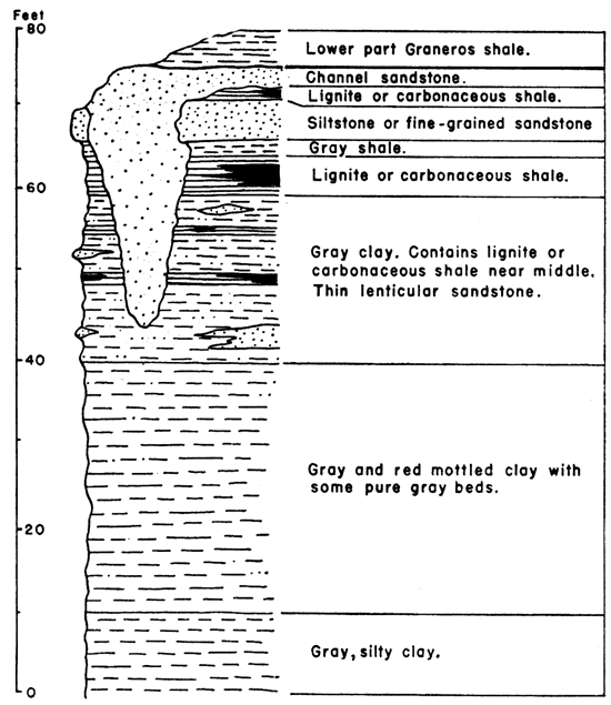
That part of the Dakota containing the lignite beds consists of clays, shales, and sandstones. According to Plummer (personal communication), a fine-grained sandstone, or siltstone, 1 to 10 feet thick occurs at or near the top of the Dakota group. Lignite in some places lies on top of this sandstone or in a shale a short distance above it. At other places the lignite is contained in a clay or shale and lies as much as 20 feet below this sandstone.
The principal place where Cretaceous coal has been mined is Minersville on the Cloud-Republic county line, about 6 miles north of Concordia. Other places where it has been mined are in Jewell County, 3 miles east of Jewell; in southeastern Mitchell County near Saltville; in Lincoln County near Denmark, northwest. of Denmark along Spillman creek, and south of Lincoln near the Lincoln-Ellsworth county line; in Ellsworth County about 9 miles northeast of Kanopolis and 2.5 miles southwest of Wilson; and in Russell County, north of Dorrance, northeast of Bunker Hill, and in the southeastern part. of the county along Coal creek.
Coal in the Lawrence shale at the horizon of the Williamsburg bed crops out across the northwestern corner of Anderson County. It lies 12 to 17 feet below the Oread limestone. According to stratigraphic sections made by Newell, the coal is a shaly coal 1 to 1.5 feet thick. It is overlain by a somewhat sandy shale and underlain by underclay, which grades downward into a clayey shale. Lying 7 to 10 feet below the coal is a brown, nodular limestone 10 inches thick.
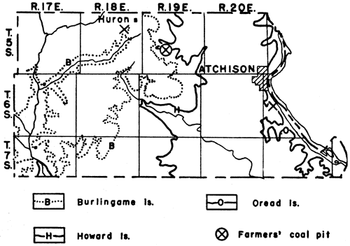
Figure 11--Map of Atchison County showing outcrops of Oread, Howard, and Burlingame limestones.
The coal in the Lawrence shale crops out along the bluffs and in the ravines tributary to Missouri river. Along most of the outcrop, however, it is concealed by a covering of soil, or slump, and is exposed only where it has been uncovered by streams flowing across it. The coal is 10 to 16 inches thick and is underlain and overlain by shale.
This coal was mined from 1893 until 1904 by at least three companies, whose mines were located along the Missouri Pacific Railroad 2 to 3 miles south of Atchison. These mines were either drift or slope openings and used the longwall system of mining (reports of the state coal mine inspector). Both hand labor and electric mining machines were used. The coal was sold in Atchison on the local market.
The Nodaway coal crops out at several places from north to south across the center of the county. It is 19 to 24 inches below the Howard limestone and is 7 to 12 inches thick. Plate 1B shows an exposure of the Nodaway coal in the bed of a small creek near Huron. The rock between the coal and the overlying limestone consists of gray to black shale, including 3.5 to 8 inches of black fissile shale 1.5 to 6 inches above the coal. The coal is underlain by 6 feet of blue-gray shale, which in turn is underlain by a thin-bedded blue-gray sandstone or sandy shale.
Plate 1--A, The Curtis mine on the Cloud-Republic county line, about 6 miles north of Concordia in the NE sec. 2, T. 5 S., R. 3 W.; B, The Nodaway coal exposed in the bed of a small creek 3 miles east and 2.5 miles south of Huron in the SW sec. 21, T. 5 S., R. 19 E.
The Nodaway coal has been mined locally east and southeast of Huron and sold to the people in that vicinity. Some of the farmers on whose land the coal crops out are mining coal for their own use.
The Elmo coal in the Cedar Vale shale, a short, distance below the Burlingame limestone, crops out in the western and northwestern parts of the county. Near Muscotah and Arrington the coal is 10 to 12 inches thick and is overlain by 12 feet of shale. A limestone occurs at the top of the shale. Shale also underlies the coal. Coal that may have been the Elmo coal was mined years ago 2.5 miles southwest of Huron. The mines have long been filled in, however. The Elmo coal is reported to be mined occasionally near Arrington and Larkinburg.
Beds of post-Cherokee coal are found at two stratigraphic horizons in Bourbon County. The lower one of these is the Summit coal in the Fort Scott limestone and the upper one the Mulberry coal in the Bandera shale. The outcrops of these two coal beds are shown on a map of Bourbon County in figure 12.
Figure 12--Outcrops of Mulberry and Summit coal beds in Bourbon County.
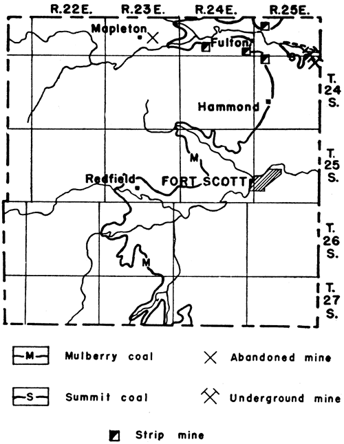
The Summit coal is found only in northeastern Bourbon County, cropping out along the tributaries of Little Osage river. It ranges from a thin sheet to 2 feet in thickness and is mined locally in a small area 3 to 4 miles east and 3.5 to 4 miles north of Hammond. The mines are all drift mines, opening from the sides of old strip pits around the sides of the hills. Mining is done by hand, no machines being used. The coal is overlain by 5 feet of black platy shale containing large concretions, some of which are as much as 2 feet in diameter. A thick, massive limestone, which is the cap rock of the hills in the area, overlies the shale.
The Mulberry coal lies approximately 3 feet above the Pawnee limestone, cropping out along an irregular line from the vicinity of Fulton southward across the center of the county. The outcrop in most places, however, is concealed by a covering of soil. The thickness of the coal ranges from 5 inches near the Bourbon-Crawford county line to 23 inches in the vicinity of Fulton. The coal is of workable thickness only in the northern half of the county.
The Mulberry coal has been mined mainly in the vicinity of Fulton. Some small pits south of Redfield were reported to me, however, from which farmers were taking coal for their own use. Several years ago a shaft was dug at Mapleton and worked two or three years, then abandoned. The method of mining near Fulton is the strip pit. The mines are all small; the overburden, averaging about 15 feet, in thickness and consisting of soil and shale, is removed either by small steam shovels or by horse and scraper. The coal is sold at the mines to truckers who haul it to towns in the surrounding territory. All the coal is sold as mine-run coal without further cleaning or grading into size. The operator receives $2 per ton for the coal at the mine and pays a royalty of 25 cents per ton to the landowner (1939).
The Elmo coal, lying about 25 feet below the Burlingame limestone (fig. 13), crops out along Roys creek in northeastern and along Wolf creek and its tributaries in eastern Brown County. Outcrops at many places, however, are concealed under coverings of glacial drift and loess. The coal is 10 inches thick near White Cloud in the northeastern part of the county and 14 inches thick near Robinson. It has been mined along Roys creek near White Cloud and along Wolf creek and its tributaries near Robinson and has been sold on the local market.
About 1934, coal was mined 1 mile south and 0.25 mile east of Robinson. Here the coal crops out in the bank of one of the tributaries of Wolf creek, about 15 feet above the creek bed. It is 14 inches thick and contains a thin clay seam 2 inches from the bottom. Shale measuring at least 15 feet in thickness underlies the coal. The outcrop of the Rulo limestone, which lies just above the coal, is concealed by slump. The Burlingame limestone, which caps the hill above the creek and which is recognized by the characteristic algal fossils, is 24 feet above the coal. A sandy shale separates the Rulo and the Burlingame limestones. The coal was mined by drifts, which followed the coal back into the bank of the creek. The entrances to these now are caved. The coal was sold in Robinson.
Figure 13--Outcrop of Burlingame limestone in Brown County. This limestone is about 25 feet above the Elmo coal.
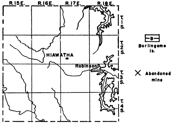
All the mines in Brown County have been small mines, most of them drifts, but in the area around Robinson there have been some small strip pits and shafts. In the northeastern part of the county there has been no mining recently, but just across the line in Nebraska several small mines have been opened and operated from time to time. One was reported to have been opened in 1938.
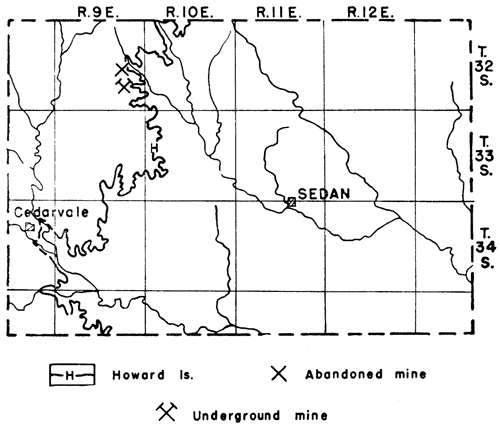
The Howard limestone containing the Nodaway coal crops out across the western part of Chautauqua County (fig. 14). The outcrop of the coal, however, is concealed by a soil covering in most places. The coal is 16 to 18 inches thick.
This coal was mined extensively for local trade near Leeds from 1890 until 1903, and has been mined occasionally since then. The dumps and tunnels of these mines can be seen today along the ravines north of the Leeds schoolhouse (the rest of the town burned a few years ago). A slope mine 0.25 mile north and 0.25 mile west of Leeds in the center of sec. 26, T. 32 S., R. 9 E., was operated in 1939. It was closed at the time of my visit in August, 1939, but the operator planned to reopen it in the fall as soon as there was a demand for coal. According to one of the men who worked in the mine, the coal is 18 inches thick and is overlain by 7 feet of black slaty shale. Four feet of limestone, the Church limestone member of the Howard formation, overlies the shale and is exposed at the entrance of the slope. A "fireclay" underlies the coal. The room-and-pillar method of mining is followed and an 18-foot room is used. In the earlier days, the coal was undercut by hand and wedged down from the roof. The present operator shoots the coal off the "solid" with black powder. An old Ford motor furnishes the power to pull the cars to the surface. Water is pumped from the mine by means of a gasoline-engine-driven pump. The coal is sold at the mine to truckers who haul it to Cedarvale, Arkansas City, and Winfield. Some is used, also, by farmers living near by. The price at the mine (fall, 1939) is $3 per ton. The miner receives $1.50 per ton for mining the coal, and 25 cents per ton is paid to the landowner for royalty and 25 cents for timber rights.
A mine is reported to have been worked near Cedarvale in 1938.
Figure 14--Outcrop of Howard limestone in Chautauqua County.
A lignite bed near the top of the Dakota group was mined to a considerable extent for local trade in the 1890's on the Cloud-Republic county line, about 6 miles north of Concordia. This bed is probably only local in occurrence as are the other lignite beds in the Dakota. It is 102 feet below the Jetmore limestone member of the Greenhorn formation, according to Wing (1930, p. 44), and 12 feet below the sandstone at the top of the Dakota. The bed between the lignite and the sandstone is a clay shale. A clay or shale underlies the lignite, also. No outcrops are exposed in the area where the lignite was mined.
The lignite is described by Wing as consisting of two layers, an upper layer about 8 inches thick and lower layer about 12 inches thick, which are separated by as much as 4 inches of "black Jack", or impure coal. The upper layer contains more sulphur and burns more quickly than the lower layer. Persons who have used this coal for fuel report that it produces no soot and leaves a large quantity of white ashes similar to wood ashes. It slacks readily when exposed to air and thus cannot be stored a very long period. Wing gives the following analysis of the coal:
| Analysis of Dakota lignite north of Concordia | |
|---|---|
| Water | 13.52 percent |
| Volatile matter | 46.14 percent |
| Fixed carbon | 28.52 percent |
| Ash | 11.64 percent |
The Curtis mine (pl. 1 A), 0.5 mile west of U. S. highway 81 on the Cloud-Republic county line, was being cleaned at the time of my visit in August, 1939, in preparation for operating during the ensuing fall and winter. It had been opened in 1936 and has been worked every winter since then. It is approximately 100 feet deep and is worked on the longwall system, 20-foot face rooms being used. Runways are made 4 feet high. The coal is undercut by hand, wedged down, loaded on small cars, and pushed to the bottom of the shaft by the miners. The hoist is operated by horse power.
Coal from this area is sold only on the local market. The price in 1939 was $4 per ton at, the mine.
Two coal beds crop out in Coffey County. One of these is in the Lawrence shale, 15 feet below the Oread limestone (fig. 15), and crops out in the southeastern part of the county. It is the same coal that is found in northwestern Anderson County. The coal, as shown on unpublished stratigraphic sections prepared by Newell, is about 12 inches thick and is underlain by 12 inches of underclay. The bed between the coal and the Oread limestone consists of gray to buff sandy shale.
The other coal is the Nodaway coal near the top of the Severy shale, just below the Howard limestone (fig. 15). It crops out across the northwestern corner of the county from Lebo to Neosho river east of Neosho Rapids. The coal is 12 inches thick and is underlain by a bluish-gray clay. Over the coal is 2 to 6 feet of bluish-gray to black shale, which in turn is overlain by 2.5 feet of massive limestone, the Church limestone member of the Howard formation.
Figure 15--Outcrops of Oread and Howard limestones in Coffey County.
No mines were operated in Coffey County in 1938. The Modaway coal has been mined east of Neosho Rapids and in the vicinity of Lebo, however. One strip mine operated at the northeast edge of Lebo until 1937. A small steam shovel was used to remove the 10 feet of overburden consisting of shale, weathered limestone, and soil. Several other strip mines and small slope mines near Lebo and several strip pits east of Neosho Rapids were worked from 1933 until 1935. Farmers at the present time are taking coal for their own use from the old strip pits east of Neosho Rapids.
Three coal beds are known in the Tonganoxie sandstone in the vicinity of Blue Mound, 5 miles southeast of Lawrence, but only the lowest one of these is more than 7 inches thick. It is the Blue Mound coal. The bed is 12 to 14 inches thick and lies about 55 feet below the top of the Tonganoxie sandstone. No outcrops have been seen by me, but the coal has been mined on the flanks of Blue Mound and at Sibleyville, 1 mile south of Blue Mound.
The coal at Sibleyville was mined about 1889, but by 1892, according to Haworth (IS92, p. 303), the mines were abandoned. The shafts have been filled since then. They are reported to have been 40 feet deep, and the coal is said to be 14 inches thick.
The Blue Mound coal in the Tonganoxie sandstone was mined from a small slope mine on the west flank of Blue Mound in 1934 and sold to persons who came to the mine to get it. The coal mined here is 12 inches thick. The slope was 30 feet deep and the hoist was operated by steam.
The Williamsburg coal, which is mined in Franklin County, extends northward into the western half of Douglas County and crops out along the tributaries of Wakarusa river, on Blue Mound, and from the vicinity of Baldwin southwestward to the county line. This coal lies in the Lawrence shale 30 to 40 feet below the Oread limestone. It is about 6 inches thick at most places in the county. Near the Douglas-Franklin county line, however, it is about 12 inches thick. In the vicinity of Lone Star State Lake there is 6 inches of good coal overlain by 12 to 14 inches of black carbonaceous shale containing thin streaks of coal. The coal is underlain by shale or underclay containing plant fossils. Over the coal is a shale, which grades upward into a sandy shale.
Haworth (Haworth and Crane, IS9S, p. 128) mentions that some coal was mined from the Williamsburg bed on Deer creek during the winter of lS97-1898 and placed on the Lawrence market.
Locally in the vicinity of Lone Star State Lake there is a coal bed 8 inches thick above the Williamsburg coal and only 10 feet below the Oread limestone.
The Howard limestone containing the Nodaway coal crops out along an irregular line north and south across the center of the county (fig. 16). The outcrop of the coal generally is covered with soil, however, so that few exposures of it are found.
Figure 16--Outcrop of Howard limestone across Elk County.
A slope mine,operated 2.5 miles south and 2.5 miles west of Howard until 1899. According to the report of the state mine inspector (1899), the coal mined was 18 inches thick. The slope was abandoned after a cave-in killed a man.
Several strip mines have been worked from time to time near Howard, the last one being abandoned in 1926. This mine was 2.75 miles west and 2 miles south of Howard. The coal is 16 inches thick and is overlain by 2 inches of blackjack, or impure coal. The overburden is reported to have been 6 to 13 feet, consisting altogether of shale. Farmers who used the coal also reported that the coal obtained where there was only 6 feet of overburden was a soft red coal that burned fast and left a large quantity of ashes, but where the overburden was thicker the coal was harder and better. The coal is underlain by shale.
Lignite is found in the upper part of the Dakota group at several places in Ellsworth County. The beds are local, however, and do not extend over very large areas. Figure 17 shows the occurrences of lignite in Ellsworth County.
Figure 17--Localities at which lignite has been found in Ellsworth County.
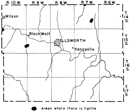
South of Black Wolf, about 7.5 miles west and 0.5 mile south of Ellsworth, lignite or lignitic beds are exposed on the sides of a hill and along a ravine. The lignite here ranges within very short distances from a pure lignite 13 to 18 inches thick to a zone of alternating bands of lignite and loose white sand in which the individual bands are not more than 1 inch thick, or to carbonaceous clay. The lignite is approximately 8 feet below the top of the Dakota. It is underlain by lignitic sandstone and overlain by clay or siltstone.
Plummer (personal communication) reports 5 feet of clayey lignite at this horizon in sec. 19, T. 15 S., R,. 9 W., about 0.5 mile east of the locality mentioned, and remarks that probably 3 feet of it could be burned. The lignite here is underlain by 2 feet of gray to dark-gray lignitic clayey silt and is overlain by a gray, slightly lignitic siltstone.
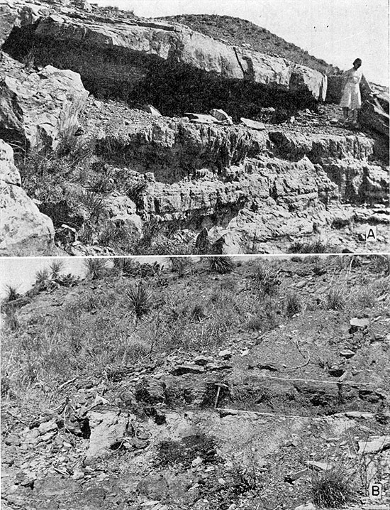
Several lignite beds are exposed on the sides of hills and in the canyons that are tributary to Smoky Hill river, 2.5 miles south of Wilson on the west side of Ellsworth County. One of these beds (pl. 3B) is 11 to 14 inches thick and has been mined. It is underlain by shale, sandy shale, or shaly lignite, and overlain by shale or clay. A white sandstone 12 inches thick lies 3 to 6 feet above this bed and at some places a sandstone about 6 inches thick is found only 4 inches above it. The other lignite beds above and below the thickest bed range from 1 to 5 inches in thickness. They are all restricted to very small areas. Individual beds grade laterally into lignitic clays or shales. The lignite is near or at the top of the Dakota group.
A small amount of lignite was once stripped for local use along a ravine 5 miles north and 4 miles east of Kanopolis. The bed is very near the surface and so poorly exposed that no measurements could be made. Plummer reports the occurrence of 1.5 feet of lignite 1 mile north of this locality in sec. 23, T. 14 S., R. 7 W. It is underlain by a gray siltstone containing what are thought to be root molds. Between the lignite and the top of the Dakota is 5 feet of gray silt and fine sand containing some clay about 2 feet above the lignite.
Lignite is exposed, also, along Elkhorn creek on the Ellsworth-Lincoln county line, but will be described under Lincoln County.
Most of the lignite that has been produced in Ellsworth County has been mined on Elkhorn creek in the northern part and south of Wilson in the western part of the county. The greater amount of the lignite of both areas has been mined in the adjoining counties, however.
The Williamsburg coal crops out along an irregular line across the western part of Franklin County. It is 30 to 40 feet below the Oread limestone and ranges from 12 to 20 inches in thickness. The average thickness is 16 inches. It is thickest in the area between Williamsburg and Pomona, thinning north of Pomona and south of Williamsburg. The bed between the coal and the Oread limestone consists principally of shaly sandstone and sandy shale, but the lower 3 feet is a clayey shale locally containing abundant plant fossils. Coal seams 0.10 to 0.75 inches thick occur at some places in the clayey shale above the coal. Below the coal in the southwestern corner of the county is a limestone 1 to 3 feet thick. In some places the coal rests on the limestone and at others a thin underclay separates them. The limestone disappears a short distance north of Williamsburg, however. Figure 18 is a map of Franklin County showing the outcrop of the Oread limestone above the Williamsburg coal and the locations of the mines.
Figure 18--Outcrop of Oread limestone in Franklin County and locations of mines.
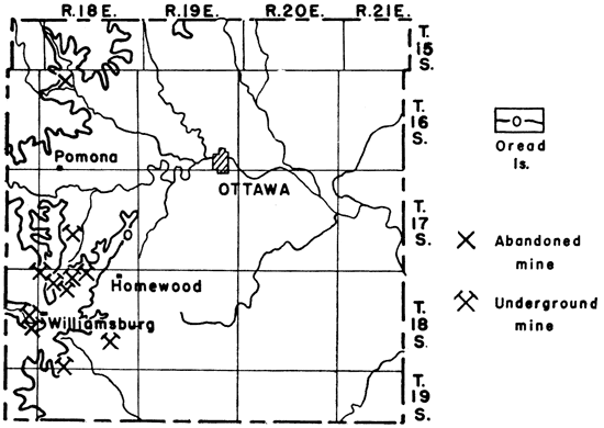
The Williamsburg coal has been mined mainly in the southwestern part of the county. In 193S there were 14 mines operating in an area extending from a point 3 miles south and 4.5 miles east of Williamsburg as far northward as Homewood. These consisted of 8 drifts, 5 shaft mines, and 1 slope mine, according to a report of the state coal mine inspector (193S, pp. 26-27). There are several abandoned strip mines near Williamsburg, but no strip mines were operating in 1938 or 1939. A drift mine was operated 5 miles north and 0.5 miles east of Pomona in 1936.
The deep mines range from 15 to 74 feet in depth, the average being about 35 feet. Gasoline engines are used to operate the hoists of four of the shaft mines and of one drift mine. In one shaft mine and the slope mine, horse power is used to operate the hoists.
The longwall method of mining is used in all the mines. The coal is undercut by longwall machines in most of the mines, but in a few the work is done by hand. Because of the limestone bed immediately under the coal, where the machines are used cutting is done in the lower part of the coal, a layer 5 inches thick being taken from the bottom of the seam. The remaining coal is wedged down after being undercut. The machines used in this district cut a swath 27 inches wide under the coal. Explosives are used only in shooting down the roofs of the runways.
The main haulageways in the mines are 4 feet wide and 4 to 4.5 feet high, except in some of the smaller mines, where they are not quite that high. The entries to the coal face are 4 feet wide and 2.5 to 3 feet high. The face rooms are 40 feet wide, extending 20 feet on each side of the entry, and are about 20 inches high. The entries, in turn, are 40 feet apart. The coal is hauled to the bottom of the shaft, or to the entrance of the drift, on cars that are pushed by band.
The largest mine in the district, one belonging to the Couch Coal Company, ordinarily produces a maximum of 45 tons per day, although as much as 70 tons has been run in one day. This mine employs 13 men, including the machine man. According to the report of the state mine, inspector (1938, p. 43), 85 men were employed in the Franklin County mines in 1938.
The coal produced in this district is sold direct to trucks at the mine and is hauled to Lawrence, Ottawa, and points west of Williamsburg. In 1938 the price varied between $2.75 and $3 per ton at the mines. The cost of mining at the Couch coal mine is estimated at $2 per ton based on a minimum production of 30 tons per day. The cost is greater when the daily production is less than 30 tons. The coal is sold either as mine-run or as lump coal.
The Elmo coal, which lies a few feet below the Burlingame limestone, crops out near Larkinburg in the extreme eastern part and along Muddy and Cedar creeks in the extreme southeastern part of the county. Haworth (Haworth and Crane, 1898, p. 129) mentions that a few mines along Muddy and Cedar creeks were operated in 1898.
Coal beds at two stratigraphic horizons crop out in Jefferson County, the Nodaway coal, just below the Howard limestone, in the northern and western parts, and the Elmo coal, a few feet below the Burlingame limestone, in the western part (fig. 19). Both these coal beds have been mined to a small extent by farmers for their own fuel.
Figure 19--Outcrops of Howard and Burlingame limestones in Jefferson County. The Nodaway coal is 2 to 2.5 feet below the Howard limestone. The Elmo coal is about 25 feet below the Burlingame limestone.
The Nodaway coal is 8 to 12 inches thick and lies 24 to 30 inches below the Church limestone member of the Howard formation. The rock between the coal and the limestone consists of a blue-gray shale, which in some places contains a black fissile shale just above the coal. Near Rock creek the black fissile shale above the coal is 5 inches thick. Below the coal is an underclay, which grades downward into a shale.
The Nodaway coal has been mined in an area 1 mile south of Valley Falls since 1924. At one time 13 diggers were employed. One mine was operating there on a small scale in 1939 to provide fuel for the owner. It is a drift mine dug into the side of a hill following the coal from the outcrop. The main haulageway is 4 feet wide and reaches from a layer 15 to 18 inches below the coal to the limestone 29 inches above it. The room in which the miner works is 24 feet wide. About 15 to 18 inches of underclay and shale is removed below the coal by the use of dynamite, and then the coal is knocked down. The shale above the coal remains in place. The coal at this mine is 8 to 9 inches thick and contains clay seams and some pyrite. The cost of mining is estimated to be $4 per ton.
The Elmo coal in Jefferson County is similar to that in Atchison County.
No coal or lignite crops out in Jewell County, but according to the state coal mine inspector, lignite was mined near Jewell from 1902 to 1906. The mines were shaft mines situated 3 to 3.5 miles east of town and they were about 160 feet deep. The lignite, according to Crane (1903, p. 94), is 30 inches thick and is overlain by shale and fireclay. He includes a geologic section of one of the shafts, which shows a sandstone 19 feet thick lying 30 feet above the lignite bed. The following analysis of the coal also is given by Crane:
| Analysis of Dakota lignite east of Jewell | |
|---|---|
| Water | 6.61 percent |
| Volatile matter | 29.00 percent |
| Fixed carbon | 45.25 percent |
| Ash | 19.14 percent |
The Sibley coal at or near the top of the Tonganoxie sandstone crops out in Leavenworth County. Exposures of the coal are difficult to find, however, because the outcrops are covered at many places with glacial material and loess, and at many other places with soil. A few exposures are found along streams and in road cuts. The outcrop of the Sibley coal, as taken from a map by Patterson (1933), is shown in figure 20. This figure also shows the locations of the mines in Leavenworth County.
Figure 20--Outcrop of Sibley coal in Leavenworth County and locations of mines. The location of the coal outcrop is taken from a map by J. M. Patterson.
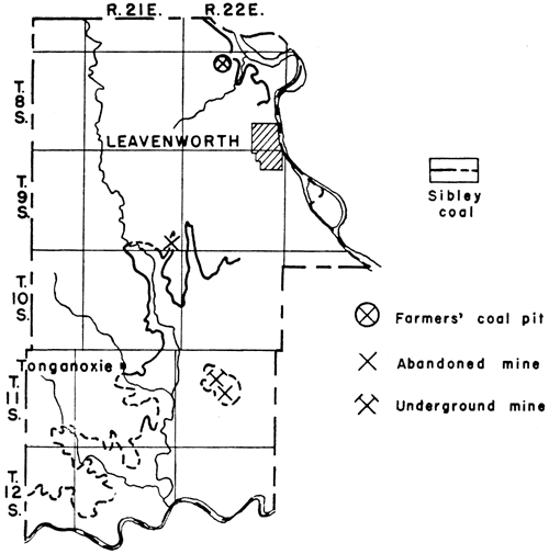
The coal lies 11 to 33 feet below the Haskell limestone and is 6 to 22 inches thick. The thickness ranges between 16 and 22 inches in the mines 6 miles east of Tonganoxie and, according to Hinds and Greene (1917, p. 11), between 18 and 24 inches along Little Stranger creek, 12 miles northeast of Tonganoxie. I measured 15 inches of coal exposed along a creek in sec. 36, T. 9 S., R. 21 E., but the upper part of the bed was concealed under loess and glacial till. The thickness of the coal ranges from 12 to 14 inches in the outcrop along Plum creek, about 5 miles north of Leavenworth. The outcrop here is shown in plate 2B. The coal bed obviously thins to the north, west, and south of the area of greatest thickness.
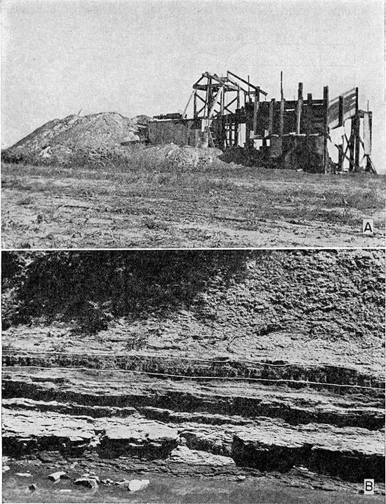
Plate 2--A, Shaft mine 6 miles east of Tonganoxie in the NW sec. 9, T. 11 S., R. 22 E., Leavenworth County; B, Outcrop of the Sibley coal along Plum creek near the center sec. 4, T. 8 S., R. 22 E., about 5 miles north of Leavenworth.
The rock between the coal and the Haskell limestone in the southern part of the county consists of shale containing sandstone or sandy shale at the top. North of Leavenworth the coal is separated from the Haskell limestone by 15 feet of blue-gray shale overlain by 18 feet of limy shale containing limestone lenses. The coal is underlain in most places by shale or sandy shale, but a blue-gray sandstone underlies the coal in sec. 36, T. 9 S., R. 21 E.
The Sibley coal is mined 6 miles east of Tonganoxie. In 1934 there were 3 mines operating, one shaft mine and two slope mines. Only one mine was open at the time of my visit in 1939, however, and it operates only during the winter months. A view of this mine is shown in plate 2A. It is a shaft mine 46 feet deep and is situated 0.5 mile north of U. S. highway 40. A gasoline engine is used to operate the hoist. The coal is mined by hand and sold as mine-run to persons who come to the mine for it. The price at the mine is $3.50 per ton (1939).
The Sibley coal was mined along Little Stranger creek about 5 miles west of Lansing in lS61, but little coal has been mined there since. Occasionally, however, someone starts a drift or puts down a slope in that area to obtain coal for his own use or for sale to persons living near by. No mines were operating there in 1939, but I saw several abandoned drifts and one abandoned slope.
Farmers have been taking coal for their own use from the outcrop on Plum creek, north of Leavenworth, during the fall and winter of 1939.
The upper part of the Dakota group contains lignite at several places in Lincoln County (fig. 21). The distribution is local, however, as in Ellsworth County. The lignite was mined during the latter part of the 19th century at places 9 miles north of Sylvan Grove along Spillman creek, 2.5 miles north of Denmark along Little Timber creek, and in the southern part of the county along Elkhorn creek.
Figure 21--Lignite occurrences in Lincoln County.
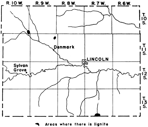
The lignite bed along Elkhorn creek in the southern part of the county lies between two fine-grained sandstones at the top of the Dakota. The distance between the two sandstones ranges from 24 inches to a maximum of 42 inches observed by me. At the entrance to an abandoned drift mine in sec. 33, T. 13 S., R. 7 W., shown in plate 3A, the thickness of the strata between the sandstones is 42 inches, the lower 24 inches consisting of lignite and the upper IS inches consisting of lignitic clay. Ten feet back from the entrance the entire thickness of beds between the two sandstones is lignite. At the entrance to this abandoned mine the upper sandstone is 4 feet thick and the lower one 10 feet thick.
The outcrops of lignite along Spillman creek and Little Timber creek, where the lignite was formerly mined, are covered with soil or alluvium so that exposures are difficult to find. The lignite bed must lie at or near the top of the Dakota group, because at both places the Graneros shale crops out along the sides of the creek valleys. The lignite near Denmark along Little Timber creek is 22 inches thick (state coal mine inspector, 1893) and that north of Sylvan Grove along Spillman creek is 16 inches thick.
Plate 3--A, Entrance to an abandoned drift mine 10 miles south and 2 miles east of Lincoln in sec. 33, T. 13 S., R. 7 W., Lincoln County; B, Lignite exposed on side of canyon 2.5 miles south of Wilson in the NW sec. 6, T. 15 S., R. 10 W., western Ellsworth County.
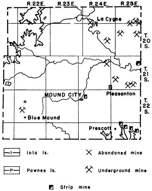
Two coal beds at different stratigraphic horizons crop out in Linn County, the Mulberry coal in the Bandera shale, a few feet above the Pawnee limestone, and the Thayer coal in the Chanute shale, a short distance below the Iola limestone. The Mulberry coal is the more important of the two, although both coal beds are mined in the county. The outcrops of the Pawnee and the Iola limestones in Linn County, as well as the locations of the mines, are shown in figure 22.
Figure 22--Outcrops of Pawnee and Iola limestones in Linn County. The mines are indicated by symbols.
The Mulberry coal crops out along an irregular line across the southeast corner of the county, along tributaries of Osage river in the eastern part of the county, and in a small area at the northeast edge of Mound City. It is 3.5 feet above the Pawnee limestone and is 18 to 42 inches thick, the average thickness being 30 inches. The rock between the coal and the limestone consists of shale grading upward into an underclay under the coal. The Bandera shale above the coal consists of sandy shale.
A characteristic of the Mulberry coal that is persistent throughout the county is the occurrence of a pyrite seam 15 to 18 inches above the bottom of the bed. This seam is actually a layer of flat pyrite nodules or concretions. Most of the nodules are about 1 inch thick and none are more than 1.5 inches thick.
"Faults," as they are called by the miners, cut across the coal at a few places. They are not true faults, however, because the coal bed is not offset and at some places the "faults" do not cut completely across the coal. The so-called "faults" consist of clay and pyrite seams cutting across the bedding of the coal and probably are filled fractures.
"Rolls" also occur at a few places and are encountered more frequently in mining than are the "faults." They are the slight dipping or bulging of the shale above or below the coal. They are ordinarily 2 to 3 feet across.
The average of the two analyses of samples of the Mulberry coal from Linn County that are given by Allen (Young and Allen, 1925, pp. 163-164), shows:
| Analysis of Mulberry coal from Linn County | |
|---|---|
| Water | 6.01 percent |
| Volatile matter | 34.03 percent |
| Fixed carbon | 42.95 percent |
| Ash | 17.00 percent |
| B.T.U. | 11,047 |
The Mulberry coal is mined in Linn County in the area extending from Pleasanton and La Cygne eastward to the state line, in the area east of Prescott, and near Mound City (fig. 22). Farmers also are obtaining coal for their own use near Manty, 6 miles west of Prescott. There are several abandoned strip pits in the area east and southeast of Manty.
Almost all the mines in the area extending from Pleasanton and La Cygne eastward to the state line are deep mines. According to the state coal mine inspector, the 15 mines operating there during 1938 included 11 shaft mines, 3 slope mines, and 1 strip mine. The deep mines range in depth from 40 to 140 feet, but the average depth is between 60 and 70 feet. Hoists are operated by steam power or by gasoline engines except at one mine, where electric power is used.
For underground mining the cross-entry room-and-pillar method is used. Young (Young and Allen, 1925, p. 116) reports that the longwall method was used in the district at one time, but that it was not successful because the top would not stand well at the face. The top stands well if the room-and-pillar method is used. Entries generally are driven 16 to 20 feet wide and gobbed on one side with a 12-foot pillar between. Most of the mines are dry and there is very little gas. In most mines the coal is shot off the "solid," but at a few of the mines the coal is undercut by machines and a light shot is used to bring it down. The coal in the deep mines averages 32 inches in thickness.
The one strip mine in the area east of Pleasanton and La Cygne is near the Missouri line, 0.5 mile south and 1 mile west of Amoret, Mo. The coal there is 26 inches thick. About 12 feet of overburden consisting of sandy shale is removed by a dragline.
All the mines in the area east of Prescott are strip mines. Four mines were operating there in 1938, according to the report of the state coal mine inspector for that year. About 14 feet of overburden consisting of blue-gray shale is removed by small steam shovels having a capacity of 1 to 2 yards. The coal is pried, or sometimes blasted, loose and loaded into trucks by hand. The coal taken from these mines is about 26 inches thick.
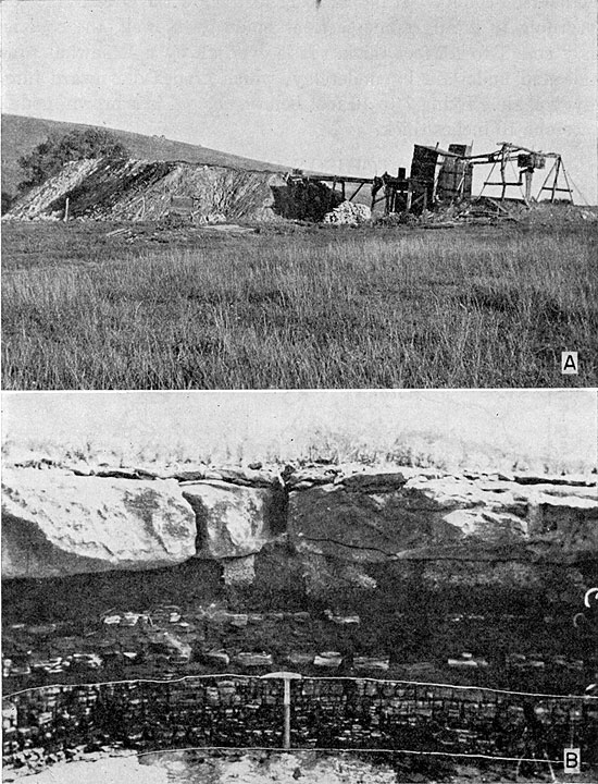
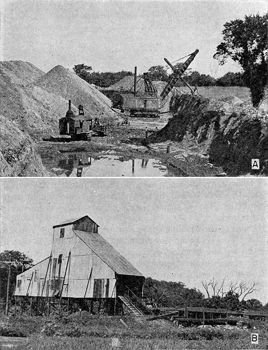
One strip mine was operating 0.5 mile northeast of Mound City in 1939 (pl. 4A). This mine is equipped with an electric tipple (pl. 4B) and has a connection with the Missouri Pacific Railroad. A 4-yard steam shovel is used for removing the overburden and a mechanical loader operated by steam loads the coal into trucks to be hauled to the tipple. The overburden consists of shale 12 to 35 feet thick. The coal is only 18 inches thick, so most of the stripping is done where the overburden is 15 to 20 feet thick.
Plate 4--A, Strip mine 0.5 mile northeast of Mound City in sec. 8, T. 22 S., R. 24 E.; B, Electric tipple at the strip mine northeast of Mound City.
Most of the coal produced from the Mulberry bed in Linn County is sold for domestic consumption. All the mines are custom mines, producing coal only as there is a demand for it. The coal generally is sold at the mine to truck drivers, who haul it to towns in the surrounding territory and retail it to the consumers. Linn, Miami, Johnson, and the adjacent counties in Missouri provide the market for a large percentage of the coal from Linn County. Some is marketed in Kansas City, also. Some coal is sorted into pea, nut, and lump sizes, but some is sold as mine-run. The price at the mines for mine-run coal is $2 per ton (1939). A royalty of 12.5 cents per ton is paid to the landowner.
The Thayer coal in the Chanute shale crops out along an irregular line across the northwestern corner of Linn County and around some outliers just north and northwest of Blue Mound. It is 4 to 7 inches thick at most places in the county and is overlain by a sandy shale that grades upward into a sandstone in the northwestern corner of the county. Near Blue Mound, however, the coal thickens to 12 inches and is overlain by a thin-bedded sandstone, the Cottage Grove sandstone. Below the coal is an underclay, which is underlain by shale.
The Thayer coal has been mined locally where it crops out around the outliers a short distance north and northwest of Blue Mound. One small shaft mine, 0.5 mile west and 1 mile north of town, operated during the winter months of 1938 and 1939. The shaft is only 8 feet deep, however, and the hoist is operated by an old automobile engine. The haulageway is 3 feet wide and 2.5 feet high. The very small amount of water that accumulates in the bottom of the shaft is removed by a small hand pump. The coal is sold on the local market.
The Nodaway coal crops out across the southeastern corner of Lyon County near Neosho Rapids and Hartford. The coal here is similar to that in Coffey County, which has been described already. It is reported to have been mined at one time near Hartford.
A shaft mine 1 mile east of Admire is reported by the state coal mine inspector (1934, pp. 64, 66, 81) to have operated in 1934. The coal is reported to be 16 inches thick and the shaft 47 feet deep. This coal may be the Nyman coal below the Dover limestone.
A lignite bed occurring near Saltville, sec. 21, T. 9 S., R. 7 W., in southeastern Mitchell County was mined for local consumption during the years before 1900. The mines were all drift openings. The lignite is local in occurrence and lies near the top of the Dakota group. It averages 14 inches in thickness where it was mined.
The Thayer coal in the Chanute shale crops out along an irregular line north and south across the center of Montgomery County and in the northeast part of the county. The thickness of the coal ranges from 4 to 12 inches, but in most places it is about 10 inches. The coal is underlain by underclay, which grades downward into shale. The shale below the coal at some places is somewhat sandy; at other places there may be a thin concretionary limestone layer a short distance below the coal. Above the coal is a platy sandstone, the Cottage Grove sandstone, which ranges in thickness from 35 to 65 feet and at many places contains cross-bedded and massive channel sandstones that probably cut through the coal at some places.
The Thayer coal has been mined to a small extent southeast of Independence, and it is reported that some persons living there mine coal for their own use at the present time.
The coal in Neosho County is the Thayer coal. It crops out along an irregular line across the western part of the county. The thickness of the coal ranges from 3 to 7 inches between Chanute and Thayer, but west and southwest of Thayer it is 12 to 14 inches. An underclay 3 to 12 inches thick underlies the coal. Below that is a blue-gray shale. Above the coal is the platy thin-bedded Cottage Grove sandstone, containing at many places massive channel sandstones, which locally cut into and probably even completely through the coal. The Cottage Grove sandstone is 6 feet thick near Chanute, but southwest of Thayer it thickens to almost 40 feet. Locally west and southwest of Thayer, it contains thin beds of coal above the Thayer coal. Most of these thin coal beds are 1 to 6 inches thick.
The Thayer coal is mined in the southwestern part of the county, west and southwest of Thayer. In 1938 there were nine small drift mines operating, as reported by the state coal mine inspector (1938). The mines are worked only during the fall and winter months. Individuals pay the landowner 75 cents to $1 per week for the privilege of mining and selling the coal. The coal is sold on the local market.
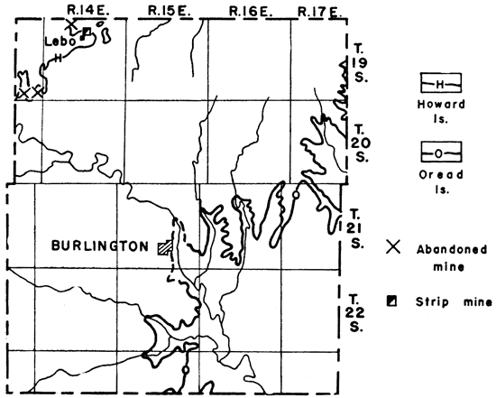
Both the Williamsburg coal in the Lawrence shale, a short distance below the Oread limestone, and the Nodaway coal near the top of the Severy shale, a few feet below the Howard limestone, crop out in Osage County. A map with the lines of outcrop of these two limestones, as well as the locations of the mines, is shown in figure 23.
Figure 23--Outcrops of Oread and Howard limestones in Osage County and locations of mines.
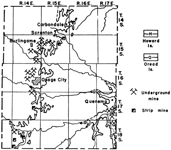
The Williamsburg coal crops out in the eastern part of the county along Osage river and its tributaries. Its thickness ranges from 12 to 16 inches, but averages 15 inches. The character of the coal resembles that of the same bed north of Williamsburg in Franklin County, just a short distance eastward.
The Williamsburg coal is mined south of Quenemo in a small area extending 6 miles south and 2 miles west of the town. Four small drift mines operated there during 1938. The coal is dug with a pick and loaded on a small car, which is pushed to the entrance of the drift by hand. The price received for the coal is the same as that at Williamsburg.
The Nodaway coal crops out along an irregular line across Osage County from the southern boundary of Shawnee County, north of Carbondale, to the northern boundary of Coffey County north of Lebo. Its thickness ranges from 12 to 22 inches and is reported in one mine to be 30 inches, but the average is 15 inches. The coal lies 10 feet below the Church limestone member of the Howard limestone. The Church bed is 18 inches thick and caps the hills along the line of outcrop. The rock between the coal and the limestone consists of a blue-gray shale, the lower 6 feet of which is almost a massive clay shale. The upper part is thin-bedded and somewhat sandy. Below the coal is a thin underclay, which grades downward into a shale. The coal contains no clay seams or partings and separates readily from both the top and the bottom in the mining operations.
Small faults cut the coal at a few places. One such fault observed by me in a mine 1.25 miles south of Burlingame displaces the coal as much as 6 inches. The fault is a normal fault, dipping 45° north and striking east-west. Difficulty is encountered in mining near the faults, because the coal is offset vertically and because the shale on the footwall side tends to fall with the coal. These faults are not very numerous, however.
Allen (Young and Allen, 1925, p. 182) gives the analyses of 17 samples of the Nodaway coal in Osage County. The average of these analyses shows:
| Analysis of Nodaway coal in Osage County | |
|---|---|
| Water | 6.68 percent |
| Volatile matter | 35.22 percent |
| Fixed carbon | 48.46 percent |
| Ash | 8.44 percent |
| B.T.U. | 10,682 |
Both stripping and underground methods are used in mining the Nodaway coal. The hills in the vicinity of Carbondale and southward along the line of outcrop are marked with strip mines, most, of which are abandoned. Seven strip mines, however, were operating in the county in 1938. These are near Carbondale and Scranton and in the southern part of the county near Arvonia. The overburden is 12 to 16 feet thick and includes 10 feet of shale and 18 inches of limestone. At three of the mines this overburden is removed by small steam shovels of 1.5- to 2-yard capacity. The limestone is shattered by blasting so that the shovels can move it. The operators of one mine, 1 mile east of Carbondale, use two shovels in the stripping process, a 2-yard shovel to remove the overburden down to the massive clay shale and a 1.5-yard shovel (pl. 5B) to remove the remaining overburden down to the coal. The overburden at the rest of the strip mines is removed by means of teams and scrapers. The coal is pried loose, broken into large lumps, and loaded into trucks by hand. None of the strip mines have railroad connections.
There are 22 deep mines in Osage County (according to the state coal mine inspector) from which the Nodaway coal was mined in 1938. These are near Scranton, Burlingame, and Osage City. They are all shaft mines and all but five of them use electric power for operating the hoists. The hoists at three of the mines are operated by horse power and at two by gasoline engines. The depth of the mines ranges from 25 to 118 feet. Three mines have connections with the Santa Fe railroad and two with the Missouri Pacific. Plate 5A shows one of the deep mines near Osage City.
Plate 5--A, Surface view of a shaft mine 1 mile northwest of Osage City in the NE sec. 22, T. 16 S., R. 14 E.; B, Small steam shovel operating in a strip pit 1 mile east of Carbondale in the NE sec. 19, T. 14 S., R. 16 E.
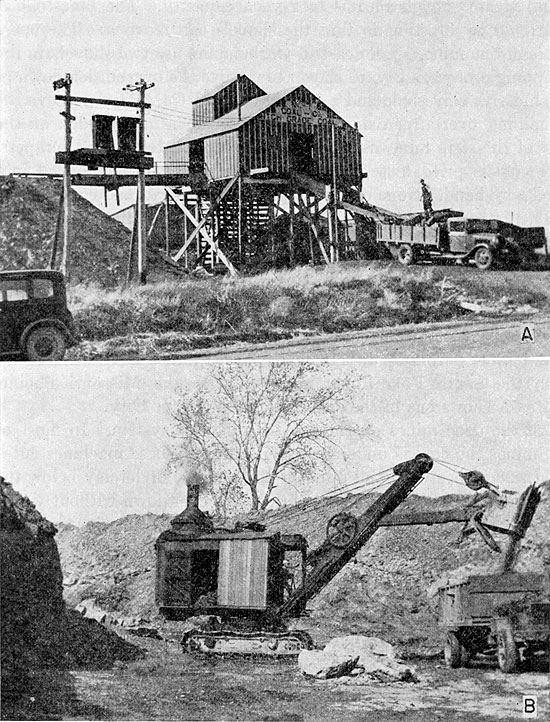
All the deep, mines operate on the longwall system. In most of the mines the coal is undercut by machines. These machines cut a swath 28 inches wide and 6 inches thick in the underclay below the coal, and the weight of the roof brings the coal down without wedging or shooting. Explosives are used only in shooting down the entries and the main haulageways. The main haulageways, which lead out from the bottom of the shafts, differ considerably in size. In some of the mines they are as much as 12 feet wide and 10 feet high, the roof being formed by the Church limestone above the coal. The entries leading to the coal face are ordinarily 3.5 to 4 feet high and 3 to 3.5 feet wide. The face rooms extend 20 feet on each side of the entry, the entries being 40 feet apart. The coal along the face is kicked out by the miners and loaded on cars at the entries. In some of the mines these cars are pushed all the way to the bottom of the shaft by hand; in others, they are pushed by hand to the main haulageways, but are taken the rest of the way by mules or motors. The mines contain no gas and are usually dry.
The coal produced in Osage County is hauled directly from the mines without treating or sorting. Those mines having railroad connections ship some coal by rail, but the larger part of the coal is sold at the mine to truckers, who in turn sell it to the dealers, or direct to the consumers, in the surrounding territory. Some of the coal is sold to the railroads, some is used locally for generating steam, but far the largest part of it is used for domestic purposes. The market for coal from Osage County, besides the local market, lies north, northwest, west, and southwest of the county, and includes the towns of Topeka, Abilene, Salina, Beloit, and Emporia. The coal is sold at the mines for $3 per ton (1939).
A lignite bed near the top of the Dakota group has been mined in the southern part of Republic county near the Republic-Cloud county line. This lignite is the same bed that is mined in northern Cloud county and already has been described.
Lignite has been mined at several places in Russell County. The individual beds are local in occurrence, but they all lie near the top of the Dakota group. Figure 24 shows the occurrences of lignite in Russell County.
Figure 24--Occurrences of lignite in Russell County.
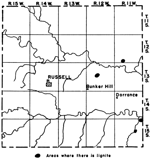
The lignite beds that crop out 3 miles south of Wilson in Ellsworth County extend westward into southeastern Russell County and crop out, along ravines leading to Smoky Hill river. During, the latter part of the 19th century lignite was mined there from drifts by the longwall system of mining. All that was produced was sold on the local market.
A lignite bed 24 to 28 inches thick crops out along Coal creek in sec. 14, T. 15 S., R. 11 W., 2 miles west and 3 miles south of the locality south of Wilson just mentioned. The lignite is not continuous between the two places, however. The lower part of the bed here contains some impurities, but the upper 10 to 12 inches is pure. It is overlain by at least 4 feet of gray sandstone, which is overlain by shale or clay. A clay shale that is almost white underlies the lignite. This bed has not been mined.
A lignite bed 11 inches thick was mined at one time 3.5 miles northeast of Bunker Hill. It is underlain by 6 inches of impure lignite, or "blackjack," which becomes brown upon exposure to weathering. Below this is 12 inches of underclay resting on a black to dark-gray shale. A massive sandstone, which may represent the upper sandstone of the Dakota group, occurs 9 inches above the coal. This sandstone is about 12 feet thick. Between the lignite and the sandstone is a black carbonaceous clay.
A lignite that crops out in the SE sec. 32, T. 12 S., R. 11 W., on what is known as the Cooper ranch, is reported to have been mined to a small extent during the winter of 1938-39 and sold on the local market.
Coal beds at three different stratigraphic horizons crop out in Shawnee County, the Nodaway coal near the top of the Severy shale just below the Howard limestone, the Elmo coal in the Cedar Vale shale just below the Rulo limestone, and the Nyman coal in the Table Creek shale a few feet below the Dover limestone (fig. 25).
Figure 25--Outcrops of Howard, Burlingame, and Dover limestones in Shawnee County.
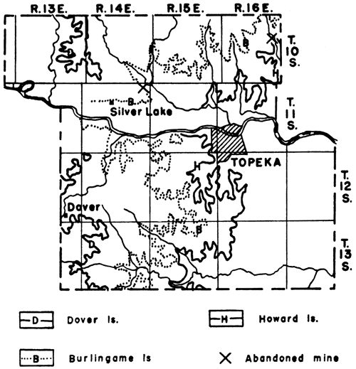
The Nodaway coal crops out along an irregular line from the northeastern part of the county to the west edge of Topeka and from Topeka south to the Shawnee-Osage county line. It is 5 to 12 inches thick and lies 1.5 to 4 feet below the Church member of the Howard limestone. R. C. Moore (1932, p. 55) shows 4 feet of blue, very fossiliferous shale between the coal, reported to be 5 inches thick, and the Church limestone on a stratigraphic section of an exposure in an abandoned shale pit 0.25 mile north of Gage Park at the west edge of Topeka. North of Kansas river, the beds between the coal and the limestone are 26 to 40 inches thick and consist of black platy shale in the lower part and of gray to buff, somewhat sandy shale in the upper part. South of Topeka, in an exposure 2.5 miles south and 1 mile west of Pauline, 19 inches of shale separates the coal from the limestone, the lower 10 inches being black platy shale and the upper 9 inches a buff shale. The coal at the exposure near Pauline is underlain by 7 inches of blackjack, or a mixture of coal, carbonaceous matter, and clay, which in turn is underlain by an underclay.
During the latter part of the 19th and the early part of the 20th centuries the Nodaway coal was mined on a small scale west of Topeka at the present site of Gage Park. The coal was sold in Topeka. Local residents in the northeastern part of the county dig a little coal occasionally for their own use or for sale. A small tunnel is reported to have been started 2 miles west of Meriden in 1.936 and a few bushels of coal was dug and sold in Topeka for 12.5 cents per bushel.
The Elmo coal crops out along an irregular line from the northeastern corner of the county to Silver Lake and from Silver Lake southward across the western part of the county. South of Kansas river, however, it is only a few inches thick. This coal was mined at one time in sec. 1, T. 11 S., R. 14 E., 2 miles north of Kiro station and 3 miles east of Silver Lake. Coal blossom 14 inches thick is exposed at the top of a railroad cut there, 12 feet above the tracks. It is overlain and underlain by shale. A cross-bedded channel sandstone occurs in the shale at the level of the tracks.
The Nyman coal crops out in the western part of the county near Dover and is described under Wabaunsee County.
The Nyman coal crops out in northeastern Wabaunsee county near Dover. It occurs in the Table Creek shale 11 feet below the Dover limestone (fig. 26) and is about 8 inches thick. The coal is dull black and soils the hands easily when it is handled. It contains a considerable amount of pyrite in the form of nodules, or concretions, scattered through it. Underlying the coal is about 3 inches of black carbonaceous underclay, which grades downward into a blue-gray shale. That part of the Table Creek shale above the coal is mostly a sandy shale, but just above the coal is 2 to 6 inches of blue-gray shale that grades into a layer of shaly limestone 1 to 6 inches thick.
During the fall of 1939 the coal was being dug from the outcrop at a place 2.5 miles west and 0.5 mile north of Dover by farmers, who were digging it for their own use.
Figure 26--Outcrop of Dover limestone in Wabaunsee County.
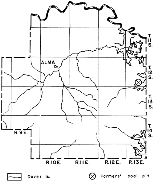
The Thayer coal, which is the coal that is mined to some extent in Neosho County, is mined in Wilson County, also. It crops out in the southeast quarter of the county. The coal lies 1.5 to 65 feet below the Iola limestone (fig. 27) and is 12 to 22 inches thick. The area of greatest thickness is in secs. 21, 22, 28, and 29, T. 29 S., R. 17 E., 5 to 6 miles west of Thayer. A clay parting, which ranges from a thin streak to as much as 4 inches in thickness, lies 6 to 9 inches below the top of the coal. Below the coal is 2 to 30 inches of underclay and below that is a shale. Between the coal and the Iola limestone is the Cottage Grove sandstone. This sandstone is only 18 inches thick in sec. 16, T. 29 S., R. 17 E., but it thickens rapidly to the south. It is 6 feet thick at the center of the west side of sec. 21, and 40 feet thick in the southeast corner of sec. 29 of the same township. On the Wilson-Montgomery County line the Cottage Grove sandstone is 65 feet thick and the Thayer coal is 65 feet below the Iola limestone.
Figure 27--Outcrop of Iola limestone in Wilson County. Taken from the geologic map of Kansas (1937).
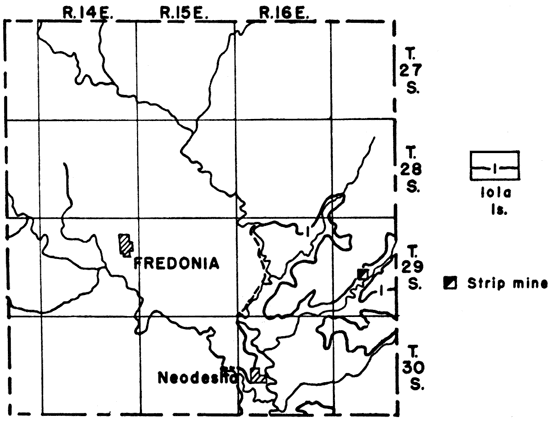
The Thayer coal has been mined in the eastern part of Wilson County near Thayer in much the same way as it has been in Neosho County. Most of the mines are drifts, but one strip mine was operating during 1939 in sec. 21, T. 29 S., R.. 17 E., 5 miles west and 0.5 mile north of Thayer. The overburden at this mine averages 12 feet in thickness and consists of 6 feet of relatively soft sandstone, 1 to 1.5 feet of limestone, 1 foot of black platy shale, 2 feet of buff clay shale, and a layer of weathered limestone. It is removed by a small steam shovel of 1.5-yard capacity. The limestone is shattered by blasting so that the shovel can move it. After the overburden is removed, the coal is pried loose and loaded into trucks by hand.
Several thin coal beds occur locally in the Cottage Grove sandstone where this sandstone thickens abruptly. These beds ordinarily are less than 6 inches thick. One bed, however, occurring in secs. 29 and 32, T. 29 S., R. 17 E., is 10 to 17 inches thick. It lies 6 to 10 feet below the Iola limestone and 30 to 40 feet above the Thayer coal bed. It disappears within a short distance to the north and to the east. This bed has been mined.
All the coal mined in Wilson County is sold on the local market.
A coal near the top of the Lawrence shale, which seemingly is a continuation of the Williamsburg bed, crops out across the northwestern part of Woodson County. It is 10 to 12 inches thick and lies 1 to 5 feet below the Oread limestone. The outcrop of the Oread limestone in Woodson County is shown in figure 28. Below the coal is an underclay, which at some places contains plant remains. The rock between the coal and the limestone consists of a somewhat clayey shale containing calcareous sandstone at some places near the top.
Figure 28--Outcrop of Oread limestone in Woodson County.
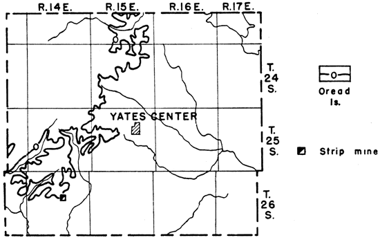
This coal is being mined from a small strip pit in the SE NW sec. 15, T. 26 S., R.. 14 E., approximately 7 miles west and 7 miles south of Yates Center. The overburden is about 5 feet thick and consists of 13 inches of clay shale, 6 inches of shaly fossiliferous limestone, 6 inches of white fossiliferous limestone, and the soil covering. Horses and scrapers are used to remove the overburden. The coal is sold to farmers for domestic fuel. It is used, also, at some of the near-by schoolhouses.
A small mine is reported to have operated at one time near Toronto.
Crane, W. R., 1903, Coal fields of north-central Kansas: Mines and Minerals, vol. 24, p. 94.
Greene, F. C., 1933, Oil and gas pools of western Missouri: Missouri Bur. Geol. and Mines, 57th Bien. Rept., App. 2, pp. 5-68.
Haworth, Erasmus, 1895, The coal fields of Kansas: Kansas Univ. Quarterly, vol. 3, no. 4, pp. 29,7-309.
Haworth, Erasmus, and Crane, W. R., 1898, Special report on coal: Kansas Univ. Geol. Survey, vol. 3, pp. 1-336.
Hinds, Henry, 1912, The coal deposits of Missouri: Missouri Bur. Geol. and Mines, vol. 11, 2d ser., pp. 1-480.
Hinds, Henry, and Greene, F. C., 1917, Leavenworth-Smithville folio, Missouri-Kansas: U. S. Geol. Survey Geol. Atlas, Folio 206, pp. 1-13.
Knerr, E. B., 1896, Coal in Atchison County, Kansas: Kansas Acad. Sci., Trans., vol. 14, pp. 216-217.
Landes, K. K., 1937, Mineral resources of Kansas counties: Kansas Geol. Survey, Min. Res. Cir. 6, pp. 1-102.
Moore, R. C., and Landes, K. K., 1927, Underground resources of Kansas: Kansas Geol. Survey, Bull. 13, pp. 1-147. [available online]
Moore, R. C., 1929, Kansas coal fields: U. S. Bur. of Mines, Tech. Paper 445, pp. 3-7.
Moore, R. C., 1932, Guidebook, Sixth Ann. Field Conference, Kansas Geol. Soc.
Moore, R. C., 1936, Stratigraphic classification of the Pennsylvanian rocks of Kansas: Kansas Geol. Survey, Bull. 22, pp. 1-248. [available online]
Patterson, J. M., 1933, The Douglas group of the Pennsylvanian system in Douglas and Leavenworth counties, Kansas: Master's Thesis, University of Kansas.
Pierce, W. G., and Courtier, W. H., 1937, Geology and coal resources of the southeastern Kansas coal fields in Crawford, Cherokee, and Labette counties: Kansas Geol. Survey, Bull. 24, pp. 1-122. [available online]
Saunders, W. H., 1873, Coals of Kansas: Kansas State Board of Agriculture, Trans. 1872, pp. 387-389.
Wing, M. E., 1930, The geology of Cloud and Republic counties, Kansas: Kansas Geol. Survey, Bull. 15, pp. 1-51. [available online]
Young, C. M., and Allen, H. C., 1925, Kansas coal: Kansas Univ. Bull., vol. 26, no. 5, pp. 1-202. (Also published as Kansas Univ. Engr. Exper. Sta. Bull. 13 and Chem. Research Div. Bull. 4.)
Kansas Geological Survey, Geology
Placed on web April 27, 2009; originally published in September 1940.
Comments to webadmin@kgs.ku.edu
The URL for this page is http://www.kgs.ku.edu/Publications/Bulletins/32/index.html