![]()
Prev Page--Ground Water Quality || Next Page--Well Records
Geologic Formations in Relation to Ground Water
Cretaceous System--Lower(?) Cretaceous Series
Dakota Formation
The Dakota Formation [Early(?) Cretaceous] does not crop out in Trego County, but it contains water within a practical drilling depth. In certain areas where shallow ground waters are scarce or not available, the Dakota is an important source of ground water.
The term "Dakota group" (Meek and Hayden, 1862) was first applied to the varicolored clay, sandstone, and lignite beds underlying the "Benton group" in exposures near Dakota City, Dakota County, Nebraska. The use of this grouping has been discontinued (Plummer and Romary, 1942), and the Dakota Formation now includes strata lying between the Kiowa Shale below and the Graneros Shale above. The Dakota Formation as defined by the State Geological Survey of Kansas has been variously referred to as "Dakota group" (Meek and Hayden, 1862); "Dakota sandstone" (Prosser, 1897); "Dakota formation" (Twenhofel, 1924); and "Cockrum sandstone" (Latta, 1941). Rubey and Bass (1925) referred to the upper 125 feet of the Dakota in Russell County as the "Rocktown channel sandstone member." Merriam (1957) used the term "Omadi formation" for the Dakota Formation in the subsurface of western Kansas.
Character and Subdivisions
In Kansas the Dakota Formation has been divided into two members (Plummer and Romary, 1942), the lower called the Terra Cotta Clay Member and the upper called the Janssen Clay Member. Plummer and Romary described the Dakota Formation as consisting chiefly of varicolored clay containing irregular, lenticular beds of siltstone and sandstone. The lower member is dominantly gray and red mottled clay. A zone of siderite, limonite, and hematite pellets marks the base of the upper member. Gray clay containing siderite pellets and yellow-orange coloring matter dominates the upper member, with lignite common in the upper part. Lenticular beds of sandstone occur throughout the Dakota Formation.
The Dakota Formation is present in the subsurface throughout the county. The depth to the Dakota ranges from about 300 feet below the land surface in the southeastern part of the county to about 1,000 feet below the land surface in the northwestern part.
Thickness
The thickness of the Dakota Formation is not uniform, probably because of the disconformity at the base. Frye and Brazil (1943, table 3) gave the thickness of the Dakota Formation in Ellis and Russell counties as 200 to 300 feet. Swineford and Williams (1945) gave a thickness of 213 to 300 feet for the Dakota in southwestern Russell County. Latta (1950) indicated the Dakota was 200 to 300 feet thick in northern Barton County. Hodson (1959) gave a thickness of about 350 for the Dakota near the Mitchell-Cloud county line. Leonard and Berry (1961) indicated that in southern Ellis County the thickness of the Dakota was only 155 feet. Hodson and Wahl (1960) gave a thickness of about 250 feet for the Dakota in Gove County. A study of drillers' logs indicated a thickness of 150 to 250 feet for the Dakota Formation in Trego County.
Water Supply
In the east-central and southern parts of Trego County, a number of wells obtain water for domestic and stock use from the Dakota Formation. Information on eight wells ranging in depth from 500 to 670 feet that derive water from the Dakota is given in Table 6, and chemical analyses of five water samples from the Dakota are given in Table 3. Water from the Dakota is more mineralized than water in the unconsolidated rocks, but generally the water is soft.
Depth to the water level in wells ranged from about 200 feet to about 400 feet below the land surface for wells obtaining water from the Dakota that were inventoried in this investigation. The sandstone lenses in the Dakota contain ground water under artesian pressure, and, although locally there are differences in hydrostatic pressure from well to well (Leonard and Berry, 1961, p. 26), ground-water investigations in much of Kansas suggest a connected hydrologic system among the sandstone lenses, for the most part.
Wells in the Dakota Formation in Trego County yield only quantities of water sufficient for domestic or stock supplies, although in some other areas in Kansas wells penetrating thick sandstones in the Dakota yield moderately large quantities of water, generally in areas nearer Dakota outcrops.
Cretaceous System--Upper Cretaceous Series
Graneros Shale
The Graneros Shale overlies the Dakota Formation and consists chiefly of dark-gray to black noncalcareous shale. The Graneros is present in the subsurface of Trego County where drillers' logs indicate it is 40 to 50 feet thick. It yields no water to wells in Trego County.
Greenhorn Limestone
The Greenhorn Limestone overlies the Graneros Shale and consists principally of about 100 feet of alternating thin beds of chalky limestone and calcareous shale. The Greenhorn Limestone is divided into four members, which, in ascending order, are the Lincoln Limestone, Hartland Shale, Jetmore Chalk, and Pfeifer Shale (Rubey and Bass, 1925; Bass, 1926). The chalky limestone and shale that comprise the Greenhorn are relatively impervious and do not yield water to wells in Trego County.
Carlile Shale
The Carlile Shale, consisting of the Fairport Chalk, the Blue Hill Shale, and the Codell Sandstone members, is the oldest formation exposed in Trego County. Only the upper part of the Carlile crops out, chiefly along the Smoky Hill Valley in the southern part of the county.
Character and Subdivisions
The Carlile Shale was named by Gilbert (1896) from exposures of gray argillaceous shale west of Pueblo, in Pueblo County, Colorado. Logan (1897) correlated Gilbert's section with Cretaceous rocks in north-central Kansas. Rubey and Bass (1925) divided the Carlile Shale into two members, the "Fairport chalky shale" below and the "Blue Hill shale" above. The Codell Sandstone Member (upper part of the Carlile Shale) was named by Bass (1926) from exposures along the Saline River in Ellis County, Kansas.
The Fairport Chalk, lowermost member of the Carlile Shale, consists of alternating beds of calcareous shale and thin, nodular, chalky limestone. The Fairport does not crop out in Trego County.
The Blue Hill Shale, middle member of the Carlile Shale, is the oldest rock unit exposed in Trego County. The Blue Hill crops out along the Smoky Hill Valley eastward from the junction of the Smoky Hill River and Hackberry Creek. The Blue Hill is well exposed on the steep slopes below the escarpment made by the Niobrara Chalk. Because the shale is soft, however, good exposures are rare elsewhere.
The Blue Hill Member is a blocky to fissile, clayey shale that characteristically weathers into small, brittle flakes. The predominant color of the shale is dark blue-gray, but locally the shale is light to dark olive-gray. Drill cuttings from the Blue Hill may be very dark-gray to black as shown in several logs of test holes at the end of this report. Thin lenses of siltstone, fine-grained sandstone, and sandy shale are common in the upper part of the Blue Hill and become more abundant upward.
Concretions characterize outcrops of the Blue Hill. Most of the concretions are found in zones and become much more abundant in the upper part. Most of the concretions are calcareous septarian concretions, but noncalcareous clay-ironstone concretions are common, and, locally, calcareous sandstone concretions are found. The concretions range in diameter from a few inches to as much as 3 feet. Most are ellipsoidal or discoidal, but smaller concretions may be nearly spherical. The concretions contain intersecting veins of brown calcite that on weathering tend to stand out in relief.
The Codell Sandstone Member marks the top of the Carlile Shale. In Trego County, outcrops of the Codell consist of a zone of rust-brown fine sand, sandy silt, and clayey silt. It is generally very argillaceous; shark teeth and bone fragments are common in it. In fresh exposures, the Codell is light gray to gray. Specks of disseminated limonite cause an orange to yellowish-brown coloration In weathered outcrops. The contact between the Codell and the underlying Blue Hill Shale Member is gradational, whereas the contact between the Codell and the overlying Fort Hays Limestone Member of the Niobrara Chalk is generally sharp.
The thickness of the Codell Sandstone Member changes laterally in Trego County, but usually about 2 or 3 feet of Codell is Present. Locally, however, as much as 5 feet of sandy silt representing the Codell was observed, while at a few localities, only a few inches was noted. A study of drillers' logs indicated that in the northeastern part of the county, the Codell may be as much as 20 feet in thickness. Hattin (1962) reported a thickness of nearly 20 feet in northern Ellis County, along the Saline Valley.
Distribution and Thickness
The Carlile Shale crops out along the Smoky Hill Valley eastward from the mouth of Hackberry Creek. Drillers' logs indicate that the Carlile is nearly 300 feet thick and that the Blue Hill Shale Member comprises about two-thirds of the formation.
Water Supply
The Codell Sandstone Member yields water to a number of wells in Trego County, mostly in the eastern and southern parts. Information on 19 wells ranging in depth from 31 feet to 320 feet below the land surface is given in Table 6, and chemical analyses of six water samples from the Codell are given in Table 3. The Codell yields only small amounts of water to wells, although the yield is generally adequate for domestic and stock supplies.
In the southern part of the county, where in much of the area only meager amounts of shallow ground water are available, small amounts of ground water are obtained from shallow wells dug or drilled into colluvium and into the underlying weathered shale and sandy shale of the upper part of the Blue Hill Shale Member.
Niobrara Chalk
The Niobrara Chalk was named by Meek and Hayden (1862) from exposures of calcareous marl and chalky limestone near the mouth of the Niobrara River in northeastern Nebraska. Logan (1897) described the Niobrara in north-central Kansas and divided it into the Fort Hays Limestone Member below and the Smoky Hill Chalk Member above.
The Niobrara Chalk consists chiefly of alternating beds of light-gray chalk, chalky limestone, and chalky shale. The total thickness of the Niobrara in west-central Kansas is about 700 feet, but only the lowermost 400 to 500 feet is present in Trego County, the upper part having been removed by erosion.
Fort Hays Limestone Member
The Fort Hays Limestone Member is distinguished from the Smoky Hill, upper member of the Niobrara Chalk, by the relative predominance of massive beds of chalk and chalky limestone 50 to 60 feet in thickness. The chalky limestone beds in the Fort Hays generally range from 1 to 5 feet in thickness and are separated by thin partings of chalky shale. These beds contain large Inoceramus and small Ostrea shells. The Fort Hays is characteristically grayish-white, but locally may be stained yellow or light brown on the outcrop. The Fort Hays is more resistant to erosion than the overlying Smoky Hill Chalk Member and tends to form shoulders along slopes. Steep cliffs, in places nearly vertical, are typical of the Fort Hays along the Smoky Hill Valley. In the southeastern and extreme southern parts of the county, the Fort Hays forms prominent escarpments. The Fort Hays has been quarried at places along the outcrop for building stone and for road metal.
Smoky Hill Chalk Member
The Smoky Hill Chalk Member consists principally of thin-bedded chalk and chalky shale, with thin beds of bentonite throughout. Fresh exposures are platy and light to dark gray, but the beds weather colorfully to white, orange, and brown. Concretions of limonite and pyrite are common, and they account for the bright colors of the Smoky Hill when weathered. Thin veins of gypsum are characteristic of outcrops.
The Smoky Hill Chalk Member is noted for the abundant fossils it contains. Vertebrate fossils include bones of aquatic reptiles, such as mosasaurs and plesiosaurs, and numerous fish remains. Sharks' teeth are common. Invertebrate fossils characteristically include the phyla Mollusca and Echinodermata, the most numerous of which are the genera Inoceramus, a clam, and Ostrea, an oyster. Minute shells of foraminifers belonging mainly to the families Globigerinidae and Textularlidae comprise much of the chalk.
The Smoky Hill is also notable for its effect on topography. Soil development is either thin or absent, vegetation is sparse, and rainwash and gully erosion produce a badlands type of topography.
Water Supply
The Niobrara Chalk is not important as an aquifer in Kansas and carries very little ground water in Trego County. The beds of shaly chalk are relatively impermeable, and water is transmitted chiefly through fractures and joints and is found only locally and in small quantities. Fractures filled with secondary calcite are indicative that water has circulated through the formation at some time in the past. Where the Niobrara was observed to be fractured, however, it was generally in the topographically higher parts of the county well above the water table. Fractures and bedding planes are more prevalent in the Fort Hays Limestone Member, and these may yield small amounts of ground water to a few wells.
Neogene System--Pliocene Series
Ogallala Formation
The Ogallala Formation was named by Darton in 1899 (p. 732-734) from exposures in southwestern Nebraska. Darton (1920, p. 6) designated the type locality as being near Ogallala Station in western Nebraska. Since Darton's work, the most significant studies of the Ogallala in western Kansas have been by Elias (1931), Smith (1940), and Frye, Leonard, and Swineford (1956).
Character and Subdivisions
The Ogallala Formation in Kansas is divided into three members which, in ascending order, are the Valentine, Ash Hollow, and Kimball. A thin, discontinuous pisolitic limestone, 1 to 3 feet thick, commonly occurs as the topmost bed of the Ogallala. No attempt was made to divide the Ogallala Formation in Trego County, and it is shown on Plate 1 as a single unit.
The Ogallala Formation constitutes a widespread mantle of fluvial deposits consisting predominantly of sand, gravel, silt, and clay. The Ogallala was deposited upon an erosional surface of Upper Cretaceous rocks by eastward-trending streams whose source of sediment was igneous rocks of the Rocky Mountains and sedimentary rocks of eastern Colorado. The deposits are comprised chiefly of a series of valley fillings overlapping laterally from the axes of the main drainageways onto the gentle erosional slopes of the valley sides. Thus, the Ogallala Formation consists of a heterogeneous complex of predominantly clastic deposits, with textures ranging from very coarse gravel and pebbles to clay and sorting ranging from good to poor. The lithology changes sharply both vertically and laterally. Lentils of volcanic ash, marl, or marly limestone, and bentonite contrast with the predominantly stream-laid clastics. Throughout this heterogeneous assortment of sediments there is virtually no distinctive bed that can be traced any appreciable distance.
The deposits are interbedded and admixed in various proportions and are largely unconsolidated, although cementation of beds occurs to some degree throughout the Formation. Calcium carbonate is a common constituent throughout almost all of the Ogallala. It is distributed both as fine material and as stringers of caliche and small- to medium-sized nodules. Calcium carbonate in many places binds the deposits so firmly as to produce a series of hard ledges, interbedded with beds that are only slighted cemented. The hard ledges are usually unevenly cemented and form roughly weathered benches and cliffs which resemble mortar and accordingly are often referred to as "mortar beds." Silica also is present as a cementing material in beds of opaline sandstone or as chert deposits, and variously colored chert in the form of nodules or small, irregular lenses and beds is occasionally seen.
Sand, the principal material within the Ogallala Formation, is present at all horizons and is typically light-gray or greenish in color. Beds of uniform sand may occur, but generally the sand ranges from fine to coarse and commonly is mixed with gravel, silt, or clay. Gravel beds containing lenses of sand, silt, and clay are common, but thick beds of uniform gravel are rare. Beds of sand and gravel with distinct cross-bedding occur in places. Silt, sandy silt, and clayey silt are present throughout the Ogallala and are greenish-gray, pink, tan, and gray; if the beds contain a large amount of calcium carbonate, they are light gray or white. Lenses and thin beds of white and pinkish limestones are common in the middle and uppermost parts of the Ogallala. Bluish-gray volcanic ash is found locally in the lower and middle parts of the Formation.
The Formation's topographic expression includes flat uplands, gentle erosional slopes, and nearly vertical cliffs. In spite of the diversity of deposits, the outcrop pattern of the Ogallala presents a uniformity of aspect that makes it readily identifiable. Typical outcrops are cemented to various degrees and are ash gray in color. Because the cemented beds are more resistant to erosion, many outcrops of the Ogallala form rough benches, hard ledges, and cliffs; exposed surfaces commonly have a knobby, irregular aspect.
Opinions differ regarding the origin of the thin, discontinuous bed of pisolitic limestone, originally called the "algal limestone" by Elias (1931), which marks the stratigraphic top of the Ogallala Formation. Elias postulated a lacustrine origin for the capping limestone. Subsequent workers advanced an hypothesis of subaerial origin, such as a caliche zone. Smith (1940) discussed the two hypotheses, and more recently Frye, Leonard, and Swineford (1956, p. 13-16) critically discussed the bed, postulating a mode of origin in which development of a mature to senile lime-accumulating soil was later modified by solution.
Distribution and Thickness
The Ogallala Formation, although generally mantled with eolian silts, underlies much of the interstream areas. The Ogallala is thickest and most extensive in the central and northwestern parts of the county. It crops out along the bluffs of Big Creek valley and locally is well exposed in many of the tributary canyons along the Saline River valley. The Ogallala is thin and discontinuous in the southern part of the county due to erosion by the Smoky Hill River and its tributaries. In Trego County, the Formation rests on an erosional surface of considerable relief, which slopes generally eastward (Fig. 18).
Figure 18--Contours on base of Ogallala Formation in northern Trego County, Kansas (contour interval 50 feet).
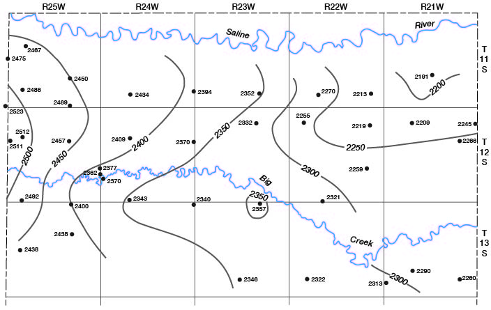
Logs of test holes show that the thickness of the Ogallala Formation in Trego County exceeds 150 feet in some of the thicker sections. The thickness is not uniform, however, because of unconformable contacts at the top and bottom of the Formation. The thickness and character of the Ogallala Formation are shown in the Logs of Test Holes and Wells at the end of this report and are illustrated in the cross sections on Plate 2.
Water Supply
The Ogallala Formation is the most widespread water-bearing formation in Trego County. It supplies water to most domestic and stock wells in the county. In much of the central and northwestern parts of the county, the saturated thickness of the Ogallala is great enough to store fairly large quantities of ground water, from which moderate yields of water are obtained. In the southern part of the county, the Ogallala is either missing or thin and contains little ground water.
A considerable amount of the Ogallala has been removed by erosion along the three principal streams--the Smoky Hill and Saline Rivers and Big Creek (Pl. 2). Few areas in the county have much more than 50 feet of saturated thickness and the saturated thickness of the Ogallala decreases toward the edge of the upland where the Ogallala has been completely drained of ground water. Nevertheless it is estimated that about 700,000 acre-feet of ground water is in storage in the Ogallala in Trego County. Although yields of wells in the Ogallala are not large, it is the most important aquifer in the county because of its wide areal extent.
Neogene System--Pleistocene Series
The classification of Pleistocene deposits by the State Geological Survey of Kansas is based on the classification of glacial deposits in the Midcontinent Region (Frye and Leonard, 1952). Although the nearest glacial deposits are more than 150 miles northeast of Trego County, correlations between the glaciated and nonglaciated areas have been made on the basis of continuous loess deposits, their molluscan fauna and buried soils, and petrologically distinctive volcanic ash (Condra, Reed, and Gordon, 1947; Frye, Swineford, and Leonard, 1948).
Deposits of Pleistocene age, although relatively thin, are the surficial materials in much of Trego County, as shown by the geologic map (Pl. 1) and cross sections (Pl. 2). Pleistocene deposits include the Grand Island Formation and Sappa Formation of Kansan age, the Crete Formation and Loveland Formation of Illinoisan age, the Peoria Formation of Wisconsinan age, and terrace deposits and alluvium of Wisconsinan and Recent age. The Grand Island, Sappa, and Crete formations occur as terrace deposits along the valleys of the Smoky Hill and Saline rivers and along Big Creek valley. Alluvium of late Wisconsinan and Recent age occurs along the inner valleys of the larger streams. Eolian silts classified as the Peoria and Loveland formations cover much of the upland areas and extend along the outer valleys, masking the valley slopes. Pleistocene deposits have been treated in this report as terrace deposits (Crete, Sappa, and Grand Island formations), loess beds (Peoria and Loveland formations), and alluvium (late Wisconsinan and Recent deposits). Figure 6 shows the stratigraphic relation of Pleistocene deposits along the principal valleys.
Terrace Deposits
Terrace deposits shown on the geologic map accompanying this report (Pl. 1) consist chiefly of sand, gravel, and silt deposited during Kansan and Illinoisan times. Terrace deposits along the Smoky Hill Valley are predominantly sand and gravel, whereas terrace deposits along the Saline River and Big Creek valleys contain a relatively greater amount of finer clastic material with silt being predominant in the upper part. Included in the terrace deposits (Pl. 1) are the Grand Island Formation and Sappa Formation of Kansan age and the Crete Formation of Illinoisan age. The Crete and the Grand Island are lithologically similar, both consisting chiefly of arkosic sand and gravel. Stratigraphically, the Sappa Formation lies between the Crete and the Grand Island. The Sappa consists chiefly of silt and sandy silt but locally contains the Pearlette ash bed which identifies it as late Kansan in age. The Crete Formation of Illinoisan age constitutes most of what are called "terrace deposits" in this report. The Crete Formation is spread laterally over a much more extensive area than the underlying Kansan deposits, which are restricted to narrow channels.
Terrace deposits crop out extensively along the Smoky Hill Valley, but they also occur to a lesser degree along the Saline Valley and along Big Creek valley. These deposits are nearly 2 miles wide along much of the Smoky Hill Valley and in places little dissection has occurred in them, particularly along the south side of the valley in the western part of the county. Along the Saline Valley, terrace deposits are mostly remnants, since most of the deposits have been eroded. Along Big Creek valley in the central and western parts of the county, terrace deposits are of narrow width and tend to be obscured because of slope wash from the Ogallala. Along the north side of Big Creek valley in the eastern part of the county, terrace deposits are more than 2 miles wide in places. Where the terrace deposits have not been dissected by erosion, a thin cover of loess mantles them. Although the loess tends to mask the edge of the terrace deposits nearest the upland margin, these terrace deposits are a geomorphologically prominent feature in the major valleys.Grand Island and Sappa Formations
The oldest Pleistocene deposits definitely recognized in Trego County are stream-deposited sand, gravel, and silt classified as the Grand Island Formation and Sappa Formation of Kansan age, although deposits penetrated in test holes 13-21-5bbc and 13-21-8abb may be Nebraskan in age. Along the Smoky Hill Valley, Kansan deposits fill a narrow channel about a quarter of a mile wide. This ancient channel, which has a meander pattern much like that of the modern river, underlies the widespread Crete Formation along much of the terrace extent of the valley, but crops out only locally. In a test hole in the SE cor. NE sec. 27, T. 14 S., R. 21 W., 93 feet of terrace deposits were penetrated, the lower 54 feet of which are classified as the Grand Island and Sappa Formations.
The Grand Island consists predominantly of sand and gravel containing cobbles as much as 4 inches in diameter. The sand and gravel are mostly arkosic but intermixed with the deposits are rounded chalk pebbles and shale fragments. The Sappa Formation consists mostly of silt and sandy silt, but thin lenticular beds of sand and gravel with pebbles of chalk are common. The Sappa is generally very calcareous. It is buff or light gray when fresh but characteristically weathers to very light gray. Locally, a lenticular bed of volcanic ash (Pearlette ash bed) ranging in thickness from a few inches to several feet is found within the Sappa. Outcrops of the Grand Island and Sappa formations occur in small areas along the Smoky Hill Valley.
No outcrops of Kansan deposits were found along the Saline Valley, but test drilling has shown that deposits of Kansan age underlie the Illinoisan terrace surface in a stratigraphic position analogous to that found along the Smoky Hill Valley. In a test hole drilled in the Saline Valley in the SE cor. NE sec. 9, T. 11 S., R. 21 W., 70 feet of terrace deposits were penetrated, the lower part of which is considered to be Kansan in age. Deposits considered to be of Kansan age were penetrated in test holes along Big Creek and underlie the Illinoisan terrace at least locally along Big Creek, especially along the north side of the valley in the eastern part of the county.
Crete Formation
Deposits classified as the Crete Formation of Illinoisan age constitute most of the deposits that underlie the prominent terraces along the major valleys. The Crete Formation consists chiefly of arkosic sand and gravel. A small amount of chalk and shale pebbles and fragments are usually present but are not as common as in the Grand Island. Locally, the upper part of the Crete grades upward into yellow and buff silt and sandy silt classified as the Loveland Formation of late Illinoisan age.
Water Supply
Terrace deposits that border the principal stream valleys are generally continuous with the alluvial deposits that underlie the streams and fill the inner valleys, and the water table in the alluvium is continuous with the water table in the terrace deposits along much of the valleys. Because the terrace deposits overlie bedrock that was not cut as deeply as the incised valley of the present cycle, the saturated thickness of the terrace deposits is not as great as the saturated thickness of the alluvium of the inner valleys.
Terrace deposits yield water adequate for domestic and stock supplies at most places where they occur. In areas where the saturated material is sufficiently thick, moderately large yields from wells can be expected. Test drilling will disclose the more favorable well sites.
Peoria and Loveland Formations
Character, Distribution, and Thickness
Eolian silts (loess) of late Pleistocene age cover a considerable part of Trego County with a relatively thin mantle which tends to subdue the topography in much of the area. The loess caps the rolling hills and flat uplands and masks the gentle slopes of the valleys. It is generally thicker in the northwestern part of the county, where test-hole data indicate the loess may be 25 or 30 feet thick. The loess is shown on the geologic map (Pl. 1) as the Peoria and Loveland formations undifferentiated.
The Loveland Formation is a reddish-tan silt, mostly eolian, which characteristically grades into sand in the lower part. The Sangamon buried soil marks the top of the Loveland Formation and separates it from the overlying Peoria Formation. The Peoria is a massive, eolian, tan to gray silt, which covers much of the upland areas of Trego County.
Colluvial deposits, consisting chiefly of reworked loess, local bedrock fragments, and, in many places, sand and gravel slope wash derived from the Ogallala Formation, constitute much of the surficial material on the slopes of stream valleys and upland draws. Where these colluvial deposits are of sufficient thickness to conceal the underlying rocks they have been included with the Peoria and Loveland formations in this report.
Water Supply
The deposits mapped as Peoria and Loveland formations consist mostly of relatively thin, wind-deposited silts which generally lie above the water table. In parts of Trego County, however, where the Ogallala Formation has been removed by erosion and shallow ground-water supplies are meager, domestic and stock wells obtain small amounts of ground water from colluvial and slope deposits, which in this report are included with the Peoria and Loveland formations. In these areas, the best well sites generally prove to be in creek valleys and draws where thin alluvial and colluvial fill and unconsolidated material overlie the bedrock and serve as local catchment basins. In periods of ample rainfall these wells generally prove adequate for most domestic or stock supplies. During extended periods of dry weather, however, the water drains from much of this material and wells tend to become dry. Because ground water in colluvial deposits is generally in contact with the underlying Cretaceous bedrock and with bedrock fragments that are incorporated within the deposits, the water obtained from these wells is generally of inferior chemical quality.
Alluvium
Character, Distribution, and Thickness
Alluvium classified as late Wisconsinan and Recent in age occurs in relatively narrow deposits along the principal streams in the county. Thick, coarse alluvial deposits of sand and gravel are restricted to the larger valleys and are derived mostly by erosion of older alluvial deposits and from the Ogallala Formation. Thin, poorly sorted deposits of alluvium lie in the smaller valleys and contain relatively less coarse material, the deposits being predominantly silt and fine sand. Deposits in the smaller valleys grade headward into colluvium and slope deposits at the edge of the uplands. The lithology depends largely upon the type of rock into which the valley has been cut.
The alluvium that underlies the stream channels and the narrow floodplains along the principal streams is considered to be Recent in age. Low, relatively narrow terrace deposits, considered to be late Wisconsinan in age, border the floodplain. Although the narrow floodplain and the low terraces are best developed along Smoky Hill Valley, Saline Valley, and Big Creek valley, they are also found to a lesser extent along the smaller valleys. The alluvium of Recent age and the alluvial deposits of late Wisconsinan age underlying the low terraces are lithologically indistinguishable and are shown together as alluvium on Plate 1.
The width and thickness of the alluvium are greatest along Smoky Hill Valley, Saline Valley, and Big Creek valley. It reaches a maximum width of about a mile, but in most places it is less than a half mile in width. The alluvium generally has a thickness of 60 to 70 feet in the deepest part of the valley fill along the Smoky Hill Valley, although one test hole (14-24-35bcc) penetrated 95 feet of it. Alluvium along the Saline Valley and Big Creek valley is 40 to 50 feet thick. Alluvium in the smaller valleys is thin and of narrow extent, and headward these deposits grade into colluvium and slope wash.
Water Supply
Alluvial deposits constitute an important source of ground water in Trego County. Many domestic and stock wells obtain water from the alluvium, and most irrigation wells in the county obtain water from alluvium along the Saline River and Big Creek valleys. Moderate to moderately large yields of water can be expected from wells in alluvium along the Smoky Hill Valley.
Ground-water yields from wells in alluvium in the smaller valleys can be expected to be considerably less than in the larger valleys, because of the finer, less permeable material in the smaller valleys. Since the cross-sectional areas of the smaller valleys are small, water levels tend to fluctuate more in response to rainfall. Declining water levels with subsequent drying up of wells in the smaller valleys and upland draws can be expected during extended periods of below-normal rainfall. In addition because of the relatively shallow depth to water in the alluvium, transpiration by deep-rooted plants during the growing season often results in a decline of water levels.
Prev Page--Ground Water Quality || Next Page--Well Records
Kansas Geological Survey, Geology
Placed on web Dec. 12, 2008; originally published June 1965.
Comments to webadmin@kgs.ku.edu
The URL for this page is http://www.kgs.ku.edu/General/Geology/Trego/07_form.html