![]()
Prev Page--Introduction || Next Page--Geology
Geography
Topography and Drainage
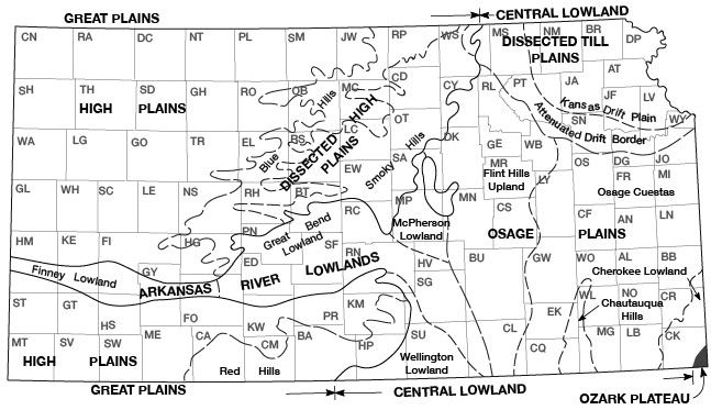
Most of Trego County lies within the High Plains section of the Great Plains physiographic province (Fig. 3) as designated by Schoewe (1949, p. 276). The southeastern corner of the county is in the Blue Hills division of the Dissected High Plains section. Gently rolling uplands that are moderately dissected by smaller drainageways characterize much of the county. Near the major streams, the slopes are quite steep and the topography is rough. Slopes along the north sides of the valleys of the larger streams are relatively more gentle and longer than along the south sides, whereas slopes along the southern sides tend to be cut into steep canyons and badlands. The Fort Hays Limestone Member of the Niobrara Chalk forms prominent escarpments in the southeastern part of the county and along the Smoky Hill Valley. One of the more prominent physiographic features along the Smoky Hill Valley is a high terrace. The surface of the terrace is about 50 feet above the level of the flood plain and about 200 feet below the general level of the upland. Loess and slope wash obscure the outer margin of the terrace in most places.
Figure 3--Map of Kansas showing physiographic regions. (From Schoewe, 1949, fig. 22.)
Three perennial streams cross the county, all flowing in an easterly direction, and are part of the Kansas River drainage system. The Smoky Hill River flows across the southern part of the county, Big Creek across the central part, and the Saline River along the northern edge of the county.
Pediment slopes are characteristic of the outer valleys of the major streams. Along the Smoky Hill River valley, long pediment slopes mask the prominence of the Fort Hays escarpment and grade into the high terrace. Along the Saline River Valley, the pediments are developed on the soft Cretaceous chalk beds and blend into the terrace surface so imperceptibly that the upland edge of the terrace cannot be mapped precisely without subsurface information.
The general slope of the land surface in Trego County is eastward. The total topographic relief is about 600 feet. The lowest elevation, about 2,000 feet above sea level, is in the channel of the Smoky Hill River on the eastern county line in the NE sec. 1, T. 15 S., R. 21 W. The highest elevations are in the uplands in the west-central and northwestern parts of the county and are about 2,600 feet above sea level.
Climate
Trego County has a semiarid continental climate. Low to moderate precipitation, a high rate of evaporation, reasonably mild winters, and fairly hot summers are typical. The hot weather in summer is moderated by brisk winds and low humidity. As a rule the winters are moderate with only short periods of severe cold weather and relatively little snowfall. A large percentage of the winter days are clear, but snow flurries are common, and occasionally the area is subjected to blizzard conditions. In Trego County, the amount of precipitation and its seasonal distribution are the controlling factors in crop growth. Rainfall is erratic, coming sometimes as storms of 4 inches or more, and at other times, in no appreciable amount for several weeks.
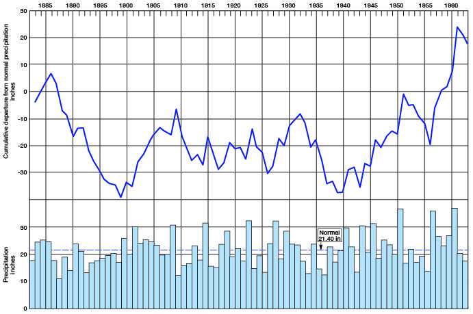
The climatic data in this report were compiled from published records of the U.S. Weather Bureau (U.S. Department of Commerce). Approximately 70 percent of the annual precipitation in Trego County falls during the growing season of about 5 1/2 months (Fig. 4). The mean annual precipitation at WaKeeney is 21.40 inches (based on period of record 1931-55). The greatest annual precipitation recorded was 37.37 inches in 1961; the least was 11.15 inches in 1888. The annual precipitation for the period of record and the cumulative departure from normal precipitation are shown in Figure 5. The average length of the growing season is 167 days, the average date of the last killing frost in spring being April 27, and the average date of the first killing frost in fall being October 11.
Figure 4--Normal monthly precipitation at WaKeeney (1931-1955) and average growing season.
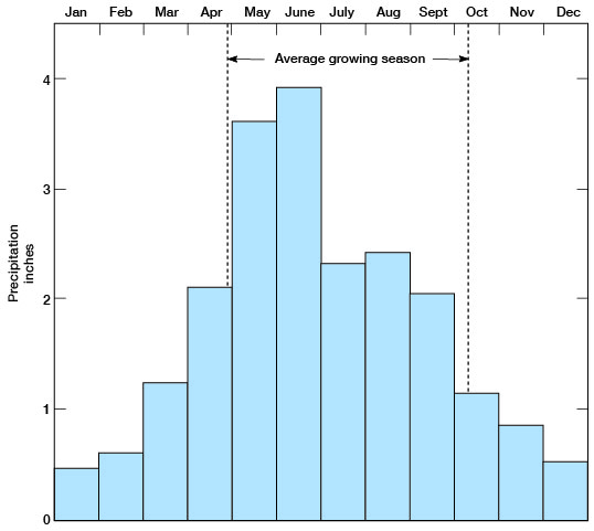
Figure 5--Annual precipitation and cumulative departure from normal precipitation at WaKeeney.
Population
According to the U.S. Census Bureau, Trego County had a population of 5,473 in 1960, of which approximately 50 percent was urban and 50 percent rural. [Note: Trego County population was listed as 3,319 in 2000 U.S. census, with a density of 3.7 (32.9 for the state) (KU Institute for Policy & Social Research).] The County had an average of 6.1 persons per square mile as compared to a State average of 26.6 persons. WaKeeney, the county seat, had a population of 2,808 [1,924 in 2000]. Other communities are Collyer, population 233 [133 in 2000], and Ogallah, unincorporated.
Prev Page--Introduction || Next Page--Geology
Kansas Geological Survey, Geology
Placed on web Dec. 12, 2008; originally published June 1965.
Comments to webadmin@kgs.ku.edu
The URL for this page is http://www.kgs.ku.edu/General/Geology/Trego/03_geog.html