![]()
Prev Page--Geography || Next Page--Economic geology, Ground water
General Geology
Summary of Stratigraphy
[Note: The stratigraphic classification used in this report is that of the State Geological Survey Kansas and may differ somewhat from the classification of the U.S. Geological Survey.]
The rocks that crop out in Trego County are sedimentary in origin and range in age from Cretaceous to Recent. Their areal distribution is shown on Plate 1; their stratigraphic relation is illustrated by cross sections on Plate 2 and in Figure 6. A generalized section of the rock units and their water-bearing properties are given in Table 1.
Figure 6--Stratigraphic relation of Pleistocene deposits across Saline River (A-A'), Big Creek (B-B'), and Smoky Hill River (C-C') valleys. A larger version of this figure is available.
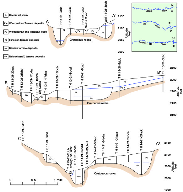
Table 1--Geologic formations in Trego County, Kansas, and their water-bearing properties.
| System | Series | Stratigraphic unit |
Maximum thickness, feet |
Physical character | Water supply | |
|---|---|---|---|---|---|---|
| Neogene | Pleistocene | Alluvium (incl. Recent and late Wisconsinan terrace deposits) | 70 | Stream-deposited silt, sand, and gravel; thick, coarse deposits in major valleys, finer deposits in smaller valleys | Yields moderate to large quantities of water to wells along major valleys; lesser amounts along smaller valleys | |
| Peoria and Loveland formations | 30 | Silt, mostly eolian, sandy in lower part. Mantles most of uplands and masks much of valley walls | Yields small amounts of water to wells locally | |||
| Grand Island, Sappa, and Crete formations (Terrace deposits) | 100 | Stream-deposited sand, gravel, and silt in a terrace position along major valleys. Locally contains Pearlette ash bed | Yields small to moderate quantities of water to wells along major valleys | |||
| Pliocene | Ogallala Formation | 150 | Fluviatile deposits of sand, gravel, silt, and clay; mostly unconsolidated, but cemented at places to various degrees | Yields moderate quantities of water to wells in much of the county | ||
| Cretaceous | Upper Cretaceous |
Niobrara Chalk |
Smoky Hill Chalk Member | 500 | Chalk and chalky shale, thin-bedded and platy; bentonite beds throughout. Light gray to dark gray when fresh; weathers to brown and orange at outcrop | Yields no water to wells |
| Fort Hays Limestone Member | 55 | Massive chalk beds separated by thin chalky shale partings, grayish-white, but may be yellow or light brown at outcrop | Yields small amounts of water to wells locally | |||
| Carlile Shale | 300 | Lower part consists of gray calcareous shale and thin beds of chalky limestone; upper part consists of dark-gray clayey shale with silty fine-grained sandstone lenses in upper part | Yields small amounts of water to wells from Codell Sandstone Member | |||
| Greenhorn Limestone | 100 | Alternating beds of chalky limestone and chalky shale | Yields no water to wells | |||
| Graneros Shale | 45 | Noncalcareous dark-gray shale; persistent bentonite bed in upper part | Yields no water to wells | |||
| Lower Cretaceous |
Dakota Formation | 300 | Clay, shale, siltstone, and sandstone; interbedded and varicolored. Sandstone fine- to medium grained and lenticular. Lignite and "Ironstone" common | Yields small amounts of water to wells | ||
The Carlile Shale of late Cretaceous age is the oldest geologic formation exposed in Trego County. The Carlile crops out along the Smoky Hill Valley east of the junction of the Smoky Hill River and Hackberry Creek and is buried beneath rocks of younger age in the rest of the county.
The Niobrara Chalk of late Cretaceous age overlies the Carlile Shale. The Niobrara crops out along the outer valleys of the Smoky Hill and Saline rivers and their tributaries and along Big Creek valley in the eastern part of the county. The Niobrara Chalk is divided into two members, the Fort Hays Limestone below and the Smoky Hill Chalk above.
The Ogallala Formation of Neogene age (Pliocene) unconformably overlies the Cretaceous rocks in much of the upland areas of the county. Erosion during the Pleistocene Epoch has removed the Ogallala along the Saline and Smoky Hill valleys and in the eastern part of the county along Big Creek valley. Along the Smoky Hill Valley, the Ogallala has been removed along a belt as much as two townships wide, exposing Cretaceous chalk and shale.
Unconsolidated deposits of both fluviatile and eolian origin represent the Pleistocene Series. Fluviatile deposits fill channels cut into Cretaceous bedrock along the principal streams. Eolian deposits mantle the uplands and in many places overlie older terrace deposits along stream valleys. Deposits belonging to the Pleistocene Series are the Grand Island and Sappa formations of Kansan age, the Crete and Loveland formations of Illinoisan age, the Peoria Formation of Wisconsinan age, and alluvium of Wisconsinan and Recent age.
In this report the Grand Island, Sappa, and Crete formations are shown in the illustrations and discussed as terrace deposits, and the Peoria and Loveland formations are discussed together as loess deposits. Figure 6 illustrates the stratigraphic relation of Pleistocene deposits across the principal valleys. Deposits penetrated in test holes 13-21-5bbc and 13-21-8abb, along the north side of Big Creek valley, may be of Nebraskan age.
Unexposed Rocks
Geologic rock units below the Carlile Shale that do not crop out in Trego County but occur in the subsurface within a possible drilling depth for water wells consist of approximately 500 feet of Greenhorn Limestone, Graneros Shale, and Dakota Formation. The Greenhorn Limestone and Graneros Shale are not considered to be aquifers. The Dakota Formation is an important source of ground water for domestic and stock purposes in parts of Trego County. These formations will be discussed further in the section on geologic formations and their water-bearing properties.
Prev Page--Geography || Next Page--Economic geology, Ground water
Kansas Geological Survey, Geology
Placed on web Dec. 12, 2008; originally published June 1965.
Comments to webadmin@kgs.ku.edu
The URL for this page is http://www.kgs.ku.edu/General/Geology/Trego/04_geol.html