![]()
Prev Page--Contents || Next Page--Geography
Introduction
Purpose and Scope of Investigation
This report gives the results of a study of the geology and ground-water resources of Trego County, Kansas. Ground water, although often taken for granted, is one of the most vital natural resources of Kansas. The demand for water and for information concerning its availability has greatly increased in recent years because of an increasing population, accompanied by municipal, industrial, and irrigation expansion, and new water uses in the home and on the farm. The purpose of this investigation was to determine the occurrence, availability, movement, and chemical quality of ground water, and to relate the occurrence of the water to the character, thickness, and distribution of the geologic formations.
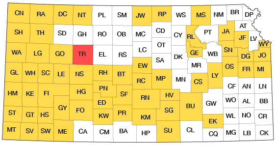
This study was made as a part of the cooperative ground-water program begun in 1937 by the State Geological Survey of Kansas and the U.S. Geological Survey, in cooperation with the Environmental Health Services of the Kansas State Department of Health and the Division of Water Resources of the Kansas State Board of Agriculture. The present status of the program is shown in Figure 1.
Figure 1--Index map of Kansas showing area described in this report and areas covered by other online geologic reports, as of Dec. 2008. For additional information, please visit the KGS Geologic Maps of Kansas Page.
Location and Extent of Area
Trego County is in west-central Kansas, in the third tier of counties south of the Nebraska border and in the fourth tier of counties east of the Colorado border (Fig. 1). It is almost square, extending approximately 30 miles east-west and 30 miles north-south and has an area of about 900 square miles. It contains 25 townships, from T. 11 S. to T. 15 S., and from R. 21 W. to R. 25 W.
Previous Investigations
Cretaceous rocks of Kansas have been a subject of study since the railway explorations and the Meek and Hayden surveys of the 1860's. Adams (1898) has given an historical summary of the early studies of the Cretaceous rocks in Kansas. Haworth contributed reports on the physiography (1897a), the physical properties of Tertiary rocks (1897b), and the geology of underground waters (1897c) in western Kansas. Logan (1897) discussed Upper Cretaceous rocks in western Kansas, and Williston (1897a) described the Niobrara Chalk and discussed the Pleistocene deposits of Kansas (1897b). Johnson (1901, 1902) discussed the Tertiary rocks of the High Plains and ground water in western Kansas. Darton (1905) discussed the geology and ground-water resources of the central Great Plains, in which he treated the loess of western Kansas as a separate formation from the underlying Tertiary deposits. In a special report on well waters in Kansas, Haworth (1913) discussed the Tertiary deposits of western Kansas and their water-bearing characteristics. Russell (1929) studied the stratigraphy and structure of the Smoky Hill Chalk Member in Logan, Gove, and Trego counties and reported on the usefulness of bentonite layers in interpreting the stratigraphy. Elias (1931) studied the geology of western Kansas with emphasis on the Pierre Shale, the Ogallala Formation, and the late Pleistocene deposits. Landes and Keroher (1939) briefly discussed the geology and petroleum resources of Logan, Gove, and Trego counties. A report by Byrne, et al. (1947) describes the occurrence of construction materials in the Cedar Bluff area in Trego County. Frye and Leonard (1952) discussed the Pleistocene geology of Kansas. Ground-water studies in Kansas which border Trego County, or include part of the county, were made by Prescott (1955), Hodson and Wahl (1960), and Leonard and Berry (1961). Areas in Kansas in which ground-water studies have been made, and which are published or are in preparation, are shown in Figure 1.
Methods of Investigation
The writer spent about three months during the summer and fall of 1959 and about three months during the summer and fall of 1960 in the field gathering data upon which this report is largely based. The areal geology was mapped from field observations and from stereoscopic study of areal photographs obtained from the U.S. Department of Agriculture. County maps prepared by the State Highway Commission of Kansas at a scale of one inch to the mile were used to record field data.
Data on 280 wells are given in Table 6 and include the depth to water and the depth of the well. Measurements were made with a steel tape graduated to hundredths of a foot. Measurements in a few wells could not be made and data on depth and water level for these wells were obtained from the owner or driller. Information concerning yield, adequacy of supply, and quality of water was obtained, if possible, from well owners. Drillers' logs of wells and test holes were obtained, if available, from well owners and well drillers.
Logs of 176 test holes and wells are given. Included are 145 sample logs of test holes, 19 logs of test holes obtained from the Bureau of Reclamation, and 4 logs obtained from the State Highway Department. Well drillers and well owners provided logs of 8 wells and test holes.
Locations of wells and test holes within the sections were determined by means of an odometer and from aerial photographs. The altitudes of measuring points of wells and test holes were determined with a plane table and alidade. The base map used for Plate 1 was compiled from maps prepared by the Soil Conservation Service, U.S. Department of Agriculture.
Samples of water from representative wells were collected and were analyzed by Howard A. Stoltenberg, Chief Chemist, in the Sanitary Engineering Laboratory of the Kansas State Department of Health.
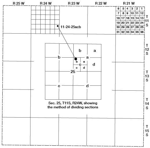
Well-numbering System
The locations of wells, test holes, and local features are designated in this report according to General Land Office surveys in the following order: township, range, section, quarter section, quarter-quarter section, and quarter- quarter-quarter section (10-acre tract). The quarter sections, quarter-quarter sections, and 10-acre tracts are designated a, b, c, or d in a counterclockwise direction beginning in the northeast quarter section. For example, well 11-24-25acb is in the NW SW NE sec. 25, T. 11 S., R. 24 W. (Fig. 2). If more than one well or test hole is located in the same 10-acre tract, the location numbers are followed by serial numbers in the order in which they were inventoried.
Figure 2--Map of Trego County, Kansas, illustrating the well-numbering system used in this report.
Acknowledgments
Thanks and appreciation are expressed to the many residents who gave permission to inventory their wells and who allowed access to their property for the study of rock exposures, to those who permitted aquifer tests to be made using their wells, and to the municipal officials who provided data concerning city water supplies. The Trego County office of the Soil Conservation Service, U.S. Department of Agriculture, located at WaKeeney, gave helpful information.
E. L. and Carrie Reavis and Melvin Franz, of the U.S. Geological Survey and the State Geological Survey of Kansas, gave assistance during field work. The illustrations were drafted by Judy Crissler and Larry Shelton.
The manuscript for this report has been reviewed by members of the U.S. Geological Survey and the State Geological Survey of Kansas; by Robert V. Smrha, Chief Engineer and Harris L. Mackey, Engineer, of the Division of Water Resources of the Kansas State Board of Agriculture; and by J. Lee Mayes, Chief Engineer, and Bruce F. Latta, Geologist, of the Environmental Health Services of the Kansas State Department of Health.
Prev Page--Contents || Next Page--Geography
Kansas Geological Survey, Geology
Placed on web Dec. 12, 2008; originally published June 1965.
Comments to webadmin@kgs.ku.edu
The URL for this page is http://www.kgs.ku.edu/General/Geology/Trego/02_intro.html