![]()
Prev Page--Geology || Next Page--Economic geology, Mineral Resources
Economic Geology
Ground Water
Source
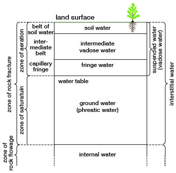
Figure 7 is a diagram of the hydrologic cycle adapted from Piper (1953) showing the part of ground water in the circulation of water near the surface of the earth. The earth's water is constantly circulating from air to ground to air in a process called the hydrologic cycle. Water falls to the ground in the form of precipitation such as rain, snow, sleet, or hall. Part of this water vaporizes and returns to the air by evaporation, a part is removed as runoff via rivers to the ocean, a part percolates into the ground by infiltration, some of which is used by trees and vegetation and is returned to the air through a process called transpiration, and a very small part percolates downward through the soil and underlying strata until it reaches the water table, where it becomes ground water. The hydrologic cycle of rainfall, evaporation, runoff, infiltration and transpiration is continuous. It Is this cycle which provides the source of our ground water. Figure 8 shows the generalized divisions of subsurface water.
Figure 7--Diagram of the hydrologic cycle. Solid flow lines indicate movement of water as a liquid, broken lines, movement as vapor. Heavy flow lines indicate man's principal changes in the natural cycle (after Piper, 1953).
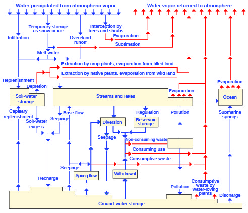
Figure 8--Diagram showing generalized divisions of subsurface water (after Meinzer, 1923, fig. 2).
Where a water-bearing formation is confined between relatively impermeable beds and water is supplied to it from an adjacent area of higher altitude, the water table is absent and the water is said to be confined or under artesian pressure. When an aquifer under artesian pressure is penetrated by a well, water will rise in the well to a height equal to the hydraulic head. The imaginary surface connecting this level in wells is called the piezometric surface, which may or may not be above the land surface. Ground water in the Dakota Formation in Trego County is under artesian pressure, the water rising in some wells as much as 300 to 400 feet above the top of the Dakota. Water in the Codell Sandstone Member rises nearly 200 feet above the top of the Codell in some of the deeper wells in the county. Ground water in the Dakota and in the Codell is discussed further in the section on geologic formations and their water-bearing properties.
The Water Table and Movement of Ground Water
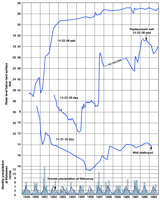
The water table fluctuates up and down in response to additions to or withdrawals from an aquifer. Fluctuations of the water table can be determined by periodic measurements of the depth to water in wells. The depth to water has been measured periodically since 1949 in several wells in the Smoky Hill Valley below the Cedar Bluff dam. These measurements have been published annually by the U.S. Geological Survey (1936-1959) and thereafter by the State Geological Survey of Kansas (1958-1963). Hydrographs in Figure 9 show fluctuations of ground-water levels below the Cedar Bluff dam. The hydrograph of well 14-22-36aab, about a mile below the dam, reflects seepage from the reservoir which was filled in 1951.
Figure 9--Hydrographs showing fluctuations of water levels in the Smoky Hill Valley, and graphs showing monthly and normal precipitation at WaKeeney. A larger version of this figure is available.
The configuration of the water table in the Ogallala Formation in the northern part of the county is shown on Plate 1 by means of contour lines. The direction of ground-water movement is at right angles to the contours and in a downslope direction. The movement is generally eastward, but along the outer edges of the upland the contours bend back reflecting discharge along the edge of the upland. Local anomalies in the water-table contours along the edge of the upland indicate areas of greater recharge due to the predominance of sand and gravel near the land surface where the upland loess has been removed by erosion, exposing the coarser clastic deposits of the Ogallala.
Ground water in the alluvial valleys of the Smoky Hill and Saline rivers is not continuous with ground water in the Ogallala Formation in the uplands but is separated from it by impermeable Cretaceous rocks. Along Big Creek in the central and western parts of the county, however, the water table is continuous with the water table in the Ogallala, and water-table contours show that ground water from the Ogallala is discharging into terrace deposits and alluvium and from there into Big Creek (Pl. 1).
No long-term record of observation wells in the Ogallala Formation in Trego County is available. At the present rate of withdrawal, the water level is fairly stable and ground-water recharge and movement into the county is in equilibrium with discharge and movement from it.
Additions of Ground Water
Additions to the ground-water reservoir may occur in several ways: by direct infiltration of precipitation, by seepage of water from streams, by subsurface inflow of water from adjacent areas, and by infiltration of irrigation water applied to the land.
Infiltration of Precipitation
Approximately 60 percent of the mean annual precipitation in Trego County falls during the months of May through August when the climate is characterized by brisk wind movement, high temperatures, and relatively low humidity. Consequently, evaporation is rapid, and much of the precipitation is returned to the atmosphere. Because much of the rainfall occurs during the growing season, a considerable part of the precipitation is returned to the atmosphere through transpiration of plants.
The topography, vegetative cover, and nature of the subsoil greatly affect the amount of water that will infiltrate below the land surface. The upland areas underlain by the Ogallala Formation are conducive to infiltration of rainfall in areas where sand and gravel crop out. Where thick loess deposits cover the Ogallala, infiltration is retarded.
The alluvium and terrace deposits along stream valleys are very conducive to infiltration because of the sandy nature of the deposits, the low relief, and the shallow depth to water. These deposits, however, are of relatively small areal extent. The annual quantity of recharge by infiltration of precipitation in Trego County is not known, but it is believed to be a small percentage of the total precipitation that falls in the county. Nevertheless, this recharge probably amounts to at least 10,000 acre-feet per year.
Influent Seepage From Streams
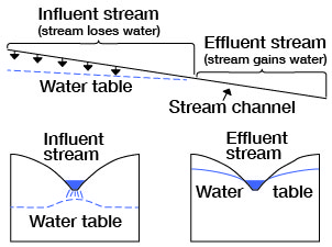
Smoky Hill River, Saline River, and Big Creek are effluent streams in Trego County. Their channels are cut below the water table and thus generally are receiving water from, rather than adding water to, the zone of saturation (Fig. 10). Deposits adjacent to the channels are recharged during flood stages, but the water represents temporary "bank" storage and returns to the stream soon after the flood. Smaller tributaries in the county lie above the water table and during periods of stream flow contribute water to the underlying strata where the channel is underlain by deposits that are conducive to infiltration.
Figure 10--Diagrammatic sections showing influent and effluent streams. Longitudinal section showing (right) how an effluent stream gains water and (left) how and influent stream loses water. Transverse section across influent part of a stream (lower left). Transverse section across effluent part of a stream (lower right). (After Meinzer, 1923, fig. 26.)
Subsurface Inflow
The quantity of subsurface inflow to the county is not known, but it is estimated that from 3 to 4 acre-feet of ground water per day moves into Trego County from the west through the Ogallala Formation (1 acre-foot equals 325,850 gallons). A small amount of ground water enters the county along the northern boundary, chiefly in valleys tributary to the Saline River valley. Some ground water also enters the county by movement in alluvium and terrace deposits along the major stream valleys. Because of the small cross-sectional area of the valley deposits, the amount of ground-water movement in them is relatively small.
Infiltration of Irrigation Water
Recharge from water applied to the land for irrigation has been estimated to approach 25 percent of the applied water in certain irrigated areas. In these areas, the irrigated water is distributed in relatively long ditches over soils and subsoils that are very permeable.
Irrigation in Trego County is confined chiefly to the Big Creek and Saline River valleys where the soils are sandy loam. The percentage of applied water that recharges the alluvium of these valleys is not known but probably is considerable in small local areas. Because irrigation is not practiced extensively and because the areal extent of the alluvial valleys is relatively small, the amount of recharge to the aquifer from infiltration of irrigation water is not significant.
In Trego County, much of the upland plain is thickly mantled by loess and has a relatively dense soil, and recharge probably does not exceed an average of 10 percent of the applied irrigation water. Because only a few irrigation wells obtain water from the Ogallala in Trego County, the amount of recharge to the aquifer from infiltration of irrigation water is considered to be negligible.
Ground-water Discharge
Subtractions from the ground-water reservoir in Trego County include discharge by effluent seepage into streams, discharge of springs, transpiration and evaporation, discharge from wells, and subsurface outflow.
Seeps and Springs
Streamflow is maintained at low stages along the perennial streams in the county by ground-water discharge into the streams, mainly as seeps along stream channels. Discharge is chiefly from alluvial and terrace deposits, but along Big Creek, in the western and central parts of the county, the Ogallala Formation is in contact with the valley deposits and discharge occurs from the Ogallala into the valley deposits. Small springs occur at places where the contact of the Ogallala Formation and underlying Cretaceous rocks crop out. Springs also occur along the edges of the high terrace deposits in the Smoky Hill Valley. The amount of discharge of ground water by springs and seeps in Trego County is not known, but it is believed to be considerable.
Transpiration and Evaporation
Shallow ground water along the major streams supports a heavy growth of vegetation, and during the growing season a significant amount of ground water is transpired by these plants. The quantity of ground water discharged in this manner is difficult to determine, but it probably exceeds the discharge by all other means combined. Transpiration reduces the ground-water discharge into a number of streams, and flow in these streams during the growing season is largely runoff from storms.
After the first killing frost in the fall, perennial streams show an appreciable increase in flow due to a decrease in plant transpiration. In the upland areas transpiration does not occur from the water table because of the greater depth of the water table. Soil moisture lost by transpiration on the uplands, however, must be replaced before any water can infiltrate downward to the water table.
Where the water table is within a few feet of the land surface, ground water may evaporate from the capillary fringe overlying the zone of saturation, or, if the water table is within a few inches of the land surface, water may evaporate directly from the zone of saturation. The evaporation of water from the ground-water reservoir in the county is restricted to the alluvial valleys and the amount is probably small compared to other means of ground-water discharge.
Phreatophytes
Phreatophytes are plants that characteristically grow where they can send their roots down to the water table, or to the capillary fringe, and thus obtain their water supply. Most phreatophytcs are of low economic value, and the water they transpire to the atmosphere is defined as "consumptive waste." More than 70 plant species have been classified as phreatophytes (Robinson, 1958, p. 1), some of the more common being pickleweed, rabbitbrush, salt grass, alfalfa, cottonwood, willow, greasewood, and salt cedar. Salt cedar (Tamarix pentandra) is a serious problem in many stream valleys in the southwestern and western United States. In places, salt cedar has developed a jungle-like growth, invading and choking overflow channels of streams, and producing serious flood hazards. The eradication or control of salt cedar is very difficult and expensive. The annual use of water by salt cedar in areas of heavy growth may be several acre-feet per acre.
Salt cedar has invaded some stream valleys in Kansas and is now found along the Cimarron and Arkansas valleys in southwestern Kansas, Smoky Hill and Saline valleys in west-central Kansas, and South Fork and North Fork Solomon valleys in north-central Kansas (Tomanek and Ziegler, 1963).
Salt cedar has been used extensively as a shelter belt in Trego County and is also found as an ornamental shrub in many farm yards in the county. A number of places around the Cedar Bluff reservoir have become heavily infested with salt cedar. Ecological studies of salt cedar in the Cedar Bluff area (Tomanek and Ziegler, 1963) show that the plant benefits from a drought or conditions that keep the water level falling or low for a long period of time.
Discharge from Wells
Ground water is pumped for municipal, domestic, stock, and irrigation use in Trego County. Municipal water departments in the county reported a total use of about 450 acre-feet of ground water in 1960. Records of the Division of Water Resources of the Kansas State Board of Agriculture show that 3,487 acre-feet of ground water per year were appropriated for irrigation in the county as of April, 1963. The amount of ground water reported as used for irrigation in 1962 was 333 acre-feet. This amount may vary considerably, depending upon rainfall. Most rural residents obtain water for domestic and livestock use from small-diameter drilled wells equipped with cylinder pumps powered by windmills. The yields of these wells are small and probably average about one gallon a minute. Because of their great number and long pumping periods, however, such wells represent an important withdrawal of ground water, estimated to be about 800 acre-feet per year for both household and stock purposes. Withdrawal of ground water from wells is increasing somewhat because of new water uses in the home and on the farm. There is also a small annual increase in the number of irrigation wells in the county, mostly in the alluvial valleys.
Subsurface Outflow
Ground-water contours on Plate 1 show the subsurface flow of ground water to be in a generally eastward direction in the northern part of the county. In most areas the contours bend westward along the edge of the uplands, indicating discharge from the uplands toward the stream valleys. The amount of outflow in the alluvial valleys is small because of the relatively small cross-sectional area of the alluvial valleys. It is estimated that about 700 acre-feet of ground water per year leaves Trego County by subsurface outflow.
Hydrologic Properties of Water-bearing Materials
The quantity of ground water that an aquifer will yield to wells depends upon the hydrologic properties of the material forming the aquifer. The hydrologic properties of greatest significance are the ability to transmit and to store water, which are measured by the coefficients of transmissibility and storage. Controlled aquifer tests in the field provide the data required to compute these coefficients.
The coefficient of transmissibility (T) may be expressed as the rate of flow of water, in gallons per day, through a vertical strip 1 foot wide and extending the full height of the saturated thickness of the aquifer, under a hydraulic gradient of 1 foot per foot, at the prevailing ground-water temperature.
The coefficient of storage (S) may be expressed as the change in the stored volume of water per unit surface area of the aquifer per unit change in the component of head normal to that surface.
The field coefficient of permeability (P) may be expressed as the rate of flow of water, in gallons per day, through a cross-sectional area of 1 square foot, under a hydraulic gradient of 1 foot per foot, at the prevailing ground-water temperature. The field coefficient of permeability can be computed by dividing the coefficient of transmissibility by the aquifer thickness (m).
Determinations of Transmissibility and Permeability
Aquifer tests were made using two irrigation wells, 12-23-20ccc, deriving water from alluvium in Big Creek valley, and 12-23-30acc, deriving water from terrace deposits along Big Creek valley. Details of the wells are given in the table of well records at the end of this report. Observation wells for drawdown measurements were constructed at appropriate distances from the pumped wells. Figures 11, 12, 13, and 14 give the results of these tests. Values of transmissibility were computed from the test data by the methods generally referred to as the Thiem formula, the Theis nonequilibrium formula, the Jacob modified nonequilibrium formula, and the Theis recovery formula. The theory of these formulas and their application are discussed by Ferris, et al. (1962).
Figure 11--Drawdown of water levels in pumped well and observation wells during aquifer test, plotted against time since pumping started (well 12-23-20ccc).
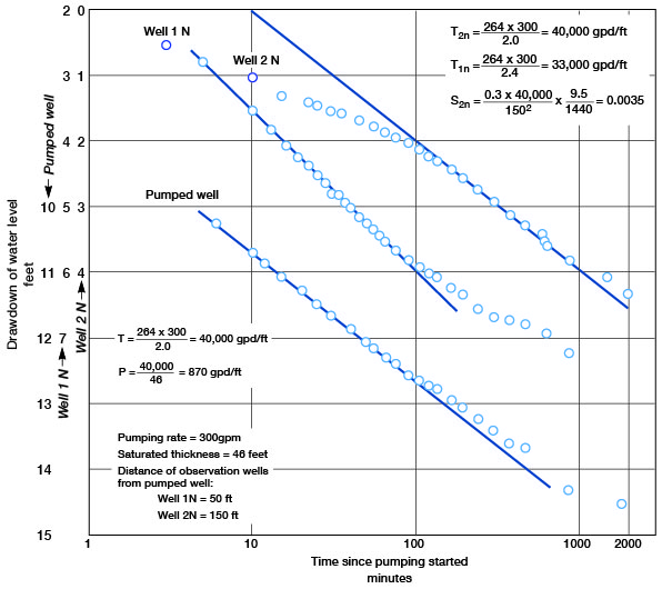
Figure 12--Recovery of water levels in pumped well and observation wells during aquifer test, plotted against time since pumping stopped (well 12-23-20ccc).
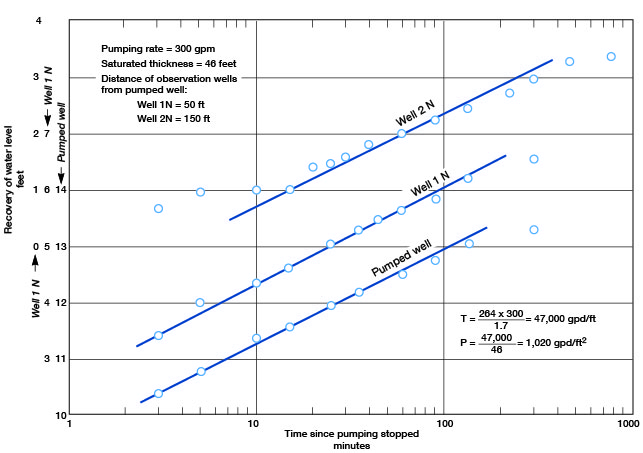
Figure 13--Drawdown of water levels in observation wells during aquifer test at 90 and 1,415 minutes after pumping started, plotted against distance from pumped well (12-23-30acc).
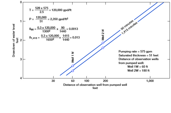
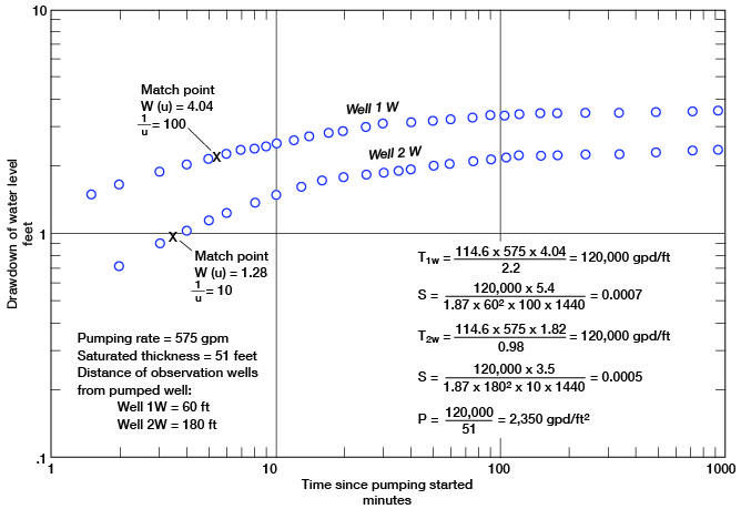
Figure 14--Drawdown of water levels in observation wells during aquifer test, plotted against time since pumping started (well 12-23-30acc).
The aquifer tests indicate that a coefficient of transmissibility of about 40,000 gpd per foot may be expected in the alluvium at localities where the saturated thickness is adequate and where reasonably good sand and gravel beds are in the saturated zone. Test drilling should disclose the more favorable well sites.
Although the aquifer test in the terrace deposits shows a coefficient of transmissibility of about 120,000 gpd per foot, the transmissibility is too high for most deposits shown as terrace deposits in this report. Deposits in the vicinity of well 12-23-30acc are thicker, better sorted, and have a greater saturated thickness than is characteristic of terrace deposits in most of the county. Also, in this area along the central and western reaches of Big Creek, terrace deposits are adjacent to, and in many places lithologically indistinguishable from, the Ogallala Formation. The water table in the terrace deposits is continuous with the water table in the Ogallala Formation and ground water moves from the Ogallala Formation into the terrace deposits. When pumping occurs in the terrace deposits, there is increased movement of ground water from the Ogallala into the terrace deposits toward the area of drawdown. In contrast, along the Saline River and Smoky Hill River valleys and along Big Creek valley in the eastern part of the county, the terrace deposits are separated from the Ogallala by wide areas of impermeable Cretaceous shale.
The coefficients of storage calculated in aquifer test 12-23-30acc (Fig. 13) show a change from artesian to water-table conditions as pumping continued. Logs of test holes in the alluvium and terrace deposits show that silt and clayey silt are characteristic of the upper part of the deposits and that sand and gravel generally occur in the lower part. The silt beds cause a slight artesian effect because of confinement of ground water below these less permeable silt beds.
Utilization of Ground Water
Data on 280 wells in Trego County are given in Table 6. Only part of the domestic and stock wells were visited, but records were made of all municipal and irrigation wells in the county at the time of this investigation. The principal uses of ground water in the county are listed below.
Domestic and Stock Supplies
One of the chief uses of ground water in Trego County is to supply domestic and stock needs. Nearly all domestic and stock supplies in the rural part of Trego County are obtained from wells, but in parts of the county where ground water is difficult to obtain, some stock supplies are provided by dams constructed across small watercourses. Most domestic and stock wells in the county are drilled wells in which casing has been set and which are equipped with displacement-type pumps in which the cylinder is below the water level. Most pumps are operated by windmills; the others are operated by electric or gasoline motors, or by hand.
Municipal Supplies
At the time of this investigation only the communities of WaKeeney and Collyer maintained municipal water-supply systems. Data regarding individual wells and details of well construction are given in Table 6.
WaKeeney--The city of WaKeeney obtains its water supply from seven drilled wells in the alluvial deposits of Big Creek valley about 2 miles south of the city. The wells are equipped with electrically driven turbine pumps; yields range from about 100 to 500 gpm. A reserve well is also maintained at the east edge of town which derives water from the Ogallala Formation. Storage is provided by 2 elevated storage tanks with capacities of 250,000 and 75,000 gallons and 2 underground reservoirs with capacities of 200,000 and 100,000 gallons. Water used in 1960 was about 136 million gallons, as reported by the WaKeeney Water Department.
Collyer--The city of Collyer obtains its water supply from two drilled wells in the Ogallala Formation at the southwest edge of the city. The wells are equipped with electrically driven turbine pumps; yields are about 100 gpm. Storage is provided by an elevated 55,000-gallon tank. An annual use of about 10 million gallons was reported by the Collyer Water Department.
Irrigation Supplies
There were 22 irrigation plants in Trego County by the fall of 1960, most of which were in the alluvial valleys. Nearly all were single wells, but a few plants were pumping from batteries of two or more wells. Yields of the irrigation wells ranged from about 150 gpm to about 1,000 gpm. According to records of the Division of Water Resources of the Kansas State Board of Agriculture, 1,725 acres in Trego County were covered by ground-water rights, or applications for rights, for which 3,487 acre-feet of ground water per year was appropriated, as of April 1963. Surface-water rights, or application for rights, totaled 1,105 acres, for which 2,119 acre-feet of surface water per year was appropriated. This does not include water released from Cedar Bluff reservoir for irrigation districts below the reservoir.
Possibilities of Developing Additional Supplies
Most of the land irrigated with ground water in Trego County is in Big Creek valley. On the assumption that the alluvium and Wisconsinan terrace deposits of Big Creek valley have a average width of a half mile, a length of 30 miles, an average thickness of saturated material of 20 feet, and a specific yield (ratio of the volume of water the saturated part of the aquifer will yield, by gravity, to its own volume) of 15 percent, there would be about 30,000 acre-feet of water in storage, which is 1,500 times the amount of water pumped for irrigation in Big Creek valley in 1962 (as reported to the Division of Water Resources of the Kansas State Board of Agriculture). If pumping were increased enough to lower the water table below stream level, the ground-water reservoir would be recharged from the stream instead of discharging into the stream as it does now. It is estimated that about equal amounts of ground water are in storage in each of the three principal valleys in the county--Smoky Hill Valley, Saline Valley, and Big Creek valley.
About 300 square miles in the northern and central parts of Trego County are underlain by the Ogallala Formation in which the estimated average saturated thickness is about 25 feet. Assuming a specific yield of 15 percent, the ground water in storage in this area would be about 700,000 acre-feet. Not all this water could be pumped from the aquifer, and yields from wells are only moderate to low, but it is an important source of water in the area.
Cedar Bluff Reservoir
Cedar Bluff Reservoir on the Smoky Hill River was filled in 1951 soon after construction of the dam was completed. The height of the dam is 134 feet above the river; its length is 12,560 feet. The reservoir is approximately 9 miles long and nearly 5 miles wide at its widest point. It has a shoreline of about 54 miles at irrigation-pool level. The reservoir has a flood-storage capacity of 191,800 acre-feet and an irrigation-storage capacity of 176,800 acre-feet.
Prev Page--Geology || Next Page--Economic geology, Mineral Resources
Kansas Geological Survey, Geology
Placed on web Dec. 12, 2008; originally published June 1965.
Comments to webadmin@kgs.ku.edu
The URL for this page is http://www.kgs.ku.edu/General/Geology/Trego/05_gw.html