![]()
Prev Page--Introduction || Next Page--Geology
Geography
Topography and Drainage
Schoewe (1949) placed the western part of Clay County in the Smoky Hills division of the Dissected High Plains section of the Great Plains physiographic province and the eastern part of the county in the Flint Hills Upland division of the Osage Plains section of the Central Lowlands physiographic province. The border between the two divisions roughly coincides with the contact between the Cretaceous (Dakota Formation) and Permian (Wellington Formation) rocks through the county. The topography is varied. In the western part of the county, areas underlain with Dakota Formation typically are gently rolling surfaces dotted with numerous mounds or buttes capped by sandstone. East of the outcrop of the Dakota Formation the topography is influenced by the thick shales of the Wellington Formation, which produce a gently rolling surface dissected by streams. Local relief is relatively small. The topography in the easternmost part of the county is dominated by the bedrock of the Chase Group. Here gently rolling uplands contrast with sharp breaks into the valley areas, and the relief is considerably greater than that to the west in the outcrop area of the Wellington Formation. The broad, flat terraces in the valley of Republican River are important for agriculture and ground water.
The highest points in Clay County (about 1,500 feet above sea level) are the hills formed by sandstone of the Dakota Formation a short distance northeast of Oak Hill, and the lowest point (altitude about 1,100 feet) is in the Republican River valley in the southeastern part of the county.
Approximately two-thirds of Clay County lies in the drainage basin of Republican River. The river enters the county near the northwest corner, flows southeastward across the county, and leaves the county a short distance north of the southeast corner. An area of about 50 square miles in northeastern Clay County drains into Fancy Creek and thence into Big Blue River. In southwestern Clay County an area of about 120 square miles drains into Chapman Creek and thence into Smoky Hill River.
Climate
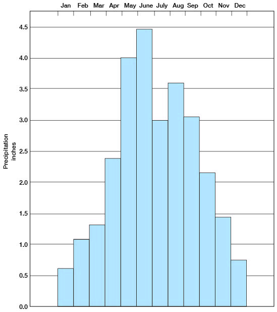
The U. S. Weather Bureau has maintained precipitation and temperature gages at Clay Center since 1902. The normal annual precipitation at Clay Center is 27.92 inches. The annual precipitation and the cumulative departure from normal for the period of record are shown graphically in Figure 3. The precipitation has ranged from a low of 15.57 inches in 1934 to a high of 53.86 inches in 1951. About three-quarters of the precipitation falls during the 6-month period between April 1 and September 30, which is the period most favorable for growing crops. The normal monthly precipitation is shown graphically in Figure 4.
Figure 3--Annual precipitation and cumulative departure from normal precipitation at Clay Center.
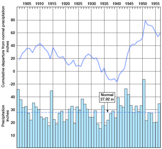
Figure 4--Normal monthly precipitation at Clay Center.
The mean annual temperature at Clay Center is 55.1° F. The growing season in Clay County has ranged from 139 days to 213 days and averages 173 days. The earliest killing frost of record occurred on September 20, 1918; the latest, May 27, 1907.
Population
According to the 1950 census, the population of Clay County was 11,697 and average density was 17.8 persons per square mile as compared with 23.1 per square mile for the entire state. [Note: Clay County population was listed as 8,822 in 2000 U.S. census, with a density of 13.7 (32.9 for the state) (KU Institute for Policy & Social Research).] The census records show that there has been a gradual decline in population in the last 20 years, averaging about 140 persons a year. The urban population has remained about the same since the 1940 census, but the rural population has decreased. The principal cities and their population as shown by the 1950 census are as follows: Clay Center, 4,528 [4,564 in 2000]; Clifton, 365 [557 in 2000]; Green, 219 [147 in 2000]; Longford, 178 [94 in 2000]; Morganville, 278 [198 in 2000]; Oak Hill, 92 [35 in 2000]; Vining, 85 [58 in 2000]; and Wakefield, 591 [838 in 2000].
Transportation
Clay County has good transportation facilities. All but one of the cities are served by one or more railroads. Broughton, Clay Center, Morganville, Clifton, and Vining are served by a branch line of the Chicago, Rock Island and Pacific Railroad Company. Longford and Oak Hill are served by a branch line of the Atchison, Topeka and Santa Fe Railroad Company. Wakefield, Broughton, Clay Center, Idana, and Browndale are served by a branch line of the Union Pacific Railroad. The city of Green was formerly served by another branch line of the Union Pacific, but this line has been abandoned.
Clay County is served by a good state and national highway system. U. S. Highway 24 crosses the county from east to west through Clay Center. Kansas Highway 15 crosses the county from north to south, and Kansas Highway 9 crosses the northwestern part of the county from Kansas Highway 15 west through Clifton. Kansas Highway 82 crosses the southeastern part of the county from Kansas Highway 15 east through Wakefield. All state and federal highways are hard surfaced, as are many of the county highways. Most of the township roads are graded and many of them are all-weather roads.
Agriculture
Agriculture is the principal occupation in Clay County. About 85 percent of the land area in the county is used for agriculture, about one-third pasture and two-thirds cultivated. Wheat is the principal crop and is planted on about half the cultivated land.
The principal crops and the acres harvested in 1955 are as follows: Wheat, 94,000 acres; corn, 22,000 acres; alfalfa, 38,500 acres; sorghums, 21,700 acres; oats, 17,200 acres; and wild hay, 8,500 acres.
Ranking equally in value with grain and hay in the county is livestock products. In order of value these animal products are cattle, poultry and eggs, dairy products, and hogs. The value of livestock, poultry, milk, and eggs in 1955 was about $5,267,000, that of all grains and hay harvested was about $5,225,000 in 1955.
Mineral Resources
Construction Materials
Geologic materials that would be useful in construction projects include the alluvial deposits in the major stream valleys, sandstones and clays of the Dakota Formation, and Permian limestones in the eastern part of the county. For discussion these materials are classified according to use.
Concrete aggregate--Aggregate for concrete consists of fragments of hard, durable minerals or rocks of sand and gravel size. The constituent particles should be free from adherent coatings or particles that would interfere with the bonding of the cement and the aggregate. An almost unlimited quantity of sand and gravel is available from the alluvial deposits in the Republican River valley. Crushed limestone aggregate can be produced in large quantities from the Permian limestones in the eastern part of the county. Material for the manufacture of lightweight aggregate is available from the Dakota Formation and from thin deposits of the Kiowa Shale.
Road metal--Road-surfacing material is available in large quantities from the sand and gravel in the alluvial deposits of the Republican River valley. Sandstone and iron-cemented sandstone of the Dakota Formation can be crushed for road metal and are used extensively in the western part of the county. Crushed limestone from the Permian beds is used extensively in the eastern part of the county.
Mineral filler--Silts from loess deposits of the Sanborn Group and from terrace deposits in the Republican River valley are available and are used in large quantities for mineral filler in road-surfacing material in the county.
Structural stone--Structural stone is any hard dense rock that can be quarried and cut to the desired size and shape. Materials that meet these requirements are found in the Cresswell Limestone member of the Winfield Limestone and the Fort Riley Limestone member of the Barneston Limestone. These limestones are found in the eastern part of the county, and many buildings in the area have been constructed from materials taken from small local quarries.
Agricultural Limestone
Limestone having a calcium carbonate equivalent of 80 percent or more and occurring in ledges sufficiently thick to allow economical quarrying is regarded as a potential source for agricultural limestone. Tn Clay County most of the limestones, especially the Cresswell Limestone member of the Winfield Limestone and the Fort Riley Limestone member of the Barneston Limestone, meet this requirement. Some zones in many of the shales contain enough calcium carbonate to be used for agricultural limestone.
Oil
Oil was discovered in the Wakefield pool in Clay County in 1928. The producing zone was the "Chat" at the top of the Mississippian rocks at a depth of 1,774 feet. After about 2 years the well was abandoned, but in 1951, production was resumed in this pool, and the Wakefield Northeast pool was discovered. In 1952, one well was added to each pool. No production figures are available for Clay County. Of 25 oil tests drilled in the county, 5 have produced some oil. [Current information on the oil and gas resources of Clay County is available from the KGS website.]
Gypsum
Gypsum is not produced commercially in Clay County, although there is a deposit in the NW SW sec. 19, T. 6 S., R. 4 E. Its areal extent is not known, but the geology and topography are such that the gypsum may extend over a considerable area. Unusually high sulfate content of water samples in the area probably indicates the presence of gypsum, though possibly not in commercial quantity. Test hole 6-4-19cb penetrated 13 feet of gypsum, including one seam of clean gypsum 8 feet thick. This deposit rests on the Herington Limestone member of the Nolans Limestone.
Ceramic Raw Materials
By Norman Plummer
Although there is no ceramic industry in Clay County at present, there is available an abundance of clay and shale suitable for use in the manufacture of structural brick and tile, fire brick, and pottery. The most important ceramic clay deposits are in the Dakota Formation, which is exposed in the western and northern parts of the county. Many of the clay deposits in the Dakota Formation fire to light colors ranging from ivory to buff. Most such clays are refractory and could be used for making Low Duty and Intermediate Duty fire brick as well as face brick and pottery. Other clays of the Dakota Formation fire to darker colors ranging from dark buff to deep red (Plummer and Romary, 1947).
Most of the Pleistocene loess deposits of the county are suitable for use in the manufacture of common brick, or as a flux for mixing with the more refractory clays. Such blends are especially suitable for the manufacture of sewer pipe (Frye, Plummer, Runnels, and Hladik, 1949).
Permian shale was at one time used in the manufacture of brick at a plant a short distance southeast of Clay Center. Although acceptable brick can be made from this material, it would be considered inferior in the light of modern standards of brickmaking, and because high-quality raw materials are available it probably would not be used.
The Kiowa Shale of Cretaceous Age, which underlies the Dakota Formation, is an excellent "bloating" shale from which a good grade of lightweight concrete aggregate could be produced.
Prev Page--Introduction || Next Page--Geology
Kansas Geological Survey, Geology
Placed on web April 7, 2009; originally published June 1959.
Comments to webadmin@kgs.ku.edu
The URL for this page is http://www.kgs.ku.edu/General/Geology/Clay/03_geog.html