![]()
Prev Page--Contents || Next Page--Geography
Introduction
Purpose and Scope of Investigation
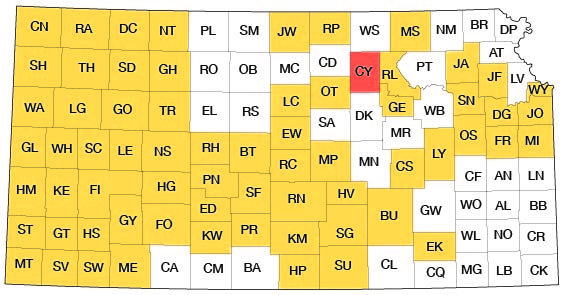
A program of investigation of the ground-water resources of Kansas was begun in 1937 by the United States Geological Survey and the State Geological Survey of Kansas with the cooperation of the Division of Sanitation of the State Board of Health and the Division of Water Resources of the State Board of Agriculture. The investigation of that part of Clay County that lies within the Republican Valley was integrated with the program of the Interior Department for development of the Missouri River basin. The investigation upon which this report is based was begun in the fall of 1953 and field work was completed in the fall of 1955. It is similar to other investigations that have been completed or are being made in other counties in Kansas. The present status of investigations resulting from this program is shown in Figure 1.
Figure 1--Index map of Kansas showing area described in this report and areas covered by other online geologic reports, as of April 2009. For additional information, please visit the KGS Geologic Maps of Kansas Page.
Ground water is one of the principal natural resources of Clay County. Nearly all public, domestic, and industrial water supplies and many stock supplies are obtained from wells. Ground water is being used to some extent for irrigation, and recent interest in irrigation indicates that the use of ground water for this purpose probably will increase greatly in the future. Withdrawal at the present rate has not seriously depleted the ground-water supply or resulted in impairment of the quality of the water by encroachment of water of poor quality, but there is need for an adequate understanding of the quality and quantity of ground water available.
Location and Extent of Area
Clay County is in north-central Kansas, in the second tier of counties south of the Nebraska line and about 50 miles east of the center of the state. The county is bounded on the west by Ottawa and Cloud counties, on the north by Washington County, on the east by Riley and Geary counties, and on the south by Dickinson County; it has an area of 660 square miles.
Previous Investigations
The principal studies of the geology and ground-water resources of north-central Kansas that have a direct bearing on Clay County are cited below. Specific references are cited by author and date at appropriate places in the text; all are listed in the references at the end of the report.
The geology of the Upper Cretaceous rocks in Kansas was described by Logan (1897). Darton (1905) made reference to wells in north-central Kansas in a preliminary report on the geology and ground-water resources of the central Great Plains. Haworth (1913) prepared a report on well waters in Kansas in which he discussed the availability of ground water in the Republican River valley. Jewett (1941) prepared a report on the geology of Riley and Geary counties; in the western part of these counties the geology is very similar to that in eastern Clay County. Plummer and Romary (1947) prepared a report on clay in Kansas in which they described the ceramic characteristics of the clays of the Dakota Formation in the area. Schoewe (1952) in a report on the coal resources of the Dakota Formation described coal reserves in the county. Frye and Leonard (1952) in a report on the Pleistocene geology of Kansas described unconsolidated deposits in the Republican River valley in Clay County.
Methods of Investigation
One month in the fall of 1953, four months in the summer of 1954, and one month in the fall of 1955 were spent in the field collecting the data upon which this report is based. The geology was mapped on aerial photographs from field observations and from stereoscopic study of the photographs. This information was transferred from the photographs to a base map modified from a map prepared by the Soil Conservation Service of the Department of Agriculture.
Data on the character of the water-bearing material, and on the depth, depth to water, and yield of 143 wells were collected (Table 10). Holes were augered with a power auger at 110 locations in order to gather both geologic and hydrologic information. Additional information on the material below the land surface was obtained by drilling 28 test holes with a hydraulic rotary drilling machine owned by the State Geological Survey of Kansas and operated by E. L. Reavis and William Gellinger. Logs of the test holes were prepared in the field, and the drill cuttings were studied microscopically in the laboratory. Altitudes at the surface of the wells and test holes were determined by a level party headed by Mr. Reavis using an alidade and plane table.
Several pumping (aquifer) tests were made to determine the hydraulic characteristics of the water-bearing deposits.
Thirty-three samples (two composite) of water from 35 wells and test holes were collected, and chemical analyses of the samples were made by Howard Stoltenberg, chemist in the Water and Sewage Laboratory of the Kansas State Board of Health (Table 3).
Well-numbering System
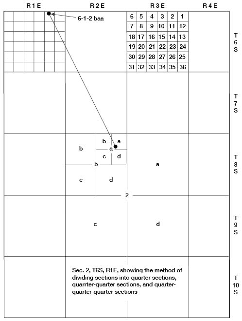
In this report the wells, auger holes, and test holes are numbered according to their location as given by the General Land Office system of land classification. The component parts of a well number are the township number, range number, section number, and two or three lowercase letters that indicate respectively the quarter section, quarter-quarter section, and, if there are three, the quarter-quarter-quarter section in which the well is located. The lowercase letters are assigned to the quarter divisions in a counterclockwise direction, beginning in the northeast quarter of each section or subdivision. For example, well 6-1-2baa (Fig. 2) is in the NE NE NW sec. 2, T. 6 S., R. 1 E. If there are two or more wells in the same quarter-quarter-quarter section they are numbered serially according to the order in which they were inventoried.
Figure 2--Map of Clay County illustrating well-numbering system used in this report.
Acknowledgments
Appreciation is expressed to the many residents of Clay County who supplied information and aided in the collection of field data. Special acknowledgment is due the officials of the cities and industries who provided information about their water supplies. Acknowledgment is made also of information supplied by George Cox, driller, and E. H. Erickerman, irrigation-equipment supplier. F. Turner and H. Rhodes were very cooperative in permitting aquifer tests using their wells. judge Walter O. Curtis of Clay Center was helpful in supplying information about some of the older wells in the area.
The manuscript of this report has been reviewed by several members of the U. S. Geological Survey and the State Geological Survey of Kansas; Robert Smrha, Chief Engineer, and George S. Knapp, Engineer, Division of Water Resources, Kansas State Board of Agriculture; and Dwight Metzler, Chief Engineer, and Willard Hilton, Geologist, Division of Sanitation, Kansas State Board of Health.
Prev Page--Contents || Next Page--Geography
Kansas Geological Survey, Geology
Placed on web April 7, 2009; originally published June 1959.
Comments to webadmin@kgs.ku.edu
The URL for this page is http://www.kgs.ku.edu/General/Geology/Clay/02_intro.html