![]()
Prev Page--Ground water || Next Page--Well Records
Rock Units and Their Water-bearing Properties
Permian System
Wolfcampian Series--Chase Group
Barneston Limestone
In Clay County the Barneston Limestone crops out in the vicinity of Wakefield in the valley walls of Republican River and its tributaries. The Barneston Limestone contains the thickest and most resistant limestone beds in the county, and in the area to the east it is one of the principal scarp-forming rocks of the Flint Hills. In Clay County the Barneston Limestone occupies a fairly low topographic position and does not form a prominent scarp. The members of the Barneston Limestone, in ascending order, are the Florence Limestone, the Oketo Shale, and the Fort Riley Limestone members.
The Florence Limestone member is very easily recognized in Clay County because it is the only rock unit more than a few feet thick that contains a preponderance of chert or flint. The member is primarily a series of beds of limestone and beds of chert. The chert beds are generally of about the same thickness as the limestone beds. At most places a very dark gray or black impure limestone bed about 2 feet thick forms the base of the Florence Limestone member, and a persistent shale bed about 2 feet thick occurs in the upper part of the member. The Florence contains abundant fossils of many varieties. The thickness of the member ranges from 35 to 40 feet.
In Clay County the Oketo Shale member averages about 5 feet in thickness. It is composed chiefly of fossiliferous hard gray calcareous shale.
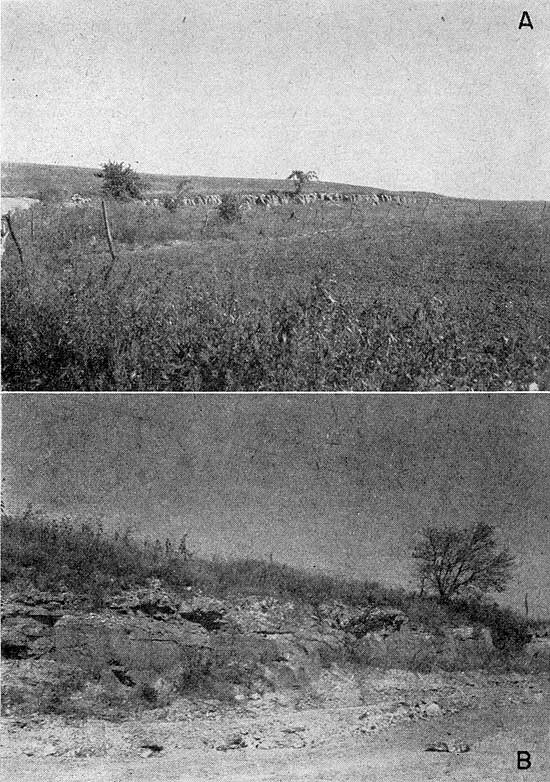
The lower few feet of the Fort Riley Limestone member is composed chiefly of thin-bedded yellow limestone. The limestone beds are overlain by a few feet of gray shale, which is easily confused with the underlying Oketo Shale member unless the Florence Limestone member is exposed also. Next above this shale bed is a massive bed of yellow limestone about 5 feet thick. This bed, which weathers to a pitted surface, is the rimrock, characteristic of nearly all exposures of the Fort Riley Limestone member (Pl. 4A). The rimrock bed is overlain by 15 to 20 feet of thin-bedded sandy yellow limestone and thin calcareous shale beds. In some exposures, a massive bed that has much the same appearance as the rimrock occurs in the upper part of the member. The average thickness of the member is about 35 feet.
Plate 4--A, Rimrock formed by Fort Riley Limestone member, SE NE sec. 27, T. 9 S., R. 4 E.; B, Exposure of Winfield Limestone, SE NE sec 19, T. 10 S., R. 4 E.
Both the Florence and Fort Riley Limestone members are important aquifers in Clay County, but the Oketo Shale member does not yield appreciable quantities of water. A properly constructed well that penetrates the entire thickness of the Barneston Limestone may produce as much as 350 gpm.
In areas where the Barneston Limestone is deeply buried it may yield water that is too mineralized for domestic use. Several wells are known to obtain water of satisfactory quality from the Barneston Limestone at a depth of almost 200 feet, however.
Doyle Shale
The Doyle Shale is composed of two shale members separated by a limestone member--in ascending order, the Holmesville Shale, the Towanda Limestone, and the Gage Shale members.
The Holmesville Shale member consists of 20 to 25 feet of varicolored calcareous shale. Calcite veinlets and thin impure limestone beds are present in the lower few feet of the member in most places.
The Towanda Limestone member is composed chiefly of platy and nodular beds of gray to yellow limestone. In most weathered exposures the member has a very broken and deformed appearance, and the upper limestone beds may be limonite stained and may contain many calcite veinlets. The average thickness of the Towanda Limestone member is about 10 feet.
The Gage Shale member, which in Clay County has an average thickness of about 35 feet, is composed of a lower unfossiliferous varicolored shale and an upper very fossiliferous gray and yellow shale.
The Doyle Shale is not an important aquifer in Clay County, but locally the Towanda Limestone member may yield as much as 5 gpm,to properly constructed wells.
Winfield Limestone
The members of the Winfield Limestone, in ascending order, are the Stovall Limestone, the Grant Shale, and the Cresswell Limestone members.
The Stovall Limestone member consists of a single bed of gray to tan hard cherty limestone about 1 foot thick. It is nonresistant to weathering and is not well exposed in many places. Echinoid spines are the most common fossils in the Stovall. It is easily recognized by its uniform thickness and chert content.
The Grant Shale member has a uniform thickness of about 10 feet in Clay County. It is composed chiefly of tan and gray shale but includes some darker shale in the upper part. It contains many fossil brachiopods, and many quartz geodes are present in the upper part.
The Cresswell Limestone member now includes all the sequence of rocks that in some earlier reports was divided into the Cresswell Limestone member and the Luta Limestone member. The Cresswell Limestone member as now defined consists of a lower massive bed of yellow limestone, containing numerous echinoid spines and other fossils and characterized by pinkish-brown splotches on weathered surfaces, and an upper thin-bedded to concretionary sequence of limestone and shale (Pl. 4B). The thickness of the Cresswell Limestone member in Clay County is about 13 feet.
The Winfield Limestone yields water in quantities sufficient for most domestic and stock supplies, and where the formation is not deeply buried, the water is of good quality.
Odell Shale
The Odell Shale in Clay County consists of about 23 feet of shale. The lower few feet of the shale is principally yellow, and the middle and upper parts of it are mostly red and more calcareous than the lower part.
The Odell Shale does not yield water to wells in Clay County.
Nolans Limestone
The Nolans Limestone includes, in ascending order, the Krider Limestone, Paddock Shale, and Herington Limestone members. The thickness of the formation in Clay County ranges from 18 to 23 feet.
The Krider Limestone member consists of one bed of limestone or of two beds separated by a thin shale bed. The total thickness of the Krider Limestone member is not known to exceed 2 feet. In most places the limestone portion of the member is yellow sandy-appearing nodular limestone containing many fossil brachiopods and pelecypods.
The Paddock Shale member consists of 11 to 13 feet of gray fossiliferous shale.
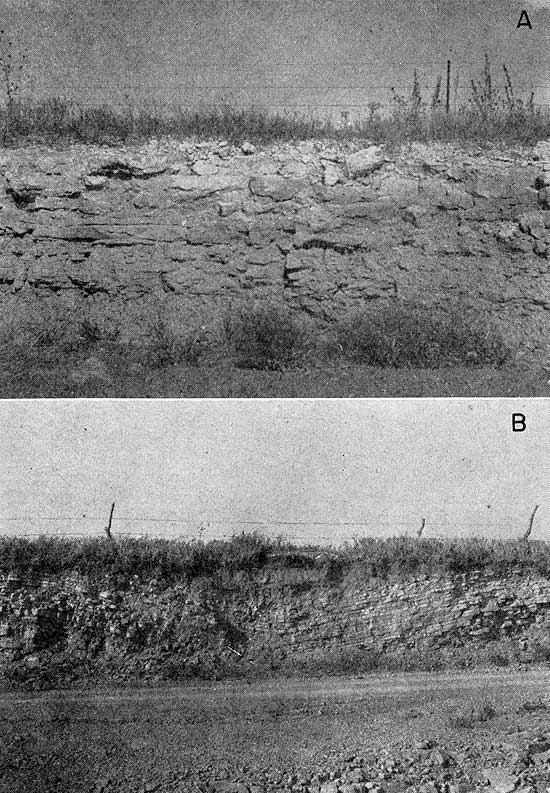
The Herington Limestone member is the most conspicuous part of the Nolans Limestone. Although it is not as resistant to weathering as the Cresswell Limestone member of the Winfield Limestone, the Herington does form an escarpment in favorable topographic situations. In most places the member consists of 6 to 8 feet of yellow to brown, pelecypod-bearing limestone. The upper part is almost everywhere more massive than the lower part of the member (Pl. 5A).
Plate 5--A, Herington Limestone member exposed in road cut, NW sec. 9, T. 9 S., R. 3 E.; B, Hollenberg Limestone member in NW sec. 32, T. 6 S., R. 4 E.
The Nolans Limestone is not a good aquifer in Clay County. The Krider Limestone and Paddock Shale members are not known to yield water. Under favorable conditions the Herington Limestone member might yield some water to domestic and stock wells.
Leonardian Series--Sumner Group
Wellington Formation
The Wellington Formation is not well exposed in Clay County, hence can be described only from observations in other areas and from the interpretation of well logs.
The lower part of the Wellington Formation in Clay County consists chiefly of greenish-gray and red clay shale. Locally, a massive bed of gypsum forms the base of the formation in contact with the Herington Limestone member of the Nolans Limestone. This massive bed of gypsum is well exposed in the southwest bank of a creek about 100 feet east and 300 feet south of the center of the west line of sec. 19, T. 6 S., R. 4 E.
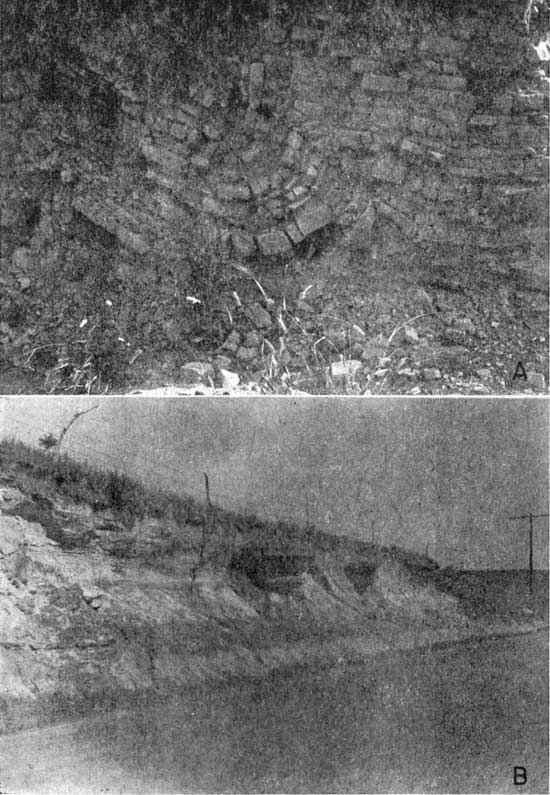
A bed of impure dolomitic limestone, the Hollenberg Limestone member, lies about 40 feet above the base of the Wellington Formation in the northern part of the county. In the area southwest of Broughton the sequence between the Herington Limestone member and the Hollenberg Limestone member may be as thin as 20 feet. The Hollenberg is typically a succession of light-yellow earthy limestone and shale beds, each of which is about 3 to 5 inches thick. In almost every observed exposure in Clay County, the Hollenberg is deformed by many small anticlines and synclines (Pl. 5B) having an amplitude of only a few feet and a distance between crests of about 20 feet. Small-scale faulting also is very common in exposures of the Hollenberg (Pl. 6A). The thickness of the Hollenberg ranges from slightly less than 1 foot to 5 feet.
That part of the Wellington Formation that overlies the Hollenberg Limestone member in Clay County is in general darker than that below. At several widely scattered points a thin discontinuous bed of dark-gray to black chert was found about 12 to 15 feet above the Hollenberg Limestone member. The Hutchinson Salt member, which occurs in the middle part of the formation farther southwest, does not underlie any of Clay County. The greatest thickness of Wellington Formation underlying Clay County is not known, but probably is about 250 feet.
The Wellington Formation yields only very small quantities of water of poor quality to wells in Clay County. One spring (7-3-4da) discharges about 200 gpm of mineralized water from the Wellington Formation.
Plate 6--A, Faulting in Hollenberg Limestone member in NW sec. 32, T. 6 S., R. 4 E.; B, Concretions in Dakota Formation, NE sec. 17, T. 10 S., R. 1 E.
Cretaceous System
Comanchean Series
Kiowa Shale
The base of the Cretaceous rocks is marked by a major unconformity indicated by a cobble zone. The cobbles consist of quartzite, chert, igneous rock, and many types of metamorphic rocks. At many places in Clay County the Dakota Formation rests on the Wellington Formation, the cobble zone being incorporated in the base of the Dakota Formation, and the Kiowa Shale is absent. At a few localities in southern Clay County a dark clay shale resembling the Kiowa crops out at about the contact between the Permian and Cretaceous, but at these localities the cobble zone is not noticeably present at the base of the shale, and the age of the shale is not known. Because the Kiowa Shale was not definitely recognized in Clay County and because of the similarity of their water-bearing characteristics to those of the Wellington Formation, these deposits are included with the Wellington Formation, and the Kiowa Shale is not shown on the geologic map.
Gulfian Series--Colorado Group
Dakota Formation
The Dakota Formation in Kansas consists of two members, the lower Terra Cotta Clay member and the upper Janssen Clay member. The Dakota Formation popularly is believed to consist chiefly of sandstone, but as the member names indicate, clay is the dominant material in most of Kansas. The formation consists entirely of continental or near-shore deposits. Study of surface exposures and test-hole cuttings shows that the formation consists principally of clay of various colors but contains discontinuous beds and lenses of sandstone and siltstone. Minor amounts of pyrite, limonite, hematite, and siderite as concretions (Pl. 6B), thin beds of lignite, and small lenses of quartzitic sandstone are scattered throughout the formation.
In the subsurface most of the sandstone is light gray, but upon being exposed to weathering it becomes yellow, dark brown, or almost red. Some of the sandstone beds are very resistant to weathering and form bold outcrops.
The Dakota Formation is the youngest Cretaceous formation exposed in Clay County, and where it occurs its top is an erosional surface. The thickness of the Dakota Formation in Clay County ranges from a feather-edge to about 165 feet.
The Dakota Formation is one of the principal aquifers in Clay County. The water is generally of good quality. Few wells in Clay County that obtain water from the Dakota Formation yield more than 30 gpm, but it is likely that test drilling in some areas might locate a sufficient thickness of sandstone to yield as much as 100 gpm. Water in the Dakota Formation is under artesian pressure in most parts of Clay County. No flowing wells were observed in the county, but a well flowing from the Dakota Formation is located a few feet west of the county line in Cloud County. Chemical analyses of water from the Dakota Formation are shown in Table 3 and in Figure 8.
Quaternary System
Pleistocene Series
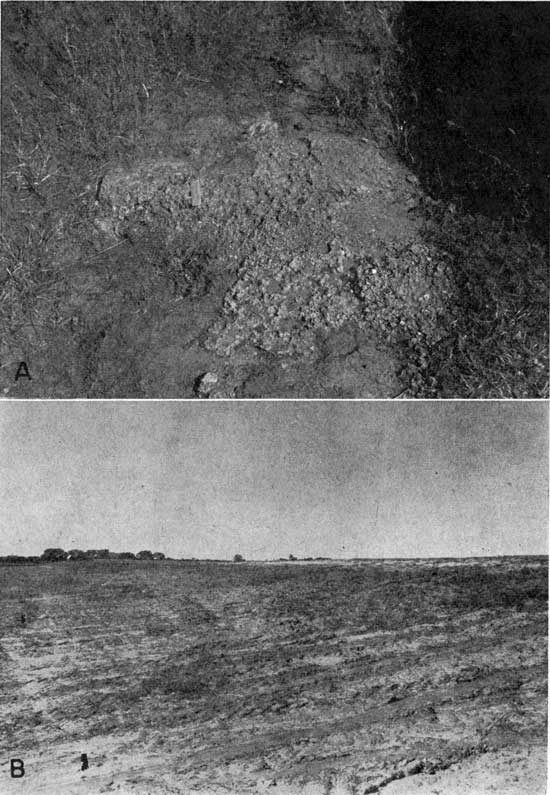
Pleistocene deposits of Nebraskan age possibly are present in Clay County but are unimportant quantitatively. During the first stage of the Pleistocene Epoch there were probably no well-established lines of through drainage, and erosion was the dominant process. Remnants of conglomerate (Pl. 7A), which are exposed in several places in northeastern and south-central Clay County, probably were deposited during Nebraskan or early Kansan time. The conglomerate contains pebbles and fragments of sandstone and limestone derived from Cretaceous rocks and is overlain by loess of Illinoian and Wisconsinan age. These deposits are not known to exceed 4 feet in thickness, and because they cover a very small area they are not shown on the geologic map.
Plate 7--A, Exposure of Pleistocene conglomerate, center south side sec. 10, T. 10 S., R. 2 E.; B, Prominent scarp formed by Wisconsinan terrace, NE sec. 2, T. 6 S., R. 1 E.
Kansan Stage
A few feet of locally derived gravel of probable Kansan age underlies the alluvium of Republican River upstream from Clay Center. Although Republican River did not flow through Clay County during Kansan time, a stream whose headwaters were in the drainage area of what is now White Rock Creek in Jewell County probably flowed where Republican River now has its course through Clay County. In most places this deposit of limestone and sandstone gravel (Grand Island Formation) is 6 to 10 feet thick and in some places is overlain by a few feet of clay of the Sappa Formation.
The water in the basal gravels has about the same quality as that in the overlying Recent alluvium. The Kansan gravel deposits are made up of more angular particles than other valley-fill deposits in the county and probably do not yield as much water as an equal thickness of younger gravel. They do add considerably to the total yield of wells in northwestern Clay County, however.
Illinoian Stage
Terrace deposits--Deposits of Illinoian age in Clay County are represented by the Crete Formation along Republican River and its major tributaries. The Crete Formation in Clay County is in the form of terrace deposits and consists chiefly of silt and clay containing minor amounts of sand and gravel. Nearly all the deposits of the Crete Formation in Clay County are blanketed by a thick covering of Peoria loess, and are not shown on the geologic map. The upper surface of the Crete Formation at most places in Clay County is about 30 to 40 feet above flood plain level.
The Crete Formation in Clay County is generally only partly saturated; however, a bed of locally derived gravel, which is present in many places at the base of the formation, is generally saturated and yields small to moderate supplies of water.
Eolian deposits--Much of the upland area of Clay County as well as the Crete Formation is blanketed with wind-deposited silt commonly known as loess. All the loess in Clay County is included in the Sanborn Group, but only the oldest silt formation, the Loveland Formation, is of Illinoian age. In fresh exposures the Loveland consists of reddish-yellow silt and clay. Most deposits in Clay County are only a few feet thick, and at some localities they are entirely contained within the Sangamon soil, which was developed on the Loveland during the interglacial period between the Illinoian and Wisconsinan glaciers. The Loveland Formation is above the water table and does not yield water to wells.
Wisconsinan Stage
Terrace deposits--Deposits of sand, gravel, and clay locally almost 70 feet thick were laid down along Republican River and other major streams during Wisconsinan time. The streams have subsequently cut to a lower level and these alluvial deposits now form low terraces above the flood plain. These terraces were mapped solely on the basis of topographic expression and probably include both early and late Wisconsinan deposits (Pl. 1).
The Wisconsinan terrace deposits along Chapman Creek and the streams tributary to Republican River are composed chiefly of silt and clay but contain minor amounts of locally derived sand and gravel in the lower part. These deposits yield small to moderate quantities of water to wells, adequate only for domestic or stock use.
The Wisconsinan terrace deposits of Republican River in Clay County are composed almost entirely of arkosic sand and gravel, with the exception of the upper 15 to 20 feet, which in most places is silt and clay. No evidence of a continuous clay bed at the base of the Wisconsinan terrace deposits such as occurs near Concordia, in Cloud County, was found in Clay County. The Wisconsinan terrace deposits lack the hummocky topography typical of the Recent alluvium, and the upper surface of the terrace deposits lies about 12 feet above the upper surface of the alluvium (Pl. 7B). In the area northwest of Clay Center, the Wisconsinan terrace deposits along Republican River yield large quantities of water to wells. Downstream from Clay Center, where the valley is cut through more resistant rocks, the terrace deposits are thinner and more restricted laterally, and the available supply of ground water is somewhat less than in the valley upstream from Clay Center. Water from the Wisconsinan terrace deposits in Clay County is hard but otherwise satisfactory for most uses.
Eolian deposits--Large areas of Clay County are mantled by deposits of loess, or wind-deposited silt, of Wisconsinan age. This silt of the Peoria Formation is contemporaneous with or older than the Wisconsinan terrace deposits. The silt of the Peoria Formation is gray buff and in most places is separated from the underlying reddish-yellow silt of the Loveland Formation by the Sangamon soil. The silt of the Peoria Formation, like all silts, has low permeability and retards the downward movement of rain water, and thus hinders recharge in the upland areas of Clay County. The Peoria Formation lies above the water table and does not yield water to wells.
Recent Stage
Alluvium--Most of the streams of Clay County traverse flood plains underlain by alluvium of Recent age. The alluvium consists predominantly of sand and gravel but includes some silt and clay. The upper surface of the alluvium is characteristically very hummocky and in most places lies about 12 feet lower than the upper surface of the Wisconsinan terraces. Much of the alluvium is covered by water during major floods; it is subjected to erosion in some places, but in other places a small amount of additional material is added. The composition of the alluvium is nearly the same as that of the Wisconsinan terrace deposits, but as the alluvium is somewhat thicker and generally has a greater percentage of saturation, somewhat larger yields of water are obtained from wells in the alluvium.
The quality of the water in the alluvium of Republican River in Clay County is about the same as that of the water in the Wisconsinan terrace deposits. The water is hard but not strongly mineralized.
Dune sand--In an area west of Vining, an area north of Wakefield, and in several smaller areas along Republican River, the wind has piled up sand from the channel and flood plain to form dunes. These dunes are still active in spots, and very little soil has developed on them. The dune areas are composed of many sand hills or dunes interspersed with undrained depressions. The dunes are above the water table and do not yield water to wells, but because of their permeability and lack of drainage they form important recharge facilities for the underlying alluvium and terrace deposits.
Prev Page--Ground water || Next Page--Well Records
Kansas Geological Survey, Geology
Placed on web April 7, 2009; originally published June 1959.
Comments to webadmin@kgs.ku.edu
The URL for this page is http://www.kgs.ku.edu/General/Geology/Clay/06_rock.html