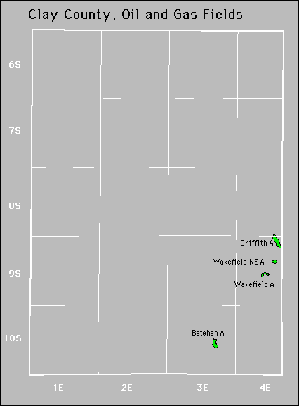
| Year | Oil | Gas | ||||
|---|---|---|---|---|---|---|
| Production (bbls) |
Wells | Cumulative (bbls) |
Production (mcf) |
Wells | Cumulative (mcf) |
|
| 1995 | 3,742 | 2 | 113,450 | - | - | 0 |
| 1996 | 3,700 | 2 | 117,150 | - | - | 0 |
| 1997 | 2,920 | 2 | 120,070 | - | - | 0 |
| 1998 | 3,275 | 2 | 123,345 | - | - | 0 |
| 1999 | 2,928 | 3 | 126,273 | - | - | 0 |
| 2000 | 2,500 | 3 | 128,773 | - | - | 0 |
| 2001 | 2,399 | 3 | 131,172 | - | - | 0 |
| 2002 | 2,419 | 3 | 133,591 | - | - | 0 |
| 2003 | 2,335 | 3 | 135,926 | - | - | 0 |
| 2004 | 2,147 | 3 | 138,073 | - | - | 0 |
| 2005 | 2,681 | 4 | 140,754 | - | - | 0 |
| 2006 | 4,952 | 7 | 145,706 | - | - | 0 |
| 2007 | 8,113 | 10 | 153,819 | - | - | 0 |
| 2008 | 5,294 | 10 | 159,113 | - | - | 0 |
| 2009 | 4,310 | 11 | 163,423 | - | - | 0 |
| 2010 | 3,789 | 10 | 167,212 | - | - | 0 |
| 2011 | 4,279 | 11 | 171,491 | - | - | 0 |
| 2012 | 3,023 | 10 | 174,514 | - | - | 0 |
| 2013 | 2,606 | 5 | 177,120 | - | - | 0 |
| 2014 | 3,903 | 8 | 181,023 | - | - | 0 |
| 2015 | 3,635 | 7 | 184,658 | - | - | 0 |
| 2016 | 2,564 | 6 | 187,222 | - | - | 0 |
| 2017 | 2,083 | 6 | 189,305 | - | - | 0 |
| 2018 | 1,491 | 7 | 190,796 | - | - | 0 |
| 2019 | 2,053 | 7 | 192,849 | - | - | 0 |
| 2020 | 2,671 | 7 | 195,520 | - | - | 0 |
| 2021 | 1,086 | 3 | 196,606 | - | - | 0 |
| 2022 | 1,145 | 6 | 197,751 | - | - | 0 |
| 2023 | 1,400 | 5 | 199,151 | - | - | 0 |
| 2024 | 1,202 | 4 | 200,353 | - | - | 0 |
| 2025 | 335 | 4 | 200,688 | - | - | 0 |


Active
Griffith
Wakefield Northeast
Abandoned