![]()
Prev Page—Physiography || Next Page—Cretaceous, Tertiary
Geology and its Relation to Ground Water
Stratigraphy of Rock Formations
(The stratigraphic nomenclature used in this report is that of the State Geological Survey of Kansas and differs in some respects from that of the United States Geological Survey)
All the rocks that crop out in Barton and Stafford Counties are of sedimentary origin and range in age from Cretaceous to Recent. Outcrops of the formations are shown on Plate 1. The oldest Cretaceous rocks exposed at the surface are lower Cretaceous (Comanchean) in age and comprise part of the Kiowa shale. The Upper Cretaceous (Gulfian) is represented by the Dakota formation, Graneros shale, Greenhorn limestone, and Carlile shale, which are exposed in the upland areas of Barton County. "Algal limestone" in the Ogallala formation of Tertiary age, locally caps Upper Cretaceous formations in parts of Barton County.
Undifferentiated deposits of silts, sands, and gravels of early Pleistocene age are exposed in a comparatively small area in northwestern Barton County. Also unconsolidated deposits of silt, sand, and gravel (Meade formation) of early Pleistocene age cover the eroded surface of the Cretaceous and, in some areas, Permian rocks in southern Barton and all of Stafford Counties. These deposits are exposed along Rattlesnake Creek and the North Fork of Ninnescah Creek in southern Stafford County. Later Pleistocene silts, sands, and gravels (Sanborn formation) underlie parts of the upland in southern Barton County, the Cow Creek drainage basin, and terraces along Walnut and Dry Walnut Creeks. Quaternary dune sand covers the surface in most of Stafford County and southern Barton County, and alluvium underlies the surface of the larger stream valleys and Cheyenne Bottoms.
Information on the unexposed rocks that lie beneath Barton and Stafford Counties has been obtained from test holes drilled during the course of the investigation, from logs of oil and gas test wells, and from exposures of these rocks in other areas. They include sandstones, siltstones, and shales (Cheyenne sandstone) of Lower Cretaceous (Comanchean) age that underlie the Kiowa shale Over most of this area; and Paleozoic limestones, dolomites, and shales with lesser amounts of sandstone, gypsum, anhydrite, and salt that are encountered beneath the Cretaceous deposits.
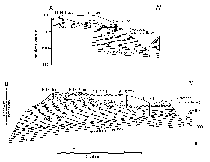
A generalized section of the geologic formations of this area is given in Table 6. The locations of the 106 test holes drilled by the State Geological Survey during the course of the investigation are shown in Figure 9. Geologic cross sections based on these test holes are shown in Figure 10 and Plate 3.
Table 6.—Generalized section of the geologic formations of Barton and Stafford Counties, Kansas. * = Classification of the State Geological Survey of Kansas
| System | Series | Subdivision | Thickness | Physical character | Water supply |
|---|---|---|---|---|---|
| Quaternary | Recent and Pleistocene | Alluvium | 0-125 | Very coarse gravel, sand and silt comprising stream deposits in the larger valleys and Cheyenne Bottoms. Includes deposits underlying low terrace on the north side of Arkansas River and marsh deposits beneath Big and Little Marshes in northeastern Staffor | Yields large amounts of water to wells in Arkansas and Walnut Valleys and small to moderate amounts to wells in Cheyenne Bottoms and smaller stream valleys. Supplies water to many irrigation and a few industrial wells in Arkansas and Walnut Valleys. Water |
| Unconformable on older formations | |||||
| Dune sand | 0-50+ | Fine- to medium-grained wind-blown sand containing minor amounts of silt, clay, and coarse sand. Covers most of the area in Barton and Stafford Counties south of the Arkansas River and a small area on the east side of Cheyenne Bottoms. | Not known to yield water to wells. Areas underlain by dune sand are excellent areas for groundwater recharge from local precipitation. | ||
| Unconformable on older formations | |||||
| Pleistocene | Sanborn formation | 0-138 | Silt, sandy silt, and fine sand that locally contains lenses of coarse sand and gravel. Occurs beneath Cow Creek drainage basin, Cheyenne Bottoms-Arkansas Valley divide area, and Dry Walnut Valley-Arkansas Valley divide area, and includes terrace deposits | Supplies water to domestic and stock wells in the Cow Creek drainage area and the Walnut Valley terrace area. Large supplies available from these deposits locally in Walnut Valley terrace area. Waters from the Sanborn formation are moderately hard to hard | |
| Unconformable on older formations | |||||
| Meade formation | 0-210+ | Interbedded lenses of unconsolidated gravel, sand, and silt. Caliche is common throughout the formation. Meade formation occurs at the surface or at shallow depth beneath dune sand or alluvium over all Stafford County and the southern part of Barton Count | Sand and gravel beds of the Meade formation are the most important sources of water in Stafford County and southern Barton County, and yield large supplies. Most of the domestic and stock wells and all of the irrigation and public-supply wells south of Ar | ||
| Unconformable on older formations | |||||
| Undifferentiated pleistocene deposits | 0-40 | Unconsolidated silt, sandy silt, and clay that contains caliche, and, locally, thin lenses of sand and gravel. Restricted to relatively small area surrounding Galatia in northwestern Barton County. | Supplies water to a few domestic and stock wells in the vicinity of Galatia. | ||
| Unconformable on older formations | |||||
| Tertiary | Pliocene | Ogallala formation | 1-3 | In northern and western Barton County, "algal limestone" from less than 1- to 3-feet-thick caps small hills at widely scattered localities. | Not known to yield water to wells in this area. |
| Unconformable on older formations | |||||
| Cretaceous | Gulfian* | Carlile shale (Fairport chalky shale member) | 85 (?) | Chalky shale and thin beds of chalky limestone, containing thin flat concretions in the lower part. | Furnishes small to meager supplies of hard to very hard water to a few dug domestic and stock wells in northern Barton County. Not an important water bearer. |
| Greenhorn limestone | 85-90 | Chalky tan to blue-gray shale alternating with beds of hard chalk; contains thin beds of hard crystalline limestone in lower part. | Furnishes small to meager supplies of water to a few domestic and stock wells in northern Barton County. Not an important water bearer. | ||
| Graneros shale | 30-40 | Noncalcareous light-gray to blue-gray and brown shale; contains selenite, pyrite, and thin beds of fine-grained sandstone. | Relatively impermeable; not known to yield water to wells in this area. | ||
| Dakota formation | 200-300 | Alternating beds or lenses of varicolored clay, shale, siltstone, and fine- to coarse-grained sandstone. Contains "ironstone" in thin beds, lignite, and a little pyrite. | About a third of the recorded wells in Barton County derive water from sandstones of the Dakota formation. Is the chief source of water in the upland areas of Barton County. Supplies water to city wells at Claflin and Ellinwood. Yields of wells range from | ||
| Comanchean | Kiowa shale | 90-168+ | Light-gray to black shale and sandy shale, containing beds or lenses of fine- to medium-grained sandstone and thin beds of hard calcareous sandstone and sandy limestone. Pyrite, gypsum, shell fragments, and cone-in-cone calcite are common. Exposed in two | Unimportant in this area as a water bearer. One recorded well (20-11-12ad) in Barton County taps sandstone of the Kiowa shale. In most of this area water in the Kiowa is probably highly mineralized. | |
| Cheyenne sandstone | 0-134+ | Sandstone, very fine- to medium-grained, siltstone, and some clay and shale. Not exposed in Barton and Stafford Counties. | No wells in Barton and Stafford Counties obtain water from the Cheyenne sandstone. Scanty data indicate that the water in this formation is highly mineralized and unfit for ordinary uses. | ||
| Permian | Guadalupian and Leonardian* | Undifferentiated red beds | Red siltstone, shale, and sandstone containing lesser amounts of salt, gypsum, anhydrite, limestone, and dolomite. Not exposed in Barton and Stafford Counties. | No wells in Barton and Stafford Counties obtain water from Permian rocks. Water is probably too highly mineralized for most ordinary uses. | |
Figure 9—Location of test holes drilled in Barton and Stafford Counties (numberd circles) and location of geologic cross sections shown in Figure 10 and Plate 3. The numbers shown give the section, quarter section, and quarter-quarter section n which the test hole is located. A larger version of this figure is available.
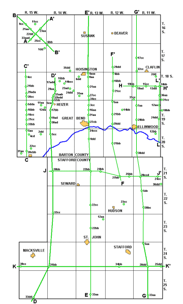
Figure 10—Geologic cross sections of Tertiary deposits in northewestern Barton County, along lines A-A' and B-B' in Figure 9.
Pre-Permian rocks
Pre-Permian rocks are not exposed in Barton and Stafford Counties, and their nearest outcrops are in the eastern part of the state, more than 100 miles east of the area under consideration. Knowledge of the character and distribution of these older rocks in central Kansas has been obtained by various geologists by studying the samples and logs of the deep oil wells that have been drilled in this area. The discussion of the Pre-Permian rocks in Barton and Stafford Counties that is given below is based mostly on data obtained from Wallace Lee (oral communication), geologist of the Federal and State Geologic Surveys, but in part on reports by Moore and Jewett (1942), Koester (1935), and Ver Wiebe (1938).
The oldest rocks encountered by deep drilling are granite, schist, gneiss, and other types of igneous and metamorphic rocks of Precambrian age. These rocks form the "basement" of Kansas, and in Barton and Stafford Counties they are encountered at depths ranging from about 3,500 feet to about 5,000 feet below the surface. Unconformably overlying the Pre-Cambrian "basement" rocks are sandstone, sandy dolomite, and dolomite (Arbuckle group and Lamotte sandstone) of Cambrian and Ordovician age, the oldest sedimentary rocks in this area. They are missing entirely in parts of west-central Barton County and attain a thickness of more than 600 feet in southern Stafford County. The Arbuckle group is one of the most important oil-producing zones in this area.
Rocks of Ordovician age include the Simpson group and the Viola limestone. The Simpson group, which consists of green shale and sandstone, occurs only in the southern half and along the eastern edge of Stafford County where it is generally less than 100 feet thick. Oil has been found in the Simpson group in northeastern and south-central Stafford County. The Viola limestone is found only in the southern two-thirds of Stafford County. It lies on the Simpson group in the southern half of the county and overlaps onto older rocks of the Arbuckle group to the north. The thickness of the Viola limestone in this area is everywhere less than 100 feet and in most places is less than 50 feet. It is an important oil-producing formation in the Stafford-Zenith area.
No strata of Silurian age have been encountered in Barton and Stafford Counties. The Chattanooga shale of Mississippian or Devonian age unconformably overlies the Viola limestone in southeastern Stafford County but is missing elsewhere. The thickness of the Chattanooga shale is 100 feet or less. Mississippian limestone and shale having a thickness of 75 feet or less are present in approximately the southeast quarter of Stafford County. These strata overlie the Chattanooga shale where it is present and overlap the older Viola limestone to the north.
Pennsylvanian rocks, consisting predominantly of limestone and shale, underlie the entire area under consideration. They range in thickness from about 1,200 feet in Barton County to 1,400 feet in southern Stafford County. Their base is marked by a prominent unconformity. In southeastern Stafford County, Pennsylvanian strata lie above Mississippian rocks; in west-central Barton County they lie on Pre-Cambrian rocks; elsewhere, they are found on Cambrian or Ordovician rocks. The Pennsylvanian System includes the important oil-producing rocks of the Kansas City and Lansing groups.
Permian rocks
The Cretaceous rocks, and locally Pleistocene rocks, in Barton and Stafford Counties rest upon an eroded floor of Permian sedimentary rocks-the oldest sediments penetrated in test holes put down during the investigation. Rocks of Permian age are not exposed in this area; their nearest outcrops are to the east in eastern Rice County and southern Reno County. They are encountered in Barton and Stafford Counties at depths ranging from about 75 feet in northeastern Stafford County to 500 feet or more in parts of northern Barton County and are between 1,500 and 2,000 feet thick.
The upper part of the Permian System (Guadalupian-Leonardian Series) is chiefly nonmarine in origin and is composed of red silt-stone, shale, and sandstone with lesser amounts of salt, gypsum, anhydrite, limestone, and dolomite. The salt beds in this area are from less than 50 feet to about 200 feet thick and are encountered about 1,000 feet below the surface (Bass, 1926, p. 90). The lower part of the Permian system (Wolfcampian Series) is largely marine in origin and is composed chiefly of limestone, dolomite, and shale but also contains some sandstone and anhydrite.
No wells obtain water from Permian rocks in Barton and Stafford Counties. Adequate supplies of water are available to wells in most places from rocks overlying the Permian. Furthermore, water obtained from Permian rocks in this area probably would be too highly mineralized f or most ordinary uses. A sample of water collected from test hole 22-11-5dc3, which penetrated Permian rocks in sec. 5, T. 22 S., R. 11 W., northeastern Stafford County, contained 8,688 parts per million of dissolved solids and 4,730 parts of chloride, and had a total hardness of 1,386 parts (analysis 22-11-5dc3, Table 10).
Prev Page—Physiography || Next Page—Cretaceous, Tertiary
Kansas Geological Survey, Barton and Stafford Geohydrology
Web version Dec. 2001. Original publication date Dec. 1950.
Comments to webadmin@kgs.ku.edu
The URL for this page is http://www.kgs.ku.edu/General/Geology/Barton/05_geol.html