![]()
Prev Page—Table of Contents || Next Page—Geography
Introduction
Purpose and Scope of Report
This report presents the results of an investigation of the geology and groundwater resources of Barton and Stafford Counties, which was begun in July 1942, by the United States Geological Survey and the State Geological Survey of Kansas, with the cooperation of the Division of Sanitation of the Kansas State Board of Health and the Division of Water Resources of the Kansas State Board of Agriculture. Owing to the concentration of Survey activities on war work and the shortage of personnel, the field investigation was interrupted and was not completed until the fall of 1944.
The importance of ground water is indicated by the fact that the entire population of Barton and Stafford Counties obtains its water supply from wells. In addition, wells supply water for livestock, for industrial use, and for the irrigation of more than 1,500 acres of land. Thus, there is definite need for an adequate understanding of this important natural resource. The investigation in Barton and Stafford Counties was made to determine the quality, quantity, movement, and availability of ground water.
The investigation was made under the general administration of O.E. Meinzer, geologist in charge of the Ground Water Branch of the Federal Geological Survey until his retirement in November 1946, and under A.N. Sayre, geologist in charge since that time.
The sections on oil and gas and ceramic materials were prepared by geologists of the State Geological Survey.
Location and Extent of the Area
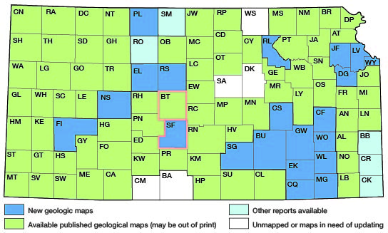
Barton and Stafford are adjacent counties in central Kansas and together they embrace a total of 47 townships containing 1,686 square miles. Barton is the larger of the two counties and has an area of 892 square miles. The location of Barton and Stafford Counties with respect to adjoining counties is shown in Figure 1.
Figure 1—Index map of Kansas showing area described in this report and areas covered by other geologic maps, as of Feb. 2001. For additional information, the KGS Geologic Maps of Kansas Page.
Previous Investigations
A detailed study of the geology and groundwater resources of Barton and Stafford Counties had not previously been undertaken. However, brief references to the geology and ground water of parts of these two counties have been made in numerous reports. In an early paper on the salt deposits of Kansas, Hay (1889, pp. 199, 202) describes the discovery and development of salt near Great Bend in Barton County. A few years later Hay (1893) published a report on the geology and mineral resources of Kansas in which he gives a brief description of the salt marshes in northeastern Stafford County. Physiographic descriptions of the Arkansas River and Cheyenne Bottoms were given by Johnson (1901, pp. 712-713) in his paper on the utilization of the High Plains.
In 1902, Bailey published a special report on the mineral waters of Kansas which includes a description of a deep salt-water well near Great Bend and a chemical analysis of the water from it (Bailey, 1902, p. 197). A preliminary report on the geology and groundwater resources of the Central Great Plains by Darton includes a general description of the water supply in Barton and Stafford Counties (Darton, 1905, pp. 290-291, 319). Brief references to a salt plant at the Big Marsh in northeastern Stafford County and to the quality of water in Cheyenne Bottoms were made by Parker (1911, pp. 47, 55) in a report on the quality of the water supplies of Kansas.
A detailed investigation of the geology of Russell County, adjacent to Barton County on the north, was published by the State Geological Survey in 1925 (Rubey and Bass, 1925). The results of a study of the physiography and geology of south-central Kansas, including all of Stafford County and the southern part of Barton County, are given in an unpublished thesis by Courtier (1934). In 1944, a report was published (Meinzer and Wenzel, 1944, pp. 71-72, 168-171) on water levels and artesian pressures in the United States in 1942, which contains chapters on the observation-well programs in Barton and Stafford Counties. Similar reports have been published for the years 1943-45 (Meinzer and Wenzel, 1946, pp. 63-65, 152-154; Sayre and others, 1947, pp. 51-54, 126-127; 1948, pp. 51-53, 126-128), and additional reports of this series will be published annually.
Cooperative groundwater investigations have been made in several counties adjacent to, or near, Barton and Stafford Counties (Fig. 1). These include reports on Pawnee and Edwards Counties (McLaughlin, 1949), Kiowa County (Latta, 1948), Rice County (Fent, 1950), and the oil-field areas of Russell and Ellis Counties (Frye and Brazil, 1943).
Methods of Investigation
Approximately 3 months in the summer and fall of 1942 and 3172 months in the summer and fall of 1944 were spent by me in the field in Barton and Stafford Counties collecting data for this report. During that time, the wells listed in Tables 12 and 13 were visited and the depths to water in them were measured. All measurements were made with a steel tape from a fixed measuring point at the top of the well. Allan Graffham measured additional wells in Barton County during the fall of 1944. Observation wells in the two counties were established by me and have been measured periodically by W. W. Wilson, Allan Graffham, Melvin Scanlan, and Howard Palmer.
During the course of the field work, the geology of the county was studied and a geologic map (Pl. 1) was prepared. Information concerning the thickness and character of the geologic formations in the subsurface was obtained by the drilling of 104 test holes in the two counties-8O test holes in Barton County and 24 in Stafford County. The test holes were drilled with a hydraulic rotary drilling machine owned by the State Geological Survey and operated by O.S. Fent, Charles K. Bayne, Delmar Berry, George Yeckel, William Connor, Milford Klingaman, and Joseph Votaw. Samples from the test holes were collected and studied in the field by Fent, Bayne, and Berry and were again studied in the office by me. Additional logs of wells and test holes drilled in the two counties were provided by landowners, drillers, and city officials.
The altitudes of the measuring points of those wells that were measured and of the test-hole locations were determined with an alidade and plane table by level parties headed by Richard Tripp and Charles K. Bayne.
Samples of water were collected from 9 wells and 11 test holes and chemical analyses of them were made by Howard Stoltenberg, chemist, in the Water and Sewage Laboratory of the Kansas State Board of Health. In addition, Stoltenberg determined the chloride content of samples of water collected from three wells and two test holes, and of five samples from Rattlesnake Creek, three from Big Marsh, and one from Little Marsh.
Highway maps of Barton and Stafford Counties compiled by the State Highway Commission of Kansas were used. in the field for mapping and were used in the office as base maps in preparing Plates 1 and 2. The drainage was delineated from aerial photographs obtained from the Agricultural Adjustment Administration, United States Department of Agriculture.
Well-numbering System
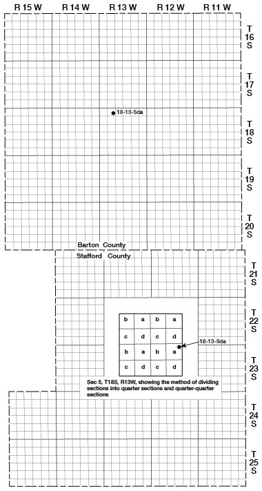
The well and test-hole numbers used in this report give the location of wells according to General Land Office surveys and according to the following formula: Township, range, section, 160-acre tract within that section, and the 40-acre tract within that quarter section. This system of numbering wells is shown on Figure 2. If two or more wells are located within a 40-acre tract, the wells are numbered serially according to the order in which they were inventoried. The 160-acre and 40-acre tracts are designated a, b, c, or d in a counterclockwise direction, beginning in the northeast quarter. For example, well 18-13-5da is located in the NE SE sec. 5, T. 18 S., R. 13 W. As all the area is south and west, respectively, of the base line and meridian used for Kansas, no symbols for south and west are included in the well numbers.
Figure 2—Map of Barton and Stafford counties illustrating the well-numbering system used in this report.
Acknowledgments
Thanks and appreciation are expressed to the many residents of Barton and Stafford Counties who kindly supplied information and aided in the collection of field data. Special acknowledgment is due the officials of the many cities who willingly furnished information about their respective public water supplies. Acknowledgment is also made of the information on the Great Bend water supply received from H. S. Kilby and Clifford Getz, president and manager, respectively, of the Kansas Power Company of Great Bend. The Hines Plumbing Company of Ellinwood, Mr. M. Teichmann of Hudson, Mr. Ben Meyers of Great Bend, and the Layne-Western Company of Kansas City, Missouri, furnished many well records and well and test-hole logs that have been invaluable in this study.
The manuscript for this report has been reviewed by several members of the Federal Geological Survey and the State Geological Survey of Kansas; George S. Knapp, Chief Engineer, and Robert Smrha, Senior Engineer, of the Division of Water Resources, Kansas State Board of Agriculture; and Dwight Metzler, Director and Chief Engineer, and Ogden S. Jones, geologist, of the Division of Sanitation, Kansas State Board of Health. The manuscript was edited by Betty J. Hagerman, and the illustrations were drafted in final form by Robert White and Woodrow W. Wilson.
Prev Page—Table of Contents || Next Page—Geography
Kansas Geological Survey, Barton and Stafford Geohydrology
Web version Dec. 2001. Original publication date Dec. 1950.
Comments to webadmin@kgs.ku.edu
The URL for this page is http://www.kgs.ku.edu/General/Geology/Barton/02_intro.html