![]()
Prev Page—Geography || Next Page—Geology
Physiography
All of the area herein described lies in the Plains border section of the Great Plains province. The total relief of the area is approximately 370 feet. The highest point, about 3 miles northwest of Pawnee Rock in southwestern Barton County, has an altitude of about 2,080 feet, and the lowest point, where Cow Creek leaves the area, has an altitude of about 1,710 feet. Locally, the maximum relief is less than 200 feet.
The area may be divided into seven physiographic divisions, which exhibit differences in topography, drainage, and origin (Fig. 8). These are the Blue Hills upland, Cheyenne Bottoms, Cow Creek drainage basin, Walnut Valley area, Dry Walnut Valley area, Arkansas Valley area, and the Great Bend prairie. Descriptions of each division are given below.
Figure 8—Physiographic divisions of Barton and Stafford Counties, Kansas: (1) Blue Hills upland; (2) Cheyenne Bottoms; (3) Cow Creek drainage basin; (4) Walnut Valley area; (5) Dry Walnut Valley area; (6) Arkansas Valley area; and (7) Breat Bend prairie.
Blue Hills upland
Most of the northern half of Barton County and two smaller areas in the west-central and southwestern parts of the county constitute the Blue Hills upland in this area (Fig. 8). These areas at one time were joined and were part of an extensive plain that extended westward and northward. The upland in northern Barton County is the divide area between the Smoky Hill River and the Arkansas River. It is a well-drained area that has been deeply dissected by many northward- and southward-flowing tributaries. The largest flat areas that remain are only a few square miles in extent.
The upland in west-central Barton County is a narrow spur between Walnut Valley and Dry Walnut Valley. Like the upland in northern Barton County, its surface has been dissected by short streams, resulting in a rugged topography. A third upland area separates Dry Walnut Valley from the Arkansas Valley.
Cheyenne Bottoms
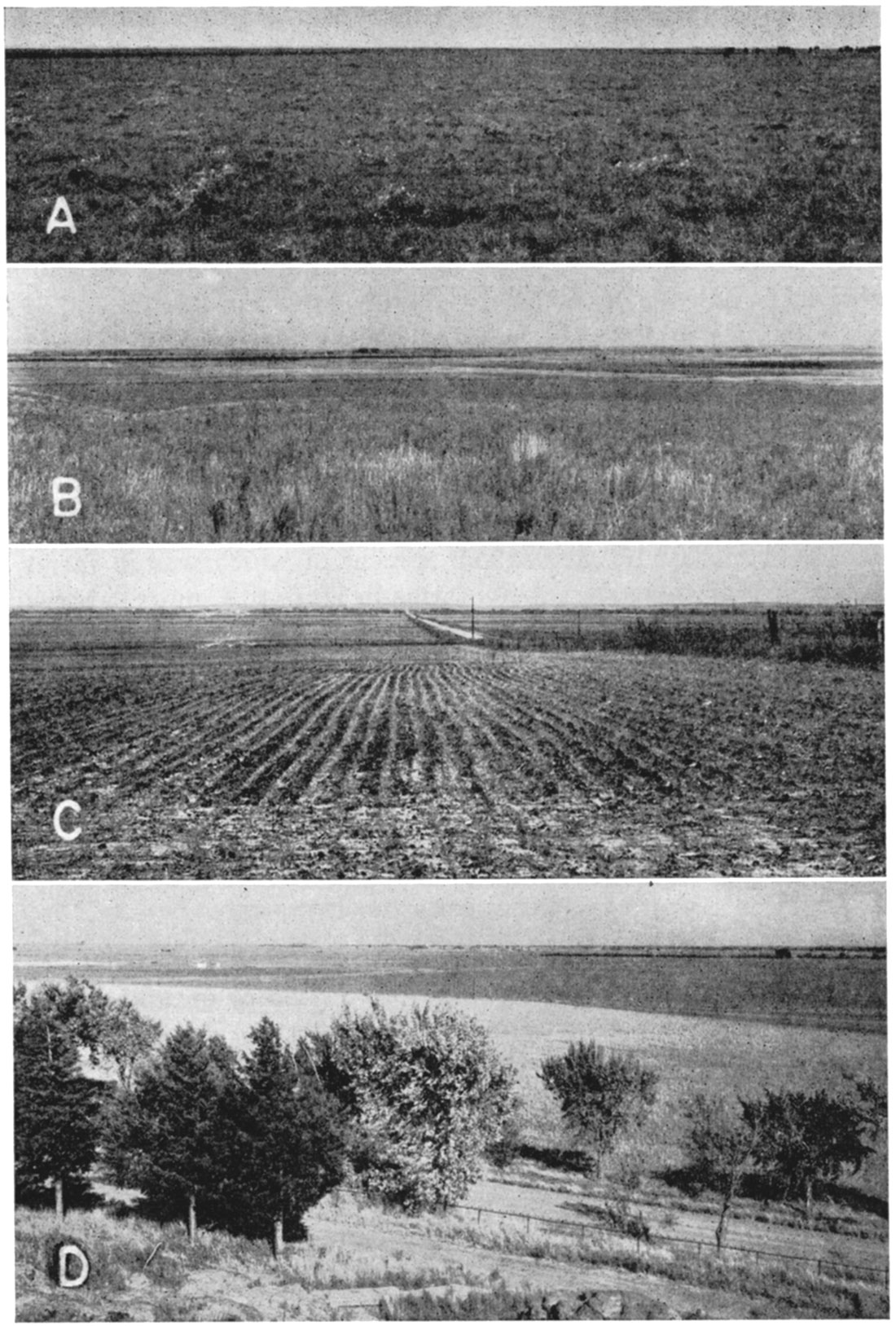
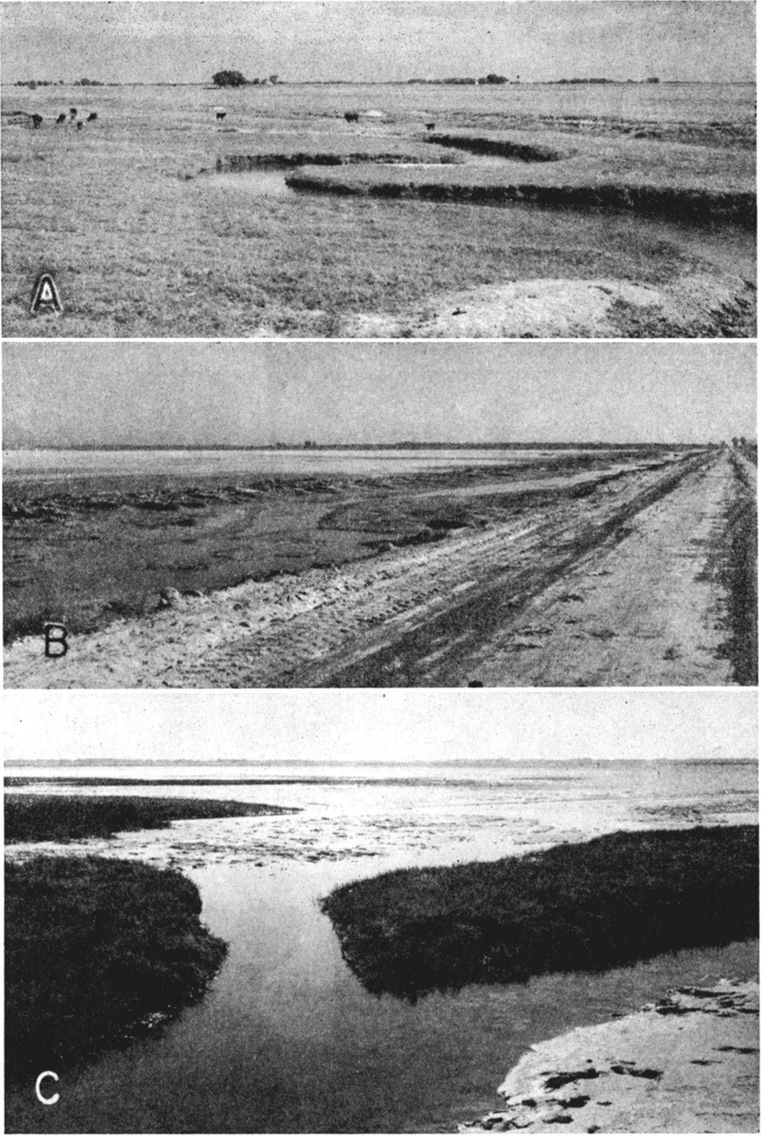
The Cheyenne Bottoms in central Barton County is probably the most interesting physiographic feature in Barton and Stafford Counties, It is a basin that is roughly circular and comprises about 60 square miles. It has a flat, featureless surface that slopes very gently toward the east (Pl. 4, A and B). The bottoms is surrounded on all but the east and southeast sides by steep-sided bluffs composed of sandstone and clay or limestone. The enclosing wall at the east and southeast is composed of dune sand and unconsolidated sand and silt and has gentle slopes.
Plate 4—A, Flat, featureless surface of Cheyenne Bottoms. View looking west from the Cen. W. line sec. 19, T. 18 S., R. 11 W. B, View looking northeast across Cheyenne Bottoms from the S. line sec. 28, T. 18 S., R. 13 W. Dark areas are covered with water. C, View looking south across Walnut Valley terrace from the SW, sec. 8, T. 18 S., R. 15 W., Barton County. Terrace lies between the two dashed lines. The line of trees in the distance marks the course of Walnut Creek. D, Arkansas Valley in western Barton County. View looking downstream from Pawnee Rock.
Blood Creek enters the basin from the west and Deception Creek and an unnamed stream enter from the north. At the southeast is a slightly elevated outlet, Little Cheyenne Creek. Although the elevation of the base of Little Cheyenne Creek is considerably less than that of the adjoining parts of the enclosing wall, it is somewhat greater than the general level of Cheyenne Bottoms. The Kansas Fish and Game Commission and the Federal Wildlife Service have recently acquired title to all the land in the Cheyenne Bottoms and plan to use it as a wildlife-conservation area. It is to be made into a large permanent lake by diverting water from Walnut Creek and Arkansas River into it through a diversion ditch.
Blood Creek originates on the upland in northwestern Barton County, flows southeastward, and enters Cheyenne Bottoms south of Hoisington. Downstream from a point about 10 miles above Cheyenne Bottoms, Blood Creek flows in a relatively flat valley, one-quarter to 1 mile in width, that is bordered by high, steep-sided bluffs capped by resistant sandstone or limestone. Above that point the stream has not yet cut through the limestones of the Greenhorn limestone and Carlile shale and the valley is V-shaped.
Deception Creek and its tributaries are short streams that enter Cheyenne Bottoms from the north. Deception Creek has a peculiarly shaped valley that is unusually wide for its length. The valley is 1 to 1 1/2 miles wide and extends about 4 miles upstream. Its surface is uneven and slopes toward the stream from each side.
Cow Creek drainage basin
This physiographic division comprises the area in east-central Barton County drained by Cow Creek and its tributaries. It is a well-drained area intermediate in level between the uplands on the north and west and the Arkansas Valley on the south. The surface in most of the Cow Creek drainage basin is underlain by soft silt. Erosion of the soft silt by Cow Creek and a well-developed network of tributaries has produced a rolling topography having moderate to gentle slopes (Pl. 5C).
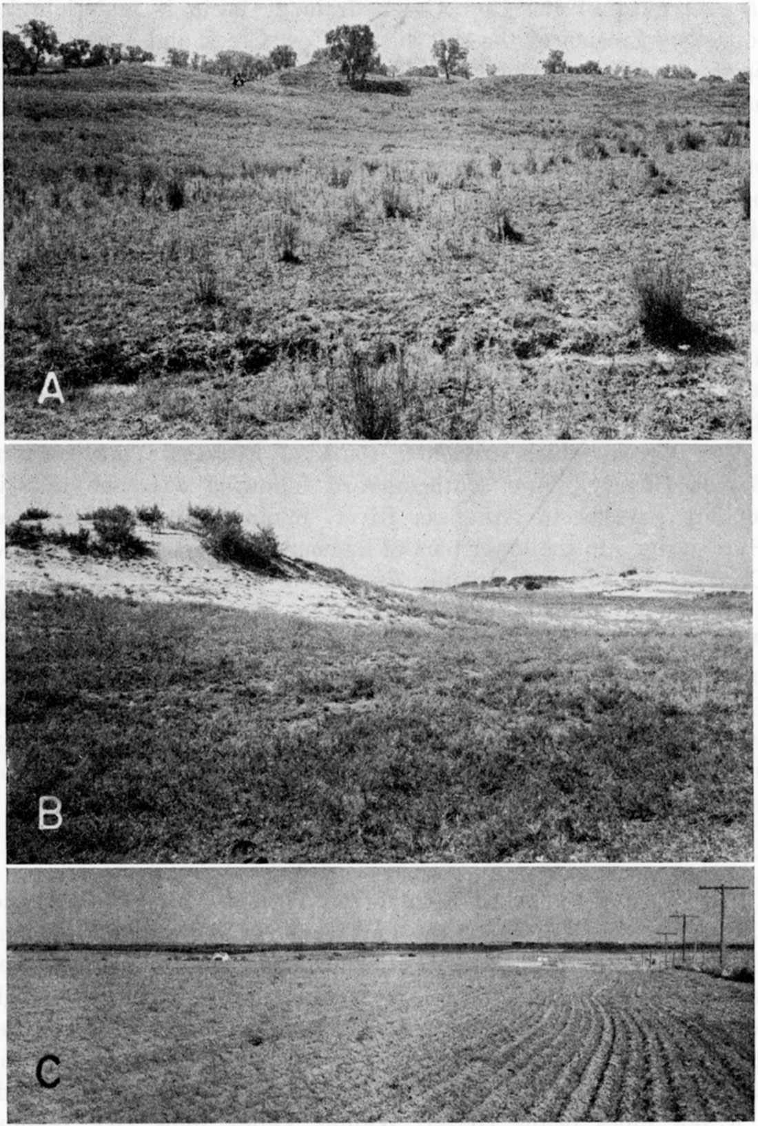
Plate 5—A, Grass-covered sand hills in northeastern Stafford County, looking south from the cen. N. line NW sec. 3, T. 21 S., R. 11 W. B, Bare sand dunes in the NE sec. 30, T. 21 S., R. 11 W., Stafford County. C, View looking east across the Cow Creek drainage basin. The City of Claflin can be seen in the distance at the right. Taken from the SW cor. SE sec. 35, T. 17 S., R. 12 W., Barton County.
Included in this division is the small area of sand hills southwest of Claflin that covers about 8 square miles. The sand hills are bordered on the northwest by the Blue Hills upland and on the west by Cheyenne Bottoms. To the east and south the boundary of the sand hills is not sharp, for there the sand hills merge gradually with the surface of the Cow Creek drainage basin. This area is characterized by typical sand-dune topography having moderate slopes and hills separated by small basins. Its indefinite eastern boundary is shown in Figure 8 by means of a dashed line.
Cow Creek, which originates south of Beaver in northeastern Barton County, flows southeastward following a course that is roughly parallel to Arkansas River, joining Arkansas River at Hutchinson. In the lower part of its course in Barton County, Cow Creek is a perennial stream. Its valley proper consists only of a flood plain and is everywhere less than a quarter of a mile wide. With the exception of Little Cheyenne Creek, all of Cow Creek's tributaries of any size enter from the north. Little Cheyenne Creek heads near the southeast edge of Cheyenne Bottoms and enters Cow Creek on the south side near the Barton-Rice County line. Little Cheyenne Creek is perennial throughout all but the upper 2 to 3 miles of its course.
Walnut Valley area
The Walnut Valley area comprises Walnut Valley proper and a broad terrace bordering the north side of the valley. Walnut Creek originates on the High Plains in Lane County about 85 miles west of Barton County. It follows a general easterly course through Ness and Rush Counties and enters Barton County at about the middle of the west county line. From there it flows east-southeastward and joins Arkansas River 4 miles below Great Bend.
A few miles below Heizer, Walnut Valley joins Dry Walnut Valley and Arkansas Valley to form a wide valley plain in the vicinity of Great Bend. This valley area common to three streams is included in the Arkansas Valley area.
Above this valley plain, Walnut Creek flows in a relatively flat valley that is from about three-fourths of a mile to almost 2 miles in width. Walnut Valley is bordered along its south side by high steep sided bluffs capped by the Greenhorn limestone. A terrace from less than a mile to about 3 miles wide borders the north side of Walnut Valley in Barton County (Pl. 4C). The edge of this terrace lies 10 to 20 feet above the floor of Walnut Valley proper. Its surface slopes gently upward to the north and is terminated in most places by a low but conspicuous bluff formed by the Greenhorn limestone. In some places, particularly in the eastern part of the terrace area, the surface of the terrace merges gradually with the upland surface and there is no distinct topographic break between the two. Most of the terrace area is well drained by tributaries of Walnut Creek, although there are a few flat, poorly drained areas north and northwest of Heizer.
Dry Walnut Creek area
This area includes the valley area occupied by Dry Walnut Creek and its tributaries. Dry Walnut Creek heads in southern Rush County about 10 miles west of the west Barton County line and follows a general easterly course to its junction with Walnut Creek northwest of Great Bend in south-central Barton County. In the lower 9 miles of its course Dry Walnut Creek flows across the Arkansas Valley. Above this point, Dry Walnut Creek occupies a valley about 2 miles wide with many broad reentrant valleys occupied by tributary streams.
The numerous tributaries entering Dry Walnut Creek in this area have formed an uneven valley floor that has a general slope toward Dry Walnut Creek from both sides. Dry Walnut Valley is bordered on both the north and south by low terraces, the surfaces of which have been dissected by many tributary streams.
Arkansas Valley area
The Arkansas Valley area includes the present flood plain of Arkansas River and associated low terraces bordering the flood plain. Arkansas River rises in the Rocky Mountains in central Colorado and follows an easterly course through eastern Colorado and western Kansas to a point in eastern Ford County, where it turns and flows northeastward. The river continues its northeasterly course into southern Barton County, where it again changes direction and flows southeastward. The Arkansas enters Barton County about 5.5 miles east of the southwest corner of the county and leaves the county at a point about 3 miles north of the southeast corner of the county. It reaches its northernmost position midway between Great Bend and Ellinwood, where it is about 6.5 miles north of the south Barton County line. The course of Arkansas River in this area is part of the large and unusual bend it makes in passing from eastern Ford County to Wichita. The average gradient of the river as it crosses Barton County is about 6 feet to the mile.
The width of the Arkansas Valley, including a low terrace along the north side, ranges from about 2 miles at Dartmouth to about 8.5 miles near the east Barton County line. The width of the valley increases from about 3 miles at Pawnee Rock to about 6 miles in the vicinity of Great Bend where the valleys of Dry Walnut Creek and Walnut Creek join the Arkansas Valley. Below Great Bend the valley narrows to about 2 miles at Dartmouth and again widens to about 8.5 miles below Ellinwood. The northern limit of the valley is marked by a distinct bluff except in the area north of Ellinwood where the Arkansas Valley is bordered by the Cow Creek drainage basin (Pl. 4D). The rise from the Arkansas Valley to the surface of the Cow Creek drainage area in many places is so slight that it is difficult to determine the boundary between the two. Sand hills control the southern limit of the valley, where the slopes in general are more gentle than those on the north side.
The terrace included in this division occurs along the north side of the river and lies 5 to 10 feet above the present flood plain. The edge of the terrace, which is nearly everywhere within a mile of the river, is distinct and easily identified from Pawnee Rock to a point about 3 miles above Great Bend and from Dartmouth to the east county line. In the Great Bend-Dartmouth area, where Arkansas River is at its northernmost position, the terrace was not observed. It is possible that the river in this stretch is flowing against the terrace edge.
Great Bend prairie
This physiographic division comprises all the country embraced by the great bend of Arkansas River between Dodge City and Wichita and includes that part of Barton County lying south of Arkansas Valley and all of Stafford County. This region seems low because it is but little above the local base level of Arkansas River. In reality, however, it is an extension of the High Plains and is not low with respect to the country north, south, and east of it. The Great Bend prairie is an alluvial plain which in the greater part of this area has been covered by wind-blown sand.
Except for a relatively small area between St. John and Macksyule and a small area along the North Fork of Ninnescah Creek southwest of Stafford, this region is characterized by typical sand-dune topography having moderate slopes and hills separated by small basins. Some of the hills stand 50 feet or more above the depressions. Much of this sandy region is covered by vegetation and a large part of it is farmed (Pl. 5A). In some parts of the area, particularly in the northeastern and southwestern parts, there are relatively large areas of bare sand that will not support much vegetation (Pl. 5B).
Two salt marshes interrupt the dune topography in northeastern Stafford County. Big Marsh, in T. 21 S., R. 11 W., covers about 16 square miles and is the larger of the two (Pl. 6). The surface of this marsh seems to be flat, but in reality it slopes gently toward an intermittent lake near the center of the marsh (Pl. 7C). The size of this lake depends entirely on the stage of the water table. During dry periods when the water table is low, it is completely dry and its surface is incrusted with a white precipitate (Pl. 7B). During rainy seasons when the water table is high, a shallow lake covering several square miles is formed. Ditches drain part of the marsh area so the water is never more than a few inches deep (Pl. 7B and 7C). Short tributaries lead into the basin of the intermittent lake from the south, west, and north. A ridge of beach sand borders the eastern side of the basin. The only outlet from the basin is in the northeastern part of the marsh area where a short tributary carries the water from the marsh to Rattlesnake Creek.
Plate 6—Aerial mosaic of Big Marsh in northeastern Stafford County. The arrow points north and is about 2 miles long. Point of arrow is about 0.2 mile east of the NE cor. sec. 27, T. 21 S., R. 11 W. (U. S. Dept. Agric. photographs.)
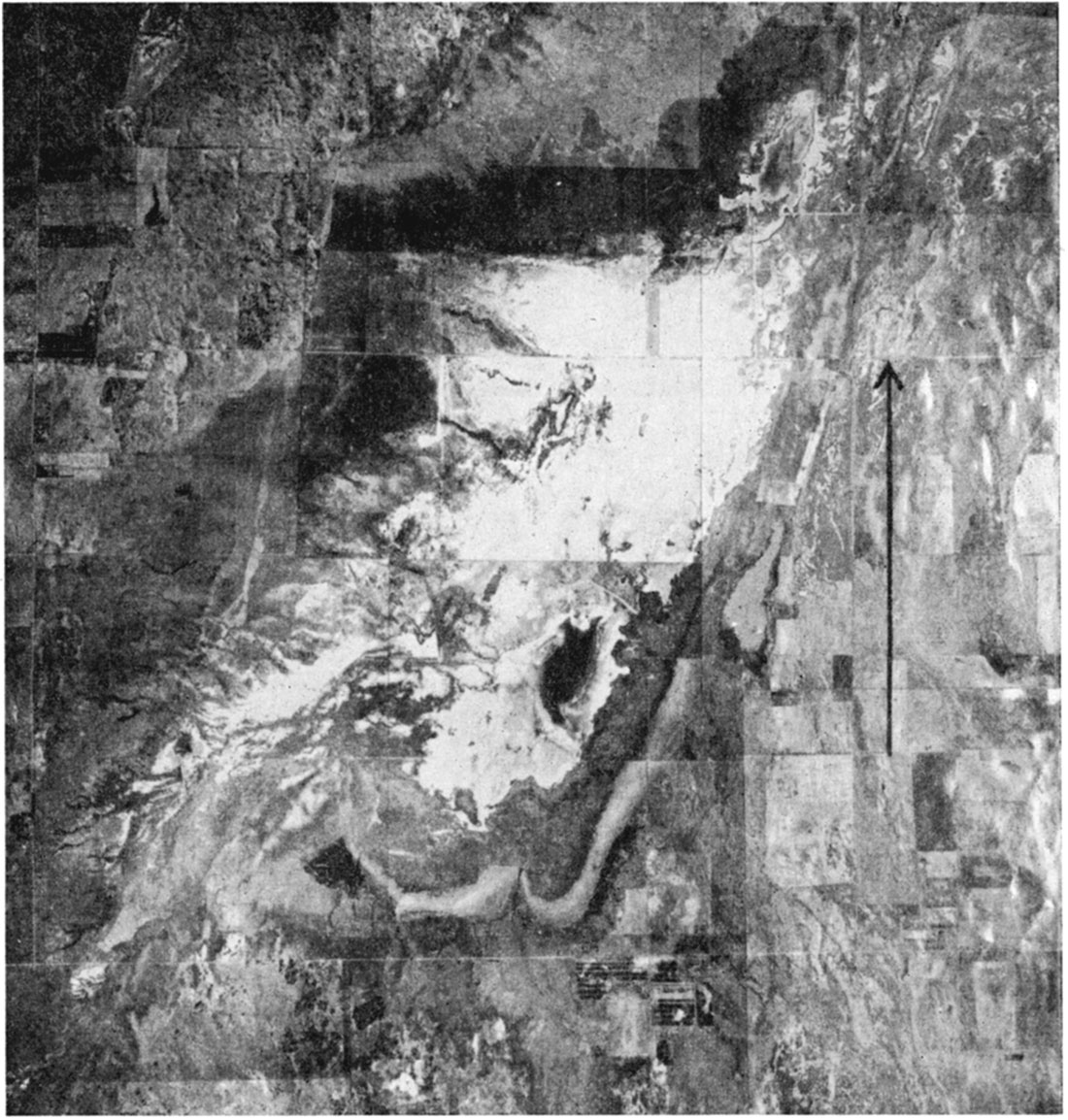
Plate 7—A, Rattlesnake Creek, looking downstream from U. S. Highway 281, about 2.5 miles north of St. John. Note low terrace in right center of view. B, Big Marsh in northeastern Stafford County, looking east from the SW cor. sec. 22, T. 21 S., R. 11 W. Note flat covered with white precipitate in left center of view and the water draining into the road ditch. C, Same as B, but looking southwest.
A smaller marsh occurs about 6 miles southeast of Big Marsh. It is known as Little Marsh and covers about 1 square mile. During wet seasons almost the entire area of this marsh is under water and numerous small hummocks covered by short marsh grasses extend above the water surface. Unlike Big Marsh, this one has no surface outlet.
A relatively small but interesting physiographic feature in this area is the ancient beach ridge that occurs along the east side of the intermittent lake in Big Marsh. It is not a prominent feature from the ground and may be overlooked or confused with a dune ridge by the casual observer visiting this area, but on aerial photographs it is very prominent (Pl. 6). Its chief interest lies in the fact that it represents the shore line of a once more extensive lake. The ridge trends roughly southwest-northeast, is 10 to 15 feet high, and is from about 250 to 900 feet wide. It presents a nearly straight course except at the south where it swings westward around the south end of the intermittent lake. The profile of the ridge in most places is nearly symmetrical and smoothly rounded. A short tributary draw entering the basin from the south and the stream that serves as an outlet at the northeast have cut through the beach ridge dividing it into three segments. The north segment of the ridge is narrow but is fairly distinct. The northern part of the middle segment has undergone more erosion than other parts of the ridge and therefore is less conspicuous.
The Great Bend prairie in general is poorly drained. The rainfall over a large part of this area collects in the numerous basins and hollows where a part of it seeps into the ground and the remainder is lost through evaporation and transpiration. Three streams drain parts of the area—Rattlesnake Creek, Peace Creek, and the North Fork of Ninnescah Creek.
Rattlesnake Creek heads in southern Ford County and follows a general northeasterly course to its junction with Arkansas River in southwestern Rice County. It enters Stafford County near the southwest corner, flows northeast to a point north of St. John, where it turns and flows eastward, passing within a half mile of Little Marsh. Just beyond Little Marsh, near the eastern edge of the county, it abruptly turns and flows north for about 8 miles, where it makes another sharp turn eastward and leaves Stafford County at a point about 2.5 miles south of the northeast corner. The tributary that drains Big Marsh joins Rattlesnake Creek where it makes the bend to the east.
Rattlesnake Creek is a meandering stream that has reached temporary base level (Pl. 7A). Its average gradient above St. John is about 7 feet to the mile and below St. John about 4 feet to the mile. It is a perennial stream from a point a few miles above St. John to where it turns north near Little Marsh; elsewhere it is intermittent. The valley of Rattlesnake Creek ranges from less than half a mile to about 2 miles in width and is bordered throughout most of its course in Stafford County by low, inconspicuous bluffs composed of dune sand. Marsh lands Occupy much of the valley below St. John, especially near the stream, and north of Little Marsh are numerous small intermittent lakes in the valley. The floor of the valley seems to be topographically continuous with the surfaces of both Big and Little Marshes.
Peace Creek is an intermittent stream that heads about 2 miles west of Stafford and flows northeastward, leaving the county about 2 miles south of Little Marsh. It joins Arkansas River southwest of Sterling in southern Rice County. A tributary with several branches rises near the north edge of Stafford and joins Peace Creek half a mile above the county line. Peace Creek and its tributaries flow in narrow valleys bordered by low, inconspicuous bluffs.
The North Fork of Ninnescah Creek heads within half a mile of the south Stafford County line about 12 miles west of the southeast corner of the county, flows northeastward, and leaves the county about 6 miles north of the southeast corner. Except for the upper 4 to 5 miles of its course, it is a perennial stream in this area. Its valley in most places is narrow, with low bluffs having gentle slopes.
Prev Page—Geography || Next Page—Geology
Kansas Geological Survey, Barton and Stafford Geohydrology
Web version Dec. 2001. Original publication date Dec. 1950.
Comments to webadmin@kgs.ku.edu
The URL for this page is http://www.kgs.ku.edu/General/Geology/Barton/04_phys.html