![]()
Prev Page—Introduction || Next Page—Physiography
Geography
Climate
The climate of Barton and Stafford Counties is sub-humid and is marked by extremes of precipitation and temperature. The average growing season in Barton County is about 174 days and has ranged from about 143 to about 220 days. In Stafford County the average growing season is about 169 days and has ranged from about 117 to about 198 days.
The normal annual precipitation at Great Bend and Hudson, determined by the U.S. Weather Bureau, is 24.18 and 24.58 inches, respectively. However, deviations from the normal are frequent. At Great Bend the recorded annual precipitation for the period 1923-47 has ranged from a minimum of 14.72 inches in 1936 to a maximum of 38.35 inches in 1944, and at Hudson it has ranged from 14.17 inches in 1936 to 34.54 inches in 1944. The annual precipitation for the period of record and the cumulative departure from normal precipitation at Great Bend and Hudson are shown graphically in Figures 3 and 4.
Population
According to the 1945 census by the State Board of Agriculture the population of Barton County was 26,597 and the population of Stafford County was 9,288, a total of 35,885 for both counties. Great Bend, the largest city in the area and the county seat of Barton County, had a population of 10,065 in 1945. Other towns in Barton County and their 1945 populations are Hoisington, 3,875; Ellinwood, 2,141; Claflin, 708; Pawnee Rock, 339; Albert, 166; Galatia, 124; and Olmitz, 145.
The largest town in Stafford County is Stafford, which had a population of 1,969 in 1945. St. John, population 1,614, is the second largest town and the county seat. Other towns in Stafford County and their 1945 populations are Macksville, 540; Hudson, 235; Seward, 130; and Radium, 76.
Population figures are not available for the small towns of Beaver and Heizer in Barton County, or Zenith in Stafford County. Redwing, Dartmouth, and Farhman, in Barton County, and Neola, in Stafford County, serve as supply stations for farmers and as grain-shipping points.
Transportation
Barton and Stafford Counties have excellent transportation facilities. The main line of the Atchison, Topeka, and Santa Fe Railway traverses Stafford County from east to west through Zenith, Stafford, St. John, and Macksville. An alternate route of the Atchison, Topeka, and Santa Fe Railway between Hutchinson and Kinsley passes through Ellinwood, Great Bend, and Pawnee Rock in southern Barton County. The main line of the Missouri Pacific Railway traverses central Barton County from east to west through Claflin, Redwing, Hoisington, and Olmitz.
A branch line of the Missouri Pacific Railway running from Kingman to Lamed passes through Stafford, Hudson, Seward, and Radium in Stafford County. Another branch line of the Missouri Pacific runs between Great Bend and Hoisington. A branch line of the Atchison, Topeka, and Santa Fe Railway runs from Great Bend westward to Scott City, passing through Heizer and Albert in west-central Barton County. Another branch line of the Santa Fe runs from Galatia in northwestern Barton County through Susank, Beaver, and Fahrman to McPherson in McPherson County.
Several hard-surfaced Federal and State highways pass through Barton and Stafford Counties. U.S. Highway 281 crosses the central part of the area from north to south, passing through Hoisington, Great Bend, and St. John. U.S. Highway SON passes from east to west through Ellinwood, Great Bend, and Pawnee Rock in southern Barton County, and U.S. Highway 505 passes from east to west through Zenith, Stafford, St. John, and Macksville in southern Stafford County. State Highway 4 traverses central Barton County from east to west, passing through Claflin and Hoisington. State Highway 96 runs northwest from Great Bend through Heizer and Albert, and State Highway 19 passes from east to west through
Radium and Seward, joining U.S. Highway 281 at a point 2 miles east of Seward. Numerous improved county and township roads serve the remainder of the area (Pl. 1).
Agriculture
Agriculture is the dominant economic activity in Barton and Stafford Counties, wheat being by far the most important crop. Other crops include corn, grain sorghums, barley, oats, rye, and alfalfa. The acreage of the principal crops grown in Barton and Stafford Counties in 1948, as reported by the Kansas State Board of Agriculture, is given in Table 1.
Table 1—Acreage of principal crops grown in Barton and Stafford Counties, Kansas, in 1948
| Crop | Barton County | Stafford County |
|---|---|---|
| Wheat | 262,000 | 196,000 |
| All hay exclusive of sorghums | 36,180 | 40,510 |
| Sorghums | 29,860 | 40,940 |
| Oats | 11,560 | 3,970 |
| Barley | 9,520 | 4,560 |
| Corn | 2,000 | 3,100 |
| Rye | 290 | 1,080 |
Barton County has a total land area of about 570,880 acres. According to the 1940 census, 98.8 percent of the land was in farms. In 1948 there were 1,522 farms in Barton County, and the average farm comprised about 370 acres. Stafford County has a total land area of about 508,160 acres, 95.8 percent of which was in farms in 1939. In 1948 there were 1,163 farms in Stafford County, averaging about 420 acres in size.
Irrigation by pumping from wells is practiced to a limited extent in the Arkansas Valley and Walnut Creek Valley in Barton County and in parts of the sand-hills area in Stafford County. In 1944 there were 38 pumping plants in the two counties, capable of irrigating more than 1,500 acres of land. In most years a much smaller acreage than this is actually irrigated, however.
Natural Resources and Industries
The urban industries of this area are primarily related to agriculture, general merchandising, and production of oil and gas.
Mineral resources of Barton and Stafford Counties include oil gas, clay, sand, gravel, limestone, and salt.
Oil and gas by Earl K. Nixon
Introduction—Stafford and Barton are among the most important oil-producing counties in the state. Although oil was first discovered in western Kansas in 1923 (the Fairport pool of Russell County), Stafford and Barton Counties did not join the growing list of Kansas producers until 1930. Meantime, oil had been discovered in the adjacent counties, Ellis, Rice, and Reno. The Davidson pool in Barton and the Richardson pool in Stafford were the initial discoveries in the two counties.
In the 18 years since oil was discovered in the two counties, hundreds of wells have been drilled in each, and numerous pools have been opened. At the end of 1948 there were 59 producing oil and gas pools in Barton County, and 53 in Stafford County. The total area of the producing pools in Barton County was 89,350 acres in 1948, or 15.7 percent of the area of the county. In Stafford County the producing area was 29,680 acres, which was 5.8 percent of the county area.
The number of new wells drilled for oil or gas in Barton County during 1948 was 429; in Stafford County the number was 157. Wildcat wells drilled in the two counties in 1948 resulted in the discovery of 10 new pools in each county.
The Stanolind Oil and Gas Company maintained one secondary oil-recovery operation during 1948. This operation was experimental in that nitrogen, a relatively inert gas, was used as an injection medium to displace the oil and move it toward producing wells. The result of the operation has not been announced. In Stafford County seven secondary-recovery operations were reported for 1948. Six of these were in the Zenith-Peace Creek pool and one in the Kipp.
Geology—Knowledge of the petroleum geology of Barton and Stafford Counties requires a study of the stratigraphy and sedimentation of Paleozoic rocks, and to the structure of those as well as the overlying or younger beds that crop out in the area.
The younger rocks, the Cretaceous, Tertiary, and Quaternary, that are exposed at the surface in the two-county area do not here Produce oil or gas. Petroleum production comes from several of the older rocks or "sands," at points where favorable conditions of sand porosity or structure, or both, occur. Names of most of the geologic divisions and oil-producing formations that are commonly referred to by men in the oil business are shown in Figure 5. The largest producer in both counties, as well as in the state, is the dolomite of the Arbuckle group of Cambrian and Ordovician age. It occurs at depths of 3,000 to 4,000 feet in Barton and Stafford Counties, which today is regarded as an intermediate depth in oil production.
Barton County is in the center and Stafford County on the southern edge of the Central Kansas uplift. The uplift is a broad geologic structure, which in general is favorable for oil accumulation. Especially likely places for oil pools occur where minor structures, such as anticlines and domes, are superimposed on the major structure or uplift. This combination, given satisfactory source beds and sedimentary conditions, probably accounts for the large number of important oil pools in the two counties.
Oil and gas pools—Table 2 shows the names and principal features of the oil and gas pools of Barton County, and table 3 shows the names and principal features of the oil and gas pools of Stafford County. [Please use the Survey's Oil and gas database for more recent information on oil and gas fields.] The section-township-range location shown under the name of each pool is the location of the discovery well. A one-well pool is given an arbitrary area of 40 acres; the map areas of larger pools have been given or estimated approximately. The oil and gas production figures were supplied by the Kansas Corporation Commission. The geologic names are those in common use by petroleum geologists and engineers, as shown in Figure 5.
The Trapp pool in Barton and Russell Counties, which produced 10~385,385 barrels of oil in 1948 (4,838,554 in Barton County), at present is the largest producer in Kansas. However, its cumulative production, roughly 100 million barrels (about 38 million in Barton County) is only about half as great as the cumulative production of the much older El Dorado pool in Butler County. The Kraft-Prusa pool, located almost entirely in Barton County, is the second largest producing pool in the State at the present time. The Silica pool, mostly in Barton County but about one-sixth of which lies in Rice County, is the fourth largest producer in the State, and is third—next to the Trapp pool—in cumulative production.
A few pools in the two counties have been abandoned. Both the names and the areas of these have been omitted from the tables. The Salt Marsh and Smallwood pools in Stafford County were discovered and abandoned in 1948.
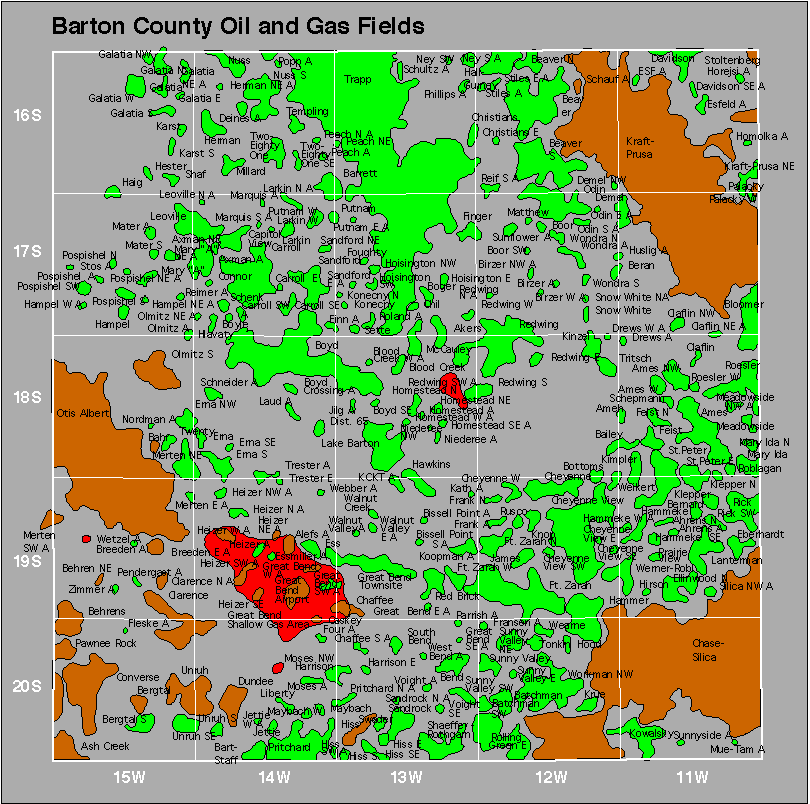
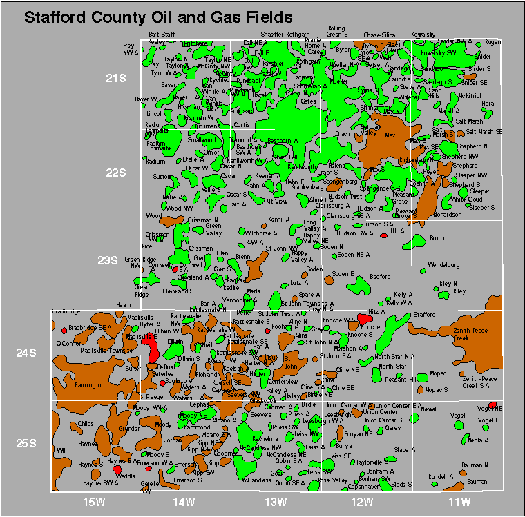
Figures 6 and 7 show the locations of all oil and gas pools in Barton and Stafford Counties.
Figure 6—Map of Barton County showing oil and gas fields. Other information is available online on the Survey's Barton County page.
![]()
Figure 7—Map of Stafford County showing oil and gas fields. Other information is available online on the Survey's Stafford County page.
![]()
Extent and value of production—During 1948 Barton County produced 21,897,415 barrels of oil and 6,127,946,000 cubic feet of natural gas; Stafford County produced 4,586,702 barrels of oil and 1,357,354,000 cubic feet of gas.
For some years Barton County has been the largest oil producer in the State. As the gravity of the oil, which determines its value, differs among the numerous pools, it is not possible to calculate exactly the value of oil produced in a given county. If the average value of oil produced in Kansas for the year, and the approximate value of natural gas at the wellhead are applied to the production in Barton and Stafford Counties, the totals are impressive, as shown in Table 4.
Table 4—Approximate value of oil and gas produced in Barton and Stafford Counties during 1948.
| County | Production | Approximate value |
County total value |
|
|---|---|---|---|---|
| Barton | Oil (bbls.) | 21,897,415 | $56,714,300 | $57,041,532 |
| Gas (M cu. ft.) |
6,127,946 | 327,232 | ||
| Stafford | Oil (bbls.) | 4,586,702 | 11,879,558 | 11,952,041 |
| Gas (M cu. ft.) |
1,357,354 | 72,483 | ||
Ceramic materials by Norman Plummer
The clays of the Dakota formation that occur in Barton County are suitable for several ceramic uses. Although these clays are exposed over a relatively small area, the amount of clay available totals several million tons. The most important clay area in Barton County is in the north half of T. 19 S., R. 13 W., and in the south half of T. 18 S., R. 13 W., between Great Bend and Hoisington.
The clays of the Dakota formation fire to colors ranging from nearly white to dark red. The clays firing to the lighter colors vary widely in other characteristics, ranging from highly plastic ball clays to extremely siliceous fire clays. Almost all these clays are refractory, having a pyrometric-cone equivalent between cone 26 and cone 30. The more plastic clays have a relatively high drying shrinkage and low firing shrinkage. The siliceous clays have relatively low shrinkages in both drying and firing and tend to be open-burning or rather porous at high temperatures. Optimum temperatures for firing the clays range from about cone 04 (1940 deg. F.) to cone 14 (2550 deg. F.). Individual clays have a long firing range which is seldom less than 200 deg. F. and in many cases is as much as 400 deg. F. The workability of the clays is good if they are neither extremely plastic nor siliceous. Suitable working properties can be obtained by blending the two types of clay.
The refractory clays are suitable for use in the manufacture of fire bricks and other refractory shapes. The white- to buff-firing clays are also excellent materials for use in the manufacture of face bricks, tiles, and pottery.
Red-firing clays also occur in the Dakota formation, and in most places in Barton County are found underlying the lighter-firing clays. The red-firing clays differ from white to buff-firing clays chiefly in that they contain a much higher percentage of iron oxide. Owing to the fluxing action of the iron oxide, these clays are less refractory and require somewhat lower temperatures for firing or "burning." Maturing temperatures for red-firing clays range from about cone 05 (1900 deg. F.) to cone 9 (2345 deg. F.). Like the lighter-firing clays, the red-firing clays have a long firing range; that is, any one sample of clay can be expected to fire to a sound product over a range of 200 deg. to 400 deg. F. This is a decided advantage in the manufacturing process in that a variety of colors can be obtained within this range of temperatures, and close controls need not be maintained on the kilns.
One ceramic plant is now using Barton County clay. The Great Bend Brick and Tile Company started production in the latter part of 1947 and is now producing about 800,000 buff face brick monthly, or the equivalent in structural tile. Clay samples numbers 1, 2, and 4, for which data are given in Table 5, were taken from the site of the clay-plant pit (SW 1/4 sec. 21, T. 18 S., R. 13 W.) for preliminary tests by the State Geological Survey. The table contains also the results of tests made by the State Geological Survey on a sample (no. 3) from sec. 33 of the same township.
Table 5—Ceramic properties of clays of the Dakota formation in Barton County, Kansas. Tests by Normal Plummer in ceramics laboratories of the State Geological Survey of Kansas.
| Sample number | ||||
|---|---|---|---|---|
| 1 | 2 | 3 | 4 | |
| Water of plasticity, percent | 19 | 17.7 | 21.8 | 14.9 |
| Linear drying shrinkage | 5.2 | 3.7 | 5.8 | 4.3 |
| Fired color at cone 3* | light buff |
cream | bright red |
purplish red |
| Linear firing shrinkage at cone 3, percent | 1.2 | 0.6 | 4.6 | 1.2 |
| Total linear shrinkage, percent | 6.4 | 4.3 | 11.7 | 5.5 |
| Absorption, percent | 10.9 | 12.9 | 4.7 | 9.1 |
| Apparent porosity, percent | 21.7 | 25 | 10.6 | 18.7 |
| Apparent specific gravity | 2.54 | 2.59 | 2.52 | 2.52 |
| Bulk specific gravity | 1.99 | 1.94 | 2.25 | 2.05 |
| Hardness, as to steel** | softer than steel |
softer than steel |
harder than steel |
softer than steel |
| Firing range, cones | 3-8 | 4-9 | 04-4 | 3-7 |
1. Composite of 22 feet of clay of the Dakota (SW sec. 21, T. 18 S., R. 13 W.)
2. Composite of 17 feet of clay of the Dakota (SW sec. 21, T. 18 S., R. 13 W.)
3. Composite of 19 feet of clay of the Dakota (NE sec. 33, T. 18 S., R. 13 W.)
4. Composite of 15 feet of clay of the Dakota (SW sec. 21, T. 18 S., R. 13 W.)
Sand and gravel
Thick deposits of sand and gravel are found in the alluvium and terrace deposits along the Arkansas and Walnut Valleys in Barton County and in the Meade formation of Stafford and southern Barton Counties. Sand and gravel of the Meade formation is exposed at the surface in places along Rattlesnake Creek, the North Fork of the Ninnescah River, and around Big Marsh; elsewhere the Meade formation is covered by a few feet to more than 50 feet of dune sand. Sand and gravel deposits of both counties have been exploited for use in road surfacing, in concrete, and in gravel-packing water wells.
Limestone
The top bed of the Greenhorn limestone has been quarried along its outcrop in the northern and western parts of Barton County and used as fence posts, bridge stone, and building stone. This bed is known as the Fencepost limestone. It is a rather hard, slightly sandy, chalky limestone about 8 inches thick. Because it is relatively free from joints, it can be split by wedges into blocks of the size and shape desired.
Salt
According to the logs of oil wells drilled in Barton and Stafford Counties, a bed of rock salt from less than 50 to nearly 200 feet thick occurs about 1,000 feet below the surface nearly everywhere in this area. Because of its great depth, the salt in Barton and Stafford Counties is only a potential resource and is of little economic value at present. Thick deposits of salt lie nearer the surface farther east in Kansas and are being exploited on a large scale.
An attempt was made to manufacture salt at Great Bend in 1888, when salt was first discovered in a boring there and the Great Bend Salt Company was formed. Two wells, each 1,400 feet deep, were drilled into the salt bed. Water was poured into the holes to dissolve the salt and pumped up as a saturated solution. The salt was then recovered by boiling and evaporation. The plant at one time employed 30 people and had a daily capacity of 400 barrels of salt (Hay, 1889, p. 200). The salt plant was abandoned after a few years.
About 20 years before the Great Bend Salt Company was formed, a small plant was built at Big Marsh in northeastern Stafford County and utilized salt water from the marsh in the manufacture of salt (Parker, 1911, p. 47). Salt from this plant was sold locally and used primarily for curing meat.
Volcanic ash
Volcanic ash is exposed in a small area in sec. 28, T. 25 S., R. 11 W., in southeastern Stafford County. Landes (1928, p. 46) analyzed a sample of ash from this deposit and stated that it was of very good textural quality. However, the deposit is too small to be of commercial importance.
The remainder of this report is concerned with ground water, one of the most important natural resources of this area.
Prev Page—Introduction || Next Page—Physiography
Kansas Geological Survey, Barton and Stafford Geohydrology
Web version Dec. 2001. Original publication date Dec. 1950.
Comments to webadmin@kgs.ku.edu
The URL for this page is http://www.kgs.ku.edu/General/Geology/Barton/03_geog.html