![]()
![]()
![]()
![]()
![]()
![]()
![]()
Kansas Geological Survey, Public Information Circular (PIC) 4
Geologic Mapping in Kansas--Part 3 of 4
The first step in constructing a geologic map is assembling the existing data--aerial photographs, measured stratigraphic sections, shallow core and borehole records, water-well information, soil surveys, and literature--to assist in field work and interpretation.
U.S. Geological Survey 7.5-minute topographic quadrangle maps are used as base maps to record the field data. These topographic maps have a scale of 1:24,000 (1 inch equals approximately 2,000 feet). They provide geologists with good detail for field work. Topographic maps use contour lines (lines of equal elevation) to show surface features, configurations, and elevations (fig. 3A).
Figure 3A--Portion of a topographic map of Douglas County.
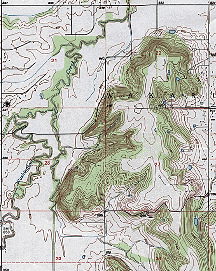
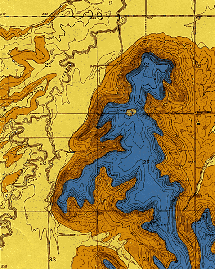
Figure 3B--Geologic map of the same area in Douglas County.
To assure consistency from one county to the next, layers (or units) of bedrock are identified according to long-established boundaries and names. Unit boundaries usually represent a change from one rock type to another--for example, shale to limestone (fig. 4). The thickness of these units can range from a few feet to tens of feet and can involve more than one type of rock. Geologists must determine what intervals are reasonably mappable over a large area before they begin mapping.
Figure 4--The geologic contact in this roadcut in Lyon County is between the shale these field geologists are standing on and the more prominent limestone above. This outcrop provides geologists with a data point for the rock unit they are mapping.
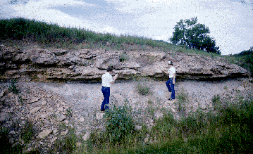
The next step is collecting data in the field. To do this, geologists drive along the roads and walk streams and gullies in the study area searching for rock outcrops that occur both naturally (streams, cliffs) and artificially (roadcuts, quarries) (fig. 4). Gravel pits and quarries are also investigated. Each bedrock exposure is examined in detail: the rock units are identified, geologic contacts (top and bottom of the mapping unit) determined, and elevations measured. The location of the outcrop is pinpointed on the base map and the elevation of the contact recorded. As information is plotted on the base map, the points are connected with a line that symbolizes the contact between rock units.
In some areas of Kansas, aerial photographs are useful for locating outcrops and for interpretation. Certain vegetation types or patterns may be related to the underlying bedrock and can be utilized in mapping. Soils maps also are useful because some soil types are characteristic of a specific bedrock unit that is near the surface.
Geologic maps are compilations of data and inference. Because most bedrock is covered by soil and vegetation, the information gleaned from "windows" into the bedrock (outcrops) are pieced together to build a map. Because outcrops may be a mile or more apart, geologists must use their training and experience to connect the data points by extrapolating and interpreting what happens between the scattered points of information. Outcrops provide the "clues"--the geologist must put all of the clues together to solve the puzzle. The geologist's job is to visualize the bedrock near the surface without the soil cover and to make a map that reflects this image.
Once field work is complete and the field maps finalized, the data are entered into a computer. The 7.5-minute quadrangles (typically between 15 and 30 per county) are each digitized (data points are scanned or manually entered into a computer) and combined to build the county map. Although digitizing the data is time-consuming, the digital data base can be used with the computerized geographic information systems (GIS) to produce digital versions of all or part of a county at a variety of scales. At the KGS, the final map product is typically published at a scale of 1:50,000 (1 inch equals about 4,166 feet). This scale is most appropriate for general-purpose use at the county level.
![]()
![]()
![]()
Kansas Geological Survey, Geology Extension
Comments to webadmin@kgs.ku.edu
Web version August 1996
http://www.kgs.ku.edu/Publications/pic4/pic4_3.html