![]()
![]()
![]()
Kansas Geological Survey, Public Information Circular (PIC) 4
Robert S. Sawin,
Geology Extension, Kansas Geological Survey
Geology is a part of our everyday lives, usually in ways we don't think about. Ignoring geology, however, can be expensive. In Kansas, economic losses sustained from geologically related factors cost businesses and individuals millions of dollars each year. Highways sink, buckle, or are displaced; houses slide down the hillside; buildings crack or are infiltrated by ground water. Understanding the near-surface geology and incorporating geologic evaluations into the planning process can prevent some of these problems.
Geologic maps are the principal source of information about the near-surface geology and are essential for guiding public policy, evaluating earth resources, and making economic decisions.
The Kansas Geological Survey (KGS) is currently undertaking a program of geologic mapping in Kansas that is aimed at making basic geologic information available to the public. This circular explains what geologic maps are, how they are made, what they are used for, and why they are valuable.
Geologic maps are an important source of natural-resource information. Geologic maps depict the bedrock (solid rock directly beneath the soil) at or near the earth's surface as if the soils and vegetation had been removed. Technically, these maps should be called bedrock geologic maps.
Geologic maps graphically show the distribution, rock type, age, and horizontal distribution of bedrock near the earth's surface (fig. 1). Examples of bedrock that occur in Kansas are limestone, sandstone, and shale. Geologic maps also show the related geologic structures (faults, fractures, and folds) that would be exposed if the soils were stripped away. Thick surficial materials that have been transported in by wind, water, or ice (e.g., alluvium, loess, sand dunes, glacial drift) also are mapped. In stream valleys, thick deposits of unconsolidated sand, gravel, clay, and silt have been deposited in more recent times; these deposits can be tens of feet thick. This material, termed alluvium, is younger in terms of geologic time than the underlying bedrock. In some areas, the bedrock is covered by thick deposits of windblown sand (sand dunes) or silt. Windblown silt deposits are called loess. Glacial drift is material transported by glaciers and deposited directly on the land.
Figure 1--Portion of geologic map, Montgomery County.
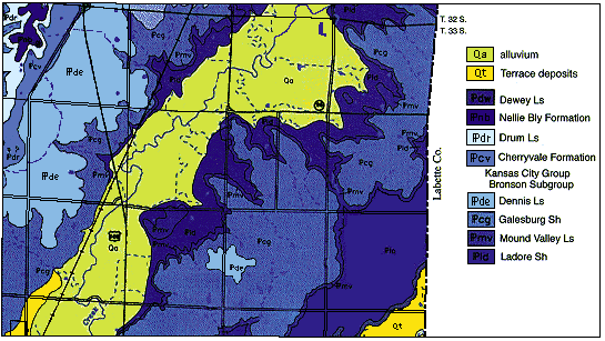
A geologic map shows the distribution of rock units and other geologically related information within a specific geographic area. Each rock unit is identified and named based on distinctive characteristics that can be mapped over large distances. Geologic maps provide a way of presenting the three-dimensional shape of the bedrock geology on a flat piece of paper using lines, symbols, and colors.
You may also want to visit the KGS Digital Geologic Mapping Page, containing information on maps available and sample county maps.
Kansas Geological Survey, Geology Extension
Comments to webadmin@kgs.ku.edu
Web version August 1996
http://www.kgs.ku.edu/Publications/pic4/pic4_1.html