![]()
![]()
![]()
![]()
![]()
![]()
![]()
Kansas Geological Survey, Public Information Circular (PIC) 4
Geologic Mapping in Kansas--Part 2 of 4
Geologic maps are usually the first source of information--the starting point--for any geologically related investigation. They are useful in construction and engineering projects, city and county planning, and in a variety of environmental activities. Large projects (dams, roads, bridges, buildings) require detailed geological analysis because of monetary, health, and safety concerns. Smaller projects, such as surface-water impoundments, houses, and water wells, also benefit from an understanding of the surface bedrock. For example, if a farm pond is located in a porous bedrock unit (such as sandstone), that unit may function as a drain and the pond will not hold water. If placed in a nonporous unit, such as shale, which contains clay that forms a tight seal, the pond should not leak. This basic information about the local geology can be ascertained from a geologic map. Other examples of how geologic maps can be used include
Geologic maps can be used to evaluate and predict the consequences of natural and human-induced activities on the environment. The use of geologic-map information during a project's planning and design stage produces long-term benefits and reduces problems that may develop after the project is completed.
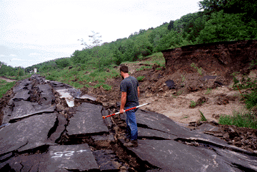
Figure 2--McDowell Creek Road just south of Manhattan, Kansas. Damage caused by a landslide to over one-quarter mile of the road after heavy rains during the spring of 1995. The roadway was displaced about 20 feet vertically and 40 feet horizontally by the slide.
![]()
![]()
![]()
Kansas Geological Survey, Geology Extension
Comments to webadmin@kgs.ku.edu
Web version August 1996
http://www.kgs.ku.edu/Publications/pic4/pic4_2.html