![]()
Prev Page--Chapter VIII || Next Page--Chapter X
Chapter IX--Resume of the Stratigraphy and Correlations of the Carboniferous Formations
by Erasmus Haworth
| Outlines of Stratigraphy. | |
| A.-The Mississippian. | |
| B.-The Coal Measures: | |
| The Cherokee Shales. | |
| The Oswego Limestone. | |
| The Pawnee Limestone. | |
| The Pleasanton Shales. | |
| The Erie Limestone. | |
| The Thayer Shales. | |
| The Iola Limestone. | |
| The Carlyle Limestone. | |
| The Lane Shales. | |
| The Garnett Limestone. | |
| The Lawrence Shales. | |
| The Oread Limestone. | |
| The Osage City and Burlingame Shales. | |
| The Wabaunsee Formation. | |
| The Cottonwood Falls Limestone. | |
| The Cottonwood Shales. | |
| Characteristics of the Coal Measure Limestones. | |
| Characteristics of the Coal Measure Sandstones. | |
| Characteristics of the Coal Measure Shales. | |
| Coal Measure Shales Principally Submarine in Origin. | |
| Inclination of the Coal Measure Strata. | |
| Faults in the Coal Measures. | |
| Ratio of the Coal Measure Limestones to Shales and Sandstone. | |
| Thickness of the Coal Measures. | |
| Division of the Kansas Coal Measures. | |
| C.-The Permian | |
| The Lower Flint Beds. | |
| The Upper Flint Beds of Hay or Florence Flint of Prosser. | |
| The Fort Riley or Florence Limestone. | |
| Ratio of the Permian Limestone to Shales. | |
| Inclination of the Strata in the Permian. | |
| Faults in the Permian. | |
| General Resume. | |
| Correlations with the Work of other Geologists. | |
The eight preceding chapters have been chiefly devoted to detailed descriptions of the stratigraphy of as many different sections reaching wholly or partially across the Carboniferous formations of the state. This chapter will be devoted to a general review of the stratigraphy of the whole area, an attempt to correlate the different systems, and point out any general principles which may have been omitted or only partially discussed in the preceding chapters. It may at times be necessary to repeat statements already made in order to place the matter. properly before the reader.
One of the first conceptions to be gained regarding the stratigraphy of the Carboniferous is that in general nearly all the formations above the Mississippian both dip and thicken to the west, particularly in the Coal Measures, and that occasionally a wedge shaped formation: which may be quite heavy under ground at one place fails to reach the surface to the east on account of its thinning out in that direction until it entirely disappears. The second point of general importance is that while the Carboniferous consists of limestones, sandstones, and shales, the limestones are by far the most regular and persistent laterally, and therefore are of the most importance stratigraphically, although they never nearly equal the others in thickness. There are great shale beds, it is true, which are remarkably persistent and tolerably regular. If we look upon them as the principal formations with occasionally included sandstones, into which they may grade and again change back into shales, we can use them very well. In this way we would consider but two formations, the limestones and the shales. Our drawings for plates I to VIII inclusive were made in this way, the limestones being represented by the ordinary conventional masonry, while the shale beds with their included sandstone are left blank. It is believed not only that this is the best mode of representation to impart to the casual observer a fair idea of the stratigraphy of the Carboniferous, but that the student who, with report in hand, may pass over the ground to correct or verify the conclusions here reached will also find it to his advantage actually to think of them in this way.
Outlines of Stratigraphy
Beginning at the base of the Carboniferous we will now mention in ascending order each formation of any considerable thickness up to the Dakota Cretaceous, and add such remarks of a general character as may be deemed advisable in order to give a clear and connected description of the location and extent of each of them. The detailed descriptions already given for different localities will be referred to quite often, and the different drawings will be freely used. Plate XXII is a generalized section of the Carboniferous. The total thickness here given above the Mississippian is 800 feet for the Lower Coal Measures, 1,950 feet for the Upper Coal Measures, and 795 feet for the Permian, the thickness of the Mississippian being indeterminable within the state excepting by drilling. The maximum thickness of the different formations was never used in making these estimates; neither was the minimum. Probably at no one place would the drill prove the distance to the Mississippian to quite equal these figures, but there certainly could not be much of a decrease in the thickest portions.
A--The Mississippian
The Mississippian area within the state is so small one must necessarily go beyond the limits of Kansas to study it. Yet the unusually rich deposits of lead and zinc ores within it have given to the thirty square miles in the southeastern part of the state a reputation for productiveness unequalled perhaps by any like area in the world. Earlier geologists have placed these rocks in the Keokuk group, which constitutes one member of the "Augusta" of Keyes [Iowa Geol. Surv. vol. 1, p. 59; Des Moines, 1892]. They are composed of limestones and cherts irregularly interbedded, with shales appearing in some localities. The chert constitutes nearly all of the rocks in certain places, particularly in the mining districts where it carries the greater portion of both the lead and zinc ores. In other places the chert becomes less permanent and the limestone increases in relative proportion. Along the north bank of Short creek at Galena the limestone is tolerably common in the bluffs and hillsides, but to the south it seems to have been eroded away or replaced by chert. Both the limestones and cherts are well filled with invertebrate fossils.
The upper surface of the Mississippian was badly eroded before Coal Measure time, at least near the eastern borders of the Coal Measures, as expressed in chapter I. Westward and northward the formation extends as far as deep drilling has been done, so that we have good evidence that it underlies all of eastern Kansas. Its surface inclines rapidly to the west and northwest, but it cannot be determined whether or not the surface erosion extends very far in this direction, as the information given by the drill would have no positive bearing on the subject. By recalling the depths at which the Mississippian was reached along the lines of the various sections already described, we can locate this surface quite well. It seems to decline westward more rapidly than in any other direction, as will be seen from the following summaries. At Galena it occupies the hilltops a thousand feet above sea level with the lowest valleys about 850 feet. At Oswego it has been reached by at least two wells 400 feet above sea level, which is a decline of fully 475 feet from the valleys at Galena, twenty-five miles away, or of about 600 feet from the hilltops, or something over 20 feet to the mile. Wells at Stover and Mound Valley did not reach the Mississippian, but at Cherryvale fifty miles away it was reached 1,008 feet below the surface, which places it 180 feet below sea level. As this well was made with a diamond drill and an excellent core preserved there can be no reasonable doubt about the correctness of these figures. [This core has recently been lodged in the museum of the University of Kansas in a well preserved form, where it can be examined by any geologist wishing to do so.] This gives a westward inclination of more than 20 feet to the mile. At present we have no definite data regarding the depth from the surface to the Mississippian west of Cherryvale. A well three miles west of Independence reached 1,100 feet without striking it, one at Niotaze 1,158 feet, and one at Wichita 1,950 feet, so we can only say it lies below these several depths at the respective places. To the northwest it was reached at Neodesha 135 feet below sea level, at Fredonia 310 feet, at Fall River 430 feet below sea level, giving about a 17-foot decline to the northwest. At Osage Mission, thirty-nine miles from Galena, a well 700 feet deep failed to reach it. At Chanute, fifty-eight miles away, it was reached 36 feet below sea level, and at a few other points in that vicinity at similar depths. The decline from Galena to Chanute straight northwest is consequently nearly 17 feet to the mile, considerably less than in a more westerly direction. Northward along the east line of the state it was reached at Girard 493 feet above sea level, at Fort Scott 385 feet above sea level, at Pleasanton 206 feet above sea level, at Paola 182 feet below sea level, at Kansas City at sea level, and at Leavenworth over 300 feet below sea level. [Paola: A little doubt has been expressed regarding the correctness of this well record. The record used is preserved in the city public library at Paola. The criticism is to the effect that the Mississippian comes about 200 feet nearer the surface, which would correspond better with its depth at Pleasanton and Kansas City.] A well at Topeka 1,638 feet deep, or about 775 feet below sea level, failed to reach it, and one at McFarland 2,006 feet deep, or about 1,000 feet below sea level, failed to reach it. The inclination from Galena to Kansas City is, therefore, only about 6.5 feet to the mile. But as the southeastern boundary of the Coal Measures is a line running northeast and southwest the latter point should be reckoned, not from Galena, but from the nearest point of surface exposure of the Mississippian. According to the geological map of Missouri published by Winslow [Preliminary Report on Coal, 1891, and succeeding volumes] the Mississippian occupies the surface at Sweet Springs and a few miles to the west, bringing it to within fifty miles or less of Kansas City. Reckoning in this way we have a decline of the floor from near Sweet Springs to Kansas City of about 15 feet to the mile, to Topeka at least 14 feet, how much more we cannot say, and to McFarland of 13 feet to the mile, with probably considerably more, which is less than the decline along the southern line of the state. From the above data we can calculate the decline in any direction. From Kansas City to the southwest we find almost a level in the floor towards Chanute and Cherryvale, but a decline of about 3 feet to the mile towards Fall river.
From these. and other similar data we may conclude that the Mississippian formation underlies all, or nearly all, of the Coal Measures in Kansas, and that its upper surface is strongly inclined westward, equalling 20 feet to the mile along the south line of the state, and at least 10 feet to the mile for.the whole distance to Wichita, and probably more, while to the north as far as Kansas City the inclination averages only about 6.5 feet to the mile, with an intermediate value in intermediate directions. According to Winslow. [Preliminary Report on Coal, 1891, p. 24] in a direction northwest, from Sedalia the Mississippian floor declines about 1,600 feet in 150 miles, or a little more than 10 feet to the mile, but he gives no data regarding the inclination in other directions.
B--The Coal Measures
The Cherokee Shales
[Haworth and Kirk: Kansas Univ. Quar., vol. 2, p. 105, Jan. 1894.]
First above the Mississippian, or at the base of the Coal Measures, lie the Cherokee shales with an average thickness of about 450 feet, which, with their included sandstones, constitute the most remarkable formation in some respects in the whole Coal Measures. They have great lateral extent, as is shown from many drillings; how great is not determined., At Cherryvale they are nearly 425 feet thick; at Neodesha fully 425 feet; at Chanute 410 feet, and the deep wells at Humboldt and Iola did not pass entirely through them; at La Harpe they are 345 feet; at Fredonia they seem to be only about 350 feet, but they thicken again to 375 feet at Fall River. To the north they reach to Leavenworth, with the following thicknesses at the various places, as shown on plate II: Girard 446 feet, Fort Scott 410 feet, Pleasanton 440, Paola 750, Kansas City 420, Topeka at least 700, and Leavenworth 540. [Paola: A little doubt has been expressed regarding the correctness of this well record. The record used is preserved in the city public library at Paola. The criticism is to the effect that the Mississippian comes about 200 feet nearer the surface, which would correspond better with its depth at Pleasanton and Kansas City.] With such thicknesses as these at the different places named, we may well conclude they reach much farther to the west. There are also many reasons for believing that the same shale beds reach entirely across the state of Missouri and into Iowa. Broadhead [Missouri Geol. Surv. Rep., 1872, part 2, p. 88] mentions a few deep borings, particularly one in Hay county, which shows them to be about 400 feet thick at that place, and in his general section of the Missouri Coal Measures he gives from 350 to 450 feet of shales and sandstones at the base. Other wells recently drilled in northern Missouri bear similar evidence. From the accounts of the Iowa Coal Measures given in the different reports of that state and from the writer's knowledge of portions of the state, it is reasonably certain that nearly the whole of the Iowa Coal Measures have a heavy shale bed at their base, the Des Moines formation of Keyes [Iowa Geol. Surv. Rep., vol. 1, page 126; Des Moines, 1894], which connects directly with the similar one in Missouri and that in turn with the Cherokee shales in Kansas. Southward into the Indian Territory the same shale bed extends for many miles, and probably it connects with the heavy shale beds at the base of the Coal Measures in Arkansas and Texas, making one continuous formation many hundred miles in extent. This correlation has not been definitely determined, but there can be little doubt of its correctness.
In character the Cherokee shales vary greatly both vertically and laterally. Portions of them are bituminous, portions are argillaceous, and arenaceous. In color they are as variable as in composition. Some are almost a jet black, others a light gray, and others representing the various colors usually characteristic of Coal Measure shales. They are exceedingly rich in coal, producing at the present time more than two-thirds of the whole amount mined within the state, supporting all the mines in the vicinity of Weir City, Pittsburg, Cherokee, and to the northeast to Arcadia, as well as those about Fort Scott and Leavenworth. The well records to the west show frequent veins of coal. At Cherryvale a 27-inch vein was passed about 15 feet above the base, and several lesser ones above. At Topeka 11 veins were passed, while every well record examined shows three or more.
Here and there throughout the Cherokee shales greater or lesser beds of limestone occur, usually from 6 to 15 inches in thickness, of very limited lateral extent, but occasionally 4 or more feet, although none of them seem to have sufficient lateral extent to be of importance stratigraphically. They generally contain many invertebrate fossils from the list of which the following are taken [Copied from catalogue of Kansas Coal Measure fossils prepared by Rev. John Bennett, Fort Scott, and constituting chapter XV of this volume]: Fusulina cylindrica in extreme upper portion, Ptilodyctia triangulata, Rhombopora lepidodendroides, Athyris lamellosa, Athyris subtilita (found in almost every limestone in the Coal Measures), Chonetes mesoloba, Discina nitida, Productus longispinus, Productus costatus, Spirifera camerata, Spirifera plano-convexus, Spirifera lineata, Nucula ventricosa, Schizodus —— (very large), Bellerophon carbonaria, Macrocheilus primigenius, Nautilus plano-voluis (?).
The Oswego Limestone
[Haworth and Kirk: Kansas Univ. Quar., vol. 2, p. 105, Jan. 1894.]
Above the Cherokee shales are two limestone systems separated by from 4 to 7 feet of an unusually black shale. Each is from 5 to 15 feet thick, and they are wonderfully persistent laterally for limestone so thin. The Cherryvale, Neodesha, Fredonia and Fall River well records show they extend that far west. They outcrop on the surface in a sinuous line passing from the south side of the state to the northeast by way of Oswego, Girard, and Fort Scott, near which point they cross into Missouri, and they are found at or near the surface over the zone from 5 to 15 miles wide lying northwestward from their line of outcropping. Some of the different well records to the north show them, arid quite likely they were passed in the borings at Kansas City and Topeka, although one cannot well decide regarding so thin limestones without more intervening wells. The lower limestone is the "cement rock" quarried and manufactured so extensively into hydraulic cement at Fort Scott. These two limestone systems are so close together that they may be classed as one; yet the black shale lying between them is widespread and so bituminous that it must have been formed in very shallow water and dose to it dry land area.
Both of the limestones and the associated black shales are well filled with fossils, from the list of which the following are representatives. The corals and crinoids are particularly abundant and large: Fusulina ventricosa (?), Campophyllum torquium, Syringopora multatenuata, Zeacrinus mucrospinus, Chaetetes milleporaceus (very plentiful), Ptilodictia triangulata (rare), Rhombopora lepidodendroides, Chonetes mesoloba, Productus costatus, Productus nebrascencis, Productus punctatus, Retzia mormoni, Rhynchonella uta, Spirifera lineata, Allorisma subcuniata, Aviculopecten —— (first seen in upper limestone), Nuculana bellistriata, Orthis carbonaria, Bellerophon montfortanus, Naticopsis ventricosa, Pleurotomaria sphaerulata; Gonetites ——, Nautilus ferratus, Orthocerus rushensis, Phillipsia major.
Above the Oswego limestone lies a bed of shales of variable thickness. In places it is over 40 feet, but the borings at Mound Valley and Cherryvale and all those made north of Thayer as well as those north of Fort Scott show that it almost entirely disappears in those directions. North of Fort Scott it carries considerable coal which supports local mines.
The Pawnee Limestone
[Swallow: Geology of Kansas, 1866, p. 21.]
Above the shale bed last mentioned a limestone occurs in the southern part of the state which also thins towards the north. It was recognized by Swallow, and has been mentioned by almost every geologist writing on that locality since. It is particularly well developed in the vicinity of Fort Scott and to the southwest for a number of miles, as has already been given by Bennett in chapter IV. It may be noted as having the least lateral extent in proportion to its maximum thickness of any limestone system known in the whole Carboniferous area. Yet possibly after all, could we have authentic records of wells sufficiently close together to the west and north, we might be able to prove its existence for a greater distance than is now known. As the shales between it and the Oswego limestones thin out to the west and north the Pawnee limestone and the Oswego limestone are brought close together, so that in a way they may be looked upon as constituting one great limestone system. Various well records to the northwest show this. We have, therefore, above the Cherokee shales and below the next great shale bed a series of limestones the existence of which is proved by almost every well record studied in the state, so that one or all they are of very great lateral extent.
The Oswego limestone and the Pawnee limestone are rarely if ever horizontal, and the dip is quite irregular. As pointed out in chapter II, they abound in small and low anticlinals and synclinals. These irregularities are as great as almost any others noticed in the whole area.
The Pawnee limestone affords the following fossils in considerable abundance, with many others not given: Cyanthaxonia distorta, Lophophyllum proliferum, Fistulapora nodulifera, Productus longispinus, Spirifera lineata, Spiriferina kentuckiensis, Pleurotomaria sphaerulata.
The Pleasanton Shales
[Haworth: Kansas Univ. Quar., vol. 3, p. 274; Lawrence, April, 1895.]
Above the Pawnee limestone are the Pleasanton shales, which in places approach 250 feet in thickness, Their greatest thickness is towards the southwest. To the north from Pleasanton they rapidly grow thinner, so that at Fontana and Paola they are relatively unimportant, but they thicken again until at Kansas City they are 180 feet thick. Southwestward from Pleasanton they maintain their thickness quite well and constitute a considerable portion of the high divide between the Neosho and Verdigris rivers. As is so common with all the Carboniferous shales, they often grade into sandstone, which in turn passes back to shales, so that wherever they are examined one is liable to find considerable arenaceous properties. At their summit at Boicourt a heavy bed of sandstone from 10 to 12 feet thick has furnished large quantities of stone for bridge building and other purposes. In places they also carry extensive beds of flagging stone, for detailed information of which the reader is referred to the preceding chapters, particularly chapter IV.
The Pleasanton shales also carry large quantities of coal. In the vicinity of Pleasanton and Boicourt coal mining has been conducted for nearly 40 years, earlier by the strip pit method, but more recently by shafting. At least two distinct veins of coal occur nearly a hundred feet apart, and possibly more, so that they are quite noted in this respect. Here and there also considerable calcareous material is met with. In the section along the Marmaton one limestone mass aggregating 8 feet in thickness was described by Bennett, yet its lateral extent was not sufficient to warrant a separation of the shale bed on account of it. Other lesser limestone masses have been found, all of which carried an abundance of fossils, of which the following may be named: Cyanthaxonia distorta; Athyris trinuclia, very rare; Chonetes mesoloba, last seen here; Discina nitida, becoming rare; Rhynchonella uta.
According to Mr. Bennett there is the greatest change in the fauna at the top of the Pleasanton shales noted anywhere in the Coal Measures. For this and other reasons the top of this shale bed has been chosen for the uppermost limit of the Lower Coal Measures.
The Erie Limestone
[Haworth and Kirk: Kansas Univ. Quar., vol. 2, p. 188; Lawrence, Jan. 1894.]
At the close of the formation of the Pleasanton shales a limestone forming period was ushered in. Limestone almost to the extent of 100 feet in thickness was formed in some parts of the state, not in one continuous mass; however, but separated by thin and relatively unimportant shale beds. As shown on the surface this process was carried to the highest degree of perfection in the country to the west of Fort Scott, and is well illustrated in plate IV. Here we have three distinct systems one above the other which are so close together that they properly should be. regarded as one great system. To the south, however, they soon separate considerably, so that the intervening shale beds assume considerable thickness. The individual limestone systems also decrease somewhat in thickness, and therefore have been a less important factor in producing the topography of the country. The lower one seems to pass a little above Osage Mission, from there to the east of Parsons a mile or two, and by the way of Altamont to beyond the south line of the state, leaving the great bed of Pleasanton shales between Altamont and Oswego. Throughout this distance the outcropping of the limestone is not very strongly marked by surface features. The middle of the three limestones likewise passes to the southwest with its eastern margin gradually growing farther from the Altamont limestone, so that it passes near Mound Valley southward to beyond the state line. In this case, however, there is a bold escarpment which marks its eastern limit from the state line northward fifteen or twenty miles, beyond which it gradually merges into a similar escarpment produced by the Erie limestone systems combined. At Mound Valley the vertical distance between the middle and the lower of the three limestones is approximately 125 feet, as has been explained by Adams in chapter I. The uppermost of the three limestones follows a course similar to that of the other two, excepting its eastern boundaries bear to the west more decidedly still and pass near Erie, Galesburg, Cherryvale, and Liberty. Throughout portions of this distance a strongly marked topography results from the combination of conditions produced by the limestone and the underlying shale bed. For many miles there is a row of bluffs or isolated mounds similar to those in Mound Valley, only more pronounced.
From the vicinity of Uniontown northward the Erie limestone systems remain tolerably close together, passing Mound City, Pleasanton, Boicourt, La Cygne, and Fontana, and reaching to the northeast across the state line. Throughout the whole distance the topographic features are similar to those in the vicinity of Mound Valley and Cherryvale, but here they are produced by the Erie limestones serving as a protection above the Pleasanton shales which have their maximum thickness in this vicinity. These limestones as a whole are very interesting in many ways. Their separation to the southward producing the radiated structure is different from that usually found in the state, the uppermost layer thickening so rapidly to the westward from Cherryvale, reaching a thickness of 40 feet at Independence, and the remarkably large masses of flint which they carry, particularly in the vicinity of Uniontown, are some of their prominent characteristics. Northward they extend to the bluffs along the Missouri river. Broadhead [Report Missouri Geol. Surv. 1872, part 2, p. 77] has named the lowermost member the Bethany Falls limestone, number 78 of his section. According to his report it reaches from the north line of Missouri to Kansas City. In a section made by Professor Tilton [Iowa Geol. Surv. Rep., vol. 3, p. 137; Des Moines, 1895.] a heavy mass of limestone is met with between Bevington and Winterset which has been traced southward to the Missouri line,where the lower portions of it may be correlated with the Bethany Falls limestone. [Note: Keyes, Am. Jour. Sci., vol. 50, p. 243; New Haven, 1895. Doctor Keyes suggests that inasmuch as this correlation has been perfected, the term Bethany Falls limestone should be applied to the whole group. It is quite evident that Broadhead did not intend his Dame Bethany Falls to be used in so extensive a sense, and as the term Erie limestone was proposed nearly two years before the suggestion made by Doctor Keyes, priority would not allow the use of the term as he suggests.] To the northwest from the outcropping of the Erie system every well record examined shows large quantities of limestone to exist. It seems that they represent a period noted all over the Carboniferous of Kansas for great limestone productions. The shale partitions between them vary in thickness, sometimes aggregating several hundred feet, as from Altamont to Cherryvale, at other times dwindling to so thin beds that in some of the well records, particularly the one from Fall River, the shales are scarcely represented, although they were actually present. In other places the shales first above the Erie limestone, the Lane shales, grow thin so that the Erie limestones seem almost to coalesce with the great Iola limestone beds, which intensifies the limestone forming action at this period. Every well record studied for the whole state shows that aggregated or separated they occur in increasing thickness westward, increasing principally at the expense of the intervening shale beds.
The Erie limestones abound in fossils, from the list of which the following species are selected as representatives: Fusulina cylindrica, Axophyllum rudis, Campophyllum torquium, Archiocidaris mucronatus, Archiocidaris triserrata, Erisocrinus typus, Eupachycrinus tuberculatus, Scaphocrinus hemisphericus, Zeacrinus acanthophorus, Serpula incita, Spirorbis carbonaria, Fennestella ——, Polypora submarginata, Synocladia biserialis, Chonetes granulifera, Chonetes smithi, Chonetes millepunctatus, Orthis precosi, Orthis robusta, Orbiculoida ——, Productus americana, Productus pertenuis, Productus symmetricus, Syntrialasma hemiplicata, Terebratula bovidens, Allorisma granosa, Allorisma reflexa, Allorisma subcuneata, Aviculopecten carboniferus, Aviculopecten interliniatus, Aviculopecten providencensis, Aviculopecten americana, Chaenomya leavenworthensis, Conocardium obliquan (very rare), Edmondia aspinwallensis, Edmondia ovata, Edmondia reflexa, Macrodon carbonarius, Monopteria gibbossa, Myalina subquadrata, Myalina swallowi, Nucula parva, Pinna paracuta, Pleurophorus oblongus, Schizodus wheeleri, Solenopsis solenoides, Bellerophon crassus, Loxonema rugosa, Naticopsis gigantia, Platyceras nebrascenses, Pleurotomeria turbiniformia, Peupa vitusta, Conularia crestula, Goneatites lyoni, Nautilus occidentalis, Nautilus ponderosus, etc.
The Thayer Shales
[These shales were called the Chanute shales, Haworth and Kirk: Kansas Univ. Quar., vol. 2, p. 109, Lawrence, January, 1894; but were changed to Thayer shales, Kansas Univ. Quar., vol. 3, p. 276, Lawrence, April, 1895.]
Above the Erie limestone in the southern part of the state heavy shale beds occur, which in Neosho, Wilson and Montgomery counties reach a maximum thickness of over 200 feet, but which grow thinner northward until they became less than 30 feet in thickness. They are prominent from Chanute to the southwest, and constitute the main masses of the bluffs along the Verdigris and Fall rivers from Benedict and Fredonia southward to beyond Independence. The famous Table Mound north of Independence is composed almost entirely of them, on the western side of which a section of 200 feet or more is shown. They have been passed through by every prospecting well in this part of the state west of their outcropping, so that we know they extend many miles westward under the superimposed strata. They frequently grade into sandstone, furnishing many workable quarries of that rock in various places, particularly in the vicinity of Thayer, Neodesha, and Independence. Ripple marks and other indications of shore deposits are frequently found in them and the arenaceous shales associated with them. These shales also carry two or more seams of coal, which are mined locally to a considerable extent in the vicinity of Thayer, from which the surrounding country is largely supplied.
The Iola Limestone
[Haworth and Kirk: Kansas Univ. Quar., vol. 2, p. 109; Lawrence, January, 1884.]
At the close of the period in which the Thayer shales were produced a great limestone-forming period was ushered in, producing the most extensive limestone system to be found anywhere within the Carboniferous of the state--the Iola limestone. To the southwest, in the vicinity of Elk City, it is reported from a well to be 100 feet thick. Northeast of this it diminishes in thickness until, at Iola, it is only 40 feet. Still farther northeast it diminishes more, so that in places it is not more than 20 feet thick; but in the vicinity of Olathe it thickens locally to at least 50 feet. Northward from here it reaches to the bluffs along the Kansas and Missouri rivers, is the most prominent heavy limestone at the top of the bluff in Kansas City, and extends far to the north and east into the state of Missouri, passing below the railroad bed along the Missouri river at Connor. Its southeastern outcropping marks the crest of a row of bluffs from the south line of the state to the vicinity of Mound City, at which place the Thayer shales decrease in thickness to such an extent that the topographic features due to the Iola limestone coincide with similar ones produced by the Erie limestone. The distance to which this limestone extends beneath the surface can only be conjectured. The wells at Topeka and Fall River, the farthest west of any in the Carboniferous, show that it occurs in undiminished thickness, while everyone in the intervening area shows the same fact.
In places the Iola limestone is very fossiliferous, producing the following species with many others: Michelinia eugeneae, Athyris subtilita, Lingula scotia, Productus longispinus, Produotus pertenuis, Spirifer camerata, Spirifer lineatus, Aviculopecten carboniferus, Pinna subspatulata, Nautilus occidentalis, Nautilus missouriensis.
The Carlyle Limestone
[Haworth and Kirk: Kansas Univ. Quar., vol. 2, p. 110; Lawrence, January, 1894.]
Above the Iola limestone is a thin bed of shales with no marked characteristics and of but little stratigraphic importance. They have been described in both chapter IV and chapter VII. Above these we encounter the Carlyle limestone, which also has been mentioned in chapters III and VII. The northeastern limitations of this limestone have not been fully determined. At some places it seems to occur, while at others it is scarcely noticeable. From Iola northward to Kansas City, and thence up the Kansas river to Lawrence, a thin limestone system is found above the Iola limestone which corresponds in position and thickness very well with the Carlyle limestone, and quite likely it is the same, although exact correlations have not been made.
The Lane Shales
Above the Carlyle limestone the Lane shales are next reached. These have been reviewed in chapters II, III, V, and VII, in the latter of which their extent and great stratigraphic importance has been particularly dwelt upon, so that nothing need be added here.
The Garnett Limestone
[Haworth and Kirk: Kansas Univ. Quar., vol. 2, p. 110; Lawrence, January, 1894.]
Immediately above the Lane shales are two limestones separated by from 10 to 15 feet of shales. They appear in the bluffs at Argentine and from the upper limestone westward to Eudora, and have been passed by borings at Lawrence and Topeka, They cover the surface over a wide area along the Pottawatomie and Neosho rivers and northward to Eudora and Argentine, and extend southwest across the Neosho river and probably to beyond the limits of Kansas. North of the Kansas river they extend to Leavenworth, where they dip almost to the water's edge, and from here across the river to Plattsburg, Mo., and beyond.
In places they thicken greatly. At the Lane "marble" quarries the upper one has reached the thickness of 30 or 40 feet, as it has also done about three miles east of Greeley. The most common invertebrate fossils found in them are the following: Campophyllum (?), Fenestella (?), Synocladia biserialis, Derbya (?), Productus americanus, Productus semireticulatus, Syntrialasma hemiplicata (very abundant in places), Myalina kansensis, Myalina recurvirostris, Euomphalus subrugosus, Naticopsis altonensis, Pleurotomaria tabulata, Nautilus occidentalis, and about 40 other species.
The Lawrence Shales
[Haworth: Kansas Univ. Quar. vol. 2, p. 122; Lawrence, January, 1894.]
These shales in the vicinity of Lawrence are near 300 feet thick, if we let the name cover all lying between the Garnett limestone and the Oread limestone above. Occasionally a thin limestone occurs within them, one of which sometimes reaches 6 or more feet in thickness, but none of which have sufficient lateral extent to be of much consequence in stratigraphy. Southward from Lawrence they become thinner, so that along the Neosho river and to the south they gradually lose their great importance. Northward they maintain their thickness much better. They vary greatly in character in different places. They carry a prominent coal seam, which is mined extensively in Franklin county and to a lesser degree elsewhere, especially in Douglas county, and recently near Atchison. They carry a great deal of sandstone, but none of which is of a proper quality to be of much value economically. They are also particularly interesting on account of the large amount of arenaceous shales they have, almost all of which are filled with ripple marks and other indications of shore deposits. In fact, from top to bottom, they have such markings the most abundantly of any shales thus far passed. They also furnish excellently well preserved specimens of fossil coal plants.
The great thickness of the Lawrence shales produces marked physiographic effects. A great escarpment may be traced from Leavenworth far to the southwest of Ottawa, the bluffs of which are composed entirely of these shales, while an exceedingly rugged form is preserved by the protection of the overlying limestones.
The Oread Limestone
[Haworth: Kansas Univ. Quar., vol. 2, p. 123; Lawrence, January, 1894.]
Above the Lawrence shales are found two limestones averaging about 15 feet thick separated by about 20 feet of shale. They outcrop along the tops of the bluffs reaching from Atchison and Leavenworth to considerably south of Garnett, and take their name from Mount Oread at Lawrence. Westward they extend as far as any drill record has been obtainable. The upper one constitutes the main limestone in the bluffs at Lecompton and Atchison. Each is well filled with fossils, but particularly the upper one, from which 49 species were gathered in a few hours time at Lecompton. The following is a partial list: Fusulina cylindrica, Cyathaxonia distorta, Archiocidaris (?), Scaphiocrinus (?), Chonetes granulifera, Derbya bennetti, Derbya broadheadi, Meekella striata-costata, Orthis robusta, Productus semireticulatus, Retzia mormoni (large variety), Syntrialasma hemiplicata, Allorisma regularis, Astartella (?), Avicula longa, Edmondia nebrascensis, Entolium avicula, Monoptera marian, Pleurotomaria bonharborensis, Nautilus sangamonensis, Palaeocaris tipus.
Above the Oread limestone is a bed of shale a little more than 60 feet thick, after which come the three Lecompton limestones exposed on the hilltop south of Lecompton. They are only a few feet thick and are separated by thin shale beds. Above them is another shale bed about 75 feet thick, the two thin limestones exposed at Tecumseh, another shale bed 50 or 60 feet thick, and then the three limestone systems which appear near Topeka. These are of little interest except from their position. Above them lies another shale bed 50 feet thick, at the top of which lies the Topeka coal, a seam about 11 inches thick which has been mined at different places. The coal is immediately overlaid by two thin limestone beds separated by less than 3 feet of shale.
[Note: Since this volume started through the press, Mr. J. W. Beede, of Topeka, a young man fully capable of doing the work, has run a section to the southwest from Topeka, connecting the Topeka coal with the Carbondale-Burlingame coal, and has shown that the Topeka coal, and not that at Dover 100 feet above, should be correlated with the Carbondale-Burlingame-Osage City coal. The Dover coal is represented by a thin seam in the bluffs at Burlingame. This volume is therefore in error in a number of places where the Dover coal is correlated with the Osage City coal.—E. H.
Osage City and Burlingame Shales
[Kansas Univ. Quar., vol. 3, p. 278; Lawrence, 1895.]
Above the limestone mentioned are the Osage City shales, more than 100 feet thick, at the top of which lies the Osage coal, averaging 18 or 20 inches thick. Above the Osage coal is a thin limestone system, superseded in turn by the Burlingame shales, which are 150 feet thick in the vicinity of Burlingame, and possibly more in places. Both the Burlingame and Osage City shales extend long distances to the southwest and northeast and are important landmarks in stratigraphy. Another interesting feature of these shales is the great abundance within, them of shaly sandstones and limestones carrying so many ripple marks and other indications of marginal deposits. Years ago Professor Mudge (American Jour. of Sci., vol. 6, 1873) discovered many reptilian tracks in the shaly limestones at the quarries near Osage City. He purchased two car-loads or more of the flagging stone on account of their carrying so many tracks, and shipped a large portion of them to Yale University, from which Professor Marsh (American Jour. of Sci., vol. 48, pp. 81-84; New Haven, 1894) has recently identified them as being the tracks of Monopus caudatus and four or five other species. The Osage coal and the Osage City and Burlingame shales are particularly interesting on account of their evidence regarding the conditions which obtained at the time of their formation. There can be no doubt but that the marginal area and the ancient shore line gradually progressed westward from near the southeast corner of the state at the beginning of Coal Measure time until here we find them at least 120 miles farther away, during which period no less than 2,200 feet of Coal Measure deposits were formed.
The Wabaunsee Formation
[Prosser: Jour. of Geol., vol. 3, p. 688; Chicago, October, 1895.]
Above the Osage City shales we have continuous sections of limestones and shales to the base of the Permian. Professor Prosser has proposed that the whole of this group lying below the Cottonwood Falls limestone be called the Wabaunsee formation, and would include within it the Burlingame shales above mentioned. The whole formation is similar in general character to those below, but there is a gradual transition in physical properties in both the shales and the limestones. The individual shale beds become thinner and gradually assume the peculiar lighter hue which must be observed in connection with the shales below in order to be fully understood. Here and there throughout the lower portion of the Coal Measures, if is true, beds of shale fully as light as those of the Wabaunsee formation occur, but they are interspersed with black bituminous shales, while in the Wabaunsee the latter are very rare. The limestones also take on a corresponding change. The beds are thinner than below, so that the alternations of limestone and shale are more frequent and the proportion of limestone is growing less. A peculiar light buff color creeps in so that the novice could readily distinguish between the greater portion of the Wabaunsee limestones and those below. This formation extends entirely across the state from north to south. It graduates into the conditions of both those above and below so that there are no sharp lines of demarkation, neither physical nor paleontologic. The thinning of the individual shale beds or the increasing, we might say, of the number of limestone shelves, introduces slightly different physical conditions, so that the general appearance of the surface of the uplands is not quite so rugged as may be observed farther east, but the various streams have cut their channels deep into the rocks and have left in some cases bluffs on either side reaching a height of from 200 to 300 feet above the valley of the stream. In this way the irregularities of the topography in the immediate vicinity of the drainage channel are fully as great or greater than that farther east, while the general upland conditions are more uniform, the escarpments which are visible being more mild.
Throughout the whole of the Wabaunsee formation only one limestone is of any special interest, the heavy coarse looking system lying about 30 feet below the Cottonwood Falls rock with which it seems to be entirely conformable. It is well illustrated in the section along the Neosho river and the Cottonwood river, and less perfectly along the Marais des Cygnes river and the Kansas river. Many large angular fragments are strewn along the sides of the bluffs below the formation, which in some places reach nearly 20 feet in thickness.
The Cottonwood Falls Limestone
[This name is a common commercial term. Haworth and Kirk used it, Kansas Univ. Quar., January, 1894; Prosser uses the same "Cottonwood" for the same, Bul. Geol. Soc. Am., vol. 6, p. 40, and in Journal of Geology, vol. 3, p. 697, et seq.]
In our ascent from the base of the Carboniferous we finally reach the Cottonwood Falls limestone, a system which extends entirely across the state from north to south, and which is most remarkable on account of its great lateral extent and uniformity of characteristics, particularly so when we consider that nowhere throughout the whole area studied does it vary to less than 5 feet nor more than 10 feet in thickness. It is also remarkable on account of its association with an overlying shale bed which is so filled with invertebrate fossils of characteristic types that it can easily be recognized wherever found. The Cottonwood Falls limestone is further remarkable for its uniformity of both texture and color, and freedom from lateral and vertical seams. These make it an exceedingly desirable stone for building purposes, especially where large pieces are wanted. Quarries are operated in it in many localities, such as Manhattan, Alma, Eskridge, Americus, Cottonwood Falls Clements, and other places to the south. The limit in size for rocks obtained is only determined by the demand and the mechanical appliances for operating the quarries. The topographic features vary so greatly that the limestone is irregularly exposed to the surface over a belt twenty miles or more in width, reaching across the state from Manhattan southward. Thus its eastern outcropping, as given in chapter V, is at Eskridge, while the broad valley of Mill creek cuts downward to it twenty miles to the west. It approaches to within a few miles of Emporia and is again found at Clements, thirty miles to the west, with many quarries at intervening points.
The Cottonwood Shales
[Prosser: Bul. Geol. Soc, Am., vol. 6, p. 40.]
Immediately above the Cottonwood Falls limestone is a bed of light colored shales which will average about 14 feet in thickness. They seem to be co-extensive with the limestone and are characterized by the unusually great abundance of invertebrate fossils which they contain. In this way they at once become a most important stratigraphic formation, for their fossils permit their ready recognition wherever observed. Together with the limestone they constitute the Cottonwood formation of Prosser.
Characteristics of the Coal Measure limestones
The Oswego limestones have been mentioned in different places as exceedingly compact and semi-crystalline throughout, and as particularly noted for their characteristic fauna. The lower one of the two in many places is one solid mass throughout, having no division into layers as limestones often have; further, it is characterized by slight impurities which render it valuable for the manufacture of hydraulic cement, the only limestone in the state thus far discovered possessing these properties in so marked a degree. The upper one, on the contrary, is more nearly normal in the matter of division into layers, but in many places is sufficiently crystalline to take a fairly good polish.
The Pawnee limestone as, exposed in the vicinity of Fort Scott is massive in its nature and weathers into large blocks which are different from those of any other system observed in the state, and strongly resemble similar blocks seen along the bluffs capped by the Iola limestone. But a close examination of such boulders would determine at once that they differ from the Iola limestones in many respects. Both north and south from Fort Scott this massive character of the Pawnee limestone gradually disappears, so that it more closely resembles other limestones.
The Erie limestones in the vicinity of Uniontown are characterized in two particulars. One is the great abundance of flint nodules which they contain, particularly the middle system, as has already been described by Mr. Bennett. No place in the state is known to the writer, not even the flint beds of the Permian in the vicinity of Florence and Fort Riley, which carries a larger amount of flint nodules nor larger masses of flint than do these beds in places a few miles to the west of Portervale. The other characteristic referred to is the almost complete crystalline structure which the Erie limestones possess in places. There seems to be an association in some way between the degree of crystallization and the abundance of flint, so that near Uniontown the crystallization is highly developed.
The Iola limestone is remarkable in four ways: First, its great thickness; second, its great lateral extent; third, its unusual freedom from both lateral and vertical seams, and fourth, its high degree of crystallization. These points have all been referred to in preceding chapters. The freedom from either vertical or lateral fissures is so great that in the quarries at Iola immensely large blocks can be obtained which show no sign of fissures of any kind. This property is also recognizable along the outcroppings of the rock on the summits of the hills. The masses which break loose and begin working their way downward are remarkable for their great size. In many places such masses measure from twenty to fifty feet across, and doubtless in extreme cases, such as at Table Mound, they are even greater. In degree of crystallization almost throughout the whole of its extent within the state at least two-thirds of the mass of calcium carbonate exists in the crystalline state. This permits one to recognize it in many instances. In a few places only, such as around Fontana, does this crystalline structure decrease to normal conditions.
The Garnett limestones have characteristics which are of no special importance, excepting in the vicinity of Lane, where the Lane quarries occur. Here they assume a crystalline structure and a degree of compactness which render them unusually valuable for building material. Even more, they are susceptible of taking a high polish, so that they are serviceable for pedestals of tombstones, monuments, and other ornamental work. This property has given to them the title of "marble."
The upper one of the Oread limestones is noted for the large amount of flint which it carries, in some places almost equalling the ordinary proportion of flint in the famous Flint Hills limestone. It is also characterized as remarkably compact, as already pointed out, and is exceedingly rich in faunal contents.
In passing westward, shortly after leaving the horizon of Topeka, a marked change begins to be perceptible in both the limestones and the shales. The limestones begin assuming that peculiar buff color which is so characteristic of the Permian rock, a color which must be observed to be understood. In some of them this fades almost to a white, especially upon weathering. This is particularly true of the Cottonwood Falls limestone, a rock which, as shown on the hillsides in the boulders broken from the ledges, seems to have an almost pure white color. The shales also begin parting with their dark carbonaceous or bituminous appearance and gradually grade into the lighter yellow or buff characteristic of the Permian shales. In this way the physical change is gradual, so that there is no sharp division line in the general characteristics of the Upper Coal Measures and of the Permian formations.
The various limestones above Topeka need little description until we come to the heavy limestone about 30 feet below the Cottonwood Falls rock, which is the dry-bone of Swallow. This one has a very characteristic appearance, so that it usually may be recognized quite readily. Being so heavy it has been an important factor in producing the physiographic conditions, therefore it is prominently exposed along the bluffs in many parts of the state. The term "dry-bone" was evidently applied by Swallow on account of the rough porous surface produced by weathering. In some way portions yield to the weathering agents much more rapidly than others and by dissolving out leave a coarse honeycombed texture for the whole mass. The color of the rock, also, is darker than those either above or below, so that it presents a prominent appearance on the hillsides.
The Cottonwood Falls rock has already been described so well that little need be added here. It weathers white, more so than any other rock known in the state. It is slightly porous throughout the whole mass, and it almost universally carries large quantities of Fusilina cylindrica, with but few other fossils. In places considerable quantities of flint are found, enough to seriously interfere with the dressing of the stone, but this is not generally the case. The most prominent feature, perhaps, of this rock is the unusual absence of vertical fissures within it. This is true to so great an extent that blocks of any desirable size can be obtained. It is no exaggeration to say that masses hundreds of feet in extent could easily be taken out which would be entirely free from vertical fissures. The softness of the rock, which permits it to be sawed with ease, the color of the rock, which makes it desirable for whole structures or for trimmings in brick buildings, and the unusual freedom from fissures, combine to make the Cottonwood Falls limestone the most valuable rock known in the state, while its unusually great geographic extent brings it within the easy reach by rail of all parts of eastern Kansas and adjoining territory.
Characteristics of the Coal Measure Sandstones
The Carboniferous sandstones are exceedingly variable and uncertain; the ease and frequency with which they grade into the shales and back again into sandstones is noticeable on every hand. As has been stated, this property is so marked that for stratigraphic purposes they are practically useless. In only a few places can any particular sandstone formation be traced in a northwest and southeast direction exceeding ten miles. The most noted of these exceptions is in the vicinity of Redfield and Farlington where the great flagging-stone beds occur over so wide an area. The conditions of these flags show that they were formed in marginal areas not far from shore.
The sandstones in the Cherokee shales in most cases are in thin layers producing good flagging stone. This is well represented in the southeast corner of township 33 south, range 24 east, in Cherokee county, at the quarry operated by Mr. Riley Burrass. Here it would seem there is no limit to the flagging stones which may be obtained. Some of them are less than 2 inches thick, while others are from 6 to 10 inches. They can be obtained of any desirable dimensions, even to extreme lengths. Above this bed of flagging stone perhaps a hundred feet or more the Columbus sandstones are reached, the most striking characteristics of which are the thick layers in places and the thin layers in other places. At the quarry of Esquire Willey, about two miles west of the Burrass quarry, flagging stone similar to those just mentioned may be obtained in great quantity and of any desirable thickness from 1 inch up to 6 or 8. Yet within less than a mile of this particular place, and on the same hill, at the Townsend quarry, the sandstone thickens in layers so that blocks 10 to 20 inches thick or even more can readily be obtained, while the thinner layers are entirely absent. Such variations of condition characterize the Columbus sandstones, so that instill other instances the thin flagging stones may be obtained at one point, and a few miles away the heavy building stones.
But the most remarkable flagging stones in the state, perhaps, are those in the Pleasanton shales above the Pawnee limestone in the vicinity of Farlington, Redfield, Gilfillan, west of Fort Scott, and still farther west along the Neosho river. Here flags of unsurpassed quality and quantity can be quarried.
The Thayer shales carry sandstones at various places, but principally near their summit. In general they are in heavy layers, so that they are serviceable for building purposes. This is well illustrated in the vicinity of Thayer and Neodesha. Lower down in the shale beds are vast quantities of sandstone in the vicinity of Independence. The greatest objection to the sandstones in the Thayer shales is that they are somewhat deficient in cementing material and thereby lack the firmness of first-class building stone.
In the Lane shales we have another instance of great sandstone deposits having been produced. These are most marked in the vicinity of Burlington and to the southwest. But here the topographic features show conclusively that there was no persistency of sandstone deposits over any considerable area. A sandstone hill here, a valley there, and a hill again beyond can only be accounted for, in the absence of other evidence, on the assumption that the valleys mark locations where the sandstones had graded into arenaceous shales, or in some way had assumed properties which made them yield more readily to erosion.
Above the Garnett limestone we have another great shale bed, the Lawrence shales, with many included sandstones. These to a much greater extent than any studied below them have ripple marks and rain-drop marks occurring with wonderful frequency. No sandstone bed has ever been examined by the writer which contained more conclusive evidence of having been produced in shallow water than these. Not a single instance is known in which a sandstone has any commercial value, for they are friable, argillaceous, unevenly bedded, exceedingly variable in texture, and have many other properties which deprive them from possessing value as building stone.
Passing upwards from herein the vicinity of the Osage City coals we have another great shale bed with many sandstones and calcareous shales interspersed, all of which bear evidence of being produced in shallow water. The Wabaunsee formation has but little sandstone and that which it does possess is noted for the thinness of the layers, the weakness of the cement, and the unreliability of its continuation in lateral directions. In fact it can rarely be called more than arenaceous shales. This is true to a still greater degree with the Permian, which has essentially no sandstone whatever.
Characteristics of the Coal Measure Shales
The Kansas Coal Measure shales do not differ essentially from Coal Measure shales in other parts of America. In places they are exceedingly bituminous with the black color resulting therefrom, while perhaps vertically no more than 20 feet away they will have a light ashy color, as though almost no carbonaceous material was contained within them. The numerous beds of coal which they carry that are of workable extent show how exceedingly rich they are in carbon. To these should be added no less than a dozen or twenty smaller veins of much less extent laterally which attract but little attention. Perhaps more than half of the Cherokee shales are light colored, and consequently the soils produced therefrom, which cover so large a portion of Cherokee and Crawford counties, are likewise light in color. Such soils are generally exceedingly fine grained because the shales from which they are produced are also fine in texture.
The readiness with which the shales and sandstones grade back and forth into. each other has already been mentioned. It is difficult to estimate what fractional part of the volume is sandstone, but perhaps not less than a fifth.
Near the summit of the Cherokee shales a few feet below the Fort Scott coal we find an unusually hard and black shale filled with small concretions in the interior of which usually one finds a little shell, These are so nearly identical with the bed of shales lying between the two Oswego limestone systems that they cannot be distinguished. They are wonderfully persistent in their black color and concretionary inclusions throughout the whole distance from Oswego to Fort Scott and probably very much farther. Also in this same shale bed we find the oddly shaped calcareous concretions described and illustrated by Mr. Bennett in chapter IV, a peculiarity which is almost entirely unknown everywhere else in the Kansas Coal Measures.
In many places throughout the Cherokee shales strata are found which have the proper chemical and physical qualities for the manufacture of vitrified brick. This is well illustrated at Pittsburg, where brick are manufactured to so great an extent. The particular clay shales used at this point are no more favorable for the production of vitrified brick than other shales which could be found in a hundred different places.
The shale beds lying between the Oswego limestone and the Pawnee, limestone have few characteristic features. In some places they are exceedingly bituminous, while in others, removed only a short vertical distance, they assume a light ashy color. Near their summit in the vicinity of Prescott they are well filled with small concretions having small brachiopod shells for nuclei, which make them strongly resemble members of the Cherokee shales.
The Pleasanton shales are most noted, perhaps, for the flagging stone which they contain. The easy gradation from sandstone to shales and from shales to sandstone is here carried to a great extent. The color of the Pleasanton shales is variable. Some of them are coal black with a large percentage of contained carbonaceous matter, while others are light in color. Good sections of these shales can be had at the bluffs at Boicourt and along the bluffs north of La Cygne, as well as at Mound City and many other places.
There is nothing specially characteristic in any of the shales observed upwards from here to the Lawrence shales. Here the excessive amount of arenaceous and shaly sandstones has already been mentioned with their ever-present ripple marks and rain-drop marks and other characteristics showing that they were formed in shallow water. Near the top of the Lawrence shales are two beds of clay shales, which are prominent in the hills in the vicinity of Lawrence. The principal one, about 3 feet thick, is light lead gray in color, and is found about 6 feet below the bottom of the Oread limestone.
It seems to be void of stratification within itself, but in places is filled with fissures cutting diagonally across it. It is wonderfully plastic, has enough iron present to render it easily fusible, and possesses many of the characteristics of the best clay shales. Again, only a few feet below this is another bed of about equal thickness of red clay shales. These have other physical properties practically identical with the blue shales above mentioned. They are the most plastic shales known, and would doubtless make excellent vitrified brick.
The shales lying between the two Oread limestones are light yellowish green in color, and in places have many small concretions similar to those so noted in connection with the Oswego limestone, although, so far as observed, they do not contain fossil shells as nuclei. In the vicinity of Topeka the shale beds are used as a source of clay for the vitrified brick manufactured by the Capital City Brick Company, and are found to be satisfactory in every respect. Passing upward from this place no special features are observable throughout the greater part of the Wabaunsee formation, excepting the gradual change of color already alluded to. In the vicinity of Manhattan, just below the Cottonwood Falls limestone, a bed of red clay shales is relatively prominent, recalling in general appearance the red member of the Lawrence shales. Its exact thickness has not been determined, as no fresh excavations were found, and the red material in working its way down the hillside is so misleading that one is hardly safe in estimating the thickness of the stratum from such outcroppings.
Coal Measure Shales Principally Submarine in Origin
There is no fundamental reason why great shale beds may not have been formed under great fresh-water lakes, or fresh-water lagoons of varying depths. The shales in the Coal Measures of Kansas, however, probably were principally deposited under salt water. Two general reasons have led to this conclusion. The first is the great frequency throughout almost all of the shale beds of traces of calcareous matter. Many little limestone layers are found which vary from 2 to 10 or 12 inches, and which rarely are sufficiently pure to be called limestone. Such formations generally have well preserved marine invertebrate shells within them, showing that they were formed under ocean water. Were all of such formations counted within the Cherokee shales, they would probably reach 20 or 30. In other shales similar conditions obtain, so that the great mass of Coal Measure shales either were principally deposited under ocean water or the number of emergences and submergences were manifold greater than the estimates given in the earlier pages of this chapter.
The second reason for believing the Coal Measure shales were deposited beneath ocean water is the great frequency of salt water within them. Not a single instance is known to the writer of water having been obtained at a depth equal to or greater than 200 feet within the shales which was not more or less salty. With the recent extensive prospecting for oil and gas many dozens of wells have been drilled, so that the test can be made quite thoroughly over the area prospected. Farther to the west the conditions in this respect seem to be about the same. The deep well at McFarland produced abundance of salt water, while according to Hay those of St. Mary's and Wamego seem to have pierced 3 or 4 feet of rock salt (Geology and Mineral Resources of Kansas, 1893, p. 43). The same author states that at La Cygne 80 feet of rock salt was passed in a deep well (Geology and Mineral Resources of Kansas, 1893, p. 43). This matter was investigated and the conclusion reached that there was no satisfactory evidence of the existence of rock salt anywhere within the shales passed by the well but that the production of strong brine here was similar to that in so many other wells. However, the presence of rock salt would only add strength to the argument here deduced. It is difficult to understand why the salt water would be so universally obtainable over an area so many hundred square miles in extent, excepting by assuming that the shales were deposited under salt water and retained a portion of the same, the salt of which has since been dissolved by percolating waters and is brought to notice when the wells are drilled. As almost every shale bed in the Carboniferous has produced either rock salt or salt water, the argument is applicable to all of them.
Inclination of the Coal Measure Strata
With a few local exceptions all the formations of the Coal Measures dip westward. The Mississippian floor, as already shown in the early pages of this chapter, has its maximum westward dip along the south line of the state where the inclination reaches more than 20 feet to the mile. The overlying formations are essentially conformable to the upper surface of this floor. The examples of nonconformity between the Coal Measure formations and the Mississippian, which have been most carefully studied, are confined to the eastern border of the Coal Measures. This is true not only in Kansas but in Missouri and Iowa as well. The existence of such nonconformities therefore may perhaps be looked upon as due to surface erosion of the Mississippian previous to the Coal Measure period. We cannot study such nonconformity farther west in detail, so we are left in doubt regarding the westward extent of such surface erosions. Possibly they reach all over the area where the Mississippian rocks are known to exist; possibly for only a short distance in that direction. But a study of the various sections accompanying this report shows conclusively that the Coal Measure formations in general have an inclination which in direction and magnitude corresponds very closely with the surface of the Mississippian formations. As we advance in the column generally we find the inclination slightly decreasing. The great thickening of all the formations to the southwest as already described would render the inclination of the upper strata less marked than that of the lower. When we come to the vicinity of Kansas City, however, we find there has been a general thickening among the upper formations towards the north. This is prominently noticeable in the Lawrence shales, and by that means there has been to a certain extent an evening up of the original inclinations slightly altered by the above-mentioned thickening to the southwest lower down. The section along the Kansas river shows an average inclination of from 12 to 14 feet to the mile. The section along the Missouri river from Kansas City to the Nebraska line shows even a greater inclination in that direction. Yet it must not be understood that the general dip of the formations for the whole of eastern Kansas is the greatest in the northwest direction, for such certainly is not the case. It would seem there is a ridge or a dividing line trending from the southeast part of the state towards the northwest on the southwest side of which the maximum inclination is southwest and on the northeast side of which the maximum inclination is to the northwest.
Aside from the general dipping of the strata there are many local dips, anticlinals and synclinals, which may be of considerable importance in studying the stratigraphy at any special locality. Some of these have already been pointed out in the preceding chapters and illustrated in the different plates already referred to. One notable example of this is just north of Fort Scott where the Oswego limestones rise forming an anticlinal ridge of decidedly pronounced class. Northward from the Fort Scott cement works the roadbed of the Kansas City, Fort Scott & Memphis line follows the upper surface of the limestone rising in one of the heaviest grades along the line. Another anticlinal ridge lies south of Fort Scott on the high divide between Fort Scott and Girard. Here the anticlinal extends over several miles and is much less pronounced locally than the one just described. At a few places, however, the inclination is tolerably great. About a mile south of Englevale the Oswego limestones with the underlying Fort Scott coal dip to the north a hundred feet to the mile. Beyond the ridge to the northeast of Girard at one place on the upper part of Cow creek measurements were made where a similar formation dipped to the southwest at fully as high an angle. Mr. Bennett has called attention to a similar anticlinal ridge north of Doniphan. The high divide between Doniphan and Highland is so covered with glacial deposits that the limestones could not be traced throughout the whole distance. But on the south side of this divide the rocks dip to the south while on the north side they dip to the north, leaving little ground for doubt that the existence of this high ridge is partially due to this long gentle anticlinal. Similarly the rocks to the south of Cherryvale dip to the south and southwest more rapidly than the average dip for the same formations. It has not been determined whether beyond this to the north they have a northeast inclination or not, but probably they have, at least to some degree. The most prominent fold in the whole Carboniferous of the state is found on the Cottonwood river just west of Strong City. It affects the Cottonwood Falls limestone and the "dry-bone" limestone below very strongly. Passing westward from the stone quarries in the vicinity of Cottonwood Falls the limestone dips rapidly until it disappears below the surface about two miles up the river. For another span of nearly two miles it is not visible on either side of the river, when suddenly it with the "dry-bone" 30 feet below it and the included shales rise rapidly to the west and ascend to the hilltop just east of Elmdale Mills where they occupy a position higher than they attain on the hills six miles to the east. On the north side of, the river along the bluffs two distinct anticlinal ridges are noticeable. The inclination on the sides of this synclinal trough in places reaches almost to 4 degrees, with probably an average of from 2 to 2.5 for the whole of the western side. This is represented in plate III of the section along the Cottonwood river.
These illustrations may be taken as examples of what one may expect all over the Coal Measure areas: low anticlinal ridges and synclinal troughs with sufficient inclinations to be readily observable, yet of so low an order and so limited in extent that they do not materially affect the general westward inclination of formations.
The most common direction of the anticlinal and synclinal axes is from the northwest to the southeast, or approximately at right angles to the line of outcropping of the different formations. Considerable effort was made to determine the cause of these various irregularities. In some instances the conclusion was reached that the primary cause was due to the inequalities of the ocean bed on which the deposits were formed. In the production of ocean beds one can readily understand how a slight inequality in the distribution of shale forming materials would leave an uneven surface for the limestones which succeeded it, and that correspondingly a lack of regularity in the production of calcareous matter would equally produce an irregularity of the limestone for the shale beds to rest upon.
Faults in the Coal Measures
A few faults are known within the Coal Measures, but none of any considerable extent. The Cherokee shales have numerous faults, with vertical displacements sometimes reaching 18 or 20 inches, as was mentioned in chapter II. The Lawrence shales likewise have some such faults. One is positively known to exist in the vicinity of Sibley. Mr. Bowman, while following a 14-inch seam of coal a few feet under the surface, was surprised to find that it suddenly disappeared. By digging downwards about 3 feet, however, he came upon the same coal bed which had been displaced to that extent. It is quite probable that detailed investigations throughout the Coal Measure area will detect many similar faults and possibly even greater ones, although the almost perfect harmony of stratification as shown along the lines of the different sections heretofore described, sections which cross each other in so many different places, and which trend in so many different directions, would seem to positively establish the absence of any very considerable faults throughout the whole Coal Measure area.
Neither is there any considerable evidence of regional or dynamic metamorphism anywhere within the Coal Measures of the state. Only one locality has been found which at all approaches anything of this nature--the once famous "silver mines" in Woodson county. Diligent search was made by all the observers in every locality for marks or traces of metamorphism of any kind, or any other indications of disturbances of volcanic or eruptive nature, but nothing whatever was seen.
Ratio of the Coal Measure Limestones to Shales and Sandstone
In the whole Coal Measures the limestones aggregate about 540 feet, which gives a ratio of limestone to total thickness of 1:5. In the Lower Coal Measures there are only about 81 feet of limestone, or a ratio of 1:10; while in the Upper Coal Measures there are about 460 feet of limestone, giving a ratio of 1:4.2. It will be noticed that the largest amount of limestone relatively is near the middle of the Coal Measure column. Beginning at the base of the Lawrence shales and going downward to the Pleasanton shales we have a little more than half the vertical distance occupied by limestone. (See plate XXII.) The great bed of Cherokee shales at the base of the Coal Measures and the relatively large amount of shales in the Wabaunsee formation seem to correspond tolerably well in amount, yet there is not a very strong similarity between the two classes of rock.
Thickness of the Coal Measures
The thickness of the Kansas Coal Measures cannot be much if any less than 2,600 feet. In the general section, plate XXII, it is represented as amounting to a little over 2,750 feet, but in it the average thickness is given as it is known. As some of them, particularly the Thayer, the Lane and the Lawrence shales and the Independence and Iola limestones, are known to have different thicknesses in different parts of the state, it is presumable that no one point could be found at which all of the various formations would have their average thickness. However, at Cherryvale the known thickness from the top of the hills is a little over 1,100 feet, while the general section gives it as 950 feet. Westward in the vicinity of Elk City, as Adams has shown in chapter I, the total thickness from the bottom of the Oswego limestone to the top of the Iola is over a thousand feet, while in the general section it is given at 745 feet. A similar condition is shown from the records of the Fall River well. The known thickness from the valley here is 1,405 feet, while in the general section only 1,300 feet-are given. At Kansas City the known thickness from the hilltops is a thousand feet or more, and that given in the general section is but a little over 1,100. At Topeka, 110 miles from the southeastern limit of the Coal Measures, the known thickness below the hilltops is 1,750 feet, and the well did not reach the bottom. In the general section the thickness is given here as 2,050 feet. The McFarland well, starting from the valley, reached a depth of 2,006 feet, or a depth of fully 2,150 feet below the Cottonwood Falls limestone. From the character of the record, as best one can judge by careful comparison of it with the known conditions farther to the southeast, one is led to conclude that it has only penetrated the Cherokee shales about 200 feet. Should these shales be as thick here as they are at Topeka, it would make a thickness of 2,650 at this one point from the Cottonwood Falls rock to the base of the Coal Measures. There can be no reasonable doubt, therefore, that many different places can be found in the state where a well would have to reach a depth of over 2,600 feet in order to pass entirely through the Upper and Lower Coal Measures. The estimate given in the general section is therefore not very far from correct, while the probabilities are in the Flint Hills area, judging from the uniform thickening of all the formations to the southwest, the total thickness of the Coal Measures may be considerably more than the numbers therein given.
Division of Kansas Coal Measures
So many different plans have been followed by geologists of the Mississippi valley in dividing the Coal Measures that one who is laboring in a new field has no positive criterion by which to be guided. By some the Coal Measures have been divided into two divisions, the Lower and the Upper; by others into three, the Lower, Middle, and Upper. Rarely have the same division lines been made, or the same basis of classification been used, so that we are left in doubt in almost all instances why any particular division was made at any particular place. According to the different state reports of our nearest neighbor to the east, Missouri, Broadhead used a sandstone with no special characteristics as the division line between the Lower and Middle Coal Measures, and a second sandstone, of equally unimportant characteristics for the division line between the Middle and Upper. Why these particular sandstones should be chosen rather than other formations he does not say, neither are we informed why the whole Coal Measures should be divided into three divisions rather than into two, or four, or any other number. Winslow, in his more recent report, does not attempt to divide the Missouri Coal Measures at all, but he does not take grounds against it, so the reader is left in doubt to a certain degree regarding his views on the subject. But Doctor Keyes, in volumes I and II of the Iowa reports, brings up strong objections to the older method of division, and suggests what seems to him a better basis of division, provided one is used at all. We shall have occasion to refer to this later in this chapter.
It would seem reasonable to assume that in all matters of divisions and subdivisions of the Coal Measures the same general methods should be adopted and the same principles followed that are used in determining the number and locations of the subdivision lines of any other great geologic formation. The custom of geologists of all countries is practically the same in this. At least one of two conditions is always required to make a division which in application is more than local. One of the conditions is that there must have been a break in the succession of formations--a time break, indicated by general nonconformity, such as is produced when a surface is lifted above ocean water and more or less eroded before later formations are subsequently placed upon them, or when considerable orographic movement has occurred, leaving the strata already formed, in an inclined position, so that the new formations will not be conformable with them.
The other condition accepted universally as a sufficient basis for making a division or subdivision in stratigraphy is a positive variation of any character in the flora or fauna of the formations concerned. There may be grounds for difference of opinion, or difference in custom regarding the degree of variation which should obtain, but all admit that if the change is sufficiently great a division of the formation should be made, either with or without nonconformity.
As has already been shown in this chapter, the Coal Measures of Kansas are 2,750 feet thick, and cover an area of approximately 20,000 square miles. It would seem desirable, therefore, for the sake of convenience, to subdivide them into two or more groups. But when a section of country has been studied in sufficient detail to trace the different great classes of formations across the whole area, and to determine their limits vertically, as has been done for the Kansas Coal Measures, through the assistance of the numerous deep wells which have recently been drilled in our state, it becomes possible to make many subdivisions to which local geographic names can be applied, thereby in great measure limiting the convenience which may be derived from other kinds of subdivisions. It is doubtful whether any real convenience will arise by making any divisions of our Coal Measures other than those already made and to which local geographic names have been assigned; for it is now possible to speak exactly with reference to any portion whatever of our Coal Measures anywhere in the state by a proper use of the terms already introduced.
It is the concerted opinion of the different individuals who have been engaged in field-work preparatory to this report that the Kansas Coal Measures should be divided into two divisions, which may be designated as the Lower and the Upper. Careful search failed to discover any considerable nonconformity anywhere throughout the entire distance between the Cherokee shales and the Cottonwood Falls limestone, although, as has already been pointed out, slight nonconformities exist everywhere. The uppermost members of the Coal Measures are quite different from those situated at the base, but the transitions of all physical properties seem to be gradual rather than abrupt. This gradual change is shared by the coal itself. The variations in lithologic characters are mere repetitions, from limestone to shale and sandstone, and then back to limestone again. It is apparent to every member of the Survey that unless the change from shale to limestone or limestone to shale would warrant a division, nothing in the line of physical properties throughout the whole Coal Measures could be used as a basis. But when we turn to the side of palaeontology we are not so wholly deprived of variations. The great familiarity Mr. Bennett has possessed for years with the invertebrate fauna of the Coal Measures of Iowa, Missouri, Kansas and the Indian Territory made it an easy matter for him to point out a horizon at which there was a considerable abruptness of faunal variation which seems to be sufficient to warrant a division of the Coal Measures.
According to palaeontologic evidence obtained by Mr. Bennett there is quite a decided faunal change at the top of the Pleasanton shales. One species, Chonetes mesoloba, and probably more, which is very abundant and widespread below this line cannot be found above it anywhere in the state. Not only this, but other species first appear in the Erie limestone, making a decided change of species in the invertebrate fauna. This faunal change is accompanied by as great physical changes as can be found at any line. It has the great bed of the Pleasanton shales below it and the Erie limestone group above it, each of which has been traced. entirely across the state from Kansas City to the south line. In addition to this, as has been pointed out earlier in this chapter, the same two formations reach, according to Broadhead, from Kansas City northwards to the border of Iowa, the lower member of the limestone series being known as the Bethany Falls limestone, No. 78 of Broadhead's general section. They also extend in undiminished thickness to the west under the surface as far as can be determined by the various deep wells, with no reason for doubting their uninterrupted extension for a hundred miles or more beyond.
To sum the matter up in a few words, it is proposed to divide the Coal Measures of Kansas into two divisions, to be designated by the terms Lower Coal Measures and Upper Coal Measures, the division line to be placed at the top of the Pleasanton shales, which is at the bottom of the Erie limestone, the basis of division to be principally palaeontologic and dependent upon the disappearance of the species of the brachiopod fossil, Chonetes mesoloba, and upon the first appearance of different species in the Erie limestone above, but also partially dependent upon the great physical change which marks the line between the two extensive and characteristic formations, the Pleasanton shales and the Erie limestone.[Note: Doctor Keyes has laid aside the older terms" Lower" and "Upper," and substituted the geographic terms" Des Moines" and" Missouri" for what seems to be practically the same genera division. As local terms they are admissible, of course, but for general terms priority would hardly admit their use until it has been shown that the older terms were in some way disqualified.]
This division does not correspond with either one used by Broadhead for the Missouri Coal Measures. His division between the Middle and Upper is a sandstone situated a little below the Bethany Falls limestone and therefore a little below the line here proposed. Why Broadhead should have chosen sandstone to mark his division line cannot be understood, for, at least in Kansas, all the Coal Measure sandstone is so limited in its extent that it can be used for no lines of demarkation whatever, excepting for the most local divisions.
In his excellent report of the coal deposits of Iowa, Dr. Keyes (Iowa Geol. Surv., vol. 2, 1894) has adopted in a general way the principles first enunciated by Winslow (Missouri Geol. Rep. Coal, 1891, pp. 21-32; also Bul. G. S. A., vol. 3, pp. 109-121). They assume that throughout Coal Measure time there was a gradual but irregular subsidence of both the ocean bottom and land areas under the Coal Measure areas, and that the subsidence occurred principally near the shore lines, so that as fast as the sedimentation from the land area would bring the new formed strata to near the surface additional subsidence would occur. In this way a continuous series of marginal formations would be produced, the older of which would be farther oceanward than the younger. Keyes has gone farther than Winslow, and has suggested that the natural division of the Coal Measures would be a line running diagonally to the stratification, placing all of the marginal areas in one group and the deep-sea areas in another, as represented by figures 9 and 10 on page 162 of his report, which are here reproduced, figures 7 and 8.
Figure 7--Popular idea of the relations of the Lower and Upper Coal Measures. (After Keyes, Iowa Geol. Surv., vol. 2. p. 162.)
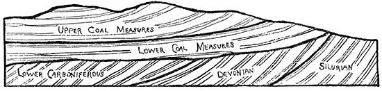
Figure 8--Actual relations of the Lower and Upper Coal Measures as now understood. (After Keyes, Iowa Geol. Surv., vol. 2, p. 162.)
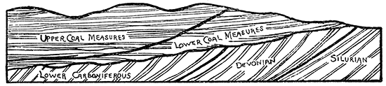
The conditions in Kansas will not admit of such a classification for the following reasons: First, according to the Keyes explanation, the later and consequently younger marginal areas would be landward from the earlier and older. But we have undoubted evidence that the land area for Kansas in Coal Measure time was the Mississippian to the southeast, while the later marginal areas are now found much farther to the west, as is illustrated by the Osage City shale beds and coal, which are from 100 to 120 miles west of the present western exposure of the Mississippian formation and almost as great a distance oceanward from the earliest marginal areas. Second, the universal westward thickening and eastward thinning of all the formations, as argued by Winslow, and pointed out in this chapter, is of such a nature that we cannot admit the earlier existence of the Coal Measure formations very much farther to the southeast than their present limits so that we cannot account for the marginal formations in the various places where they are known to exist in such widely scattered localities without assuming that there was a relative elevation of the coastal areas rather than a continual subsidence, as Keyes assumes. The Cherokee shales are marginal in their character, so are the Pleasanton shales, the Thayer shales, the Lawrence shales and the Osage City shales, each in turn being located continually farther oceanward and upward from the position occupied by the coast at the beginning of Coal Measure time. There is a strong parallelism between this and the relative positions of the outcroppings of the great geologic formations of America which are universally explained on the assumption of a gradually rising continent or a gradually subsiding ocean bottom. Third, one cannot make a careful study of the accompanying plates which represent sections run in so many different directions across the Coal Measures, and which for the representation of underground stratification are entirely dependent upon accurate records of so many deep wells, without admitting that each of the great formations, both shale and limestone, are continued uninterruptedly far to the west Fourth, any division plane of the Coal Measures which would pass diagonally to the stratification of the formations would be unnatural and would correspond in principle to passing a plane diagonally to the stratification lines which separate the Silurian from the Devonian, or the Devonian from the Mississippian. All of these latter great formations have portions within them which were marginal in origin and others which were formed under deeper ocean. But no one would entertain the thought of basing the greater classifications on such properties as these. The different formations in the Kansas Coal Measures lie as regularly one above the other as do the different formations in any great geologic group in America. The fauna of the successive limestone systems show a gradual transition in the forms of animal life from the ancient towards the more modern, which strongly indicate that all of anyone limestone system is older than those above it and younger than those below it. A division plane which would cut these diagonally would therefore be at variance with the accepted rules of time classification.
For all these reasons, and others which might be added, it seems that it is both unnatural and undesirable to divide the Coal Measures of Kansas otherwise than by a method at least similar to the one herein adopted.
C--The Permian
[Swallow: Prel. Rep. Geol. Surv. of Kas., p. 16; Lawrence, 1866.]
In the division of the Upper Carboniferous of the state considerable diversity has obtained in the usage of different geologists. Swallow places the base of the lower Permian at his number 84, the "dry-bone" limestone, already described in the Coal Measures. Meek and Hayden (Meek and Hayden: Proc. Acad. Sci. Phila., vol, 11, pp. 8-30; Philadelphia, 1859) are inclined to place the base of the Permian much higher than Swallow has done; while some geologists, notably Newberry, are inclined to discredit the existence of the true Permian in America (Newberry: The Work of the International Congo Geol., 1886, p. 29; also, Am. Jour. Sc. (3), vol. 30, p. 469; New Haven, 1885). It has also been suggested by some that a portion of the beds, the faunal contents of which are partially Coal Measure and partially Permian in character, be designated as Permo-Carboniferous, leaving only a relatively small portion of the Upper Carboniferous to be called the true Permian. Prosser has recently given an excellent and exhaustive discussion of the subject based upon two summers of field work in Kansas (Prosser: Classification of the Principal Paleozoic Rocks, Jour. of Geol., vol. 3, pp. 682-705, and 764-800). It is probable his conclusions are more reliable than those of any other writer on the American Permian, for he has devoted much more time to the field work than others have been able to do, and therefore he will be followed in this short discussion.
According to Prosser, the Upper Carboniferous of Kansas may be divided into two great groups, the Upper Coal Measures and the Permian, leaving out entirely the Permo-Carboniferous. He places the base of the Permian at the top of the Cottonwood formation, that is, at the top of the 14-foot shale bed immediately overlying the Cottonwood Falls limestone. The areal limitations therefore between the Upper Coal Measures and the Permian may be looked upon as corresponding with the eastern extension of the Cottonwood Falls limestone and is represented in this way upon the geological map accompanying this Report. Within the Permian Prosser makes the following divisions: First in the ascending order, the Neosho formation, reaching from the Cottonwood formation to the first general flint beds so well represented near Strong City and Fort Riley, the Wreford limestone of Hay in the Fort Riley section, figure 6 of this Report, and the fifth cherty limestone of Swallow, number 62, or the limestone No. 18 of Meek and Hayden. The total thickness of the Neosho formation is given as 130 feet Next above this he places the Chase formation, passing from the bottom of the flint beds just mentioned to the Marion concretionary limestone, a distance of 265 feet, and above this 400 feet to the top of the Carboniferous, which he calls the Marion formation, making an aggregate of 795 feet of Permian for Kansas.
Table showing the stratigraphic position and character or the formations comprising the upper Palaeozoic of central Kansas. After Prosser, Jour. oj Geol., Vol. III. p. 797.
| Period | Series | Formation or stage |
Stratigraphic character of the different eds | Characteristic fossils | Thickness of beds |
Total thickness |
Thickness of formations |
|---|---|---|---|---|---|---|---|
| Carboniferous | Permian | Marion (Prosser) |
Variously colored shales and marls. Colored shales arid marls alternating with beds of gypsum. Buff limestones and marls. |
250 ± | 1390 | 400 ± | |
| Abilene conglomerate. | 20 ± | 1140 | |||||
| Shaly buff limestones with Pleurophorus. | Pleurophorus subcuneatus, Bakevellia parva, Edmondia calhouni, nucula sp. | ||||||
| Buff limestones which contain large Lamelibranchia. | , Myalina permiana, Pseudomonotis hawni. | 1120 | |||||
| Grayish (?) limestones containing plenty of Bakevellia, near this horizon in some localities a concretionary limestone. Thin buff limestones with a few Derbya. |
Pleurophorus subcuneatus, Bakevellia parva, Schizodus curtus, Schizodus ovatus, Nautlus eccentricus, Yoldia subscitula | 130 | |||||
| Chase (Prosser) |
Marion concretionary limestone; containing large brown concretions. | Athyris subtilita, Productus semireticulatus, Derbya multistriata | 10 | 990 | 265 | ||
| Yellowish shales, free Brachiopods. | Athyris subtilita, Productus semireticulatus, Derbya crassa, Septopora fiserialis. | 13+ | 980 | ||||
| Marion flint; light gray limestone, generally containing flint. | Productus semireticulatus, var. calhounianus, Athyris subtilita, Archarocidaris sp. | 4 | 967 | ||||
| Variously colored shales with thin layers of limestone. | 62 ± | 963 | |||||
| Buff shaly limestones with Lamellibranch fauna. | Bakevellia parva, Pleurophorus subcuneatus, Aviculopecten occidentalis | 22 | 901 | ||||
| Fort Riley or Florence limestone, a massive buff limestone. | + | 879 | |||||
| Buff shaly limestones containing an abundant Brachiopod fauna. | Derbya multistriata, Athyris subtilita, Productus semireticulatus, var. calhounianus, Meekella striato-costata, Straparollus subquadratus, Derbya crassa, Meekella (?) shumardiana, Spirifer plano-convexa, Chastetes sp. | 15 | 874 | ||||
| Florence flint; a massive limestone with prominent layers of flint. | Productus semireticulatus, Chonetes granulifera, Derbya multistriata | 22 | 859 | ||||
| Yellowish chocolate and greenish shales. | 31 | 837 | |||||
| Light gray limestone with a fauna of small Lamellibranchia. | Pleurophorus subcuneatus, Bakevellia parva, Edmondia calhouni (?) | 2 ± | 806 | ||||
| Shales. | 12 ± | 804 | |||||
| Shaly buff limestone containing large Brachiopods. | Derbya multistriata, Aviculopecten occidentalis | 10 ± | 792 | ||||
| Shales. | 15 ± | 782 | |||||
| Strong flint; two strata of light gray limestone containing an abundance of flint in layers, separated by a massive whitish limestone. | Enteletes hemiplicatus, Athyris subtilita, Chonetes granulifera, Meekella striato-costata | 42 | 767 | ||||
| Neosho (Prosser) |
Yellowish shales with Brachiopod fauna. | Chonetes granulifera, Derbya crassa, Athyris subtilita | 23 | 725 | |||
| Massive gray limestone with Pleurophorus. | 3+ | 702 | |||||
| Yellowish shales with thin shaly limestones. | 36 | 699 | |||||
| Limestone with Pseudomonotis, at top and bottom, with shales between. | Pseudomonotis hawni. | 12 | 663 | ||||
| Green and chocolate-colored shales. | 20 | 651 | |||||
| Light gray shaly limestones containing Pseudomonotis. | Productus nebrascensis, Pseudomonotis hawni, Aviculopecten occidentalis, Pleurophorus subcostatus | 4 | 631 | ||||
| Shales. | 4 | 627 | |||||
| Dark gray silicious limestone, weathers to very rough surface | 2+ | 623 | |||||
| Yellowish shales with Brachiopods. | Chonetes granulifera, Productus semireticulatus, Rhombopora lepidodendroides. | 6 | 621 | ||||
| Yellowish, blocky shales containing a Lamellibranch fauna. | Pseudomonotis hawni, Aviculopecten occidentalis, Meekella striato-costata | 5 | 615 | ||||
| Greenish and chocolate shales. | 11 | 610 | |||||
| Shaly limestones. | 4 | 599 |
We will now consider the more strongly characteristic limestones of the Permian formation. The Neosho formation has it in but little of special interest excepting the heavy shale beds which are cut here and there by thin but persistent limestones. The one at the base of the formation weathers rough, recalling the properties so characteristic of the "dry-bone" limestone.
The Lower Flint Beds
First above the Neosho formation is an unusually heavy bed of limestone which is particularly characterized by the large amount of flint or chert that it carries. It might be stated in passing, however, that many of the limestones below this horizon are rich in flint; but the one now under consideration surpasses any and all of those below it in this respect. Along the Cottonwood river nearly one-third of its entire volume is flint; southward in the Flint Hills it carries an equally large proportion, and northward along the Kansas river perhaps as much as a fourth of the entire mass is flint. The limestone is heavily bedded and is so filled with fractures that it has no value for building purposes. At Strong City and other places it has been extensively crushed for railroad ballast, the fracture seams in both the flint and limestone greatly facilitating the crushing.
The Lower Flint beds first appear along the Kansas river between Manhattan and Ogden, along the Cottonwood near Strong City and on the western slope of the Flint Hills farther to the south. They cover a zone of country extending from north to south entirely across the state. In thickness they are variable. Hay gives them in his Fort Riley section as 25 feet; Swallow gives them as 12 feet; and Meek and Hayden give them as 40 feet. On the Cottonwood river at the quarries near Strong City, at the top of the hill, they measure 26 feet, and probably had been considerably eroded. Southward in the Flint Hills district they have greatly increased in thickness. It is quite difficult to correlate these beds with those given in Gould's section of the Flint Hills, but approximately they correspond to the two heavy limestone beds of Gould which are 34 and 47 feet thick, respectively, showing the wonderful thickening in that direction.
The Upper Flint Beds of Hay or Florence Flint of Prosser
Ascending from the Lower Flint beds through about 65 feet of alternating shales and thin limestones, along the Kansas river, and 112 feet along the Cottonwood, according to Prosser, and fully as far in the Flint Hills area, we find another heavy limestone formation carrying excessive amounts of flint. Along the Kansas river, according to Hay's Fort Riley section, but one limestone occurs in this interval; according to Swallow two or more are present; while Meek and Hayden give but one. Along the Cottonwood river two or more thin limestone beds are observed, and in the Flint Hills district five or six appear.
These Upper Flint beds are about 40 feet thick along the Kansas river, and increase southward to fully 75 feet in the Flint Hills area. They occur east of Fort Riley, from which point they are very prominent southward, passing-by way of Florence where they have been extensively quarried for ballast, and constitute the rocks on top of the hills along the eastern crest of the Flint Hills. They are fully as prominent throughout the zone crossing the entire state from north to south as the lower flint beds are as already described.
The Fort Riley, or Florence Limestone
Along the Kansas river, immediately above the Upper Flint beds, we find a 15-foot bed of shale, according to Hay, but one of only 5 or 6 feet thick according to Swallow, and Meek and Hayden. Along the Cottonwood river the shale bed is not to exceed 15 feet; and probably less. Southward in the Flint Hills it is possibly not quite so thick. This shale bed is of relatively little importance. Above it lies a prominent limestone from 6 to 10 feet thick which Hay calls the main Fort Riley ledge. It extends southward to the Flint Hills area, is prominent in the stone quarries at Florence and at intermediate points. It can be plainly seen along the line of bluffs in the vicinity of Fort Riley and many other parts of the state. Above it for a distance of 30 or 40 feet we have- principally limestones with thin shale partings irregular in thickness, so that the whole mass taken together forms one extensive limestone deposit. In places these beds carry considerable flint, but not nearly to so great a degree as do limestones of the Lower and Upper Flint beds already described. Above this mass of limestone and shale we have 50 or 60 feet of shale, then another 4-foot limestone, which carries so much flint that Prosser has named it the Marion Flint.
Aside from the palaeontologic importance of the beds above these there is nothing about them which specially attracts attention. In the upper portions the limestones are so few and the formations so thin that one is reminded strongly of the uppermost parts of the Coal Measures. Here and there gypsum is found occupying a place within the shale beds, in some instances to a very considerable extent. The uppermost portions of the Permian in the central part of the state grade into a mass of red clay shales of somewhat doubtful significance. Cragin (Am. Geol., vol. —, p. —; Minneapolis, September; 1895.) has described them under the new name of "Mentor beds." Along the southern part of the state over a considerable area, reaching from near the Arkansas river westward to Meade county, the so-called "red beds" cover the surface. It has generally been supposed they pass under the Tertiary and Dakota formations to the west and north. Recently Kirk (Unpublished manuscript, now in preparation, on the Salt Beds of Kansas) has found that the well records obtained from various borings throughout the salt-producing area extending from the south line of the state to as far north as Kanopolis, show that the "Red beds" reach northward in what seems to be unbroken extent throughout this whole distance. Dr. Sharpe also found during the summer of 1895 from as far south as the middle of Marion county to beyond the Smoky Hill river a bed of day shales, principally red in color, occupying a position between the uppermost Permian limestone and the massive brown Dakota sandstone. There is a possibility, therefore, that the "Red beds" so extensively developed along the southern part of the state pass northward under the Dakota sandstones to beyond the Smoky Hill river and constitute the beds described as "mentor beds" by Cragin. Investigations which are now being made by Kirk, it is hoped, will determine the matter.
The exact correlation of these "red beds" is somewhat a question of doubt. They have been called Permian by some, and Jura-Trias by others. This question will have to be settled ultimately by palaeontologic evidence, and as this Report is purely stratigraphic, making no pretension to palaeontologic discussions, no attempt will be made to decide such a mooted question.
It is also interesting to know that the salt beds so extensively developed in Kansas belong to the upper portion of the Permian. The recent investigations of Kirk have shown this so plainly that it seems there can be no doubt in the case. Well records have been obtained from many different parts of the salt region which, when drawn to scale and compared, show very conclusively that the salt beds lie above the heavy limestone beds, and below a bed of blue shale which in turn is below the "Red beds." As the blue shales so well developed in Sumner county and adjacent territory underlie the "Red beds," and as the latter are admitted to be the first above the Permian, it follows that the blue shales are Permian. But as the salt beds are below the blue shales, which approximate 300 feet in thickness, they are well within the Permian.
Ratio of the Permian Limestone to Shales
It seems that the proportion of limestones in the Permian is smaller in the northern part of the state and gradually grows larger until the Flint Hills area is reached, where more than half of the distance occupied by Gould's section is limestone. The general section given by Prosser is about 280 feet limestone and 515 feet of shale, or about one-third of the whole thickness is composed of limestone.
Inclination of the Strata in the Permian
Throughout the whole of the Permian formations the general inclination of the strata is to the west. On account of the excessive thickening in the Flint Hills area the maximum dip doubtless is to the northwest. This has been remarked by almost every geologist who has visited the country. In some instances over miles of extent the inclination reaches from 14 to 16 feet to the mile, but probably the average for the whole formations in the state is but little more than 10 to 12 feet. It is not known how far westward the inclination continues in this direction. The "Red beds" which immediately overlie the Permian are known to dip to the west as far as Great Bend, while the Cretaceous and Tertiary formations in the western part of the state are inclined to the east and northeast; but just where the division line is located between these two directions of inclination has not yet been determined.
Faults in the Permian
Faults are almost unknown in this formation, yet in the Permian rocks about a mile east of Chapman along the Smoky Hill river it seems that a double fault has been produced. Two limestone beds, the upper one 8 feet thick, the lower one 2 and separated by 6 feet of shale, have been broken and depressed, producing a wedge shaped fault, the vertical displacement being about 3 or 4 feet. This has been described by Adams in the latter part of chapter VI.
General Resume
In summing up the general conditions for the whole Carboniferous of the state above the Mississippian we find that the beds will aggregate about 3,545 feet in thickness, which may be divided as follows:
| Lower Coal Measures | 800 ft. |
| Upper Coal Measures | 1,950 ft. |
| Permian | 795 ft. |
Of this we have a grand total of about 820 feet of limestone and 2,725 feet of shales and sandstone, or a ratio of limestone to the whole thickness of 1:4.3. It should be clearly understood that perhaps no one point could be found under which the actual thickness of the whole Carboniferous would be quite as great as the figures above given. But, on the other hand, there can be no question but that this estimate is decidedly below the aggregate obtained by using the maximum thickness for the various formations as they occur in the state. Correspondingly by counting portions of the formations at one place and other portions at another we could make their thickness either greater or smaller than the figures above given. It may well be assumed, however, that on the highest hilltops a drill would have to penetrate about 3,500 feet to pass out of the Coal Measures.
Correlations with the Work of other Geologists
So far as the writer has learned, Swallow is the only geologist who has ever undertaken the construction of a complete section of the Kansas Carboniferous, and his work was of an, elementary character (Prel. Rep. Geol, Surv. of Kas.; Lawrence, 1866.). Meek and Hayden constructed a geological section along the Smoky Hill river from the Cretaceous down to the upper portions of the Upper Coal Measures, but did not at all attempt a complete geological column of the whole area (Geol. Expl. in Kas. Ter., by F. B. Meek and F. V. Hayden; Proc. Acad, Nat. Sci., Philadelphia, pp. 8-30, 1859). Since that date Mudge, St. John, Broadhead, Hay and others have added greatly to our knowledge of Kansas geology by publishing papers from time to time on the different phases of the geology of the state, the most of which have already been referred to in the earlier chapters of this Report.
The geological section constructed by Swallow was a great help in its day to the study of Kansas geology, but when a close comparison is made between it and the conditions as they are actually observed it is found that in many instances his correlations are greatly in error. For example, his Cave limestone, number 156, is given as occurring on Sugar creek and at Topeka; his Spring rock, number 162, is mentioned as occurring on the Marais des Cygnes, west of Topeka, and at Lecompton, and being below the coal, number 160, which occurs in Miami county; and still lower down, number 164, bituminous coal is given as occurring at the old Baptist Mission west of Topeka, while the blue shales; number 166, are mentioned as occurring west of the Baptist Mission and at Lecompton. Now, the facts are that the highest formations in Miami county, and therefore the coal, number 160, are several hundred feet below anything which may occur west of Topeka, while all of the materials about the old Baptist Mission and at other places west of Topeka are equally several hundred feet above Sugar creek and other localities mentioned, while Lecompton occupies an intermediate position not less than 200 feet from either of the other two localities, the one above it and the other below it. Again, his bituminous coal, number 176, occurring west of Lawrence, is placed about 120 feet below the Well rock, number 169, yet quite probably his Well rock corresponds to the Garnett limestone, and if so, instead of being 120 feet above the thin seam of coal west of Lawrence it should be about as many feet below. Passing on down to his number 184, a limestone is mentioned as occurring at Lawrence, although by his own figures it is 425 feet below the Well rock, or Garnett limestone, which in turn is fully a hundred feet below the river valley at Lawrence, making a vertical error of not less than 525 feet in this instance.
These discrepancies are mentioned, not to discredit the work of Swallow, for it was a great and good work and laid the foundations upon which nearly all of the subsequent geological investigations of the state have been conducted. They are mentioned merely to show why it has been found impossible for the present Survey to follow his section very closely regarding names and geographical localities.
Prev Page--Chapter VIII || Next Page--Chapter X
Kansas Geological Survey, Geology
Placed on web June 1, 2017; originally published 1896.
Comments to webadmin@kgs.ku.edu
The URL for this page is http://www.kgs.ku.edu/Publications/Bulletins/Vol1/chapt9.html