![]()
Prev Page--Chapter V || Next Page--Chapter VII
Chapter VI--A Geologic Section along the Kansas River from Kansas City to McFarland, Including a Section along Mill Creek
by John Bennett
| Section at Turner | Section at Argentine |
| The Lawrence Shales | The Oread Limestone |
| The Lecompton Limestone | The Deer Creek System |
| The Topeka Limestone | The Osage Shales and Coal |
| Buffalo Mound | |
| Comparison of Buffalo Mound Section with Meek and Hayden's Section | |
| General Remarks on the Stratigraphy of the Section | |
| Addendum, a Section from Manhattan to Abilene, by Geo. I. Adams | |
For the beginning of this chapter, and as a part of it, the reader is referred to the description of the section at Kansas City as given in chapter II.
No. 8 of that section, known as the Bethany Falls limestone, of Broadhead, has a fine exposure in the face of the bluff which juts out into the state of Missouri a short distance and forms the great ridge between the Kansas river and Turkey creek, This heavy system soon disappears below the hills westward after leaving the Missouri state line. Of No. 7 the same could also be said, for it is soon covered in the slopes, chapter II, and appears but once more, just west of Turner.
No. 6, however, has several good exposures on both sides of the Kansas river to the west. At Argentine 10 feet of it has been exposed by the grading of a street. The top of the exposure here contains much of the characteristic black chert. Above the middle of the exposure is a 16-inch stratum of blue limestone, below which the rock is not as cherty as at the top. This blue stratum is the cemetery wherein was buried the carapace of that large cephalopod, Nautilus ponderosus, several of which are in the State University museum, but which were taken from it at Turner, some three miles west. The second large exposure of this cherty rock was made by the Santa Fe railroad, at a cut one mile west of Turner, and six from the Missouri line. Here we find 11 feet of cherty limestone on top, then 4 feet of limestone with clay partings, then a clay parting of several inches, below which was 6 feet of fine grained dove colored and drab limestone, then a shale parting of a few inches, below which lay 9 feet of heavily-bedded limestone. Evidently Nos. 6 and 7 are together here. At Kansas City they are separated by but 4 feet of clay shales. In the correlation of the rocks of southeastern. Kansas we could scarcely hesitate to say that the equivalent of this cherty system is found in the upper rocks of the Erie system of the Marmaton section, plate IV, east of Bronson. The cherty system is seen in the Muncie hills of Wyandotte county, where there are strong evidences of an anticlinal affecting all of the rock systems under consideration. That is to say, the rocks dip towards Kansas City from these bluffs to the eastward, and in the opposite direction westward in common with other strata in the Coal Measures of Kansas. After leaving the exposure at Turner and the Muncie hills little more is seen of this cherty system, and it soon disappears below the valley of the Kansas river.
The Oolite limestone, or No. 5, although it has many outcroppings in and around Kansas City and the Muncie bluffs, in which places it has been extensively quarried, is not often seen on the south side of the river westward. One mile west of Turner is an exposure above that of Nos. 6 and 7. Here but 9 feet appears, and the upper 3 feet only is oolitic, the lower part being an irregularly-bedded gray limestone. It comes down to the railroad grade just east of Holliday, where it was last seen. The oolitic part of the system has everywhere its abundant and well preserved characteristic fossils.
Next above this is No. 4, a fine grained gray limestone, retaining a uniform thickness of about 9 feet wherever found. It has been extensively quarried in and around Kansas City on account of its good building qualities, although generally not even bedded. In the Turner exposure it is separated from No. 5 by 12 feet of shales, and has an exposure of 8 feet, the other foot being eroded away. At Holliday it has many croppings around the hills above the railroad tracks, and for some distance up the bluffs of Mill creek. At Bonner Springs, just north of Wilder, but on the opposite bank of the river, it is exposed between the Union Pacific railroad tracks and the river, and here has an abundance of Campophyllum torquium. This and the eroppings at Wilder are the last seen of it.
Section at Turner
To explain the conditions of Nos. 4, 5, 6, and 7, at exposures one mile west of Turner, we will here give the section at that place:
| 1st--8 feet fine grained irregularly-bedded limestone. |
| 2d--12 feet gray, blue, and buff nodular shales |
| 3d--9 1/4 feet oolitic and gray limestones |
| 4th--18 1/2 feet slope 11 feet black cherty limestone 3 inches clay parting |
| 5th--6 feet fine grained dove colored and drab limestone 3 inches shales 9 feet heavy-bedded limestone |
| 6th--6 inches clay parting |
| 7th--9 inches laminated limestone |
| 8th--3 inches buff shales |
| 9th--1 1/2 feet gray argillaceous limestone |
| 10th--2 feet bituminous shales |
Above this comes the "large fossil" limestone, and although but 5 feet thick it is well marked on the sides of the bluffs in and around Kansas City on account of its firm character. It is last seen near Corning, on the north side of the river, and east of Cedar Junction two miles on the south side of the river. Below it in their proper places were found several specimens of the little rare fossil. Conularia, crustula, already mentioned. Nowhere however has this fossil been found in such abundance outside of the Kansas City bluffs as at this exposure east of Cedar Junction.
Again ascending through 25 feet of shale. we come to No. 2, or the Iola limestone, the "heavy top rock" of Broadhead. At Kansas City, Mo., it forms the bold escarpment near the, top of the bluffs above the union depot and south of the Santa Fe railroad as far west as Argentine. It is found in the hilltops in Kansas City, Kas., and in the Muncie hilltops. Near the river just west of Argentine it has been eroded away, and is only found in the hills as they recede far to the south from the valley of the Kansas river. It again however approaches the valley before Holliday is reached and there forms rhe rough rocky face of the bluffs. West from Holliday it again recedes somewhat, but soon returns, and between Wilder and Cedar Junction forms the escarpment so plainly seen from the railroad all the wax. At Argentine it thickens up to 32 1/2 feet, and is extensively quarried for flux for the silver smelters of that town. The clay shales below it also thicken to 25 to 32 feet, as seen at the smelter rock crusher. Twelve feet down from its summit is 4 1/2 feet of nodular rock separated by shaly and loose clays abounding in the common fossils of the Coal Measures. At the quarry east of Argentine a mile or so and at Fifth and Barnett streets in Wyandotte it has the same characteristics, also at a quarry opened between Edwardsville and Bonner Springs On the north side of the Kansas valley. At Cedar Junction and De Soto this heavy limestone system comes down to the level of the valley, but can nowhere be measured in its entire thickness at those places. Along the north side of the valley between Loring and Lenape it forms a cliff 100 feet high. There are good reasons for believing however that the system above coalesces with it here. At the Edwardsville quarry they are not united, but are separated by the same amount of drab shales-6 feet, as at Argentine. The valley of Bull creek separates the Edwardsville exposure from the Corning and Lenape cliff by about five miles, and therefore we are in ignorance of where they come together, if they do at all. At Argentine their combined thickness including the shale separation would be about 50 feet, but at the Corning and Lenape cliff there seems to be a solid system, measuring from the valley to its summit 100 feet, and we know not how much it passes below the valley. An interesting fact is worthy of note here. The very perceptible narrowing of the Kansas river valley at this locality is due undoubtedly to the stubborn resistance of this rock in the fluviatile erosions of past ages. On the north side this whole system with the system above dips below the valley between Lenape and Linwood. The base of it is seen at Cedar Junction and the top section at De Soto. West of De Soto it dips under the valley, and where it disappears there seems to be a separation between it and the rock above, as indicated by benches and slopes along the hillsides. On Mill creek, between Olathe and Holliday, it has this same separating stratum of shale from the rock above, or our No. 1 of Kansas City, Mo., which we will now describe.
The arenaceous limestone, as has been said, retains its characteristics for some distance at least to the west. At the Edwardsville quarry it is well exposed, and between De Soto and Weaver, where it appears near the Santa Fe railroad, it seems to be a crumbling rock, although losing somewhat of its sandy nature. As has been hinted, the top of the Lenape cliff may be its equivalent.
We have now described all the important limestones as found in the Kansas City section with their disappearance to the west, the uppermost one going out of sight before Eudora is reached. That is to say that the very top rock at Twelfth street bluff, Kansas City, Mo., extends west some 25 miles before it disappears from view. The general dip in this distance would be about 6 1/2 feet to the mile, as the railroad rises 60 feet in this distance and the rock strata falls about 160 feet. Our next limestone system first makes its appearance three miles to the west of the state line, at Argentine, and caps the highest point of the hills there (see Argentine section, figure 2, page 51). The slope here of 45 feet above the last-mentioned rock represents it and the shales which underlie it. We will provisionally call it the "Syntrialasma" limestone, on account of the abundance of this fossil in it wherever it is exposed at Linwood, Leavenworth county, or at Ottawa, Franklin county, or north of Olathe, Johnson county, or at Eudora in Douglas county. At Argentine the limestone at the top of the hill did not seem to. have this fossil, leading me to think that it was a part of the system above the Syntrialasma rock. At Eudora there is but 5 1/2 feet of shales between it and the limestone above, and the parting is not over 15 feet at the park north of Olathe and perhaps less than that at Ottawa. The "Syntrialasma" limestone at Eudora and Linwood is but 6 feet thick, while north of Olathe it is fully 13 feet. Supposing this rock to be covered over in the slope of the Argentine section and that it was of the same thickness as its congener at Olathe then the 45-foot slope could be thus divided: Ascending there would be first 17 feet of shale then 13 feet of limestone (Syntrialasma rock) then 15 feet shales, thus reaching the limestone capping the hill, 3 feet of which has been left.
Section at Argentine
We now give the complete section at Argentine. Beginning at on the top of the hill at the city water-tank there is:
| 1st--3 feet of limestone |
| 2d--45 feet covered slope which must contain the Syntrialasma limestone |
| 3d--11 1/3 feet arenaceous limestone |
| 4th--6 feet blue clay and somewhat arenaceous shales |
| 5th--32 1/2 feet bluish gray, flesh colored and buff limestone--the Iola limestone |
| 6th--35 1/2 feet of buff, blue, and drab shales |
| 7th--1 3/4 feet limestone, in one layer |
| 8th--1 3/4 feet buff clay shales |
| 9th--3 feet gray limestone with calcite streaks |
| 10th--8 inches ochery clays and blue shales |
| 11th--8 inches gray limestone |
| 12th--1 3/4 feet gray clay shales |
| 13th--l foot light drab limestone |
| 14th--11 1/4 feet light drab clay shales |
| 15th--l foot chocolate colored, easily disintegrated limestone |
| 16th--3 1/2 feet gray shales |
| 17th--7 feet gray limestone somewhat oolitic |
| 18th--Clay shales 4 feet, then a slope of 40 feet |
| 19th--3 inches limestone |
| 20th--6 inches clay |
| 21st--10 feet black cherty limestone |
The "Syntrialasma" limestone while it may be and undoubtedly is in the tops of the hills to some distance south of the Kansas river valley, yet it was not seen until Weaver was reached. Here it appears in the low bluffs, and midway between Weaver and Eudora it comes down to the railroad cut and is well exposed. Here it is an even-bedded but brittle limestone 6 feet thick and lies on a bed of gray and drab shales with a foot or so of bituminous shales a little below its middle. On the north side of the valley three miles west of Linwood it has the same lithologic characteristics and is associated with like beds of shale. The upper layers of it are especially rich in well preserved fossils, of which Syntrialasma hemiplicata is most abundant. Terebratula bovidens come out of it in good condition and colored red, while Syntrialasma is a pure white. It also carries fine specimens of Bryozoa and Productidae, Productus longispinus being especially abundant, Athyris subtilita, Spirifer cameratus, Spirifer martinia and a Chonetes are among its organic remains.
The next limestone above it is 17 feet thick at Eudora and has been extensively quarried for ballast by the Santa Fe railroad. It is a rough rock both here and at Linwood, where it was also crushed by the Union Pacific company for ballast. It contains but few fossils here except the common forms. Just west of Eudora and up the Wakarusa towards Blue Mound it and its associate Syntrialasma rock dip out of sight. Before dismissing it however from our consideration we would call attention to the fact that immediately above the upper Eudora limestone there lies 3 feet of brown and somewhat calcified clay shales upon which lies 1 1/2 feet of thinly laminated limestone all of which might be added to the 17-foot system below it. It may be added that the "Syntrialasma" rock and the first one above it constitute the Garnett limestone.
The Lawrence Shales
We now come to a very heavy body of sandy and clay shales not less perhaps than 300 feet thick which have been called the Lawrence shales. The extensive valleys of the Kansas river and the Wakarusa have been excavated in them and the low hills in the neighborhood of these valleys are but the remnants of them. Just west of Fall Leaf station, on the north side of the river, the base of these shales assumes the form of a very firm sandstone which has considerable lateral extent, appearing in Blue Mound to the south of the river and among the hills farther to the south. In the bed of the river under the Lawrence dam there is a limestone nowhere else seen, unless it should prove to be a part of the, Eudora system. The general dip, as has been shown from Kansas City for twenty-five miles west, is 61 feet to the mile. This if continued would put the very uppermost section of the upper Eudora rock at least 40 feet below the railroad grade at Lawrence--the distance from the Eudora outcrop and place measured being nine miles in a directly east and west line. But the dip west of Lawrence is greater than east which change if begun before reaching Lawrence would put the Eudora rocks much farther below the city; and that seems to be a fact, as indicated by the record of a well-boring at Lawrence, as shown in plate VI. Above this limestone there is another thin limestone in the system of shales, perhaps not far from their middle, which has many croppings among the low hills east and south of Lawrence, and also in the country north of the river valley. It appears by the Santa Fe railroad track two miles northwest of Lawrence where it dips under the valley. Below it coal has been taken out in several localities. About 60 feet below the top of the Lawrence shales is another layer of coal, neither of which is very persistent, although in places each is of some value. The coal varies from 1 to 16 inches in thickness. Dark shales which undoubtedly grade into coal in places are also found near the summit of this shale bed.
The Oread Limestone
Ascending the hill at the State University we find near its summit a limestone system 12 feet thick which on exposure weathers dark buff. Between it and another heavy system above are some 16 feet of shale, near the middle of which lies a thin limestone stratum not often seen west of Lawrence, but assuming some importance in the high country north in Jefferson and Leavenworth counties. These systems have been named the Oread limestones in honor of Mount Oread, the hill on which our State University stands. To distinguish them we will call them the upper and lower Oread.
The lower Oread limestone disappears before reaching Lecompton, passing beneath low water mark at that place. It carries an abundance of the fossil Fusulina cylendrica and was the first rock in the section to contain in quantities this little Rhizopod. Athyris subtilita, Cyathaxonia distorta and Crinoid columns are among its fossils.
The upper Oread is largely developed and exposed at Lecompton where it has been extensively quarried for ballast by the Santa Fe company. It weathers dark brown like its associate, and all the limestones above it as far west as Topeka. The shales between the two Oread limestones retain their uniform thickness wherever seen, and are generally buff and olive clay chales. At Lecompton the upper Oread limestone is 22 1/2 feet thick, capable of subdivision as follows: Resting at its base are a few feet of bituminous shales, then 12 feet of heavy-bedded rock, the middle 2 feet of which is very cherty. Above this lies 1 foot of blue clay shales; then 6 feet of shelly nodular limestone with heavy clay partings abounding in well preserved fossils, and this again is capped by an even stratum 1 1/2 feet thick, separated from two layers above by 4 inches of clay, the top layers being 1 3/4 feet thick. On its summit lies a glacial gravel conglomerated by the cementing process of lime infiltration.
This limestone is a very interesting one to the paleontologist on account of its profuse and varied fossils. For that reason we will give here a complete list of all obtained from it: Fusulina cylindrica, two Bryozans, Fistulipora nodulifera, Chaetetes (?), two Crinoids, Archaeocidaris (?), Cyathaxonia distorta, Athyris subtilita, Spirifer cameratus, Spirifer lineatus, Spirifirena kentuckiensis, Productus prattenianus, Productus symmetricus, Productus americanus, Productus pertenuis, Productus costatus, Productus punctatus, Productus nebrascensis, Productus longispinus, Derbya bennetti, Derbya broadheadi, Meekella striato-costata, Syntrialasma hemiplicata, Terebratula bovidens, Retzia mormoni, Nucula ventricosa, Chonetes granulifera, Schizodus wheeleri, Chaenomya leavenwortheneis, Allorisma subcuniata, Allorisma granosa, Pinna peracuta, Edmondia (?), Rhynchonella uta, Chaenocardia (?), Monoptera (?), Macrodon (?), Aviculopecten (?), Bellerophon crassus, Bellerophon (?), two species of Nautilidae, Enomphalus rugosus, Orthis carbonaria, Campophyllum torquium, Pleurotomaria, two species, a branching coral, and other unidentified forms. At least 50 species were taken here in the quarry just east of the railroad station. This extremely interesting limestone is last seen about three miles west of Lecompton, where it disappears under the river valley, and takes with it its precious museum from which we regret to part company.
Above the last mentioned limestone lies a heavy shale deposit at least 97 feet thick at Lecompton. The lower 65 feet of this is a clay shale, then 16 feet of arenaceous shale, parted by a thin stratum of arenaceous limestone, then 5 feet of sand rock, above which lies 11 feet of sandy buff shales.
The Lecompton Limestone
Capping the hills around Lecompton is a 5-foot limestone in two layers, which we will provisionally name the "Fusulina" limestone, not that it alone bears that fossil, but because of the abundance of Fusulina in it. It is the lower of another triple system of limestones, the members of which are separated by a few feet of shale, and which retain this order as far as observed to the west. Above the "Fusulina" stratum are 5 1/2 feet of clay shales, then 1 1/2 feet of blue limestone which weathers dark buff like all its associate strata. Above this are 4 feet of shales having a bituminous streak in the middle, then 10 feet of light gray, easily disintegrated limestone. This group may be called the Lecompton limestone, on account of their outcropping being near Lecompton. At Spencer, six miles west of Lecompton, the upper of the series finally disappears below the alluvial soils of the valley.
The fossils of the Lecompton series merit little attention except the Fusulina of the lower bed. In the top of a hill at Lecompton, where the lower member was greatly weathered, this little foraminiferous rhizopod lay in such profusion that it looked as though some farmer had emptied his wheat sack in the soils.
Passing westward from Lecompton a slight difficulty was encountered in the correct understanding of the strata. The hills around Spencer were so covered with glacial material that the strata were principally concealed. One limestone was visible on a hilltop a mile south of Spencer, and which seems to dip westward and reach a relatively low position at Tecumseh. Two other limestones are also visible at Tecumseh, one of which forms quite a riffle in the river, and the other of which lies below it and forms a floor to the river for some miles below. The glacial material is so abundant between Tecumseh and Spencer that an error might easily be made in the correlations, but it seems that the section above the Lecompton series is as follows, counting upwards: First the thin layer in the bed of the river below the riffle about 40 feet above the Lecompton system; then 4 feet of shales, and then the riffle rock 3 or 4 feet thick; then 25 feet of buff clay shales with small lenticular bodies of limestone throughout it; arid then 2 feet of blue clay shales immediately under the top rock at Spencer above mentioned.
The Deer Creek System
We now come to what we may call the Deer creek systems, the bottom one of which may be the limestone seen in the top of the hill at Spencer, and is seen at a few places southeast of Tecumseh. The Deer creek exposure presents the following section, passing upwards:
First, 6 feet of fossiliferous unevenly-bedded limestone which was overlaid by 10 feet of shales, then a single-bedded limestone 2 feet, then 4 feet of drab and blue shales, and again 4 1/2 feet of limestone. These limestones were scarcely seen excepting in the Deer creek exposures. They disappear altogether two miles or so east of Topeka. But above them in the tops of the hills, and separated by about 60 feet of slopes, are remnants of the system above, or the Topeka limestones.
The organic remains were well preserved in the Deer creek system, and the following genera and species were noted: Productus altonensis ? (might be young of americana) were especially abundant. Bellerophon crassus was found here.
The Topeka Limestone
Coming now to the Topeka limestones, we find a quadruple series. In an exposure a mile east and a mile south of Topeka there is a showing of the upper section of the underlying shales. About 6 1/2 feet below the top of the underlying shales a fairly good building sandstone is reached which is 3 feet thick The lower limestone of the Topeka system is 6 feet thick, and is blue but weathers dark buff.
Above it is a foot and a half of blue shales, then above that 5 feet 8 inches of blue and brown limestone having a cherty layer near the top. Above this comes 2 feet of buff shales, and then again limestone 1 1/2 feet thick, above which are 3 feet of drab shales, which are again capped by 2 feet of limestone. The city of Topeka rests mainly above the cherty bed or second limestone in the series, yet here and there are, fragments of the third or thinnest layer in place. The cherty bed has been extensively quarried by the builders of the city in the past and quarries are now being operated near Shunganunga creek in the south part of the city. The Santa Fe and Missouri Pacific railroads have made a few exposures in the two upper limestones of the series just south of the city. In the various quarries a good opportunity was given to study the paleontology of this quadruple series. The fossils collected were: Fusulina cylendrica, Fistulipora nodulifera, Rhombopora lepidodendroides, Chaetetes and a romose unknown form of Chaetetes, Archaeocidaris ——, Zeacrinus mucrospinus and Zeacrinus acanthophorus, Fenestella ——, Chonetes granulifera, Productus punctatus, Productus longispinus, Productus costatus, Productus prattenianus, Athyris subtilita, Spirifer cameratus, Streptorhynchus crassus, Terebratula bovidens, Retzia mormoni, Bellerophon carbonarius.
The shales above the Topeka limestone could nowhere be accurately measured. At the brick-yard, three miles west of Kansas avenue, in Topeka, 28 feet of the upper part of the shales are exposed, and in a well close by we were told that 20 feet more had been penetrated before reaching the Topeka limestone. This would make them 48 feet thick, which we had good reasons for thinking was about correct. At the top of the shale lies 11 inches of coal, which has been mined in many places just west of Topeka, and which may be called the Topeka coal. Above it lies 2 1/2 feet of clay shales and then 2 feet of argillaceous limestone, then 6 feet more of shale and again 2 feet of gray limestone. These limestones although thin were persistent for several miles to the west, where they and the underlying coal disappeared under the valley. The only fossils of any importance in this double system was Chonetes granulifera, Fusulina cylendrica, a productidae, and Crinoid columns.
The Osage Shales and Coal
Four miles west of Topeka a section exposed in the railroad cut shows 26 feet of shales above the limestone system just described, and above them is a hard band of sand rock 2 feet thick which held its place until Lee's creek was reached, a mile and a half farther west. Beyond the creek at the sugar-works it was not seen. At the sugar-works, six miles west of Topeka, the coal and limestones above mentioned were all under the valley. Here the slope to the next limestone above was 91 feet from the Rock Island railway track, all of which seemed to be shales, but the exact thickness of the shale .below the track could not be told. A reasonable approximation would put it at 25 feet, making, a whole bed of 116 feet.
At the summit of the last mentioned shale there is a foot of coal, and immediately above it 21 feet of limestone. It is quite probable that this is the equivalent of the Osage coal, as it corresponds with it in general stratigraphic position. The fossils of this thin limestone are Chonetes granulifera, Spirifer cameratus, and Crinoid columns. Above this limestone is 30 feet of clay, shales and then 6 feet of limestone from which stone was obtained for the erection of the main building of the sugar-works plant.
A mile west of the sugar-works an exposure shows 21 feet of shale above the sugar-works limestone, and above the shale 5 feet of limestone. Three miles west of Valencia the sugar-works limestone disappears below the valley and is in the bed of the Kansas river a mile or so farther on at Willard on the Wabaunsee county line. At Willard the limestone above this thins out somewhat and becomes a good building stone blue in color on fresh surfaces. The fossils of the sugar-works limestone are Allorisma subcuniata, Meekella striato-costata, Productus pertenuis, Productus semireticulatus, Crinoid columns, a branching coral and a Bryozoan, Bellorophon carbonaria, and Myalina recurvirostris.
At Willard was met a change in the nature of the limestones. From Lawrence to this point all of them generally weather dark yellow, but here at Willard, on the borders of Wabaunsee county, the. limestones change to buff and weather quite a dirty yellow. At Willard about 25 feet above the blue ledge the first buff limestone comes in. It is but 2 1/2 feet thick and in places it is literally filled with a robust form of Fusulina. Productus semireticulatus, spines of the Echinoids, Meekella striato-costata and a Bellorophon were also found, in this limestone.
A sloping hillside--probably shale--of 50 or 60 feet brought us up to another limestone system 8 feet thick which abounds in the robust form of Fusulina, and is a yellow rock like the one before it. It also contains a large form of Lophophyllum proliferum. It disappears under the bed of Mill creek south of Maple Hill, and has a fine perpendicular exposure a mile or so east of Maple Hill on Mill creek. Above it and separated by 10 feet of arenaceous shale is a thin limestone stratum 1 foot thick. Then above that are 50 feet of sandy shales overlaid by 2i feet more of the yellow limestone which is largely made up of our little Fusulina cylendrica. This limestone forms the flat hills just east of Maple Hill on Mill creek and the low benches west of that village.
Buffalo Mound
Three miles southwest from Maple Hill is Buffalo Mound, over 300 feet high above the valley. Making our last mentioned or the fourth yellow rock in the ascending series our base at Buffalo Mound, the section would be as follows, counting downwards from the top:
| 1st--Top of Buffalo Mound a fragment of the Cottonwood Falls limestone |
| 2d--28 feet slope, probably all shale |
| 3d--Thin seam of limestone |
| 4th--42 feet slope, probably shale |
| 5th--Thick limestone system, but could not be measured exactly; probably 6 feet |
| 6th--26 feet slope, probably shale |
| 7th--Thin limestone |
| 8th--16 feet slope, probably shale |
| 9th--Thin limestone |
| 10th--11 feet slope |
| 11th--Thin limestone |
| 12th--16 feet slope, probably shale |
| 13th--Thick stratum of limestone (many crinoids) |
| 14th--45 feet slope, probably principally shale |
| 15th--Thin seam limestone |
| 16th--5 feet slope |
| 17th--Thin seam limestone |
| 18th--27 feet slope, principally shale |
| 19th--Thin seam limestone |
| 20th--16 feet slope, probably shale |
| 21st--7 or 8 feet of limestone in two systems, close together |
| 22d--73 feet slope, probably mostly shale |
| 23d--Fourth yellow limestone system |
| 24th--50 feet arenaceous shale, partly in valley below |
Figure 5--Buffalo Mound section.
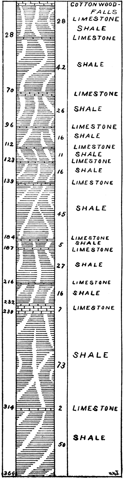
All these limestones have a light yellow color, becoming lighter toward the top. There is however one exception, and that is No. 13 of last section, which is a gray limestone holding many small crinoid columns. South of Paxico some five miles on Snokomo creek is a quarry in this limestone. Here it is in two even-bedded layers, and can be cut into pieces from five to eight feet long and any desirable width. It is said that it was used to a limited extent in the construction of the state-house at Topeka. In the shales above we gathered an abundance of very fine fossils on a creek farther to the west and just south of McFarland station. Here Fusulina cylendrica could be gathered by the handful; Chonetes granulifera were plenty, as were also the plates, spines and columns of Zeacrinus mucrospinus. Being hurried in this part of our Survey we had little time for collecting fossils. Evidently these rocks and shales are rich in the fauna of the upper Coal Measures.
Comparison of Buffalo Hill Section with Meek and Hayden's Section
On comparing the above section at Buffalo Mound with that made of it by Meek and Hayden, in the summer of 1858 [Pro. Acad. Nat. Sci. Philadelphia. vol. 11. p. 12], they note the prominent limestone beds of the above section, and in the order in which we have them, with the exception that they give greater elevation to the hill and correspondingly greater distances between the heavier beds of limestone. Our No. 13 they place at 160 feet down from the summit of the hill, while our measures are but 145 feet. We can scarcely be mistaken in the fact that the same limestone stratum is considered here, for it is the only gray limestone in the hill, and has its many columns of Crinoids, which mark it well paleontologically. Then our No. 21 and their No. 2 agree not only in characteristics but in being placed equidistant down from the numbers last mentioned respectively. Below this again our No. 23 and their No. 17 would seem to be equivalents, except that their No. 17 is 27 feet too low down, while their No. 12 would be about the right horizon geologically for our No. 23. We must admit, however, that the task of correlating these sections, is a difficult task, from the fact that so many thin strata of limestone exist in the shales of this region, and each of them standing out more prominently in one place than another it would be an easy matter to give note to any one stratum which might appear in one place and not in another. Their section, was evidently made on the north side of the hill, while ours was made on the long eastern slope. In the hilltop where they make a slope of 160 feet, we observed at least four thin strata and one 6-foot ledge. At the base of the hill they in turn observed several thin strata not observed by us.
Before reaching Alma four other limestone systems are to be seen in the high country east of that city. We can but mention them here about as follows: First, above the Cottonwood Falls limestone which is considerably thickened in the bold escarpment east of Alma there is a 45-foot slope, then a limestone, then 30 feet more of slope and again a limestone, above which 15 feet more of slope brings us another limestone, and then 20 feet to the limestone capping the hills. For want of time these latter limestone systems did not receive a critical examination.
General Remarks on the Stratigraphy of the Section
In reviewing the foregoing section a number of interesting points may be noted. At Kansas City the section is more than half limestone, and different limestone systems are very heavy, one measuring 30 feet in thickness, and increasing to much more in places. In the whole area east of Topeka we have four limestone systems that measure 20 feet or more. Westward the limestones become much thinner, and constitute a correspondingly smaller proportion of the section. From the base of the section at Kansas City to the base of the Lawrence shales we have about 300 feet which is fully one-half limestone. From the base of the Lawrence shales to the top of the Topeka limestone the total thickness is about 641 feet of which only 83 is limestone, giving a ratio of 1:6 2/3. West of Topeka to the Cottonwood Falls limestone we have a total thickness of about 760 feet with only 60 feet of limestone, or 1:11 2/3. Covering the whole of the section we find a total thickness below the top of the Cottonwood Falls limestone of about 1,700 feet with a little less than 300 feet of limestone, or a ratio of limestone to shale and sandstone of about 1:4 2/3. By adding to this section the thickness of the Coal Measures at Kansas City, as shown in plate II, a thickness of about 700 feet, we have a total thickness of the Coal Measure clays on the Kansas river below the Cottonwood Falls limestone of about 2,400 feet, of which about 375 feet is limestone and 2,025 feet shale and sandstone, giving a ratio of limestone to shale of 1:5 2-5. [Since the above was written by Mr. Bennett, the records of the Topeka and McFarland wells have been obtained, which show that the above estimates of thickness are too small--E. H.]
The color and texture of the limestone also gradually change, to the west. In the east the color is bluish on fresh surfaces and dark buff when weathered; to the west it becomes a light buff to a light cream, and almost white. To the east the texture is firm, to the west it is much more open and porous.
Addendum: A Section from Manhattan to Abilene
By Geo. I. Adams
In completing this section up the Kansas and Smoky Hill rivers to the limit of the Dakota there is little to present which has not been already described by earlier writers. Meek and Hayden, Swallow, St. John, and later Hay and Prosser have described the section in whole or in part, and Prosser has reviewed the earlier writings and compared them with each other and with the conditions as he found them. [Bul. Geol. Soc. Am., vol. 6, pp. 29-54.] The following section at Manhattan is taken from Prosser [Bul. Geol. Soc. Am., vol. 6, pp. 33.]:
| Section at Manhattan. (After Prosser) | |||
|---|---|---|---|
| Reservoir Level | Interval, feet |
Total, feet |
|
| 6 | Covered slope on Blue mount. At this horizon yellow shales Feet. containing plenty of fossils are exposed on mount Prospect, in the Uhlrich quarries up Wild Cat creek and at numerous other places about Manhattan | 10 | 215 |
| 5 | Manhattan stone--a light yellowish gray, massive limestone containing a considerable amount of chert, and in the upper part great numbers of Fusulina cylindrica, Fischer. In the quarry at the top of mount Prospect it is 5 feet 4 inches in thickness | 5 | 205 |
| 4 | Covered slope. On mount Prospect are shales, with some beds of laminated limestones about a foot in thickness | 40 | 200 |
| 3 | At the top a drab to bluish limestone of irregular texture which weathers very unevenly. This layer is between 2 1/2 and 3 feet in thickness on mount Prospect. On Blue mount it forms the first marked ridge, and the slope below the outcrop of this ledge is covered to the top of the road cut | 64 | 160 |
| 2 | Yellowish, bluish and blackish shales, with thin layers of argillaceous limestone (6 inches to 1 foot in thickness). The limestone in the cut near railroad level is somewhat bluish and contains fossils. The blackish shales near the top of the railroad cut at its southern end contain numerous fossils | 64 | 96 |
| 1 | Covered slope to level of Big Blue river | 32 | |
The most important of these strata is No. 5, the Cottonwood Falls limestone, which has already been described in connection with the Kansas river section. This with the accompanying beds may be easily traced along the river bluffs nearly to Fort Riley, there being a good exposure at Seven Mile creek and at Ogden. The connection between the Manhattan section of Prosser and the Fort Riley section by Hay has been made by Prosser, the Cottonwood Falls limestone being 122 feet below the first flint beds according to barometric measurement.
The beds of the Fort Riley section are found succeeding those of the Manhattan section just west of Ogden. The section at Fort Riley as given by Hay [Hay: Geology and Mineral Resources of Kansas, p. 8.; Topeka, 1893] is as follows:
| Fort Riley Section (After Hay) | |||
|---|---|---|---|
| Strata | Fossils | Thickness | |
| 14 | Impure limestones, with some flints and numerous geodes | A univalve | 10 feet |
| 13 | Light-colored shales, with lavender flag beds | Athyris, pecten, pleurophorus. | 50 to 60 ft. |
| 12 | Buff limestones with shale partings, Changing to shales with limestone ledges | Pecten, nautiloldea, athyris, meekella, hemipronites, martinia, fenestella, euomphalus, synocladia, schizodus | 30 to 40 ft. |
| 11 | The Fort Riley main ledge. A buff magnesian limestone in one thick ledge, with a thinner ledge resting on it. In places the ledges are continuous up into the layers of 12. | Pecten, allorlsma, martinia, athyris, retzia, hemipronites, synocladia, fenestella | 6 feet. |
| 10 | Shales, light colored and laminated | Producti, allorisma, chonetes. | 15 feet |
| 9 | The upper flint beds. Limestones containing numerous flint nodules, and separated by definite layers of flints | Producti, chonetes, allorisma, martinia | 25 to 30 ft. |
| 8 | Shales, alternate colors, gray, greenish, maroon, brown | No fossils | 30 feet. |
| 7 | Limestone. The mid-shale bed, varying from a laminated flaggy layer to a solid building stone four feet thick. | Planorbis, and another univalve, allorisma, meekella, myalina, hemipronites, producti, etc. | 6 feet |
| 6 | Shales, alternate colors, as No. 8 | No fossils | 16 feet |
| 5 | The lower flint beds. The Wreford limestone. Flints as in No. 9. Parts of the beds are silicified in localities as if by infiltration | Crinoids, syntrilasma, athyris, retzia, pinna, meekella, producti, cup corals | 25 feet |
| 4 | Shales. Bands of maroon and greenish gray, with a seam of coal on Humboldt creek. | No fossils | 16 feet |
| 3 | Limestone in cuboidal or rhomboidal blocks. In places oolitic. A seam of coal under it on Humboldt | 4 feet | |
| 2 | Shales and buffy slate. | 10 feet | |
| 1 | Slate, bluish and hard | Occasional discinae. | 10 feet |
Here again the section is marked by, a very prominent member, No. 11, which is the Fort Riley limestone. It gives character to the bluffs in the vicinity of Junction City, and is visible from the railroad on either the north or the south side of the river until it dips under the surface about three miles east of Chapman. The bed exposed on Indian Hill, just west of Chapman, is probably No. 14 of Hay's section at Junction City. Here the grading down of the wagon road has exposed a small flexure fault. A stratum of flinty limestone 2 feet thick shows a double fault, and a: portion of the main ledge which has been displaced vertically about 7 feet is lodged nearly in the plane of the flint bed. There are also other indications of a slight flexing and faulting in this vicinity.
Above this, the highest bed in the Fort Riley section, there is the following section which completes the Permian series to the border of the Dakota just west of Abilene, counting from the bottom upwards:
| 1. | Variegated shales, olive and maroon | 30 feet. |
| 2. | Thin-bedded limestone, exposed at Detroit | 22 feet. |
| 3. | Light-colored shale | 40 feet, |
| 4. | Limestone | 5 feet. |
| 5. | Shale | 25 feet. |
| 6. | Limestone exposed in north part of Abilene and in wagon road to Detroit, northwest of Abilene |
8 feet. |
| 7. | Shale | 40 feet. |
| 8. | Limestone, on hill at college north of Abilene | 3 feet. |
The Dakota does not rest upon the highest member of this series at this place, but crossing the creek west of Abilene it is found on lower ground. The sand springs west of town near four miles, and from which the water supply for Abilene is drawn, issue from under the Dakota as it rests on the Permian, probably No. 4 of the section just given. Fragments of the Dakota are found on the hill as far east as Fort Riley, but its eastern limit along this section is reached just after crossing the Superior branch of the Santa Fe railroad, in the western limits of Abilene.
Plate VI--A Geologic Section along the Kansas river and the Smoky Hill river from Kansas City to Abilene.
By Bennett and Adams; to accompany Chapter VI.
Scale: Vertical, 1 inch equals 500 feet; horizontal, 1 inch equals 5 miles.
The limestones are represented by the conventional masonry. The shales and sandstones are left bare.
The contours are principally those of the Atchison, Topeka & Santa Fe railway, the Chicago, Rock Island & Pacific railway, and the Union Pacific railway.
Available as an Acrobat PDF, 1.8 MB.
Prev Page--Chapter V || Next Page--Chapter VII
Kansas Geological Survey, Geology
Placed on web June 1, 2017; originally published 1896.
Comments to webadmin@kgs.ku.edu
The URL for this page is http://www.kgs.ku.edu/Publications/Bulletins/Vol1/chapt6.html