![]()
Prev Page--Chapter IX || Next Page--Chapter XI
Chapter X--Physiographic Features of the Carboniferous
by Erasmus Haworth
| Elementary Considerations | Absence of Composite Topography |
| The Kansas River | The Pottawatomie River |
| Tributaries of the Kansas River | The Neosho River |
| Absence of Composite Topography along the Kansas River | The Verdigris River |
| Life History of the Kansas River | Areal Topography |
| The Flint Hills | The Osage River |
The discussion of the physiographic features of the Carboniferous area has been delayed until after the general stratigraphy was given, contrary to the usual custom in geological reports, in order that the geology might be used to explain the physiography, which, for this area, seems more desirable than to use the physiography to explain the geologic structure. The workers in the field, however, early learned the relation between the two, and therefore constantly made use of whatever class of information they possessed for a given area to help them in the investigation of the other. Physiography was ~ften used in determining stratigraphy. Many an escarpment was viewed miles in the distance and the facts in its location used to determine points in stratigraphy. The greater the escarpment the heavier the shale beds were supposed to be, and in many other ways physiography was used to advantage while in the field. Also, known, facts in stratigraphy have been used in the study of the physiography; for, as the reader has already observed from the contents of the preceding chapters, each person while in the field made a careful study of the physiographic features of the area passed over.
Elementary Considerations
Before taking up the detailed description of the physiographic conditions it may be well to give a hurried review of such general principles in land sculpture as may be immediately applicable. Let us first consider the method by which a river reaches its base level when passing through slightly inclined alternating strata of relatively thick, soft material, such as shales, and thin, hard material, such as limestones, when the inclination of the surface is opposite in direction to the inclination of the strata. [Note: This term was first introduced by Powell in his Report of the Explorations of the Colorado River, 1875, p. 203, and has since come into general use.] Figure 9 will assist in this discussion. Let the original surface be A, A1, with the strata dipping to the left and the river flowing to the right. The first effect of the comparatively rapid current will be to wear away the soft material more rapidly than the hard, producing greater or lesser cataracts and falls at the points m, m1, m11, etc. But as the corrosive power of the stream will increase with the volume of water the work will be more rapid towards the mouth and will cut its channel through the distance A1, B1, while nearer the source it has only worn through the distance A, B. During the process the principal corrasion produced by the water will have taken place on the softer materials and the harder rock will be worn away principally by fragments, large or small, dependent upon the frequency of seams within the rock, falling after they have been undermined. In the course of time the, stream will have worn its channel to a depth, B1, beyond which it cannot go because it is now so nearly at sea level that the velocity has been so checked that further corrasion is impossible. Vertical corrasion will, therefore, cease at that point. Farther towards the source, however, the inclination is substantially the same as at the beginning, and the velocity will be sufficient to greatly corrode the channel and to provide the stream with large quantities of detrital material In this way the channel will be worn deeper to the left, until the condition of base level will gradually have receded, we will say, to the point B1a. Base level will, therefore, first be reached near the mouth of the stream but will gradually recede up stream as corrasion is continued until finally, should no other changes be introduced, the base level will have been reached throughout the whole length of the stream. It has been shown by Taylor and others that the form of the corrasion curve B, B11, B1, under ordinary conditions approaches a parabola.
Figure 9--Diagram showing the erosion of rivers, longitudinal section.
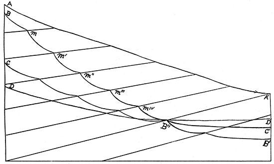
As soon as base level is reached at B1 the velocity will be checked to a sufficient extent to cause the current to unload a portion of the material it is carrying, and a filling-up process will begin, so that by the time base level has receded to B11 the filling near the mouth of the stream will have reached perhaps to C1. But with the erosion of the general land.area the continental portions will be worn down until the source of the stream will have a decreased altitude. This of itself would tend to decrease the velocity of the stream. By and by when the continental level has been reduced from B to C and from C to D, the checking of the current would have caused sufficient deposition near the mouth of the stream and along the lower part of its course to have filled the valley with loose material to a height of B1 the same valley which earlier in the life history of the stream was produced by corrasion of the current. The various cataracts and falls, m, m1, m11, etc., will gradually disappear as these conditions are brought about, partly by a change in the method of erosion and partly by the filling up of the gorges which have been worn out in the softer material just below the harder.
If we consider the condition at anyone time as the velocity is being checked it will be seen that the first material to be unloaded by the current would be gravels and the coarser sands. Later when base leveling had receded farther up stream a finer grade of sand would be deposited over the coarser gravel and this in turn by finer and finer material, until at the top of the filling the finest silt would be found. Therefore if the material which has been deposited by the river should be dug into at any point it would reveal a mass of coarse gravel at the base, no matter where along the length of the stream the examination was made. Many noted streams in different parts of the world are good examples of this condition. The amount of filling, the distance D1, B1, that will be produced along the lower parts of the stream will depend on many conditions. If the stream is a long one and its source greatly elevated, and should it pass over large areas of loose material, as the sands of the great plains, vast quantities of sediment will be borne downwards which can never reach the ocean on account of the checking of the velocity of the current, and which must, therefore, be dropped throughout the lower part of the valleys. But if the course is short and the source not greatly elevated and the materials over which the stream flows difficult to erode, the filling process below will not reach any considerable proportion. The Missouri river rising in the great mountainous district thousands of feet above sea level and flowing over the loose sandy plains has a strong velocity and readily becomes loaded with large quantities of sand and silt. As it progresses oceanward, however, the inclination of its channel is decreased until long before the Gulf of Mexico is reached its velocity has become so checked that it is compelled to deposit large quantities of the material which farther to the west it carried with relative ease. Other tributaries of the Mississippi and many other streams in America and elsewhere illustrate this principle on a grand scale.
With but few exceptions our streams in eastern Kansas have all reached the condition of base level, or the stage represented by D, D1, so that throughout the lower part of their course a filling-in process has been carried to considerable extent. This is particularly true of the Kansas river, the Osage river, the Marmaton river, the Neosho river, and the Verdigris river. At Lawrence the water company has made numerous borings in the river valley and has found that certain limestones and sandstones existing along the banks have been worn away and that the depth of the river valley at one time was 50 or 60 feet greater than it now is. The gravels in the lower portions of the filling are much coarser than those above, just as would be expected. In the coal mining operations at Boicourt it was found that the filling of the Osage valley had reached as great a thickness as that noted above at Lawrence, and with coarse gravel at the bottom. But below the silt and sand and gravel the regular stratified rocks were found. Borings at different places along the Neosho, particularly at Burlington, where a water-supply was sought, have revealed a similar condition. The old river channel has been filled in first with coarse gravel, then with finer, and finally with ordinary silt and, soil on top.
It is usually understood by the masses of the people that this filling-in process implies a lowering of the general level of the country where the filling has taken place. But it will be seen that such is not necessarily correct, as a filling of some kind is a necessary result and has occurred or must occur in the life history of every stream. Should there be produced a slight decrease in the altitude it will intensify the filling operation and in many cases where the increase of filling has been but little it will be difficult to recognize.
Let us now turn our attention to a study of the cross section of a stream which is flowing over materials similar to those assumed in the previous discussion. Prior to the time when base level was reached at this particular point the vertical corrasion of the stream would be so rapid relatively that the lateral corrasion need hardly be considered. Let us suppose the channel worn to a depth represented by a, a1, a, figure 10, at the beginning of our consideration. Shortly after it would have reached a condition represented by b, b1, b. The downward course would progress rapidly until base level was almost or entirely reached, when a condition similar to c, c1, c would be obtained. But now the vertical corrasion will cease and the slow but continuous process of widening the channel will become apparent. Let us now assume that the surface A, A1 is covered with a hard formation such as limestone, while the remainder of the materials represented are soft and friable shales. The widening of the channel will be produced principally by local rains, during which time the multitudes of little rivulets will carry materials into the river. If the hard layer did not occur at A, A1 the bluffs would assume rounded outlines, and the upper portions of them would recede laterally from the river much more rapidly than the lower. But the durable limestone covering at A, A1 prevents this. It will be worn away principally by being undermined so that block after block of it will fall below. In this way the walls of the bluff will be kept very steep if not almost precipitous.
Figure 10--Diagram showing the erosion of rivers, cross section.
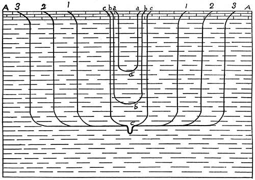
Lateral erosion is slow. The bluffs are worn away mechanically by the rains in times of freshets, and chemically by the percolating waters dissolving materials, so that every little spring, or even the surface rivulets which flow from the hillsides are constantly carrying away portions of the bluffs. But in geology time is long. The widening process will continue until the valleys of one stream coincide with those of its neighbors. During all this time the upper surface of the valley, B, B1, would maintain about the same level, provided general orographic movements do not interfere, excepting as the flood plain is gradually filled in with silt in times of overflow. Different Kansas streams have in this way produced valleys from three to five miles wide. It will be seen from this consideration that after a stream has reached its base level the quantity of water which it carries is of little importance in widening the valley. It is the amount of rainfall in any particular location, and the rapidity of corrasion produced by that rainfall, and the amount of materials carried away in solution by the percolating waters which determine the rate of widening. All that is required of the stream is that it carry away this local drainage.
But the lateral tributaries must also reach base level as well as the stream itself. The widening of their valleys will therefore progress about as rapidly as the widening of the valley of the larger stream. This is illustrated in hundreds of places in Kansas. The valley of the Wakarusa south of Lawrence is as wide as that of the Kansas river to the north, while some of the little tributaries to the Wakarusa not more than six miles long have valleys half as wide. The greater the number of lateral tributaries the more rapidly the general erosion of a district will be produced, for they so greatly increase the surface exposed to erosion. A tributary six miles long will have twelve miles of bluff. If its valley is three miles wide it has increased the bluff surface to fifteen miles, instead of the three miles of bluff were the tributary not existing, and the rapidity of the general erosion has been correspondingly increased.
The immediate river channel in all these wide valleys is from 10 to 30 feet below the surface of the valley land, and frequently the walls of the channel are almost perpendicular, as is shown in figure 10 at c. The existence of this particular channel is principally due to the solvent action of the water on the earth immediately in contact with it.
After a stream has reached its base level it usually. begins a process of meandering from bluff to bluff, thus occupying much greater space than would be necessary could it follow the direction it had before base level was reached. This condition is particularly well represented in the Kansas river and the Osage river near the eastern part of the state, and is less perfectly represented by the Neosho and Verdigris rivers throughout their course.
One other condition should be mentioned before passing. Let us suppose a river has reached its base level throughout a large part of its course, and has assumed a meandering direction. Later let there be a general elevation of several hundred feet throughout the course of the stream. This would increase the fall, and consequently the velocity, so that vertical corrasion would be renewed. Ultimately the stream would again reach its base level, and then the widening process would produce a new valley. We would therefore have two sets of bluffs, the one below the other, or a terraced condition, the intensity of which would depend on the abruptness and the height of each individual bluff. Such a terraced condition is usually considered good evidence of one or more periods of orographic movement since the stream first reached its base level. There is to-day a new physiography, or new physical geography, based largely on the interpretation of such conditions; for it will be seen that our river valleys and river bluffs have recorded in them the life history of rivers, and records of oscillations of surfaces since the streams came into existence, or since the continents were formed.
Having thus considered the general results produced by river erosion of materials similar to those composing the Kansas Carboniferous we may now extend the principles to the whole surface of the country. Figure 11 is a diagrammatic and condensed representation of the surface of eastern Kansas, together with the peculiar properties of the rocky crust of the earth upon which the contours depend. It represents a series of limestone systems approximately parallel dipping gently to the west and outcropping on a surface inclined towards the east. The intervening spaces are filled with shale or other matter which readily yields to erosion. The right hand limit of each limestone system therefore is marked by a terrace nearly as high as the distance downward to the next limestone; for, as already seen, the friable shale will yield rapidly and almost or entirely undermine the limestone mantle above, which in time will break away as it is undermined, thus allowing the terrace to recede westward.
Figure 11--Diagram showing the nature of the general surface erosion. (Kansas Univ. Quar., vol. 2, p. 132.)
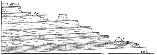
Often the limestones will have been fissured back of the terrace, as shown at band c, so that a valley has been cut between it and the main land, leaving a flat-topped mound standing alone. Such mounds are of most frequent occurrence, and give a picturesqueness to the scenery which cannot be described. The frequency of such geographic names as Mound City, Mound Valley, Twin Mound, Blue Mound, etc., tells its own story.
The walls of such mounds will always be steep, and sometimes almost precipitous, but their formation is easily understood, and is the same as that just given for river bluffs. Thus, the diameter of the top of mound b, figure 11, remains constant for a long period on account of the protecting influences of the rock at the summit. But the basal diameter is rapidly growing shorter, because the shale composing the mound so readily yields. Should one or more of the limestone systems have an outcropping many miles in length an escarpment would mark the outcropping throughout, the wall of which would correspond in shape and abruptness to the face of the mound.
The Kansas River
We will now enumerate the more important rivers which flow partially or wholly across the Carboniferous area, give their principal physiographic properties and discuss such other questions regarding them as may seem pertinent. The largest stream in the state is the Kansas river which is formed by the confluence of many tributaries; the most important of which rise in the extreme western part of the state, or just across the line in Colorado. Its valley is cut down through the various formations, so that the uppermost members of the Carboniferous are reached a little west of Abilene. The Permian rocks constitute the main mass of the bluffs from Abilene to Manhattan. From here to its mouth the river flows entirely through the Coal Measures. The bluffs just west of Abilene are low relatively, and, gradually receding, and are composed principally of the Dakota sandstones, which have but little variation of hardness throughout their mass. Below this both the Permian and Coal Measure formations are composed of alterations of limestone and shale, producing steep bluffs, which in extreme cases reach 300 feet in height.
A careful examination shows that the height of the river bluffs is quite irregular. Occasionally they come down to within 50 or 75 feet of the river, but either east or west rise again to much greater heights. Wherever such a low height is reached it can be readily seen that the limestone which dips to the, west is here lower than it is farther east, and that the first one above is well worn away at this particular place, but is found farther west capping higher bluffs. Topeka, Lawrence, and Eudora, each is a good illustration of this. At Topeka the uppermost limestone to the east has dipped until it is only about 75 feet above the river. The first limestone above has been worn away for a few miles farther back, but westward we soon reach the bluff protected by it, while to the east the surface rises with the limestone which is on the surface at Topeka. At Lawrence the Oread limestone extends eastward just to the west city limits. The Lawrence shales have been cut into about 200 feet, but there is practically no bluff on the south bank, as the Wakarusa valley joins the Kansas river valley here. A few miles below Lawrence the south bluffs begin rising, having for their protection the thin limestone shown in plates VI and VII as occurring about 150 feet below the Oread. By the time Eudora is reached in our journey eastward the Eudora-Garnett limestone has come to the surface, so that it forms a protection to the bluffs on both sides of the river. They are here less than 100 feet high, but gradually rise to the east on account of the limestone continuously assuming higher positions. This is easily recognized by anyone passing between Lawrence and Kansas City on either side of the river. The Eudora limestone may be traced all the way to Argentine, at which place it occupies a position about 250 feet above the river, with the bluffs correspondingly increased in height.
Disregarding, therefore, the channels cut by the lateral tributaries, we may describe the bluffs of the Kansas river from Kansas City to Manhattan as representing in profile a series of great steps, the floor of each one of which gradually dips to the west until it reaches a position much nearer the water level than it occupies farther east. The risers in this great stairway are the greater and lesser escarpments facing eastward which mark the eastern outcroppings of the successive limestone systems. Westward from Topeka a few miles, as shown in plate VI, the limestone systems become thin and moderately close together. There the vertical erosion of the river has exceeded the general areal erosion of the country, so that a larger number of limestone systems are worn through by the river without being removed from the surface of the country. Bluffs in this locality are high and much more retreating than farther below. But the river valley maintains its width so that the bluff lines are well marked, and their faces are composed of numerous little terraces each one of which is produced by the existence of one of the thinner limestone systems. Buffalo Mound, a short distance to the south from the river, in this way rises to a height of 300 feet or more above the river valley.
Only a few places can be observed in the river channel from Abilene to Kansas City where the limestone ledges are visible, in all the other instances the filling-in process having entirely covered them up. There may be no doubt, however, but that in the youthful period of the stream many cataracts and falls, some of them hundreds of feet in extent, lined the river from its mouth to at least as far west as the western limits of the Carboniferous. The great Lawrence shale bed nearly 300 feet thick would yield so readily to erosion that we may safely conclude the Oread limestones and the Lawrence shales caused cataracts and falls which rivaled in height and grandeur the Niagara Falls as we now see them. The high bluffs at Kansas City, likewise, composed as they are of such heavy beds of limestone with great shale beds beneath, probably produced similar falls in the Missouri river at or below Kansas City. Other places could be named, but these are the most striking. In fact some of the lesser tributaries of the Missouri and Kansas rivers have such falls still in existence although they are rapidly passing away.
Tributaries of the Kansas River
The Kansas river has numerous tributaries entering it from both sides. On the north Blue river enters it at Manhattan. It has cut its channel through the various systems of limestone and shale, so that its bluffs are as high and as precipitous as those of the Kansas river. The valley also is nearly as wide, but gradually grows narrower towards its source. Below Manhattan Mill creek enters the Kansas river from the south. It rises away to the southwest in the uppermost parts of the Permian. It has cut its valley through the various heavy limestone systems to about 100 feet below the Cottonwood Falls limestone. Throughout the most of its course its valley is relatively narrow, but its bluffs are similar in every respect to those of the Kansas river. At McFarland its south bluff is almost precipitous, rising to a height of 200 feet. The north bluff, however, is very receding, consisting of a gradual slope rather than a bluff proper, This condition is largely due to the particular character of the rocks which favors such a slope. Below this the next important tributary is the Delaware river, which enters from the north. It rises on the high divide separating the Kansas river from the Missouri. It has cut its channel into the surface to so great a depth that its bluffs in many places are as high as any known along the Kansas river. Its bluffs are remarkable for their precipitous character. Its valley is not as wide as the valley of the Kansas river, but in places towards its mouth it almost approaches such a width. This stream has not reached base level throughout the whole of its course, for in different places the water plunges over greater or lesser falls caused by the resistance to corrasion offered by limestone strata. The name, Valley Falls, of a town located on its bank implies this.
From the south the Wakarusa enters the river near Eudora. Its course is but little more than thirty miles in length and lies nearly parallel to the Kansas river, so that the drainage area between the two is narrow. The Wakarusa has cut its channel to a depth equalling that of the river, and throughout more than half its length the valley is approximately as wide as the Kansas river valley. On account of the sharp angle it makes with the river the upland between the two valleys has been worn away farther to the west than we find for the other tributaries. Lawrence is situated at the extreme southeast extent of the highlands between the two valleys. Just east of the city the valley from the north bluffs of the Kansas river extends southward to the south bluffs of the Wakarusa, a distance of fully fifteen miles.
Other smaller tributaries enter the river in many places, and also the various tributaries mentioned have their own lateral tributaries. The whole of these seem to have practically reached their base level. Those entering the Kansas river cannot deepen their channels until the river is in some way reduced to a lower level, while the greater portion of the smaller tributaries likewise have already cut their own channels almost as deep as will be possible. Many of the smaller streams have also widened their channels until in numerous instances a stream not more than ten or twelve miles long has a valley towards its mouth three or more miles wide. This is well illustrated by the little branch which enters the Wakarusa from the south, along which the Atchison, Topeka & Santa Fe railroad passes from Lawrence to Ottawa.
Absence of Composite Topography Along the Kansas River
Careful examination was made along the bluffs of the Kansas river and its various tributaries for indications of composite topographic features which would have resulted had there been any very considerable uplifting of the country in the environs of the source of the river after it had first reached its base level throughout the lower portions of its course. As was explained in the earlier pages of this chapter, when a stream reaches its base level and has widened its valleys a subsequent elevation of the drainage area will cause a second deepening of the channel, and a corresponding widening of its new valley after base level is reached a second time, which will result in the production of a terraced condition of bluffs. The meanderings of the stream during the period of the widening of its first valley would also be indicated in the more or less tortuous course of the second bluff line. If, therefore, such stages have been passed through by the Kansas river, we should find their history recorded in the character of the bluffs. Not a single instance is observable of a distinct approach toward a terraced condition in the bluffs of the Kansas river, or of any of its tributaries, excepting in the many instances where light terraces occur, each of which is plainly due to the existence of the hard limestone mass within the bluff. Such benches are always observable where there is more than one limestone system in the bluff. The width of the bench above the limestone rarely is more than fifty feet and usually but little more than twelve or fifteen, so that they could not be represented on a topographic map of ordinary character. This matter is one of great importance in connection with the geologic history of Kansas. Throughout the three seasons of field-work its importance was constantly in mind and observations as continuously made with an earnest hope to discover such terraced conditions should any exist. A general consideration of the bluff lines themselves also indicates an absence of composite topography. An examination of the topographic sheets issued by the United States Geologic Survey shows that the bluff lines of both river and tributaries are remarkably regular, there being no approach whatever to the sinuous directions the secondary bluffs would have assumed had they been outlined by the sinuous course the river assumed after it reached its first base level. This indicates that it will not do to assume that in past time the first set of bluffs produced has been entirely removed by the erosion.
Life History of the Kansas River
Both Professors Williston and Hay, as well as others, have shown that the principal tributaries of the Kansas river existed previous to Tertiary time, that they had worn great channels in the upper members of the Cretaceous rocks, and that subsequent to Tertiary time the channels assumed by the present tributaries correspond very closely with those occupied during pre-Tertiary time. Throughout the Carboniferous area there is no indication whatever of a change of location of any considerable extent having occurred anywhere in the course of the river or of any of its principal tributaries. [Note: Doctor Sharp, of McPherson, has probably found an old river channel at McPherson in the Dakota, an account of which will be published soon.] We may therefore conclude that its present location is substantially the same it has occupied during all of its existence since the general western uplift at the close of the Cretaceous time.
The question naturally arises regarding the cause of the location of the river along the particular course where it is now found. This can be only partially answered. As has been shown in the preceding chapters, the great persistency of limestone strata throughout the Coal Measures is accompanied by many gentle variations in dip, so that we have anticlinal ridges and synclinal troughs some of which extend over relatively large areas. The rocks on the south side of the Kansas river dip towards the north. At Lawrence there was previously a light dip towards the south throughout portions of the river valley, as is abundantly shown by the fact that the Oread limestones on the bluffs north of the river are a little higher than they are on the south. This can only be accounted for by the previous existence of a synclinal trough which possibly helped determine the primitive drainage channel. Also just above Kansas City we have a similar condition, rocks dipping northward on the south bank; and yet occupying slightly higher elevations on the north. These variations are slight, but wherever observed throughout the course of the river, they indicate that in its earliest stages the river channel was located along the synclinal troughs.
The Osage River
This stream rises in the vicinity of Burlingame and passes out of the state almost opposite Pleasanton. From Ottawa eastward it has a wide valley, and, in many places, high and irregular bluffs. The general character of the topographic features are practically the same as those described for the Kansas river. The bluffs are either low or high according to the present location of the protective limestone systems. In the vicinity of La Cygne and Boicourt where the Pleasanton shales are so heavy, with the numerous limestone systems close together above them, deep and wide valleys for the river and its tributaries result, while farther up stream, as the same limestone systems reach lower levels, on account of their westward dip, the bluffs correspondingly decrease in height. This has occurred to the greatest extreme in the vicinity of Ottawa, where the bluffs are little more than 50 feet high. A few miles to the west, however, the outcropping of the Oread limestone is met, and the bluffs correspondingly amount to nearly 200 feet. The widening of the channel of the Osage has not progressed to nearly so great an extent throughout the principal portions of its course as it has farther below. At La Cygne the valley is about four miles wide, with the river meandering from bluff to bluff in an exceedingly tortuous manner. At Boicourt Sugar creek valley unites with the Osage river valley, so that we have a condition similar to that already described at Lawrence where the Wakarusa valley unites with the valley of the Kansas river. But here the underlying limestone rises to the south very slowly, so that as one passes along the line of the Memphis railroad one seems to be in this low valley for twelve or fifteen miles. Here also it may be noticed that the Sugar creek valley is as wide as that of the river itself. This has plainly been brought about by erosion, the Osage river having long ago reached its base level to a point above the mouth of Sugar creek.
Absence of Composite Topography
An examination of the bluffs of the Osage and its tributaries was no more productive of indications of composite topography than has already been described for the Kansas river. Look where we will such features cannot be found. The bluffs in places have miniature terraces, but such terraces plainly are dependent upon the protective influence of local limestone systems. An examination of the topographic sheets also reveals a moderately straight and even direction for the bluff lines, at least an absence of the degree of sinuosity one would expect to find were the bluffs previously outlined by the meanderings of a stream which had reached its base level.
If we now look for an explanation for the Osage river, being located in the particular position it occupies, we find causes about as efficient as those mentioned for the Kansas river. As is shown in plate II, the limestone systems which cover the hills at Boicourt dip rapidly to the north to the bluffs at La Cygne, while beyond they rise to Fontana, This is one of the greatest synclinal valleys known in the state, and the Osage river at this place occupies the synclinal trough. It is true it has worn through the limestones, but in its earlier stage quite probably had its position determined by the limits of the synclinal producing a natural valley through which it flowed. Farther up stream nothing of the kind has been observed, but if the location was determined for the lower portions the upper parts would naturally have assumed the positions near where they are now found.
The Pottawatomie River
This stream is short but has a very interesting topography. It rises on the surface of the Garnett limestone to the west of Garnett. Its tributaries have cut through this limestone, and have eroded deep valleys into the underlying Lane shales. Its bluff lines are almost straight, its valley is relatively wide throughout most of its course, and its bluffs correspondingly high. One feature of the valley particularly should be mentioned; from Lane to near Osawatomie the valley proper seems to rise toward the east. This at first sight seems rather remarkable, but on closer examination it was found that the Iola limestone covered the whole of this valley. The higher Garnett limestone of course was worn through by the stream before its vertical corrasion had carried it downwards to the Iola limestone horizon. The check in rapidity of vertical erosion due to, the Iola limestone gave time for lateral erosion. In this way the widening process of the valley above the Iola limestone was far advanced before the river had cut through the latter. As one passes from Lane to Ottawa one will notice that the valley proper lies above the Iola limestone and is four or five miles wide, but the river has now cut through the latter limestone and the widening process of its second valley is in its incipiency, having reached a mile or more in the vicinity of Osawatomie. In this way there is an approach towards two bluff systems which might be mistaken for a change of level in the upper parts of the stream, causing it to reach a base level a second time. Brit the true explanation is that just given.
The Neosho River
This stream rises in the central part of the state on the uppermost portions of the Permian as it is now exposed. It flows in a general southeastern direction, making a gradual curve until it passes out of the state flowing almost south. The topographic features along this stream are not so pronounced as those described for the Kansas and the Osage rivers, but they are equally interesting. Where its direction is approximately at right angles to the line of outcropping of the different formations the bluffs are about equal in height on either side. But as it changes its relative direction the south bluffs in places are less pronounced than the north. It would seem that this is due to the gradual rising towards the south of the different limestone formations, while towards the north the upturned edges of the same formations would be eroded in such a way as to produce more nearly vertical walls. Farther downwards, when the stream breaks through the line of outcropping of the Oswego limestone, the east bluff line. which is in the Cherokee shales has melted away to a gentle slope receding four or five miles from the river, while on the west the protective influence of the Oswego limestone has caused a bluff to exist at Oswego which in places is almost vertical to a height of 150 feet. The general features, therefore, of the topography of the Neosho river are easily explained by the particular geologic conditions of the country over which it flows. The direction of the bluff lines is more curving than we have heretofore found for the other streams, but nowhere do they approach a sinuosity such as streams assume after they have reached their base level. On the contrary the curves are bold and gradual, implying that they are due to the general surface features which determine the directions the river should follow.
The Verdigris River
The Verdigris river rises in the Coal Measures proper not far from the southern limit of the Neosho drainage area. Its direction in the state is almost south. It has cut its channel through the Garnett limestone, the Iola limestone, and the Independence limestone, and has reached its base level almost to its source. From Benedict almost to Neodesha the Iola limestone serves as a protection for the bluffs on both sides of the river, while below this they cap the bluffs on the west to almost opposite Independence. The height of the bluffs throughout this distance gradually increases to the south; at Benedict they are about 75 feet high, while near Neodesha they are nearly 200. Below Neodesha the river reaches the Independence limestone, and the Thayer shales permit the eastern bluff to recede from the river in a gentle manner similar to the eastern bluff of the Neosho at Oswego, while the Iola limestone causes the western bluff to be almost precipitous, but it has receded six miles or more from the river. Farther below, where the river has cut its channel through the Independence limestone, the bluffs protected by the Iola limestone gradually assume positions farther to the west of the river, so that at Independence they are four or five miles away. The elevation of the Independence limestone is but a little above the base level of the river at Independence, so that the river valley practically reaches to the surface of the Independence limestone, producing a sequence of conditions similar to those described for the Pottawatomie river valley between Lane and Osawatomie.
Areal Topography
Having given in considerable detail the topographic features along the principal rivers of the state, we will now turn our attention to the general areal conditions of the high uplands between the various streams. Let us again, refer to figure 11 which has already been explained. It approximately represents a cross-section of the general areal conditions. Here and there where ever there is a line of outcropping of an important limestone system there is a more or less pronounced escarpment facing the southeast. The vertical height of such escarpment is dependent almost wholly upon the thickness of the shales which underlie the limestone; Wherever two limestone systems approach each other vertically by thinning of the separating shale beds the two escarpments correspondingly diminish in boldness. This is well illustrated in the line of escarpment which reaches from La Cygne and Boicourt away to the southwest. As has already been pointed out in chapter IX, the walls of this escarpment vary in height from place to place as the thickness of the Pleasanton shales varies. Farther to the southwest the Erie limestone series is separated by the thickening of the intervening shale beds, and each one in turn has its own escarpment, as is so well marked in the vicinity of Mound Valley and Cherryvale. If one will pass across the country from the southeast towards the northwest one will be continuously passing up a series of terraces similar to those represented in figure 11.
If the escarpment is bold and the underlying shale bed is thick, a series of mounds always exists to the southeast of the escarpment proper. These have plainly been produced by the erosive agents breaking through the protecting limestone farther to the west. Such mounds sometimes are large, with broad flat tops, as is so well illustrated by Table Mound described by Adams in chapter I; sometimes they are small like the frustums of cones, as is so beautifully illustrated by the mounds in the vicinity of Cherryvale and Mound Valley. In both these places the protective limestone is still maintained on the summit, as shown at b, figure 11. At other times the surface limestone has gradually been worn away until the mound consists entirely of masses of shale which may have a little sandstone interspersed. In these cases the summit of the mound will generally become rounded, as shown at a, or d, figure 11. Illustrations of this class are common throughout the country.
By referring to chapter IX it will be seen that above the Cherokee shales we have two particularly heavy shale beds, the Pleasanton shales and the Lawrence shales, and also that some other shale beds, such as the Thayer shales and Lane shales, in places assume considerable thickness. It is interesting to note how the great areas of mounds and escarpments coincide so exactly with the southeastern limits of these shale beds. Beginning at La Cygne and Boicourt, we have an area characterized by mounds and steep bluffs reaching to the southwest by way of Mound City, Uniontown, Cherryvale and Mound Valley to beyond the limits of the state. Above this we have the Thayer shales, which produce a similar topography in the vicinity of Neodesha and Independence. Passing upwards another similar condition is reached where the Lane shales come to the surface, so that from Osawatomie to the southwest by the way of Lane, Greeley, and Garnett, we have quite similar physiographic features. Then above this, where the Lawrence shales are most heavily developed, the same conditions are repeated. At Lawrence, Blue Mound stands off five or six miles to the east of the general outcropping of the Oread limestone with its protective cap of limestone nearly removed by erosion.
One cause which intensifies these physiographic features is the various tributaries of the principal streams cutting the channels through the overlying limestone. In this way a deep and wide valley with high bluffs may extend far into the interior beyond the limits of the river bluffs, and may repeat the features already described as characterizing the eastern faces of the great escarpments. A good illustration of this is found along Sugar creek, which rises to the southwest of Mound City. It has cut through all the overlying limestone a hundred feet or more into the Pleasanton shales throughout almost all of its course. Along the walls of its bluffs, therefore, we find mounds and promontories reaching out into the valley similar to those of the various general escarpments already described.
We find but few broad gentle rolling areas anywhere within the Carboniferous. The tributaries to the different streams have cut the whole country into valleys, and the residual portions which are not carried away by erosion constitute the hills, so that usually there is such a succession of hills and valleys that the whole country is not only well drained but moderately rugged. One can travel many miles in the direction of these ridges almost on a level, while perhaps in a transverse direction one or more deep valleys would be found every mile. The great Cherokee shale area in Cherokee and Crawford counties is an exception to this general rule. It is almost level throughout, there being a significant absence of any considerable hills or highlands within it, excepting in a few places where the Columbus sandstones have assumed considerable proportions, so that they serve as a protection for the underlying shales.
The general physiographic features of the Permian are similar to those of the Coal Measures. The river drainage valleys are as deep, and their bluffs as high as can be found anywhere in the Coal Measures. The only distinguishing feature that is readily apparent is the absence of the great escarpments over the general uplands, as have already been described for the eastern limits of the heavier shale beds below, such as the Pleasanton shales, the Thayer shales, the Lane shales, and the Lawrence shales. Throughout the Wabaunsee formation and the overlying Permian the absence of such heavy individual shale beds makes such great escarpments unknown; but lesser ones are very frequent. In the vicinity of the great drainage valleys where the streams are cut so deep, passing many limestones in succession, the bluffs are usually most beautifully terraced, the horizontal distances between the, terraces generally being small and the limitations very evidently being controlled by the limestone formations themselves.
The Flint Hills
Few localities can be found the physiographic conditions of which better illustrate the relations between stratigraphy and physiography than the Flint Hills area. Westward from Independence along the southern part of the state for some distance a sandstone area prevails. The Niotaze well, for example, passed 800 feet below the surface before limestone was reached. The limestone formations below this dip to the west until they are beneath the surface in this locality so far that they have not retarded erosion. From the vicinity of Independence westward, therefore, the whole surface of the country along the south line of the state has been composed of materials easily eroded, which accounts for the unusually low altitudes in the vicinity of the Verdigris river and to the west. But when the Flint Hills area is reached the heavy massive limestones, rendered more durable by the interbedded flints, resisted decay to such an extent that they have been affected only mildly by the corrasive agents. Westward from this area again we find an absence of hard materials; the strata dip rapidly to the west; many of them pass under the Arkansas river, leaving at the surface the soft, easily eroded sands and shales. It is therefore the most natural condition that the great Flint Hills area should now stand out prominently from the surrounding country to the east and the west, having been left behind while the adjoining materials were chiseled away, a result of the peculiar formations which exist throughout that area. The sides of the hills have as a consequence become very steep. This in turn has given greater corrasive power to the various little streams rising in the territory, which in turn have chiseled deep gulches on every side simulating in character and extent the gulches on the sides of more pretentious mountains. The very formations which have caused this peculiar physiographic condition grow thinner to the north so that they have a less elevation, and the sandstone area to the east disappears entirely before we pass very far northward from the south line of the state, so that the great abruptness on the east side of the Flint Hills gradually declines as one travels northward, until it practically entirely disappears and the customary series of terraces and escarpments so common in the Coal Measure area takes their places.
The Carboniferous of Kansas is therefore a great plain the surface of which has been cut into valleys and streams and into great escarpments on the uplands. Wherever we look there are ever-changing scenes before us, scenes dependent in origin on the combination of stratigraphic conditions, surface inclination, and the erosive action of the elements, yet scenes which are pleasing to the eye and satisfying to the mind on account of their ever-varying beauty and suggestive nature. They are the smooth and even poetry of nature rather than the rugged and the strong. They suggest greater scenes, higher hills and deeper valleys, because they are such, only in miniature.
"They lack the overpowering immensity of the vast erosions of the west. They do not stagger our imagination by the magnitude of the phenomena. So, as well, they do not discompose our study with sentiments of awe and wonder. They lie within the range of easy comprehension. They are unimpassioned lessons on the methods by which the once expressionless face of the land was carved into pleasingly diversified relief."
[Chamberlin and Salisbury: Sixth An. Rep. Director U. S. Geol. Sur., p. 224.]
Plate XXIII
A mound one mile south of Cherryvale. This represents the process of erosion with a thin limestone bed lying above a heavy shale bed. The limestone is plainly seen at the top of the mound (the Independence limestone), and the perfectly flat top which it has is due to the protection or the limestone cap. The bare places on the sides of the mound are places where the weathering away of the shales is so rapid vegetation cannot get started.
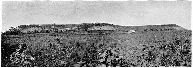
Plate XXIV
A portion of the row of mounds one mile north of Cherryvale. The same limestone, the Independence, protects the summit of this mound which was shown in Plate XXI. Here the degradation of the shales on the south side of mound is more rapid than that in Plate XXI, and there is correspondingly a larger portion of the hillside void of vegetation.
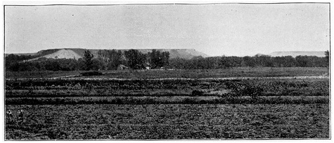
Plate XXV
A row of mounds beginning about three miles south of Cherryvale and extending towards Coffeyville four or five miles farther. The summits of these mounds are protected by the Independence limestone, the same one shown in Plates XXI and XXII. Near the left end of the figure one of the mounds is seen plainly standing out by itself, from which the protecting limestone is entirely removed, and which is already beginning to assume the rounded form produced by the weathering of soft materials.
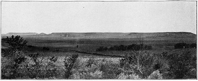
Plate XXVI
The southern portion of the bluffs west of Pleasanton. Here we have an escarpment produced by the combined influence of the heavy Pleasanton shales and the bed of Erie limestone lying above which serves as a protection the same as that shown in Plates XXI and XXIII.
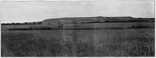
Plate XXVII
A scene on the Kansas river, near Lawrence.
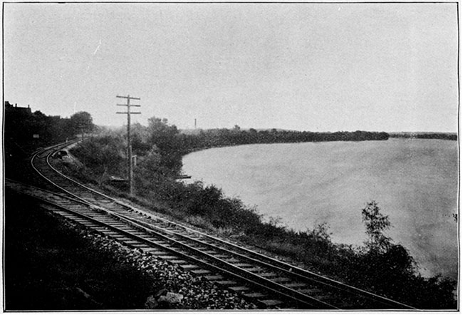
Plate XXVIII
Blue Mount, Manhattan. This represents the eastern extremity of the high escarpment just north of the city of Manhattan. The Blue river passes to the right, and the Kansas river on the south. The high bluff is protected by the Cottonwood Falls limestone, as shown at the summit in the left hand part of the figure. This protection has been worn away near the middle of the figure and the valley has begun forming, which in the course of time will cause the right hand portion to become an isolated mound.
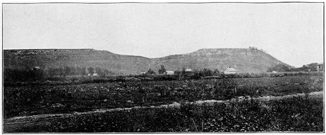
Plate XXIX
A scene along the north bank of the Kansas river, about six miles west of Manhattan.
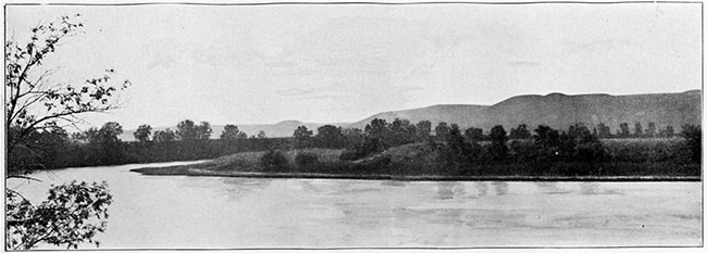
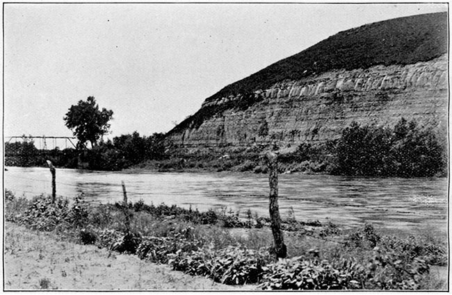
Plate XXX
Republican river bluff at Wakefield. This shows the Permian limestone on the bluff on the west bank of the Republican river about one-fourth mile above the village of Wakefield. The stratification of the heavy limestone beds is well represented and the surface soil and gravel above.
Prev Page--Chapter IX || Next Page--Chapter XI
Kansas Geological Survey, Geology
Placed on web June 1, 2017; originally published 1896.
Comments to webadmin@kgs.ku.edu
The URL for this page is http://www.kgs.ku.edu/Publications/Bulletins/Vol1/chapt10.html