![]()
Prev Page--Introduction || Next Page--Chapter II
Chapter I--A Geologic Section from Galena to Wellington
By Geo. I. Adams
| The Mississippian Series | The Thayer Shales |
| The Cherokee Shales | The Iola Limestone |
| The Oswego Limestone | The Elk Falls Area |
| The Pleasanton Shales | The Flint Hills |
| The Altamont Limestone | The Wellington Area |
| The Mound Valley Limestone | General Section |
| The Independence Limestone | Addendum to chapter 1 |
| Geologic Section across the Flint Hills along the Missouri Pacific railway, beginning near Cedarvale and extending to Winfield, by C. N. Gould |
|
This section begins at the state line in the eastern part of Galena. Here, the Mississippian or Sub-Carboniferous ore bearing limestone series is exposed and for a few miles to the west. The surface declines rapidly towards the west to Spring river, a distance of about three miles, beyond which it rises again slightly and reaches the Coal Measure formation about four miles from the state line.
The Mississippian Series
This series consists principally of a dense, crystalline limestone carrying excessive quantities of chert, or flint rock, which is very irregularly disseminated through it. In places it is partially composed of shale, but the limestone and chert are the characteristic constituents, as is abundantly shown throughout the lead and zinc mining region about Galena, Joplin, and other mining towns.
The surface of the Mississippian series is quite irregular, indicating a long period of erosion between Mississippian and Coal Measure time. [Haworth: A Contribution to the Geology of the Lead and Zinc Mining Districts of Cherokee county,.Kansas, 1884. Transaction Kas. Acad. Sci., vol. 8, p. 13. Kansas Univ. Quar., vol. 2, p. 126. Hay: Geological and Mineral Resources of Kansas, 1893, p. 5.] This irregularity is shown in. two ways.
At different places in the vicinity of Galena and further east, in Missouri, numerous residual patches of Coal Measure rocks still exist, Some of them are preserved by hard superficial layers, but others owe their present existence to basins and valleys cut in the Mississippian rocks by erosion before the Coal Measure rocks were laid down. Into all such depressions the latter were deposited and have been protected sufficiently to preserve isolated patches to the present time. The opposition of this condition is noted in the hills or prominences of the Mississippian within the Coal Measures and abundantly shown in many places near the eastern limit of the latter. A few of these will be mentioned. On the high ground along the western line of section 7, township 33 north, 25 east, a well only 23 feet deep reached the Mississippian, while numerous wells of about the same depth on much lower ground to the east did not pass through the Coal Measures. Along the north line of section 12, township 33 north, 24 east, an exposure of the Mississippian covers two or three acres, while equally low ground to the east shows none of it. Six miles back from the boundary, or within five or six miles of Columbus, the Mississippian is exposed at the surface, or is reached in shallow wells over an area of four or five square miles. The rocks here so closely resemble the ore bearing rocks at Galena, that on different occasions miners have spent considerable time here in prospecting for lead and zinc ores. It would therefore seem that here in Kansas, as in Missouri [Winslow: Missouri Geol. Rep. vol. I, 1891] and Iowa [Keyes: Iowa Geol. Rep. vols. 1 and 2, 1893, 1894] there exists a marked nonconformity between the Mississippian and the Coal Measure, a nonconformity due principally to the, surface erosion of the former before the latter was laid down.
The surface of the Mississippian dips to the west along the line of this section at about 20 feet to the mile. By referring to plate I it will be seen that the surface of the highest hills at the state line is about 975 feet above sea level. The deep well at Oswego reached the Mississippian at a point about 400 feet above sea level. The wells at Stover and Mound Valley went to within 330 and 60 feet respectively of sea level without striking it; while the one at Cherryvale reached it at 180 feet below sea level. The distances to Oswego and Cherryvale are 27 miles and 54 miles respectively, with a dip of 21.6 and 21.4 feet to the mile, or an average of 21.5 feet for each place. Other deep wells further to the north and west at Neodesha, Fredonia, Thayer, etc., give similar results. Still further west a well at Wichita was sunk 1,950 feet without reaching it. From the general inclination of the surface rocks it may be inferred that westward from the Verdigris river the dip gradually decreases, but as no deep wells are recorded which have reached the Mississippian nothing definite can be stated.
Later in this chapter, in calculating the thickness of the Coal Measures, it is assumed that from Elk City west the inclination gradually decreases to about 10 feet per mile.
The Cherokee Shales
[Haworth and Kirk: Kansas Univ. Quar. vol. 2, p. 105; Lawrence, 1894.]
Immediately above the Mississippian lies the great bed of Cherokee shales. This is by far the heaviest and most important shale bed in the Coal Measure area of the state. It is about 450 feet-thick, as shown by borings at Oswego, Girard and Fort Scott. The borings at Stover, Mound Valley, Cherryvale and Independence, all of which are drawn to scale on plate I, show that it maintains this great thickness westward to a remarkable degree, probably underlying the whole of the Coal Measures.
The Cherokee shales contain many beds of sandstone which are extensively used for building and flagging stones, They contain the most extensive and valuable coal deposits in the state, both as regards amount and quality, and they also afford the greatest quantity of oil and gas thus far obtained, At the base of the shales along the line of this section sandstone in relatively heavy layers is observable, limited in its westerly extent usually to not more than a mile in width. Wells at different places from one to three miles westward have passed entirely through the shales to the surface of the Mississippian without striking any sandstone whatever. Neither is the north and south extension of the sandstone very great, but it is believed that it can be found over about three-fourths of the area within the state.
About a mile west from the border line a thin vein of coal has been found in different wells, usually varying from three to. six inches. In a few places, however, near the same horizon coal from 8 to 10 inches thick has been found. This is particularly noticeable on the farm of Mr. C. W. Harvey, in the northeast fourth of section 13, township 33 north, 25 east. Further west other sandstone appears some of which seems to rest on or near the Mississippian surface. On the farm of Mr. Burrass in section 31, township 33 north, 25 east, a most excellent flagging stone is extensively quarried and used for sidewalks in Galena and other places. The limitations of this sandstone cannot be given, for it grades into shale in all directions. The highest portions of it reach perhaps 50 feet above the Mississippian, forming considerable ridges here and there in the otherwise almost level valley.
Above and to the west of this sandstone area the shale thickens to about 150 feet, over which is a sandstone system which usually, as now observable, is from 10 to. 20 feet thick. It has served as a protection for the soft underlying shale, so that the topography of the country is strongly modified. The steep hillsides and flat-topped mounds are common, resembling in general characteristics those further west similarly formed with limestone serving as a protection instead of sandstone. This range of hills and mounds finally develops into a broad plateau forming the highlands midway between Spring river and the Neosho with Columbus about on its highest part.
A few feet underneath this sandstone a seam of coal is found in different places and has been mined locally in a dozen or 20 banks in Cherokee county. It is usually from 12 to 14 inches thick where mined, but thins out or entirely disappears so, that it is by no means continuous from bank to bank.
Passing westward from Columbus the high elevation of the country is maintained for eight or nine miles, from whence the surface gradually declines to the Neosho river valley. The sandstone beds which were so common east have entirely disappeared, so that there is nothing to cause any abruptness in the surface. This is well shown by the marked change in the character of the left bank of the Neosho river. Above the surface limits of the Cherokee shales the river has pronounced banks or bluffs along the border of the river bottom. But as the Cherokee shales are approached the bluffs on the left bank entirely disappear, while those on the right are maintained several miles southward by the heavy beds of limestone of the Oswego system.
The Weir City-Pittsburgh coal does not extend as far south as Columbus, neither is it reached in passing westward to Oswego, but it exists so short a distance to the north that it was thought best to represent it in the drawings, plate I. Other smaller coal seams do occur along the line and are shown in the Oswego well. Those which appear in the surface of the Neosho river are also represented in this section, or in the drawings by Mr. Kirk, plate III.
In the creek bottom two miles south of Oswego a compact buff-colored limestone is exposed which is about 18 inches thick where it is observed, but is reported as being thicker in the adjoining areas. Above it coal is mined in strip pits quite extensively, the vein being from 12 to 18 inches thick. Immediately overlying the coal is a dark-colored limestone which seldom exceeds 12 inches in thickness and is referred to in the language of the miner as a "cap-rock." The heavy bed of shale which supersedes this is best seen in the river bank northeast of Oswego at the wagon bridge. Interspersed with the light-colored shale is a varying amount of sandstone, and occasionally traces of calcareous matter hardly abundant enough to be called a limestone. Above this we have six feet of black bituminous shale, which immediately underlies the first important limestone found in this section above the Mississippian. Above this, which is the lower member of the Oswego limestone, is a four-foot bed of bituminous shale well exposed in the St. Louis & San Francisco railway within the city limits. These two shale beds of black shale are of stratigraphic importance, They are jet-black in color and strongly resemble coal in general appearance, Within them in great abundance one can everywhere find little spheroidal concretions from one-half to three-fourths of an inch in diameter, within which are often found little discina shells, fish scales, or other organic fragments which have served as nuclei around which the shale-forming material has gathered.
The lateral extent of these black shales seems to be as great as that of the associated Oswego limestone. They are very abundant in the environments of Fort Scott, on the high hills north of Pittsburgh, the hills between Pittsburgh and Oswego and southward toward the boundary of the state. On account of their usually strongly-marked characters, they are a great help in recognizing the Oswego limestone.
The Oswego Limestones
[Haworth and Kirk: Kansas Univ. Quar., vol. 2, p. 105; Lawrence, 1894.]
Above the upper black shale, just described, lies the upper Oswego limestone, so that the four-foot shale bed is between the two limestone systems. In the drawings, plate I, this intermediate shale bed is scarcely represented on account of its extreme thinness. These two limestone systems together have been called the Oswego limestone on account of their great prominence around Oswego, at which place they cover the surface of the country for miles around, and cap the high bluffs on the west bank of the Neosho river. To the northeast they are found on the row of hills reaching towards Girard, Their southeastern limit forms an exceedingly sinuous line, which passes about two miles to the north of Cherokee, half way between Girard and Pittsburgh, and reaches the state line not far from Mulberry. The valleys of the Drywood and Marmaton are cut through them into the Cherokee shales below, so that they are also found in many places in all directions from Fort Scott, where the lower system constitutes the Fort Scott cement rocks. On account of their prominence in this vicinity they might well be called the Fort Scott limestone, but as the former-mentioned name was introduced a year ago, it might be well to leave it for the present.
On the summit of the hills north of Pittsburgh the Oswego limestone is a little more than 1;000 feet above sea level, while at Oswego it is about 900. This would give it a dip in a southwest direction of about four feet to the mile. This is much less than the maximum dip. From Oswego they dip to the west, the upper one being exposed all along the railroad in cuts and ravines almost to Stover, where it disappears beneath the surface. The last place at which it was seen is in the quarry just west of Labette creek. The well at Stover shows the upper one to be 21 feet thick, the lower one 24 feet thick. By reference to plate I it will be seen that along the line of this section the dip is 21.5 feet to the mile, this probably being the line of maximum dip. The Oswego or Fort Scott systems limit the upper surface of the Cherokee shales. According to drill records in the various sections included in this report these limestones occur at a quite uniform distance above the Mississippian and extend with a remarkable persistence underneath the surface of the southeast portion of the state. Along this section they are shown in the wells at Mound Valley, Cherryvale, and Independence, as represented in plate I.
The Pleasanton Shales
From Stover to Altamont the ascent of the surface is 76 feet in 6 miles, the space being occupied by a shale bed which thickens to the northeast and becomes the important Pleasanton shales that have produced so marked an influence on the topography throughout the environs of Boicourt and Mound City.
The Altamont Limestone
At the summit of the ridge at Altamont a limestone is found which takes its name from that place. It varies considerably, but is usually a rough stone not suitable for building purposes. The base of this system which overlies the heavy bed of shale is considered the upper limit of the Lower Coal Measures [Chapter IX, this Report]. By reference to plate I it will be seen that the correlation of the records of the wells at Cherryvale, Mound Valley and Stover is unsatisfactory as regards the systems which occur between the Oswego and Altamont systems. Further work may reconcile the various data which came to hand too late to be of service in the field-work, by showing that some of the limestone are exposed between Stover and Altamont but eluded discovery because of the heavy covering of soil. The Altamont limestone extends to the west, dipping gradually until it finally underlies Mound Valley, at which place the drill record shows it to be 12 feet thick. Further north it underlies the town of Parsons.
The Mound Valley Limestone
Northwest of Mound Valley is a row of hills about 120 feet high which are part of a chain extending across the country from northeast to southwest, forming a bold escarpment. They are capped with a heavy limestone which is worn thin on its eastern margin, but thickens westward to 10 or 15 feet. On account of its prominence here it will be called the Mound Valley limestone. It dips to the west passing under the surface at Cherryvale. At Drum creek where it is exposed at the St. Louis & San Francisco railway bridge a five-inch seam of coal is seen immediately beneath it. This system has a great lateral extent, underlying Cherryvale, Mortimer and Galesburgh, and passing northwest towards Erie.
The Independence Limestone
At Cherryvale the contour of the country is marked by a chain of hills which are peculiarly characteristic of the topography of southeastern Kansas. They have become separated from the bluffs and stand as isolated hills, with Drum creek passing between them and the bluffs to the west. They attain an altitude of about 100 feet above the valley and are usually composed of a light shale containing a variable quantity of sandstone, They have all been originally capped with limestone, which has protected them from erosion. Those which retain this protecting cap have nearly flat tops, while those from which it has been eroded have assumed the ordinary rounded summit. They present all stages of degredation, from those with a well-preserved limestone cap to those from whose summits the limestone has been but recently removed, and finally to those whose rounded domes show that they have long been deprived of such protection. On the sides of many of these which retain the limestone caps degredation is progressing so rapidly that vegetation can scarcely obtain a foothold. The chain of hills extends to the northeast, and includes the Bender mounds. Tracing the limestone system which caps them to the northeast of Cherryvale it is found to be about 10 feet thick and was last seen four miles south of Thayer where it is exposed in a wagon road. It probably underlies the Thayer coal field, and is the first system reached by the drill in the vicinity of Neodesha. From Cherryvale it dips rapidly to the west, and across Drum creek presents a bold ledge. On the divide befween Cherryvale and Independence the limestone is exposed over large areas and is weathered out in immense boulders. Further west it is covered with sandstone and shale. It is exposed in the bank of Mouse creek, and at Independence forms the west bank of the Verdigris river, measuring 40 feet thick at the wagon bridge, On account of its prominence here it may be called the Independence limestone. It is exposed in Rock creek, south of Independence, then disappears under the surface. The greatest dip of this system is in the direction of the section and is 17 feet to the mile, this being greater than any other dip westward along the entire route.
The Thayer Shales
Overlying this system is a heavy bed of sandstone and shales. It includes the Thayer coal, the coal a few miles southeast of Neodesha, the light vein mined south of Brooks and the coal in the hills south of Independence. They all probably belong to the same horizon excepting the Neodesha, which has a lower position, but is in the same shale bed. The shales thicken and widen from Thayer towards the southwest, and the included sandstones become heavy and durable, furnishing good building materia1 which can be obtained from many local quarries, At Thayer the shales are about 100 feet thick. On account of their importance at that place in producing coal they have been named the Thayer shales.
The Iola Limestone
The Thayer shales are capped by a heavy limestone, which has been traced northeast and southwest to the borders of the state and is known as the Iola limestone. It is first seen in this section capping Table Mound six miles northwest of Independence. The size and importance of this mound as a landmark makes it worthy of a passing description.
Table Mound is 225 feet above the Elk river, which bathes its western base and separates it by a narrow valley from the main bluffs. It owes its great height to the thickening of the Thayer shales which equal 250 feet in this vicinity. The summit which is so level as to have suggested the name, Table Mound, has an area of about 400 acres. The sides of the mound except to the south are quite precipitous. On the north where the ledge of limestone is 30 feet thick there are only two places where a man may descend, On the west and north it is well timbered, a number of cedars being interspersed with the usual Kansas forest trees. West of Table Mound the Iola system is found on the bluffs above Crane creek, and the railroad in ascending the valley of Gordon creek gradually passes above it. At the summit of the divide a light shale supersedes the system, It is not far below the surface on the descent to Elk City and is exposed in some places along the railroad. At Elk City the limestone has thickened to 112 feet according to the record of a drilled well on the bank of Duck creek.
Before proceeding further with a description of the section, reference should be made to the correlation of the drill records of the various wells along this part of the route which are published, drawn to scale, plates X to XIII, and to Mr. Bennett's section, plate IV, from Fort Scott west, which includes the Oswego system and reaches the Iola system at Moran. It will be seen that in Mr. Bennett's section the distance between the outcroppings of the Oswego system and the Iola limestone is 26 miles, and that the vertical distance according to the correlations is 600 feet, while from Oswego to Table Mound the distance is 50 miles and the drill would reach the Oswego systems at 950 feet below the Iola. In other words the members of the Erie system found east of Bronson in Mr. Bennett's section are separated to the south by a thickening of the shale beds, in consequence of which the lines of their outcroppings diverge to the southwest. There can be little doubt but that the Independence, Mound Valley and Altamont limestone systems are the equivalent of the Erie system above mentioned, they having been traced for nearly the entire dista,nce between the two sections.
The Elk Falls Area
Continuing the description of the section west and above the Iola system, an area throughout which sandstone greatly predominates claims our attention. In the hill just north of Elk City a thin limestone system is found 90 feet above the railroad track. The same system is exposed in the river at Oak Valley, Here a second limestone system is found in the hills, but it is very light. Further west it is exposed in the railroad cuts west of Longton, where it is not over two feet thick. It disappears two miles east of Elk falls. The shale beds carry heavy sandstone. At Longton, south of the river, a sandstone ledge has broken down into blocks five feet thick, Above this ledge the first important limestone system found above the Iola is reached. Half way to Elk Falls it shows in a ledge on the north side of the railroad, and is at least eight feet thick at Elk Falls. It is quarried and produces a good quality of building stone. The sandstone below it is perhaps the more noticeable along the route. At Elk Falls the Elk river descends nine feet over the more persistent portion of the ledge. It is from this fall of the river the town received its name. Above the limestone at this place another sandstone ledge is seen in the hills, and above it is a limestone system which develops into a bold ledge in the bank of Wild Cat creek.
The presence of heavy shale beds and sandstones in this area is made the subject of greater interest when the following facts are taken into consideration. The record, drawn to scale on plate XII figure 1; of the well drilled at Niotaze, and the records of the wells at Peru and Sedan 20 miles south of the section, as well as a hasty study of the geology along the Missouri Pacific railroad in that vicinity, show that there are no heavy limestone systems exposed in that locality or reached by the drill by a depth of less than 750 feet. The widening of the sandstone area in passing from Colony to LeRoy, Yates Center and Fredonia would indicate a thickening of the shalebeds, but would not account for the sudden thinning out and disappearance in so short a distance of limestones as important as those found in the Cherryvale wells or the Fredonia well. Evidently a further study of this region and an extending of the field of observation into the border of the Indian Territory will be necessary before a satisfactory explanation can be given.
At Moline a limestone system is exposed just east of the town along the railroad in a quarry which furnishes material used for ballast. In passing over the hill to the west, which rises 200 feet above Moline, four limestone systems are found in ascending and descending to Grenola. The lower one is quarried at Grenola for building stone. Under it in the bank of the Caney a 10-inch vein of coal is exposed, This is probably the equivalent of that mined further south at Leeds and is of about the same geologic horizon as the coal at Topeka or that of the Osage veins.
The Flint Hills
Grenola is situated at the eastern base of the Flint Hills, from which place westwardly they can be seen rising in even terraces to the height of 350 feet above the town, with Grand Summit, the highest point, five miles away. They trend in a general north and south direction, and occupy approximately the southern part of Chase county, the western border of Greenwood, Elk and Chautauqua counties, and the eastern portion of Butler and Cowley counties. Fall river, Elk river and Big Caney, which in turn are tributaries of the Verdigris, have their sources in the many small streams on the eastern slope of the Flint Hills. The streams on their western slope are the tributaries of the Walnut. The Cottonwood, a tributary of the Neosho, sweeps in a broad curve to the north around the head waters of these two river systems. The divide between these several streams, with its uneven configuration, is known as the Flint Hills. Further north the same formations are cut through by the tributaries of the Kansas river and give rise to the terraced bluffs which are characteristic of the country around Junction City and Manhattan. In the Kansas river territory, however, the sequence of rock systems is less rapid.each having a considerable lateral extent, so that the country rises gradually to the west rather than abruptly as in the Flint Hills. In the highest parts the Flint Hills are 1,550 feet above the sea level. The general direction of the ridge may be located on the map by the significance of the names of the towns of Flint Ridge, Summit, Beaumont and Grand Summit. In their southern portion where crossed by this section the valley of Grouse creek, extending in a general north and south direction, divides them into two ridges: the eastern are known as the Big Flint Hills, the western as the Little Flint Hills. See plate IX.
The Flint Hills owe their characteristic contour wholly to erosion, there being no evidence whatever of a disturbance of the strata, all of which now occupy nearly horizontal positions with a dip to the west of about 10 feet per mile. They are characterized by even terraces and small canons and gulches. Along the top of the terraces, which are covered with scanty growth of grass, the various limestone systems are seen in parallel ledges, and are very conspicuous on account of their whiteness. Their eastern slope is more abrupt, partly because of the slight western dip, but principally because the great shale and sandstone formation already described which constitutes their eastern base contains a much smaller per cent of limestone than the hills themselves, and therefore was much more rapidly carried away by erosion Big Caney, which flows nearly parallel to the, trend of the hills, has cut off a ridge of this material which may be compared to foothills, as shown in the section, plate I, from Moline to Grenola.
The Flint Hills derive their name from the large amount of flint which is found over their surface. Nearly all the limestones composing them contains some flint, and a few systems carry heavy seams of it. The weathering away of the solid portion of the limestone has left the included masses of flint strewn over the surface in such profusion that it seriously interferes with travel. The country is principally used for grazing; however many good farms are located in the creek valleys.
Burden is the highest point geologically found along the route; Grand Summit exceeds it in altitude, however, From the difference in altitude and geological horizon it will be seen that the average dip to the west is about 10 feet to the mile along this portion of the section. Further on the railroad rises over it again, then descends gradually to Winfield, following the course of Little Cedar creek. The ledges and terraces retreat to the north and south as the railroad occupies lower ground. In this region the shale beds are lighter and limestone relatively more abundant. Crossing the Walnut river the ledge in the bluff is the last place at which an important limestone is seen along this section. Above it in the railroad cut, the soil changes from black to red and descending to the valley of the Arkansas it becomes sandy. Just west of Oxford some thin limestone is found in the ravines and at Wellington there is a system from which stone six or eight inches thick are obtained. Beyond the limits of this section at Argonia, on the Chikaskia river, which is considered the eastern limit of the Red Beds, a similar stratum about six inches thick occurs.
The Wellington Area
At Wellington, in sinking a well in searching for coal, the drill reached a bed of rock salt at a depth of about 350 feet. This is the first place at which rock, salt was discovered in Kansas. It probably belongs to the same formation as that found further to the northwest in the vicinity of Hutchinson, Lyons, Kanopolis, etc. At Wellington the banks of Slate creek are composed of unevenly bedded light drab shale which is probably of Permian age. On top of this shale after it had been subjected to great erosion, beds of sand have been deposited, which probably are of recent age. The geology of this territory from the divide between the Walnut and Arkansas rivers is intimately connected with the salt deposits, and must be taken up in detail in the future work of the Survey.
General Section
A general section of this route shows that the Cherokee shales which are exposed between Galena and Oswego are 450 feet thick. According to the drill records the vertical distance at Elk City from the upper surface of the Iola system to the base of the Oswego is 1,000 feet, the included limestone systems aggregating 325 feet. From Elk City west the thickness of the formations can only be estimated by surface indications and the general dip of 10 feet to the mile. Accordingly the vertical thickness above the Iola system and below the Cottonwood Falls is about 1,200 feet. The limestone systems up to the section in the Flint Hills given in this article have a total thickness of about 80 feet, the sandstone greatly predominating in this area. The limestone systems in the Flint Hill section aggregate 66 feet. Allowing for the thickening of the systems in the vicinity of Cambridge they will probably reach a total thickness of 100 feet. From the above data it will be seen that the total thickness of the Coal Measures and Permian along the line of this section is 2,796 feet of which 2,650 feet lie below the Cottonwood Falls system. The limestone systems aggregate 505 feet. The ratio of the limestone to the total thickness is therefore about 1 to 5 1/2 for the whole section above the Mississippian.
Addendum to Chapter I
In connection with our study of the Permian in the southern part of the state Mr. C. N. Gould, of Maple City, Kas., has contributed a section along the Missouri Pacific railway from near Cedarvale to Winfield. This is an important addition to our knowledge of the Flint Hills. Crossing them as it does from 10 to 20 miles south of the foregoing section, we might reasonably expect the conditions to be somewhat different. As will be seen by reference to plate I, Gould's section contains much more limestone than is shown in Adams' section. A computation of the whole amount shows that along the Missouri Pacific railway more than half of the vertical distance as exposed along the surface is composed of limestone, while along the Santa Fe line a smaller portion of the entire mass of the hills is limestone. See figure 1, on page 32. The verbal description of this section is taken bodily from Mr. Gould's letter. See also plate I.
E.H.
A Geologic Section across the Flint Hills along the Missouri Pacific Railway, beginning near Cedarvale and extending to Winfield
by C. N. Gould
Figure 1--Geologic section of the Flint Hills (after Gould).
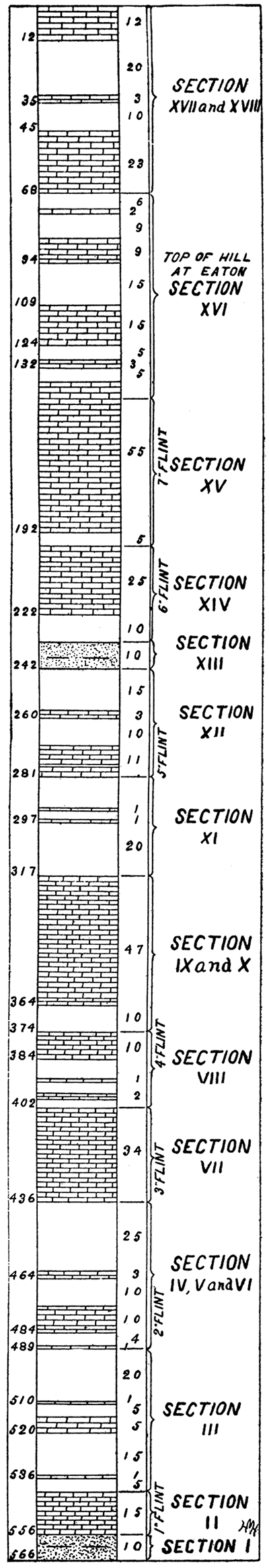
NOTE--The following section is to be accompanied by figure 1 and plate I. The section begins at the bottom of the column as exposed at Cedarvale and refers to the successive formations in ascending order until Winfield is reached.
SEC. I--Two layers each 5 feet thick of cross-bedded, fine-grained sandstone colored with iron. No fossils discovered.
SEC. II--Several massive beds of limestone 1 to 5 feet thick, not well exposed. Upper layers shaly and containing flint and chert. Fossiliferous. Many Fusilina cylindrica in flint.
SEC. III--Finely laminated shale shading from yellow to blue and green, probably glauconitic. Barren.
Massive limestone.
Finely laminated shale, arenaceous above. Barren.
Massive limestone very fossiliferous, corals, crinoid stems, Fusilina cylindrica.
Finely laminated shale; barren.
Massive limestone, very fossiliferous; crinoid, Spirifer sp., Fusilina cylindrica, Productus nebrascensis, and broken shells.
Twenty-five feet of yellow shale grading into spongy rotten limestone: barren. Dendritic markings and calcite crystals near the seams.
SEC. IV--Massive limestone 1 1/2 feet. Shale 1 foot. Limestone 1/2 foot, and shale 2 feet.
SEC. V--Three layers cherty limestone, very fossiliferous; calcite, Fusilina cylindrica, crinoid and a univale.
SEC. VI--Fine shale; barren.
Two layers (1 and 1-6) of massive limestone with a 6-inch layer of shale between.
Twenty-five feet of shale.
Five feet of massive limestone.
SEC. VII--Twenty feet of hackly limestone much broken in all directions, and cherty especially toward the top of the beds. Calcite crystals marked; very fossiliferous, Fusilina cylindrica.
Two layers of massive limestone.
SEC. VIII--Three feet of shale; 2 feet massive limestone; 4 feet of shale; 1 foot of massive limestone; 8 feet calcareous shale, Chenetes abundant; slightly cherty limestone.
SEC. IX--Ten feet of shale blue and yellow; 17 feet massive and shaly limestone, fossiliferous; 10 feet of shaly limestone.
SEC. X--Five feet layer of limestone with a layer of blue shale; 15 feet massive limestone with two layers of green glauconitic shale.
SEC. XI--Yellow to drab shale and shaly limestone, very fossiliferous, Productus nebrascensis, Myalina permiana, Myalina kansensis, Athyris subtilita, crinoid, Aviculopecten occidentalis, Pseudonumotis hawni, Lamellabranchs.
Two layers massive limestone, 1 foot. Red clay shales, barren, 4 feet. Massive limestone, 1 foot.
Red clay, barren, 4 feet.
Green and blue shale, 6 feet.
SEC. XII--Massive limestone. Green shale. Massive limestone with flint and fossils. Red clay shale, barren. Massive limestone. Clay shale, red.
SEC. XIII--Red sandstone No. 2 near top of hill at Hooser; sandstone much oxidized, cross-bedded; no fossils.
SEC. XIV--This section appears in part at the top of the hill at Hooser but is better studied west of Grouse creek, two miles northwest of Dexter, Kas., at a cut known locally as "The Sliding Bluffs."
Red and blue shale.
Rather shaly limestone; most fossiliferous stratum found: Derbya, Productus nebrascensis, and Productus semireticulatus, Pinna allarisma, Aviculopecten occidentalis, Myalina permiana, Myalina kansensis, crinoids; Athyris subtilita, lamellibranchs and univalve.
Six feet of massive limestone with flint nodules.
(a) Stratum with a very peculiar non-calcareous nodular concretion, brown; showing oval rings wherever broken.
Three feet of massive limestone With flint.
(b) Six-inch bed of calcareous nodular concretions much resembling those in (a) but calcareous and smaller.
Massive limestone; common fossils.
SEC. XV--Five feet red clay.
Rotten shaly limestone; fossiliferous.
Massive limestone.
Rotten limestone.
Massive light-gray limestone with flint nodules; upper flint beds.
SEC. XVI--Thin-bedded hard blue and gray limestone, very persistent; barren. The commercial building stone of Cowley county.
Gray shale. Massive limestone.
Shale at surface near Eaton, Kas.
The 14-foot layer at the bottom of section XVI can be traced across the country to Winfield. It supplies the building material for Winfield and is extensively quarried at different points in the county.
Thin-bedded blue and gray limestone exposed in bed of river below dam, same as exposed near Eaton. The building stone.
Unexposed.
Greenish yellow rotten limestone.
Very hard massive limestone.
Shale, greenish yellow oxidizing on exposure to air giving a red color to many slopes in vicinity.
Finely laminated massive limestone with many small nodules (1 to 1 inch) inclosing a crystal as fossil.
Greenish yellow shale, barren.
SEC. XVII--Rugged massive limestone, very persistent, forming cap of many hills and knobs east of the Walnut; not laminated but very fossiliferous: crinoid stems, Pinna aechaeacidale, Bryozoa, corals. So different from neighboring rock that I make it a section.
SEC. XVIII--Blue shaly limestone, fossiliferous; Productus, Athyris, Aviculopecten, etc.
Massive limestone; barren.
Fossiliferous shale and limestone.
Unexposed.
Massive limestone.
Unexposed.
Thin-bedded massive limestone quarried at Arkansas City.
Shale to top of hill.
Dakota sandstone.
Tertiary conglomerate.
Section XVIII was made on the east slope of the Walnut at Arkansas City. Some five miles northwest of the city I found several patches of dark-brown sandstone which Professor Hay takes to be Dakota. At the end of the Geuda Springs bridge, five miles northwest of Arkansas City, is a good exposure of Tertiary grit. West of the Arkansas are several exposures of black and blue shale along certain ravines, but I have never tried to estimate the thickness.
Plate I--A Geologic Section along the south side of the state from Galena to Winfield.
By Geo. I. Adams; to accompany Chapter I.
Scale: Vertical, 1 inch equals 500 feet; horizontal, 1 inch equals 5 miles.
The limestones are represented by the conventional masonry.
The shales and sandstones are left bare.
The surface contours are taken partly from railroad levels and partly from the United States Geological Survey Topographic sheets.
Available as an Acrobat PDF, 3 MB.
Plate IX--A Topographic Map showing the elevations in the Flint Hills area, copied from the United States Geological Survey Topographic sheets.
By Geo. I. Adams; to accompany Chapter I.
Contour interval 250 feet.
The streams and towns in adjoining territory are given to assist the reader in a proper orientation of the Flint Hills.
Available as an Acrobat PDF, 1.2 MB.
Prev Page--Introduction || Next Page--Chapter II
Kansas Geological Survey, Geology
Placed on web June 1, 2017; originally published 1896.
Comments to webadmin@kgs.ku.edu
The URL for this page is http://www.kgs.ku.edu/Publications/Bulletins/Vol1/chapt1.html