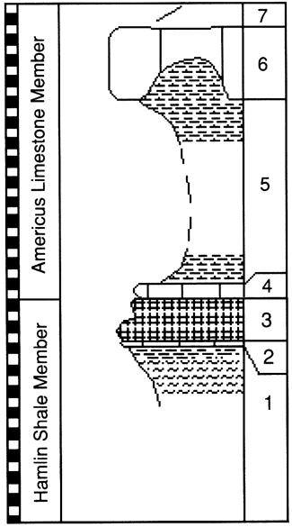
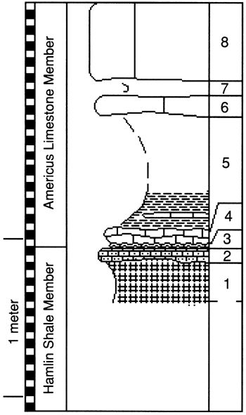
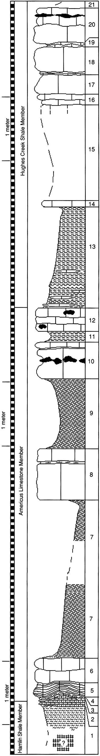
 |
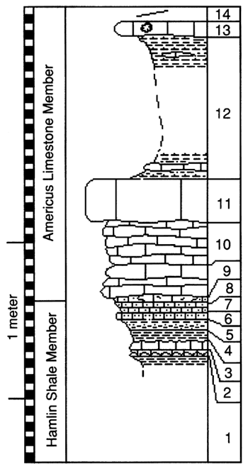
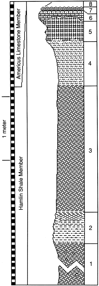
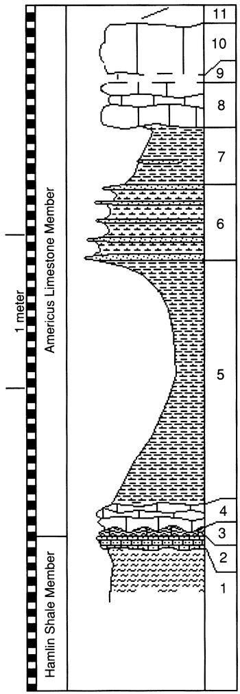
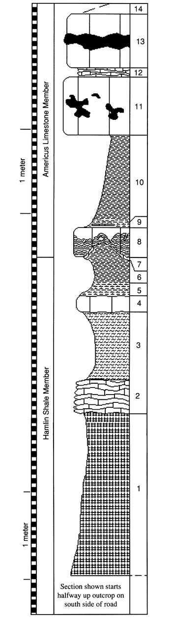
| Outcrop 23--SW sec. 1, T. 26 S., R. 8 E., Greenwood County. Outcrop is between old and new US-54, west of Reese, Kansas. |
Thickness |
| m |
ft |
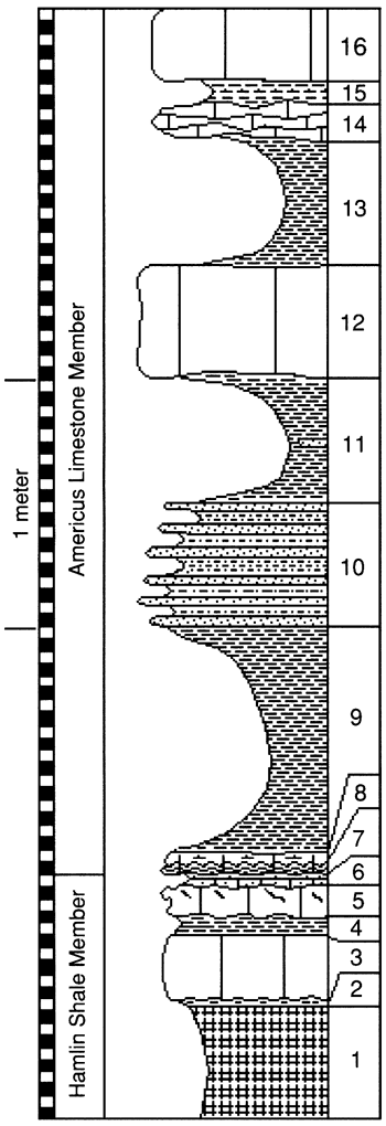
| 21. |
Covered |
| 20. |
Fusulinid wackestone, gray, cherty, with abundant fusulinids, few crinoids, rare solitary corals; lenticular chert layer near top |
0.56 |
1.8 |
| 19. |
Fusulinid mudstone, gray, platy |
0.06 |
0.2 |
| 18. |
Crinoid wackestone, dark-gray, rare fusulinids; crinoid diameter 1-5 mm |
0.39 |
1.3 |
| 17. |
Fusulinid-gastropod wackestone, gray; abundant bellerophontid gastropods near base |
0.3 |
1.0 |
| 16. |
Mudstone, gray, shaly, with abundant fusulinids and crinoids |
0.18 |
0.59 |
| 15. |
Covered interval with 0.03 in of fusulinid mudstone exposed near top |
1.5 |
4.9 |
| 14. |
Gastropod wackestone, yellowish-gray, with abundant bellerophontid gastropods |
0.11 |
0.36 |
| 13. |
Shale, yellow, calcareous, with lenses of brachiopod-crinoid wackestone, yellow, burrowed, with abundant Derbyia brachiopods and fenestrate bryozoans, few ostracodes, and rare mobile foraminifers |
1.6 |
5.2 |
| 12. |
Fusulinid wackestone, gray, cherty, with abundant fusulinids in upper part and abundant 1-mm-diameter crinoids |
0.36 |
1.2 |
| 11. |
Shale, yellow, calcareous, with abundant fusulinids |
0.18 |
0.59 |
| 10. |
Fusulinid-crinoid wackestone, gray, cherty, with bedded chert in middle of bed |
0.57 |
1.9 |
| 9. |
Shale, yellow and black, fissile |
1.1 |
3.6 |
| 8. |
Crinoid wackestone, gray, with abundant 1-mm-diameter crinoids and common 1-cm-diameter crinoids; calcareous shale parting occurs 0. 16 in from top |
0.8 |
2.6 |
| 7. |
Shale, yellow and gray |
2.54 |
8.33 |
| 6. |
Foraminifer wackestone to mudstone, whitish-gray, burrowed, with abundant Calcivertella foraminifers (8%), productid brachiopod fragments and spines, and ostracodes, many crinoid fragments and gastropods, and few Globivalvulina and Nodasaria foraminifers; tiny bivalve fragments abundant in upper 2 cm; gastropods and crinoids become rare toward base; burrows (4 mm in diameter) filled with foraminifer mudstone |
0.31 |
1.0 |
| 5. |
Peloid-quartz-silt mudstone to wackestone, light-gray, planar bedded, no fossils, ripple laminated; micritic peloids up to 30% of rock; wavy base; 5-mm-thick horizontal layers display fining-upward trend in peloid size from fine-grained sand to coarse-grained silt |
0.15-0.22 |
0.49-0.72 |
| 4. |
Peloid-quartz- silt mudstone and boundstone, light-brown; mudstone contains few ostracodes and tiny bivalve fragments and, toward top, abundant quartz silt; boundstone occurs as 21-cm-long, 10-cm-wide, 2-cm-thick plates with curled-under edges; plates contain 2-cm-wide hemispherical mounds with turned-down edges, suggestive of algal growth; tiny mound features are made of peloid mudstone and contain no laminations or other internal features (such as threadlike tubes or between-peloid spar) typically seen elsewhere in peloid-alga boundstone |
0.01-0.03 |
0.03-0.10 |
| 3. |
Peloid-quartz-silt wackestone, yellow to orange, with many tiny bivalve fragments and ostracodes, horizontal joint cracks |
0.02 |
0.07 |
| 2. |
Lime- sand-bivalve packstone to grainstone, orange, with coarse to fine sand sized lime grains (40%), tiny bivalve fragments, common ostracodes, few Gyrogonites, and rare fine quartz-sand grains; grains display PE1 crust; between-particle pore spaces filled with PE34 spar cement |
0.1 |
0.3 |
| 1. |
Mudstone, yellow to tan, terrigenous, blocky; lower part covered but float indicates boxwork terrigenous mudstone |
|
|
|