Kansas Geological Survey, OGI 11
Originally published in 1954 as Kansas Geological Survey Oil and Gas Investigations 11. This is, in general, the original text as published. The information has not been updated. An Acrobat PDF version (125.8 MB) is also available.
Structure maps of the Stone Corral and Dakota formations show regional dip toward the north but are discordant in many respects. The thickness map of the interval between them reveals the structure of the Stone Corral when the Dakota was still undisturbed. The difference between the structure of the Stone Corral and the Dakota is due to the fact that the structure of the Stone Corral was already well defined before the development of conflicting post-Dakota deformation. The Stone Corral-Dakota thickness map shows that at the end of Dakota time, the structure of the Stone Corral formation conformed to the pattern of deformation that produced the Hugoton embayment of the Anadarko basin. This thickness map also reveals that there was, at the end of Dakota time, a northerly trending anticline (Oakley anticline) with structural relief of more than 200 feet at the top of the Stone Corral. Arching of the Central Kansas uplift was inactive after Stone Corral time and probably for some time before, but secondary structures continued to develop on its crest even after Dakota time. Except as reflected by the western limb of the Hugoton embayment, the northeasterly dip on the flank of the Las Animas arch was accentuated in Kansas after Dakota time and was in the main a postCretaceous structural feature in Kansas.
Post-Dakota deformation resulted in a generally northerly dip of the rocks of the region and introduced new regional structural features. These movements reinforced some of the older regional features, modified all in varying degree, and destroyed some broad pre-Cretaceous structural features at the horizon of the Stone Corral. The Oakley anticline was cancelled out at this horizon by a post-Dakota syncline, and the steeper anticlinal structure of the Oakley anticline in older rocks was modified but not destroyed. In a large part of the area east of the Las Animas arch, the low post-Dakota northerly dip did not materially alter the relation of anticlines at the horizon of the Stone Corral to the steeper structures of the older rocks.
A thickness map and cross sections of the Morrison formation reveal topographic relief at its top and bottom and suggest a low dip toward the Denver basin at the close of Morrison deposition. A thickness map of the interval between the base of the Cretaceous and the top of the Dakota reveals pre-Cretaceous topographic relief of more than 400 feet. An east-west cross section shows the bifurcation of the Stone Corral in southwestern Kansas. A north-south cross section shows that post-Permian movements tilted the Stone Corral formation toward the north but failed to overcome the original southerly dip of deeper beds whose dip was reduced by the amount of the post-Dakota northerly dip.
The study of the late Permian and Cretaceous structural development of western Kansas began as a cooperative project between the Federal Geological Survey and the State Geological Survey of Kansas.
Structure maps of the Stone Corral and Dakota formations prepared as a part of this project by Batchelor (1952) revealed the conflicting character of the structure of these formations and indicated the desirability of further study to explain the conflicts, to add later data, and to exclude doubtful material. As a result, the structure maps have been redrawn and the report has been expanded to include additional structure maps, isopachous maps, and cross sections preliminary to a more extensive study of structural movements affecting the older rocks of western Kansas. This later work was done by the State Geological Survey. The maps and discussion are preliminary and are subject to revision with every new well drilled. Although there are few wells in some areas, the maps reveal the regional structural movements in most areas with considerable fidelity.
Most of the information used in preparing the maps was obtained from electric logs which were supported by the examination of samples from many wells. A few gamma ray logs were used. Where electric and gamma ray logs were not available, plotted logs of the Kansas Sample Log Service and ground-water test well logs were used. Drillers logs and scout tops were used to a limited extent. The maps contain all the information available to the State Geological Survey of Kansas on September 1, 1953.
Maps were prepared to show the structure of (1) the top of the Stone Corral formation (Pl. 1), (2) the top of the Dakota formation (Pl. 2A), (3) the top of the Graneros shale, (4) the top of the Carlile shale (base of the Niobrara formation) (Pl. 2B), and (5) the top of the Niobrara formation (Fig. 6). The structure of the top of the Graneros shale (25 to 55 feet above the Dakota) closely parallels the structure of the top of the Dakota formation and is not reproduced. Each structure map shows the present surface outcrop of the corresponding formation and indicates the limit of control.
In areas where there is an abundance of information as in Russell, Rooks, and Ellis Counties (on the Central Kansas uplift) and in Grant, Haskell, and Kearny Counties (in the Hugoton gas field), a contour interval of 25 feet has been used. In areas where few wells have been drilled, 50-foot contours represent regional structure only.
Isopachous maps were prepared showing the thickness (1) between the top of the Stone Corral formation and the top of the Dakota formation (Pl. 3A), (2) between the top of the Dakota formation and the top of the Carlile shale (Pl. 3B, (3) of the Niobrara formation (Fig. 11), (4) of the Morrison formation (Fig. 8), and (5) between the base of the Cretaceous and the top of the Dakota (Fig. 10).
Previous work
Probably the first map showing the regional structure of the Dakota formation in western Kansas and adjoining areas was prepared by Darton (1905). A more detailed map by Darton covering approximately the same area was issued in 1918. In 1926 Bass published a structure map of the Dakota formation in western Kansas. Reports by Rubey and Bass (1925), Wing (1930), Landes and Ockerman (1930), and Elias (1931) included maps showing the structure of the Dakota in several Kansas counties. Work on the structure of the Great Plains has been done in adjoining states by Fuenning (1942), McCoy (1953), and Maher (1953) who also studied the Paleozoic rocks of western Kansas. Lee (1953) briefly reviewed the geologic history of the area in a cross section from Smith to Meade County across the Central Kansas uplift. The additional data made available by the greatly increased number of wells drilled in western Kansas now make it possible to show the structure in greater detail. Data from future wells undoubtedly will modify the contours and add to their accuracy.
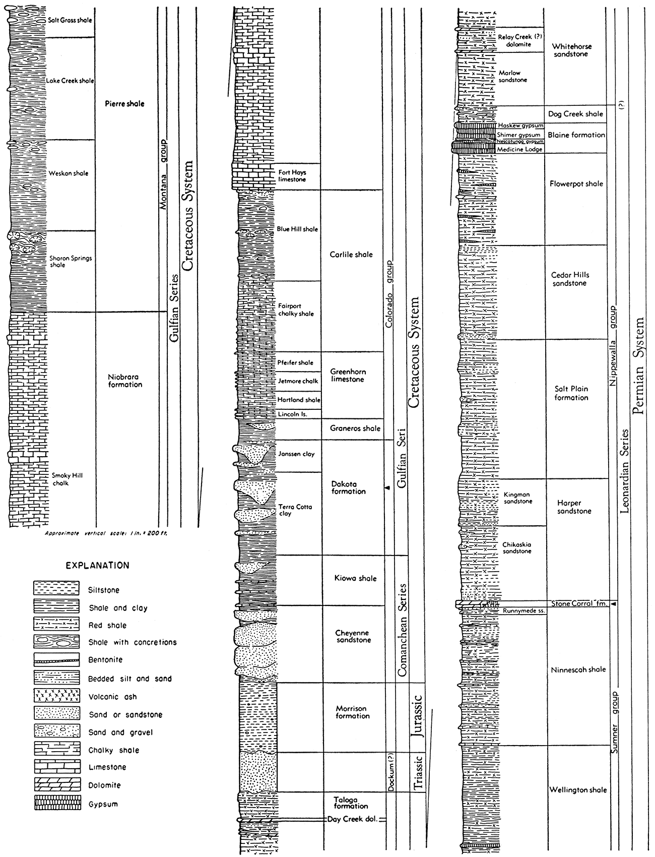
This study of western Kansas relates primarily to the regional structural development and only the formations involved in the discussion are described. They range in age from the Stone Corral formation of the Permian System to the Pierre shale of the upper part of the Cretaceous System. The study was not concerned with the detailed stratigraphy of the intervening formations. The following descriptions are derived in part from a bulletin by Moore and others (1951). Figure 1 shows in outline the relative positions of the formations mentioned in this report.
Figure 1—Graphic columnar section showing relative stratigraphic positions of the formations mentioned in this report (Moore and others, 1952).
Stone Corral formation
The Stone Corral formation is the uppermost formation of the Sumner group of Leonardian (middle Permian) age. It consists of dolomite, anhydrite, and shale. In outcrops, the anhydrite has been leached by surface waters and the formation consists mainly of dolomite. At the surface it is known as the Stone Corral dolomite but in the subsurface where anhydrite predominates it is generally referred to as the Stone Corral or Cimarron anhydrite. In the subsurface, this sequence is represented by a white and mottled gray crystalline anhydrite interbedded with red silty shale. Locally the anhydrite is dolomitic, commonly near the base of the formation. Some wells include finely crystalline anhydrite of sugary texture. On account of its composite character in the subsurface, it is herein referred to as the Stone Corral formation.
The thickness of the Stone Corral formation in the subsurface is generally between 25 and 45 feet. In southwestern Kansas, however, in Gray, Finney, Kearny, and Grant Counties, the formation is 90 to 100 feet thick, and consists of two anhydrite beds separated by red shale. The lower anhydrite bed is more restricted in areal extent than the upper. Its approximate limit is shown in Figure 2. The upper bed can be traced into Colorado where Maher (1953, p. 921) has correlated it with the "contact limestone" at the top of the Fountain formation in the Front Range of Colorado. In some areas, electric logs show a peak a short distance above the Stone Corral which examination of samples reveals as representing gypsiferous red shale and not the top of the Stone Corral.
The formation is underlain and overlain by beds of red silty shale and shaly sandstone. Because of this contrast in lithology the Stone Corral formation is an excellent marker in well samples and in electric and gamma ray logs. Inasmuch as it is the only good and persistent marker in the redbed section of western Kansas, the Stone Corral is often used as a reference horizon in structural mapping. The Blaine formation, higher in the Permian, is less wide spread. Other anhydrite beds of local distribution higher in the section have been confused with the Stone Corral formation in the logs of some wells.
Permian beds above the Stone Corral formation
The Permian section above the Stone Corral formation is divided into several formations. For the most part these beds consist of red shale, sandstone, gypsum, and anhydrite. The interval from the Stone Corral formation to the top of the Permian ranges from less than 300 feet in the north to more than 1,200 feet in the south, due to the truncation by erosion of the southerly dipping Permian rocks before the overlying Cretaceous rocks were deposited.
Figure 2—Cross section showing separation of Stone Corral formation into two anhydrite member on line A-A' and inset outlining area in which separation occurs. [A larger Acrobat PDF version is available (4.8 MB).]
In Morton County in extreme southwestern Kansas outcrops of sandstone as much as 40 feet thick have been correlated tentatively with the Triassic Dockum group of Texas (Moore and others, 1951, p. 29). They are unconformable on Permian rocks and are overlain unconformably by Tertiary rocks. The Triassic has not been recognized in other parts of Kansas.
Morrison formation
The Morrison formation of Jurassic age occurs only in the subsurface in the northwestern corner of Kansas. It consists of varicolored shale with some limestone, anhydrite, and chert. The shales are usually calcareous and sandy. A persistent zone of cherty shale occurs near the middle of the formation. The chert is white or pinkish and is translucent. Limestone occurs in the extreme northwestern part of the Kansas area. White to pinkish crystalline anhydrite is common near the base. The formation in Kansas ranges in thickness from a featheredge to 350 feet.
The Cretaceous deposits in Kansas have been divided into the Comanchean (lower) and Gulfian (upper) Series. The Comanchean consists of the Cheyenne sandstone and the Kiowa shale. The Dakota formation and younger Cretaceous rocks are of Gulfian age.
Cheyenne sandstone
The Cheyenne sandstone, which is nonmarine, is varicolored, fineto coarse-grained, cross-bedded, and contains some shale. Locally a conglomerate is developed at the base of the Cretaceous sediments with cobbles of quartzite, chert, and limestone as much as 3 inches in diameter (Plummer and Romary, 1947, p. 320). At the type locality the Cheyenne is 40 feet thick but it is reported to have a thickness of at least 300 feet in some places in the subsurface. The Cheyenne is overlain by the marine Kiowa shale.
Kiowa shale
The Kiowa shale is light to dark gray, fissile, and silty with minor sandstone and limestone beds. The formation ranges in thickness from 60 to 115 feet.
Dakota formation
The Dakota formation is nonmarine; it consists mainly of clay and sandstone. Approximately three-fourths of the Dakota formation is made up of clay at the outcrops (Plummer and Romary, 1947, p. 41). Minor constituents such as shale and lignite occur locally. Siderite, pyrite, limonite, and other iron minerals are present in varying amounts throughout the formation.
Most of the clay is carried away in drilling, leaving abnormally high proportions of sand or siderite pellets in many samples from the subsurface. The sandstones are white to gray to reddish in color, in part pyritic, and ferruginous. The sand grains are fine to medium and angular to rounded. Calcareous siltstones are present locally but are uncommon. Siderite pellets occur throughout most of the formation. Some of the siltstones and sandstones contain glauconite.
The top of the Dakota formation is obscure in some electric logs and in some sample logs because the sandstone usually present at its contact with the overlying Graneros shale is missing. However, thickness variations of the Graneros shale are gradual and, in the absence of the sand, the top of the Dakota can be determined within 5 or 10 feet by measuring down from the top of the Graneros, using thickness data from surrounding wells. The formation ranges in thickness from 100 to 300 feet.
Graneros shale
The Graneros shale, which is marine, closely resembles the Kiowa shale. The Graneros is gray to dark gray, fissile, pyritic, and silty shale that locally includes minor amounts of gypsum, siderite, and limestone. It is overlain by the Greenhorn limestone. The Graneros-Greenhorn contact is difficult to determine from well samples on account of its transitional character but is clearly distinguishable on electric logs. The Graneros shale ranges in thickness from 25 to 55 feet.
Greenhorn limestone
The Greenhorn limestone, next above the Graneros, consists mainly of chalky limestone and shale ranging in color from white to medium gray. The Fencepost limestone bed, which occurs near the top of the formation, consists of a firm chalky slightly crystalline limestone which gives one of the most characteristic peaks on electric logs in the whole section. Its representation on electric logs is so distinctive that it can be recognized in Colorado, Nebraska, and Wyoming. The Greenhorn limestone is marine and ranges in thickness from 90 to 130 feet.
Carlile shale
The Carlile shale, which conformably overlies the Greenhorn limestone, is divided into two members, the Fairport chalky shale below and the Blue Hill shale above. The Fairport member is a dark-gray; mottled, calcareous shale with thin limestone stringers. The Blue Hill shale member is medium to dark gray, noncalcareous, slightly micaceous, and pyritic. At the outcrops, the Blue Hill contains large septarian concretions. The Codell sandstone zone, at the top of the Blue Hill shale member, is persistent over a wide area. It is gray to brown, fine-grained, silty, and calcareous, and ranges in thickness from a featheredge to about 25 feet. The Carlile shale is usually about 300 feet thick and is overlain by the Niobrara formation.
Niobrara formation
The Niobrara formation is divided into two members: the Fort Hays limestone below and the Smoky Hill chalk above. The Fort Hays is composed of white to light-gray chalky limestone. The Smoky Hill is composed of light- to dark-gray soft chalky limestone and chalky shale. The thickness of the Niobrara ranges from 550 to 800 feet.
Pierre shale
The Pierre shale, above the Niobrara formation, is light to medium gray, soft, micaceous, and calcareous, with occasional rounded nodular concretions in outcrops. It occurs only in the northwestern corner of the State where it attains a maximum thickness of 1,400 feet.
Cretaceous rocks are overlain unconformably by Tertiary or Quaternary rocks, for the most part consisting of unconsolidated coarse calcareous sandy beds and conglomerate.
The structure maps of the Stone Corral and other formations are based mainly on electric logs but some data from other sources have been utilized. The accuracy of the contours is subject to the abundance of data in circumscribed areas. In some of the older closely drilled producing areas the structural features at the horizon of the Stone Corral and Dakota formations cannot be determined because the data were not recorded. The reliability of the contours is also dependent on the accuracy of the surface elevations which have been obtained from various sources and cannot be checked. In some places errors of elevation of as little as 5 or 10 feet may result in misleading inaccuracies in the configuration of the contours. The contours have been freely drawn and in the absence of local data, structural features that are clearly defined in some areas have been extrapolated into areas of little or no control. The contours as drawn in such areas are therefore speculative and subject to revision on the acquisition of additional data. It must also be pointed out that the maps were prepared primarily for the study of regional structure without intention to show the detailed relation of local structure to oil-producing areas. Many such areas occur on anticlines and structural noses of the Stone Corral but are not everywhere accurately centered on the structure as depicted. In some areas this may be due to shifting of the crest in the deeper rocks; in others, to accumulation in stratigraphic traps; and in part to generalization in drawing the contours from limited data. Some of the smaller pools which occur in areas in which there seems to be no local structure may be attributed either to accumulation in stratigraphic traps or to the absence of local detail for contouring.
The present structure of the Stone Corral formation (Pl. 1) is the result of all movements that modified its originally flat surface. These movements include those that occurred during the remainder of the Permian, during Triassic and Jurassic time, and during and after Cretaceous time. The structure of the Stone Corral does not everywhere reflect the regional structure of the older rocks with complete accuracy as will be shown later.
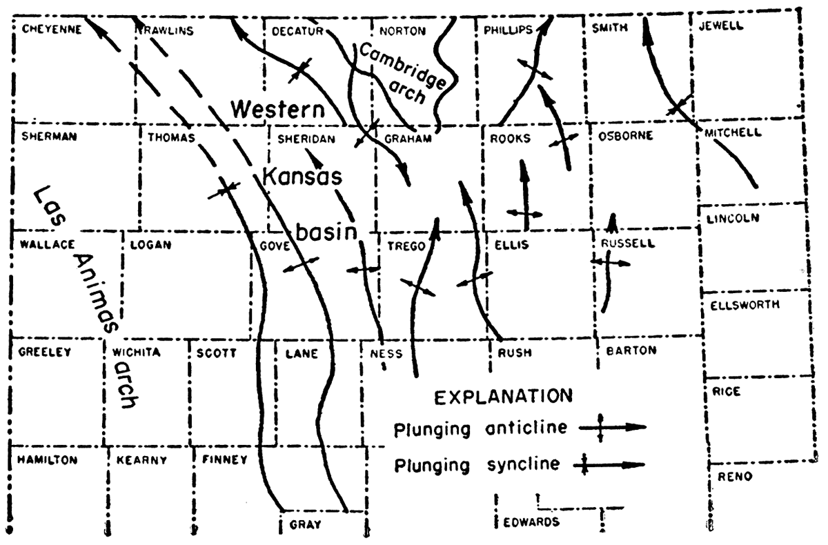
The Stone Corral structure reveals the present form of the principal structural features of the region such as the Cambridge arch, the Las Animas arch, and the intervening Western Kansas basin, a later modification of the Hugoton embayment. The average northerly dip in the central part of the area is about 5 feet per mile.
Central Kansas uplift
The Central Kansas uplift is represented only as a broad northwesterly sloping surface flanked on the northeast and southwest by secondary synclines. The surface displays no regional arching but many minor northerly to northwesterly plunging anticlines and synclines occur in the area. Northerly trending folds are represented by the Fairport anticline in Russell County and the Stuttgart-Huffstutter anticline in Phillips County. Northwesterly folds are exemplified by the Wakeeney anticline in Trego County. Twenty-five foot contours in closely drilled areas show some closed anticlinal and synclinal structures. Future drilling and more detailed mapping will probably reveal other closures in areas shown on the map as gently plunging noses.
A broad syncline, based on the evidence of only a few wells, seems to border the northeastern margin of the Central Kansas uplift in Osborne, Smith, and eastern Phillips Counties. The syncline trends and plunges northwest, turning north on the east flank of the Stuttgart-Huffstutter anticline as shown on Figure 3. It lies at the north end of what was formerly the Salina basin with which it is aligned. It is, however, a post-Permian or post-Cretaceous structural feature and if it represents a revival of the Salina basin, the area affected is small.
Figure 3—Guide map showing the principal structural elements of the top of the Stone Corral formation as shown on Plate I.
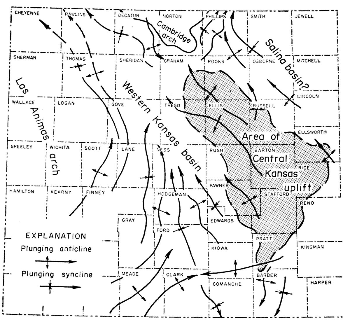
Cambridge arch
The Cambridge arch of Nebraska lies on the same general trend as the Central Kansas uplift. Its southeastern end is represented in Decatur and Norton Counties as a southerly plunging arch. It is separated from the area of the Central Kansas uplift by a saddle in which there are several closed synclinal basins. The secondary folds that occur on this part of the Cambridge arch resemble the northwesterly trending folds in the area of the Central Kansas uplift except that they plunge to the southeast. The western flank of the Cambridge arch is relatively steeper than the eastern flank.
Las Animas arch
The northeastern flank of the Las Animas arch is shown in southwestern Kansas by an average northeasterly dip of 16 feet per mile. On the southern Kansas border, from the southwest corner of the State east to central Meade County, a distance of 95 miles, the east component of the dip lowers the Stone Corral 1,200 feet. On the western Kansas border from the southwest corner of the State to northwestern Cheyenne County, a distance of 197 miles, the north component of the dip lowers the Stone Corral 2,350 feet.
Northeasterly plunging anticlines and synclines occur on the Stone Corral on the flank of the Las Animas arch in Kansas. Closed anticlines in Kearny County are revealed by 25-foot contours. Other closed anticlines will probably be revealed by more detailed contouring of structural noses and by future drilling in areas where control is limited at present.
Western Kansas basin
The Western Kansas basin, which lies between the Las Animas arch and the area of the Central Kansas uplift, is more or less in the position of the former Hugoton embayment. At the horizon of the Stone Corral the basin is limited on the south by a broad westerly trending arch in southern Kiowa County and northern Clark County which turns south in eastern Meade County. Like the Hugoton embayment the Western Kansas basin is a broad syncline, but unlike the earlier basin it plunges toward the north instead of toward the south at the horizon of the Stone Corral. It is bordered on the east by the northwesterly sloping surface of the former Central Kansas uplift, with which it is roughly parallel, and on the west by the northeastern flank of the Las Animas arch. The basin is roughly 100 miles wide and 200 miles long and extends an undetermined distance into Nebraska.
There are many secondary elements of folding in the basin, all of which plunge in a northerly direction at the horizon of the Stone Corral. The structures on the eastern side of the basin are roughly parallel to the Central Kansas uplift but those originating on the flank of the Las Animas arch trend northeast, then north, before paralleling the Central Kansas uplift or the Cambridge arch.
One of the more conspicuous of these anticlines, as shown on Figure 3, is nearly 200 miles long. It originates in northern Finney County as a northeasterly trending fold, swings north through Lane and Gove Counties, thence northwest, paralleling the southern end of the Cambridge arch. The trend of this anticline in Thomas and Rawlins Counties is obscure for lack of data and has been sketched in without adequate control. A syncline parallels this anticline on the west. It is well defined in Scott and Logan Counties but there is not enough control to substantiate its continuation into Thomas and Rawlins Counties as suggested on the map. A similar anticline parallel to the previously mentioned anticline originates in northern Seward County with a northeasterly trend, turns north through Hodgeman County, and dies out with a northwesterly trend in northwestern Ness County. The positions of other prominent anticlines and synclines are indicated on Figure 3.
In the absence of more complete control, it is quite possible that these long linear anticlines are actually interrupted, discontinuous, or en echelon folds.
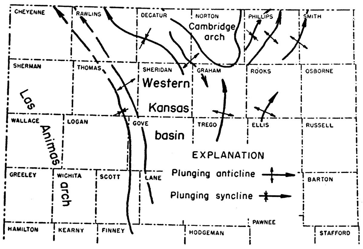
There is considerably less data for determining the structure of the Dakota than for the Stone Corral because data above the Stone Corral from many of the wells that have been drilled are not available. The mappable area of Dakota structure is limited south of Hamilton, Finney, and Rush Counties and in counties farther northeast by the removal of the Dakota by post-Dakota erosion.
The structure of the Dakota (Pl. 2A) is somewhat similar to that of the Stone Corral but there are many differences. The map reveals only the post-Dakota structural movements and does not include deformation that occurred during late Permian time, during the Triassic, Jurassic, or Cretaceous prior to the deposition of the Dakota. The average northerly dip in the central part of the area is about 7 feet per mile.
Central Kansas uplift
By the end of Dakota time the area of the former Central Kansas uplift had become a northerly sloping surface scored by northerly and northwesterly plunging local anticlines as shown in Figure 4. The northerly slope of the surface is in contrast with the northwesterly slope of the Stone Corral. The southwestern flank of the area is unmarked by limiting structural features. The area is set off on the northeast somewhat vaguely by a broad northerly plunging synclinal area suggested by the limited data at the northern end of the former Salina basin. This synclinal basin is even less pronounced than a similar structure on the Stone Corral map (Pl. 1), possibly because fewer wells in this locality have recorded the top of the Dakota.
Figure 4—Guide map showing the principal structural elements of the top of the Dakota formation as shown on Plate 2A.
Cambridge arch
The expression of the southeastern end of the Cambridge arch on Figure 4 closely repeats the structure of this feature as shown on the Stone Corral map. It has a similar crenulated pattern of southeasterly plunging folds and is separated from the area of the former Central Kansas uplift by a number of synclinal basins.
Las Animas arch
Inasmuch as the Dakota has been eroded from the southwestern corner of Kansas, the expression of the Las Animas arch on the Dakota map (Fig. 4) is confined to the northwest. The surface of the Dakota on the Las Animas arch displays an average northeasterly dip of 20 feet per mile from Hamilton County to northeastern Gove County. Along the western border of the State, from the center of the western half of Hamilton County to the northwest corner of Cheyenne County the north component of the dip lowers the surface of the Dakota 2,150 feet in 132 miles. Between the same points, the surface of the Stone Corral (as shown on Plate 1) is lowered only 1,600 feet. The north component of dip of the Stone Corral is thus less than the corresponding dip of the Dakota between the same points. This anomaly, as will be explained later in detail, is due to the fact that at the end of Dakota time, when the surface of the Dakota was flat, the Stone Corral dipped toward the south.
The northeasterly slope of the Dakota on the flank of the Las Animas arch is terminated by a well-developed syncline that follows the margin of the arch and will be referred to as the marginal syncline. The syncline trends north from central Finney County to Thomas County but its extension into Cheyenne County to the northwest is without adequate control. The marginal syncline conforms, in part, to a similar syncline on the Stone Corral map in Logan and parts of adjoining counties but its expression on that map is modified by pre-existing structure of the Stone Corral. South of Thomas County the marginal syncline intercepts and crosses an anticline of the Stone Corral map in Scott County and differs from the Stone Corral structure as far south as Finney County.
Western Kansas basin
The Western Kansas basin is a minor feature of Dakota structure. In Decatur County the relatively steep western limb of the Cambridge arch borders a small synclinal area that may be considered a survival of the Western Kansas basin. East of the Las Animas arch the Dakota surface dips regularly north in a series of northerly plunging anticlines and synclines that extend across the area of the former Central Kansas uplift.
The most prominent of the anticlines shown by the structure contours of the Dakota parallels the marginal syncline of the Las Animas arch from Finney County to Rawlins County. North of Gove County, in so far as data are available, this anticline seems to conform closely to a similar anticline on the Stone Corral. In the absence of contrary data it is tentatively extrapolated across Rawlins County. South of Gove County, this anticline, like the marginal syncline, bears no relation to the structure of the Stone Corral and trends indifferently across the anticlines and synclines of the Stone Corral map. Other less sharply defined features of the Stone Corral structure which lie east of this anticline are represented on the Dakota map in altered configuration or are without representation on the Dakota map.
Although the control is limited, the map of the top of the Carlile shale (Pl. 2B) shows structural features similar to those of the top of the Dakota formation. However, owing to the small areal extent of the formation, the only major structural elements that can be recognized are the Cambridge arch, part of the Western Kansas basin, and the Las Animas arch. The minor structural elements shown in Figure 5 resemble those of the Dakota. The dominant structural feature is the long linear northerly plunging marginal syncline on the eastern border of the Las Animas arch and a parallel anticline to the east. The low regional dip of the Carlile shale is to the north.
Figure 5—Guide map showing the principal structural elements of the top of the Carlile shale as shown on Plate 2B.
Because of limited control, the map showing the structure of the Niobrara formation (Fig. 6) covers only a small area. The structure of the Niobrara resembles the structure of the Carlile shale and the Dakota formation. The only recognizable structural features are the syncline in south-centrai Decatur County on the west flank of the Cambridge arch and the marginal syncline and its accompanying anticline on the eastern border of the Las Animas arch. The low regional dip is to the north.
Figure 6—Map showing by 50-foot contours the approximate structure of the top of the Niobrara formation based on widely separated wells, and inset indicating the axes of principal folds.
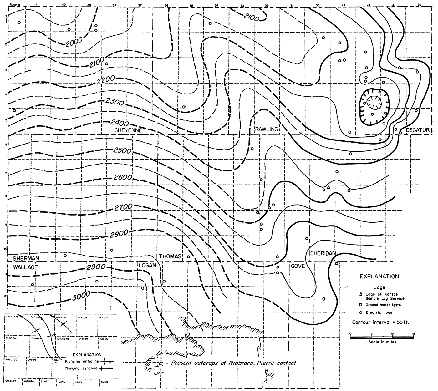
An isopachous or thickness map shows in three dimensions the thickness of rocks between any two horizons. If both surfaces were originally essentially flat, an isopachous map reveals the total structural movement of the lower surface when the upper surface was still undisturbed. If one of the surfaces displays topographic relief and the deformation between the development of the two surfaces was low, the thickness map will show roughly the topography of the eroded surface.
Inasmuch as the Stone Corral is an evaporite and the Dakota is overlain by the Graneros shale which has a variation in thickness of no more than 30 feet in 200 miles, the upper surfaces of both Stone Corral and Dakota must originally have been essentially flat. The thickness of the interval between them therefore reveals the structure of the Stone Corral when the surface of the Dakota was still undisturbed. The data for depicting the thickness of the interval between these two surfaces are even more limited than for the structure map of the Dakota and only regional structural features (shown by 50-foot contours) can be determined.
The structure of the Stone Corral revealed by the isopachous map (Pl. 3A) is the result of the warping of its surface during subsequent Permian time, during Triassic and Jurassic time, and during Cretaceous time to the end of Dakota deposition. It is therefore a composite of all movements that occurred between the deposition of the Stone Corral and the Dakota.
In so far as revealed by 50-foot isopachs, the map shows that there was no arching of the Central Kansas uplift as a major structural feature during this time but only tilting of the area toward the southwest (toward the Hugoton embayment). Upward movement of the southeastern end of the Cambridge arch is suggested by a bulge in the 1,050-foot isopach in Norton County.
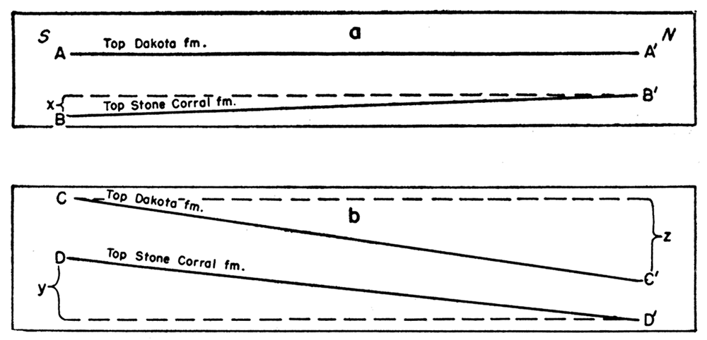
There is no indication of uplift of the Las Animas arch within the area of the map except in so far as it may be represented by the west limb of the Hugoton embayment. The southerly dip of the Stone Corral on the western border of the State at the end of Dakota time had lowered its surface toward the south in Hamilton County 550 feet below its level in Cheyenne County. As a result of post-Dakota movements the present component of dip between the same points as shown on the Stone Corral structure map (Pl. 1) is 1,600 feet toward the north. The present component of dip between the same points shown on the Dakota structure map (Pl. 2A) is 2,150 feet. The pre-Dakota southerly dip of the Stone Corral added to the present reverse dip toward the north exactly equals the present northerly dip of the Dakota between the same points as shown diagrammatically in Figure 7. The somewhat anomalous dip in the younger formations greater than in the older is due to the pre-Dakota initial southerly dip of the Stone Corral in opposition to post-Dakota reversal. The relations indicate that in Kansas the uplift on the northeastern flank of the Las Animas arch was imposed upon the Stone Corral after Permian time.
Figure 7—Diagram showing (a) the component of southerly dip of the Stone Corral formation on the western border of Kansas at the end of Dakota time, and (b) the reversal to a northerly component of dip induced by post-Dakota structure. x represents a southerly dip of 550 feet of the Stone Corral between points in Cheyenne and Hamilton County. y represents a northerly dip of 1,600 feet of the Stone Corral between the same points brought about by the post-Dakota northerly dip z of 2,150 feet.
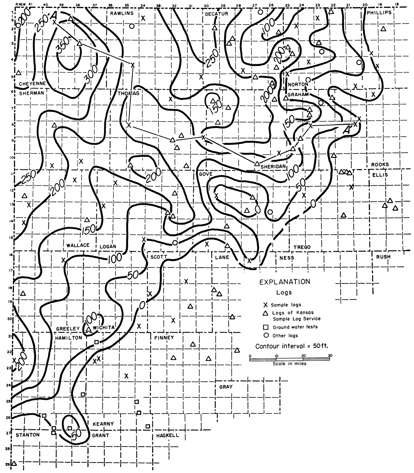
Synclinal movement in the general pattern of the Hugoton embayment is shown by the isopachs. The most striking and unexpected structural feature represented is a pre-Dakota southerly plunging anticline extending south from Thomas to Finney County. This anticline, which had a structural relief on the Stone Corral of more than 200 feet in Dakota time, will be called the Oakley anticline. It is flanked by structural basins; that on the west, in Kearny and Wichita Counties, will be called the Syracuse basin and that on the east, in Lane and Finney Counties, the Cimarron basin.
The western limit of the Hutchinson salt member of the Wellington formation as shown by Jewett and Schoewe (1942) borders the Oakley anticline on the east. The fact that this salt member was deposited before the Stone Corral and extends to the flank of the Oakley anticline but does not cross its crest implies that the Oakley anticline was active in Wellington time before the deposition of the Stone Corral.
The northern end of the post-Stone Corral salt beds of the Nippewalla group (as shown by Jewett and Schoewe, 1942) seems to have been similarly confined by the west flank of the rising Oakley anticline although farther south the salt beds are shown crossing the projected axis of the fold.
It is probable that many secondary structures were developing during this period but only a few are clearly revealed by available data. Local thinning of the sequence on the Stuttgart-Huffstutter anticline in T. 2 S. R. 19 W., and on the Sunny Slope anticline in T. 14 S., R. 21 W., indicates their pre-Cretaceous or strictly speaking pre-Dakota origin. More detailed contouring of the thickness will probably reveal other areas of pre-Cretaceous structure.
Figure 8 shows by 50-foot isopachs the thickness of the Morrison formation in northwestern Kansas. The Morrison forms a wedge thickening irregularly toward the northwest to more than 350 feet. In the absence of the Triassic rocks in this area it is clear that a hiatus exists at the base of the Morrison. Its upper surface was truncated with considerable topographic relief by pre-Cretaceous erosion. The northwestern thickening of the Morrison in the Kansas area is in accord with the distribution and thickness of the Morrison and other Jurassic formations in Colorado and Wyoming as shown by McCoy (1953).
Figure 8—Isopachous map showing by 50-foot thickness lines the generalized thickness of the Morrison formation in northwestern Kansas.
On the assumption that the top of the persistent cherty zone of the Morrison was originally a level surface, the few wells for which samples were available for study have been correlated on the top of the cherty zone as shown in Figure 9b. The wells of the cross section indicate topographic relief at the base of the Morrison of at least 110 feet, although greater relief may be shown by future drilling.
Using the same wells, Figure 9a shows the relation of the Morrison formation to the top of the Dakota at the end of Dakota time. The cross section indicates that by the end of Dakota time the surface of the chert zone of the Morrison on the line of the cross section had been tilted northwest 400 feet in 142 miles or an average of about 2 feet per mile.
Figure 9—Cross sections on the line A'-A' of Figure 8. The wells shown in cross section a are correlated on the top of the Dakota formation and reveal a low irregular northwesterly dip of the top of the Morrison cherty zone at the end of Dakota time. The same wells are correlated in cross section b on the top of the cherty zone of the Morrison and reveal the approximate topographic relief of the pre-Jurassic surface on the line of the cross section.
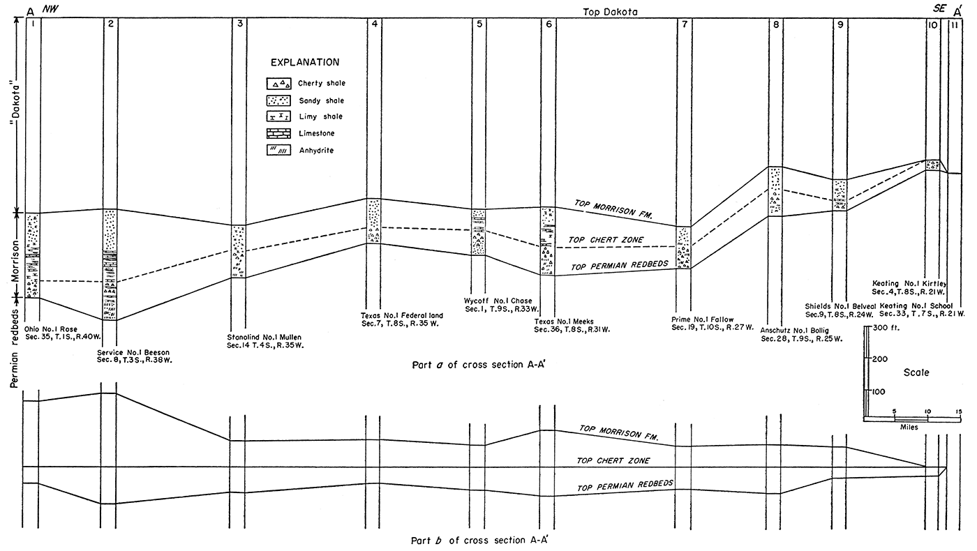
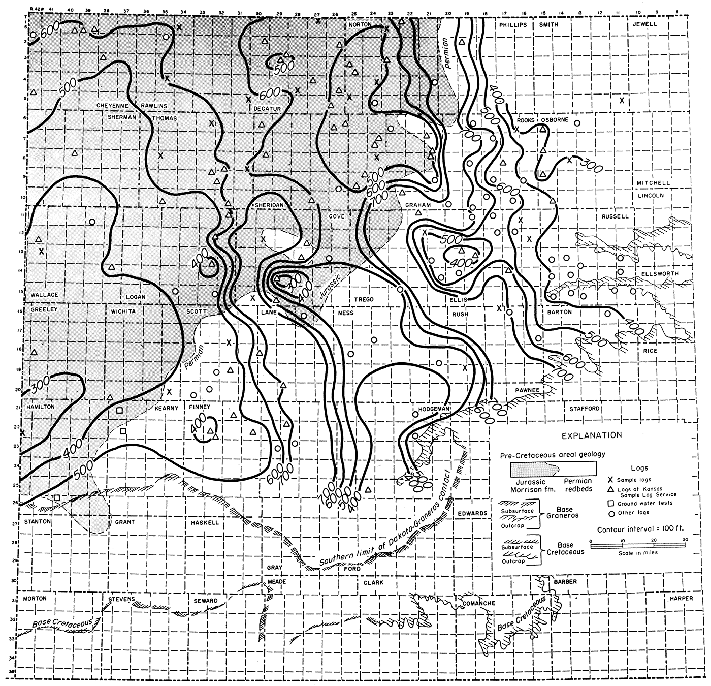
Figure 10 shows the thickness of the interval between the base of the Cretaceous and the top of the Dakota by 100-foot isopachs. In view of the relatively slow deformation of the Cretaceous sequence immediately above the Dakota as shown in Plate 3B, it seems probable that not much structural movement occurred during earlier Cretaceous time. This thickness map is therefore an approximation of the pre-Cretaceous topography. Broad open valleys trend south between irregularly shaped hills rising 400 to 500 feet above the main drainage lines.
Figure 10—Isopachous map showing by 100-foot contours the thickness of the interval between the top of the Dakota formation and the base of the Cretaceous rocks. The map reveals the approximate configuration of the pre-Cretaceous surface at the end of Dakota time and the areal limits of the Morrison formation.
In order to show the initial structural movement of post-Dakota time, a thickness map with 25-foot isopachs (Pl. 3B) was prepared for the interval between the top of the Dakota and the top of the Carlile shale (base of Niobrara formation), both believed to have been originally essentially flat surfaces. The thickness map displays no strong structural trends. It shows an overall southerly dip of the Dakota of about 75 feet suggesting that southerly tilting, although slackening, was still active. Warping of the Cambridge arch is suggested by the configuration of the 375-foot isopach.
At the western boundary of Kansas, the limited data suggest that the surface of the Dakota in reference to the top of the Carlile rose gently toward the south to a low crest in northern Wallace and northwestern Logan Counties. A poorly defined broad low syncline in southern Wallace and Greeley Counties interrupts the southern rise which otherwise might be regarded as movement of the Las Animas arch in Kansas. The post-Dakota marginal syncline, represented on this map, adds to the possibility that movement of the Las Animas arch occurred before the end of Carlile time. The Syracuse and Cimarron basins seem to have become mildly anticlinal under the influence of the marginal syncline but the control is poor. The anticlinal area in Lane County conforms vaguely to the present anticlinal structure of the Dakota.
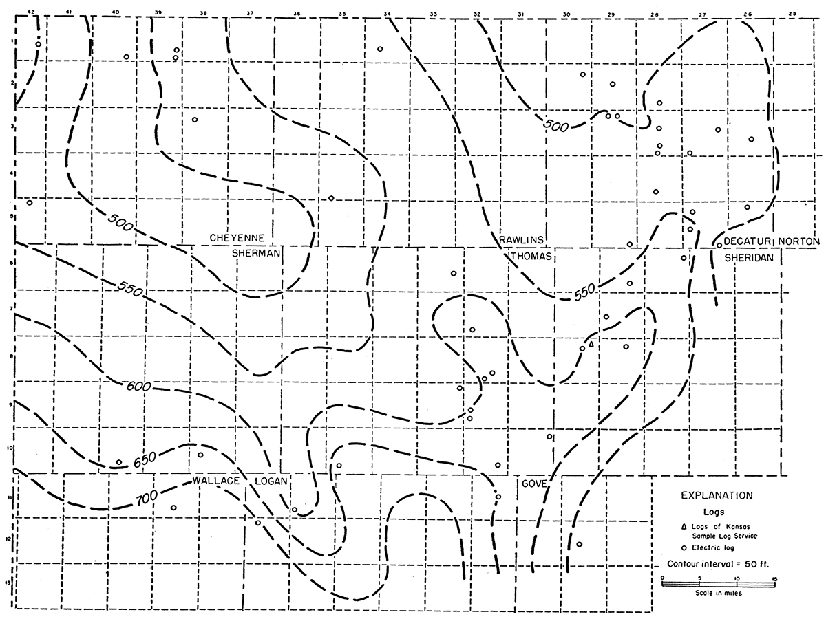
Isopachs showing thickness of the Niobrara limestone (top of Carlile shale to base of Pierre shale) (Fig. 11) can be drawn only within a small area in northwestern Kansas and their value in determining low structural warping is impaired by the possibility of topographic relief on the upper surface of the Niobrara as well as by limited control. The 50-foot thickness lines reveal little except low southerly dip.
Figure 11—Isopachous map showing by 50-foot contours the thickness of the interval from the top of the Carlile shale to the top of the Niobrara formation (thickness of Niobrara formation). This map, which represents the attitude of the top of the Carlile shale at the end of Niobrara time, reveals a low overall southerly or southeasterly dip and slight movements of the marginal syncline and the southeastern end of the Cambridge arch.
The isopachous maps that were drawn to show the first structural movements after Dakota time, although somewhat indefinite for lack of control, seem to indicate low regional tilting toward the south during Cretaceous time, at least until after Niobrara time. On the other hand the appearance of a segment of the marginal syncline and the partial southerly rise of the Dakota surface before the end of Carlile time as shown on Plate 3B suggest that some movement of the Las Animas arch was initiated before the end of Cretaceous time although its principal development occurred later.
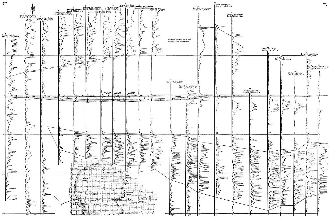
It is well known that local structural features in eastern Kansas that originated at the end of Mississippian time continued to develop by differential movements throughout Pennsylvanian and part or all of Permian time. Stated in reverse, such structures materially increase in structural relief downward to the base of the Mississippian. The pre-Dakota expression of the Oakley anticline at the horizon of the Stone Corral was cancelled by the post-Dakota development of the marginal syncline in areas where the two structural features were in conflict, as shown by a comparison of the Stone Corral structure map (Pl. 1) and the Stone Corral-Dakota thickness map (Pl. 3A). In view of the possibility that the Oakley anticline with its probable increased structural relief in depth may not have been obliterated on the older rocks by the marginal syncline, two cross sections (Pls. 4, 5) were drawn across the Oakley anticline. Each cross section, composed of three parts, shows the structure of the top of the Lansing group and the top of the Mississippian rocks at the end of Stone Corral time, at the end of Dakota time, and now.
It must be made clear that the anticlines and synclines of the cross sections are of necessity based on only a few wells and cannot therefore show accurately the structure of the deeper rocks. The actual crests of the anticlines on the deeper rocks may be miles distant from the crests as shown on the cross sections which are intended to show only in a general way the effect of postDakota deformation on earlier structure.
Plate 4a shows the attitude of the top of the Lansing group and the top of Mississippian rocks at the end of Stone Corral time. The cross section reveals a broad arch on the datum beds which is not sharply localized by the logs now available.
Plate 4b shows the structure of the tops of the Stone Corral, Lansing, and Mississippian at the end of Dakota time. The Oakley anticline at the horizon of the Stone Corral is more sharply localized on the cross section than the older rocks because data from the thickness map are included in the cross section. Between wells 3 and 7, Plate 4b shows structural relief of 240 feet on the top of the Stone Corral, 300 feet on the top of the Lansing, and about 360 feet on the top of the Mississippian.
Plate 4c shows the present structure. The post-Dakota marginal syncline has cancelled the structural relief at the horizon of the Stone Corral. The structural relief of the top of the Lansing and the Mississippian is greatly reduced but not obliterated. The highest point is at well 6 which probably is not exactly at the crest of the subsurface anticline. Inasmuch as anticlinal relief is considerably increased below the Mississippian in most areas, it is probable that the structure of pre-Mississippian rocks was less altered than the top of the Mississippian.
Plate 5a shows the relation of the tops of the Lansing group and the Mississippian rocks to the Oakley anticline at the end of Stone Corral deposition. As in Plate 4a (cross section A-A'), Plate 5a reveals broad low arching on the Lansing and on the Mississippian.
By the end of Dakota time, as shown in Plate 5b, the anticline had become more sharply localized at or near well 4 at the tops of the Stone Corral, Lansing, and Mississippian.
Plate 5c shows the present relations of the datum beds on the same line. The marginal syncline has almost but not completely erased the structure of the Oakley anticline at the horizon of the Stone Corral without cancelling out the deeper structure at the tops of the Lansing and Mississippian. In view of the usual increment of structural relief on anticlines beveled at the end of Mississippian time, the pre-Mississippian structure on the Oakley anticline, although modified, was probably strong enough to have survived the interference of the post-Cretaceous marginal syncline although the position of the crest may have been shifted.
The cross sections A-A' (Pl. 4) and B-B' (Pl. 5) show that structurally high areas in the deeper rocks underlie a syncline at the horizon of the Stone Corral and Cretaceous rocks. Under certain conditions of superposition a downward readjustment of the crest of an older anticline by a later syncline could have resulted in two parallel anticlines as suggested by the hypothetical relations shown in Figure 12.
Figure 12—Diagrams illustrating the effect of a hypothetical syncline symmetrically imposed on an older broad anticline. A-A', original anticline in older rocks; B-B', syncline of later date; C-C', effect of synclinal warping on the earlier anticline. Asymmetrical superposition of the syncline and differences in the structural relief of the anticline and syncline produce different results.
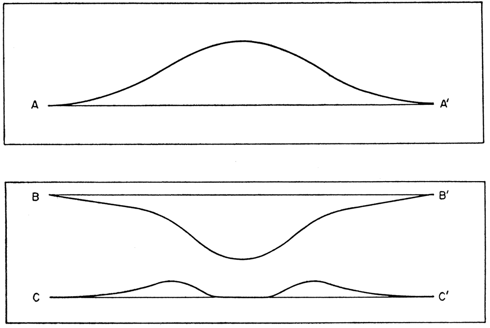
Plate 6 shows, in skeleton form, the present relations of datum beds of Cretaceous and older rocks on a line from north to south in the Western Kansas basin and Hugoton embayment. The Cretaceous and upper Permian rocks show a regional dip toward the north in the Western Kansas basin. Pennsylvanian and older rocks have a regional dip toward the south in the deeper parts of the Hugoton embayment. It is obvious that in Dakota time the southerly dip of the older rocks was greater than at present by the amount of northerly dip of the Dakota.
In eastern Kansas, the axis of folds paralleling the Nemaha anticline, which trend slightly east of north, and those paralleling the Central Kansas uplift, which trend northwest, are almost at right angles. Movements conforming to both trends of deformation were initiated before the end of Mississippian time but the major development of both occurred between the end of Mississippian time and the initial deposits of the Pennsylvanian rocks in eastern Kansas (Lee, 1953).
These conflicting elements of folding seem to have been in response to structural disturbances in distant areas. The uplift and folding were induced by differential movements and may have developed independently of each other as opposing stresses were relieved, separately or contemporaneously.
Secondary anticlines paralleling the Nemaha anticline developed on both sides of its axis but they are most frequent and structurally of greatest relief in the constricted area between the Nemaha anticline and the southeastern end of the Central Kansas uplift.
Rocks younger than the Permian have been eroded from these areas and, in their absence, it has been assumed that activity of the Nemaha anticline and the parallel folds ceased before the end of the Permian. The earthquake tremors of April 9, 1952, were felt throughout a belt 200 to 250 miles wide following the trend of the Nemaha anticline from north of Omaha to and beyond Oklahoma City (Lee, 1954). Inasmuch as the tremors were not reported outside this belt, it must be assumed that deep-seated adjustments are still being made on this structural feature and probably also on parallel secondary folds.
Oil-producing anticlines that have trends paralleling the Nemaha elements of deformation occur on the northern margin of the Central Kansas uplift in Phillips, Rooks, and Russell Counties. These anticlines are revealed on the structure maps of both the Dakota and the Stone Corral and give evidence of earlier history of development by the increase of structural relief in depth. For example, the Fairport anticline, which is represented as a northerly plunging anticline on both Stone Corral and Dakota structure maps (Pls. 1, 2A) clearly indicates structural movement in early Pennsylvanian time and inferentially at the end of the Mississippian. In view of the probability of post-Permian activity on the Nemaha anticline, it seems likely that these northerly trending anticlines, although remote, were elements of the Nemaha pattern of folding. The southern extension of these north-south anticlines is interrupted or modified where they come into conflict with northwest-trending elements of the Central Kansas uplift.
Regional arching of the Central Kansas uplift ceased at about the time of the deposition of the Hutchinson salt member of the Wellington formation when a synclinal salt basin extended entirely across the Central Kansas uplift. Thereafter, through Permian time the area of the uplift was differentially tilted toward the Hugoton embayment without material arching but some local folds paralleling the Central Kansas uplift continued to develop even after Dakota time.
The contact of the Pennsylvanian with the Arbuckle, which has been a prolific source of oil, is characterized by topographic relief and deep weathering of the Arbuckle. The topographic relief is, in part, dependent on the structure of the under lying rocks which were truncated by post-Mississippian erosion. The somewhat eccentric pattern of many areas of oil production may be due in part to the conflict between the elements of Nemaha deformation and those of the Central Kansas uplift but more likely is in greater measure due to the combination of structural elements of folding and topographic relief of the producing zone.
During the early part of Permian time the crest of the Central Kansas uplift was being tilted southwestward toward the Hugoton embayment with retreat of the crest northeastward (Lee, 1953, fig. 2). Although the regional southwesterly dip of the uplift amounted to only 15 or 20 feet per mile, it must have caused some rearrangement and secondary migration of oil already trapped in areas of low closure, whether structural or topographic. This tilting of the crest may explain the relatively greater abundance of oil on the upper or northeastern side of the Central Kansas uplift than in anticlines on its southwestern side. The inference is strong that much of the oil on the northeastern side of the uplift reached its present position during or after the southwestern tilt of the Central Kansas uplift.
In general, Arbuckle pools on the Central Kansas uplift show little relation to the structure of the Stone Corral, although there are some exceptions. The somewhat sinuous Hall-Gurney pool seems to underlie a low northwesterly plunging anticline at the horizon of the Stone Corral whose relation to the producing area must have been closer before the post-Cretaceous northerly dip.
Pools producing primarily from Pennsylvanian rocks, some of which also produce from the Arbuckle, are more closely related to Stone Corral structure. Many such pools, although they occur on northwesterly plunging anticlines, are eccentric to the Stone Corral structure as depicted on the map. Detailed studies of some of these pools reveal a close relation between the structure of the Stone Corral and production. In view of the fact that the contouring of the Stone Corral is generalized, it is probable that there is a closer relation between producing areas and Stone Corral structure than shown on Plate 1. Some pools that underlie Stone Corral anticlines are not revealed by Dakota structure as in the case of the Wakeeney anticline which has a closure of about 20 feet on the Stone Corral but is unrelated to Dakota structure. Other producing areas, like those on the southeastern end of the Cambridge arch, occur beneath southeasterly plunging anticlines of both the Dakota and Stone Corral. In general, however, the structure of the Dakota and younger Cretaceous rocks should be regarded with distrust unless supported by similar Stone Corral structure. In the Western Kansas basin where the original structure of the Oakley anticline has been altered by the conflicting post-Cretaceous deformation, Stone Corral structure may not be as trustworthy a guide to anticlines in the older rocks as elsewhere.
The Chautauqua arch of southeastern Kansas had its greatest period of development in post-Arbuckle time and ceased to be active before Mississippian time. Although minor movement of the Central Kansas uplift occurred before Mississippian time, its greatest development took place at the end of the Mississippian (Lee, 1953, p. 20). Arching of the uplift continued during, Pennsylvanian and early Permian time after which the area was tilted toward the Hugoton embayment. The Cambridge arch was active during late Permian time and continued to develop through the Cretaceous and later. A series of broad anticlinal uplifts thus progressed from the south along a northwesterly curving arc. Development of the Chautauqua arch at the southeast end of the arc came to an end before the major development of the Central Kansas uplift and the Cambridge arch continued active long after arching of the Central Kansas uplift ceased.
The Hugoton embayment of the Anadarko basin, like the Central Kansas uplift, was already developing during Mississippian time and continued active through Pennsylvanian and Permian time.
The Las Animas arch, except in so far as it formed the western limb of the Hugoton embayment, had little effect on the regional structure of western Kansas until after Cretaceous time. A syncline marginal to the northeast flank of the arch is first revealed during the interval between Dakota. and Niobrara deposition but was more sharply developed after Cretaceous time.
The Western Kansas basin represents in altered form the northern part of the Hugoton embayment. The post-Permian northerly tilt of the region reversed the low, original southerly dip of the rocks of the upper part of the Permian and turned the head of the embayment into a northwesterly plunging arm of the Denver basin without reversing the steeper dips of the older rocks which still faintly reflect the configuration of the Hugoton embayment.
The Oakley anticline seems to have developed contemporaneously with the Hugoton embayment. Its activity was brought to a close prior to Niobrara deposition by the development of the syncline marginal to the Las Animas arch which in part at least followed the same trend as the Oakley anticline. This syncline modified the earlier anticlinal structure of the Stone Corral and older rocks.
Other less prominent pre-Cretaceous structural features of lesser structural relief must have been altered in some degree by post-Cretaceous structural folds and by regional dip. Where later anticlines intersected older anticlines the structural relief was increased. Other pre-Cretaceous anticlines were modified according to the character of later warping. East of the Las Animas arch, where pre-Cretaceous structures were altered mainly by the post-Cretaceous northerly regional dip of 7 feet per mile or less, not much shifting of the crests of anticlines resulted from this cause at the horizon of the Stone Corral or in the older rocks. The positions of the crests in the older rocks in reference to the Stone Corral shifted to a somewhat greater extent in the opposite direction by the southerly divergence of 10 to 20 feet per mile between the Stone Corral and the base of the Mississippian. On the flank of the Las Animas arch (Pl. 2A) the postCretaceous northeastern dip of 20 feet per mile recorded on the Dakota must have induced greater shifting of the crest in the older rocks than farther east where the post-Cretaceous dips were only about 7 feet per mile. As a result of the discordance between the post-Cretaceous structure and the original structure of the Stone Corral and older rocks, post-Permian rocks do not everywhere reveal the position and crests of anticlines in the older rocks. The relation of the Stone Corral structure to the structure of the older rocks is probably closer on the east flank of the Hugoton embayment than on the west flank.
Bass, N. W., 1926, Geologic investigations in western Kansas: Kansas Geol. Survey, Bull. 11, p. 1-96. [available online]
Batchelor, J. W., 1952, Structure of the Stone Corral formation in Kansas; Structure of the Dakota formation in Kansas, unpublished manuscript in files of Kansas Geol. Survey
Darton, N. H., 1905, Preliminary report on the geology and underground-water resources of the Central Great Plains: U.S. Geol. Survey, Prof. Paper 32, 409 p., figs. 1-18, pls. 1-72 (including maps). [available online]
Darton, N. H., 1918, The structure of parts of the central Great Plains; in, Contributions to economic geology, 1918, part II, mineral fuels, David White, G.H. Ashley, and M.R. Campbell, eds.: U. S. Geol. Survey, Bull. 691-A, p. 1-26 [available online]
Elias, M. K., 1931, The geology of Wallace County, Kansas: Kansas Geol. Survey, Bull. 18, pp. 1-254. [available online]
Fuenning, Paul, 1942, Thickness and structural study of major divisions of Cretaceous System in Nebraska: Am. Assoc. Petroleum Geologists Bull., vol. 26, no. 9, p. 1517-1536
Jewett, J. M., and Schoewe, W. H., 1942, Kansas mineral resources for wartime industries: Kansas Geol. Survey Bull. 41, pt. 3, p. 69-180, fig. 1-13. [available online]
Landes, K. K., and Ockerman, J. W., 1930, The geology of Mitchell and Osborne Counties, Kansas: Kansas Geol. Survey, Bull. 16, pp. 1-55, fig. 1, pls. 1-15. [available online]
Lee, Wallace, 1953, Subsurface geologic cross section from Meade County to Smith County, Kansas: Kansas Geol. Survey Oil and Gas Investi. 9, p. 1-23.
Lee, Wallace, 1954, Earthquake and Nemaha anticline: Am. Assoc. Petroleum Geologists Bull., vol. 38, no. 2.
Maher, J. C., 1953, Permian and Pennsylvanian rocks of southeastern Colorado: Am. Assoc. Petroleum Geologists, Bull., v. 37, p. 913-939.
McCoy, A. W., III, 1953, Tectonic history of the Denver Basin: Am. Assoc. Petroleum Geologists, Bull., v. 37, p. 1873-1893.
Moore, R. C., Frye, J. C., Jewett, J. M., Lee, Wallace, and O'Connor, H. G., 1951, The Kansas rock column: Kansas Geological Survey, Bulletin, no. 89, 132 pages [available online]
Moore, R. C., Frye, J. C., Jewett, J. M., Lee, Wallace, and O'Connor, H. G., 1952, The Kansas rock column: Kansas Geological Survey, 1 sheet
Plummer, Norman, and Romary, J. F., 1947, Kansas clay, Dakota formation: Kansas Geol. Survey, Bull. 67, p. 320
Rubey, W. W., and Bass, N. W., 1925, The geology of Russell county, Kansas: Kansas Geol. Survey, Bull. 10, pt. 1, pp. 1-86, figs. 1-11, pls. 1-5 [available online]
Wing, M. E., 1930, The geology of Cloud and Republic Counties, Kansas: Kansas Geol. Survey, Bull. 15, pp. 1-49, figs. 1-2, pls. 1-18. [available online]
Kansas Geological Survey
Placed on web Sept. 14, 2018; originally published in 1954.
Comments to webadmin@kgs.ku.edu
The URL for this page is http://www.kgs.ku.edu/Publications/Bulletins/OGI11/index.html