Kansas Geological Survey, Mineral Resources Circular 6, originally published in 1937
Next--Letters G through O...
Originally published in 1937 as Kansas Geological Survey Mineral Resources Circular 6. This is, in general, the original text as published. The information has not been updated. An Acrobat PDF version (33 MB) is also available.
This publication not only serves a special purpose, but is also an excellent example of the usual method of work employed in the performance of the function of state planning. This booklet is the joint product of skill and knowledge found at the University of Kansas and the facilities and knowledge at hand in the Kansas State Planning Board.
This is designed as a ready reference manual from which the inquirer can determine the availability of mineral resources which he might need in the development of an industry. Since the present and future welfare of the people of Kansas depends in considerable measure on the creation of a balanced economy which would result from industrial growth, it is hoped that the planning board may contribute to this end. This is the first of a series of booklets which will be issued.
The University of Kansas, through its faculty members, is a great center of research and investigation in addition to performing its function as an educational institution. The same is true of the other state schools. One of the services which the state planning board undertakes to perform, is that of aiding these institutions in the dissemination of this research so that the opportunities which it reveals may become common knowledge and add to the common welfare.
David J. Teviotdale
Kansas State Planning Board
The relative importance of Kansas as a mineral-producing state is often not appreciated, even by citizens of the state. Figured over a 5-year period this state ranks tenth in annual value of mineral products sold. It out ranks all of the famous mining states of the West, except California, and is far ahead of Alaska. Kansas ranks first in volcanic ash production, third in zinc, and fourth in salt and petroleum.
Within the state the leading mineral products in annual value are petroleum, natural gas, coal, zinc, salt, stone, natural gasoline, sand and gravel, clay products, lead, gypsum, and volcanic ash, in the order named.
The mineral industry is second only to that of agriculture in Kansas.
This booklet has been prepared at the request and with the cooperation of the State Planning Board, primarily for the use of the Industrial Committee of the State Chamber of Commerce. It is hoped that the cataloguing of mineral resources by counties will call attention, to the opportunities present in different communities, and thereby lead to industrial expansion in Kansas.
The county summaries are by no means complete. In man7 instances additional details can be found in other publications of the Kansas Geological Survey. Furthermore, there no doubt are potential mineral resources in some counties which have not yet been discovered or investigated. Studies of the occurrence and utilization of chalk, clay, chat, volcanic ash, bentonite, potash, and other Kansas minerals are to be carried on by the staff of the State Geological Survey during the coming biennium.
A brief discussion of the availability of water is given for each county because this substance is not only a very important mineral resource, but is also essential to industrial development.
Many bulletins, circulars, reports, journals, and unpublished manuscripts have been consulted in the preparation of this booklet. The reports of the Kansas Geological Survey consulted include especially: Bulletins 6 (part 7), Oil and Gas Resources of Anderson County, Homer Charles [available online]; 10, The Geology of Russell County Kansas, with special reference to oil and gas resources, W. W. Rubey and N. W. Bass [available online]; 11, Oil and Gas Possibilities in Western Kansas, N. W. Bass [available online]; 12, The Geology of Cowley County, with special reference to the occurrence of oil and gas, N. W. Bass [available online]; 13, Underground Resources of Kansas, R. C. Moore and K. K. Landes; 14, Volcanic Ash Resources of Kansas, K. K. Landes [available online]; 15, The Geology of Cloud and Republic Counties, Kansas, Monta E. Wing [available online]; 16, The Geology of Mitchell and Osborne Counties, Kansas, Kenneth K. Landes; 18, The Geology of Wallace County, Kansas, M. K. Elias [available online]; 19, The Geology of Ness and Hodgeman Counties, Kansas, R. G. Moss [available online]; 20, Subsurface Studies in Northeastern Kansas, John W. Ockerman [available online]; and 21, The Geology of Johnson, Miami and Wyandotte Counties, Kansas, Norman D. Newell and John M. Jewett [Johnson, Miami online, Wyandotte online]; Mineral Resource Circulars 1, Oil and Gas Resources of Kansas in 1927, L. W. Kesler; 2, Oil and Gas Resources of Kansas in 1928, 1929, and 1930, Anthony Folger and Roy Ball; 3, Oil and Gas Resources of Kansas in 1931 and 1932, Edward A. Koester; and 5, Rock Wool Resources of Kansas, Norman Plummer [available online]; and Circulars 3, Diatomaceous Marl from Western Kansas, a Possible Source of Hydraulic Lime, M. K. Elias [available online]; 4, Mineral Resources of Wyandotte County, Kansas, Norman D. Newell [available online] ; and 5, Preliminary Report on Ground Water Resources of the Shallow Water Basin in Scott and Finney Counties, Kansas, R. G. Moss [available online]. Also utilized was unpublished material, including manuscripts on Road Materials of Kansas by K. K. Landes, Asphalt Rocks in Eastern Kansas by J. W. Ockerman, and Origin of the Shoestring Sands or Greenwood and Butler Counties, Kansas, by B. W. Bass. The new geologic map of Kansas was of inestimable aid in preparing this report.
Miscellaneous publications consulted include Kansas Coal, Engineering Bulletin 13 of the University of Kansas, by C. M. Young; reports on the water resources of drought counties (typewritten) prepared by the Kansas Emergency Relief Committee under the supervision of Ogden S. Jones; mimeographed report on water supplies of Kansas by the State Board of Health; annual reports and manuscript report on the coal industry prepared by the State Commissioner of Labor; the Oil and Gas Journal, especially the annual review number; the Oil Weekly, especially the western Kansas number; and reports of the U. S. Bureau of Mines, including the Minerals Yearbook and statistical compilations especially prepared for the files of the State Geological Survey of Kansas.
I greatly appreciate the cooperation and assistance given in the preparation of this booklet by members of the staff of the State Planning Board, especially Jay Besore. The following individuals furnished important memoranda which have been incorporated into this report: George E. Blakeley, Commissioner of Labor; Nels Anderson, Chief Engineer, State Corporation Commission; Harold Allen, Materials Engineer, State Highway Department; H. D. Barnes, State Highway Engineer; W. L. Stryker, consulting geologist, Fredonia, Kansas; Kenneth Spencer and C. Y. Thomas of the Pittsburg-Midway Coal Mining Company; Evan Just, Secretary Tri-State Zinc and Lead Ore Producers Association; and E. T. McKnight, O. S. Geological Survey. The drafting of illustrations was done by Donald Dowers and Robert Garrett. Max Shoemaker assisted in the compilation of information in regard to the newer oil and gas discoveries. I am very grateful to all of these individuals for their assistance.
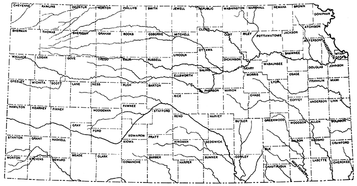
Index map showing location of Kansas counties
Allen County was one of the first counties in the state to produce oil and gas. Gas was discovered in the Iola district in 1873, and in succeeding decades many additional gas and oil fields were discovered in other parts of the county. The three leading districts are: (1) the southwestern part of the county, in the vicinity of Humboldt and southward into Neosho County; (2) the Iola district, mainly gas; and (3) scattered pools in eastern Allen County, especially in the vicinity of Moran. Production is obtained mainly from sandstones in the Cherokee shale formation, at depths ranging from 600 to 900 feet. Several shale gas wells were drilled in the southwest corner of the county a few years ago.
The oil fields of Allen County produced 116,870 barrels of oil during 1935, the last year for which statistics are available. Most of this oil comes from small wells that have been producing for many years.
The latest development in the county is the installation of "water drive" equipment to increase the oil yield, A project of this character is now being carried on in an old field northeast of Moran. Although the county has been widely explored for oil and gas in the Pennsylvanian rocks and has produced in the aggregate a considerable volume of these materials, the increased use of special production methods will no doubt keep Allen County in the producing column for many years more. In addition there is a possibility of deeper production. But few wells in the county have tested the "Siliceous lime."
Portland cement is produced in Allen County in two plants, one at Iola and the other at Humboldt. A third plant at Mildred, in the northeastern part of the county, has been idle for several years and is being dismantled. The Iola limestone, which is used in making cement in Allen County, lies at or close to the surface over a large part of the county. The reserves in cement-making materials are therefore very large.
Three operators (one the cement company at Humboldt) reported the production of crushed limestone in 1935. Most of this was used in road metal and concrete, the balance being marketed for agricultural purposes. A large quantity of limestone is available over most of the county.
A plentiful supply of red burning clay and shale is available in Allen County. One plant at Humboldt manufactures bricks.
Large supplies of potable water are to be obtained in Allen County from the surface only. The cities of Iola and Humboldt obtain water from the Neosho River, which drains the western part of the county,
Anderson County reached a peak in oil production in 1926 with a total of over one million barrels. Subsequently a, steady decline has taken place, and in 1935 the production for the year was but a little over 280,000 barrels. The oil and gas are obtained from sands in the Marmaton group and in the Cherokee shale, especially the Bartlesville sand, from depths of less than 1000 feet as a general rule. Some of the most prolific pools produce from "Shoestring sands", which are very narrow and elongate sand bodies completely surrounded by shale. One such sand body extends (with some gaps) from a point a few miles southwest of Garnett in a northeasterly direction east of the city to the northeastern corner of the county. Another shoestring sand makes the Bush City oil pool, which extends from central Anderson County to Bush City and then trends in a northeasterly direction to the county line. Other oil and gas fields have been found in the vicinities of Welda and Colony, and in the southeastern part of the county.
The oil fields of Anderson County have yielded the greater part of the oil that can be obtained by usual methods. It is anticipated that the use of water drive (now being practiced southeast of Garnett) will greatly increase the total recovery from these relatively shallow fields. New Pennsylvanian fields may yet be discovered, and in addition, the as yet largely untested "Siliceous lime" may contain oil in this part of the state.
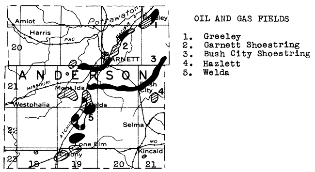
One company, the Virginia Oil Company, reported the production by compression methods of natural gasoline during 1935 from gas obtained in the Bush City field.
A very thick limestone series, the Stanton-Plattsburg, outcrops across Anderson County from north to south and has been exploited by a large quarry north of Garnett. Stone quarried in Anderson County during 1935 was used for road metal and concrete, railroad ballast, riprap, and for agricultural purposes. The supply of rock available is practically inexhaustible.
As is the case in most parts of eastern Kansas, the water in the bed-rock formations is highly mineralized and large municipal and industrial supplies of water in Anderson county must be obtained from surface runoff.
The uplands of central and south-central Anderson County contain high terrace flint gravel deposits which have been but little exploited as yet.
Two small coal mines operated in Atchison County during 1935. The coal lies in the Lawrence shale formation and crops out along the bluffs and in the ravines adjacent to the Missouri River. Several decades ago a 36 inch bed of coal occurring in the Cherokee shale at a depth of 1123 feet was mined. The mine was eventually abandoned because of the large volume of water encountered which entailed excessive pumping costs.
Sand and gravel used in the construction of buildings and highways are obtained from the bed of the Missouri River, which forms the eastern boundary of Atchison County. The supply of sand and gravel on the river bed is replenished during times of high water.
The city of Atchison and industrial plants obtain water directly from the Missouri River. In the central and western parts of the county water is obtained from porous streaks in the valley alluvium and from the glacial deposits, which veneer the uplands in this county.
Rock samples collected in Atchison County have not yet been tested for rock wool, but there is little doubt that suitable rock for the manufacture of this important insulating material can be obtained.
So far only two deep tests for oil or gas have been drilled in Atchison County. One of these was a diamond-drill hole which was drilled in Atchison to a depth of 1,352 feet. It penetrated into the "Mississippi lime". The other well was drilled near the southeastern corner of the county, and reached a total depth of 3,085 feet. It encountered pre-Cambrian granite and schist below about 2,900 feet, Central and western Atchison County have not been tested for oil or gas.
Gas was first encountered in Barber County in January: 1927, in the discovery well of the Medicine Lodge pool, in T. 33 S., R. 13 W., southwest of the city of Medicine Lodge. The first oil discovery was in the Whelan pool, a short distance northeast of Medicine Lodge, in November, 1934. Oil was found on the southwest flank of the Medicine Lodge gas field in March, 1937. The oil production for Barber County (Whelan pool) has been: 1934 (November and December only), 2,848 barrels; 1935, 14,582; 1936, 24,686 barrels.
The Medicine Lodge field produces from the Viola lime at depths of about 4,800 feet. A total of 7,200 acres produce gas. The oil is found beneath 120 acres. The Whelan pool is producing from the Mississippi chat at a depth of about 4,400 feet. At the present time the pool has but two producers, and has no outlet for its oil other than by truck. A third pool in Barber County, the Aetna, was discovered in September, 1935. This is now a two-well gas pool, with production coming from the Viola lime at a depth of a little over 5,200 feet. It is dormant at the present time due to lack of pipe-line outlet.
Most of the western half of Barber County, and the southeastern part, were being actively leased during 1936.
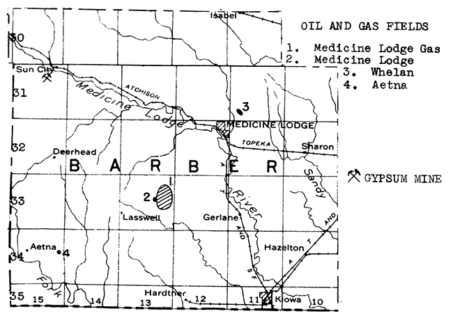
Gypsum has been mined in Barber County for many years, but a large reserve is still available. The Best Bros. Keene's Cement Company mines gypsum by modern mining methods in the hills south of Sun City. Most of this gypsum is then transported by rail to the company's plant at Medicine Lodge, where it is calcined and made into various plasters, including Keene's cement.
Much of the surface and ground water of Barber County is mineralized because of the presence of gypsum and salt in the bed-rock formations. However, an ancient stream deposit covers much of eastern Barber County, from parts of which large quantities of usable water can be obtained. The northern end of the county is covered with Tertiary formations which likewise contain ground water.
Central and northern Barber County are underlaln by salt beds with an aggregate total thickness in excess of 500 feet. The thickness of the salt diminishes to the south, but according to drill records some salt underlies the entire county.
Sand and gravel deposits occur along Medicine Lodge River near the town of Medicine Lodge, and in a tributary valley about 6 miles north of town.
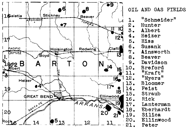
The first commercial oil well was completed in Barton County in March, 1930. Another field was discovered in 1931 and a third pool in 1932. In the four subsequent years 13 new oil and gas fields have been discovered in the county, making a total of 16. The names and positions of these pools are shown on the accompanying map. The, average depth to production is about 3,300 feet. The Heizer and Hiss pools are producing from the Kansas City limestone, the Beaver, Ehly and Feist from sandstone or conglomerate at the base of the Pennsylvanian series, the Albert oil and gas field from a basal Paleozoic sandstone, and the remaining pools from the "Siliceous lime".
Barton County is the scene of a very active drilling play at the present time. Inside locations remain to be drilled in some of the newer fields. Not all of the fields have been completely outlined by dry holes as yet, and there are many parts of the county that remain to be tested.
The Arkansas River, which curves through southern Barton County, has cut its course through Dakota sandstone, and in consequence its flood plain is sandy. Furthermore almost unlimited supplies of sand and gravel can be obtained from the river bed itself. Paving sand was produced in this county in 1935.
Large quantities of water are available over Barton County by means of shallow wells dug or drilled into the alluvial deposits, which are very widespread in the southern half of the county, and into the sandstone beds of the Dakota formation.
From three to four hundred feet of rock salt underlies Barton County.
The Moran and some of the other eastern Allen County pools extend across the line into western Bourbon County. The Walnut-Hepler oil field lies across the western end of the line separating Crawford from Bourbon County. In addition some small and isolated oil fields occur in Bourbon County, especially in the western part. A shoestring oil field was discovered and extenSively drilled in the northwestern corner of the county in 1933 and 1934. Repressuring is now being practiced in this field.
During the last decade the oil production of Bourbon County has ranged from 5,300 barrels up to nearly 22,000 barrels. The production during 1935 was 7,136 barrels.
The oil and gas of Bourbon County occur mainly in sand within and at the base of the Cherokee shale. This formation lies at a depth of but a few hundred feet in the western part of the county and is exposed in the southeastern part. Six gas fields with a northwest-southeast trend have been developed in eastern Bourbon County, mainly since 1928. The producing sands lie at depths as shallow as 250 feet. The wells range in initial flow from 65,000 to 260,000 cubic feet, with a pressure of 34 pounds.
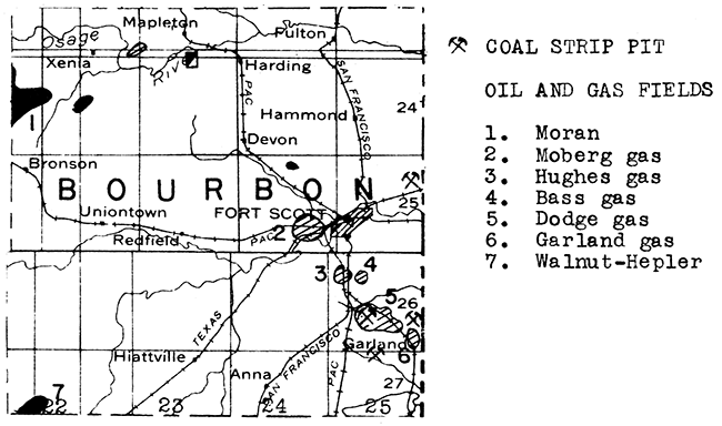
The upper Cherokee coals occur at and near the surface in southeastern Bourbon County. The mining of coal increased in the county during 1936. Six strip mines and one shaft mine produced 21,726 tons of coal during that year.
The Fort Scott limestone which lies immediately above the Cherokee shale is mined at a plant north of Fort Scott and burned to produce natural cement. This is the only natural cement plant in operation in Kansas. The Fort Scott limestone is extensively exposed over eastern Bourbon County.
Crushed limestone was marketed by two producers in eastern Bourbon County during 1935. Most of this limestone was used in road metal and concrete. Other uses include riprap, railroad ballast, and agricultural limestone. A local sandstone occurring in the Bandera shale is quarried near the town of Bandera, mainly for flagging.
Brick and pottery are made in Fort Scott from local clay deposits. Other shales and clays occur in the county which are not exploited.
The deeper ground waters of Bourbon County are too highly mIneralized for use. The. municipal supply at Fort Scott is obtained from impounded surface water.
Experiments by the State Geological Survey have shown that satisfactory rock wool can be blown from the rock that is being quarried for natural cement and brick manufacture in the vicinity of Fort Scott.
The same formations that contain commercial deposits of rock asphalt in Linn County to the north and in western Missouri extend southwestward into Bourbon County. It is possible that asphalt deposits may occur at and near the surface in northern Bourbon County.
Most of the water obtained in Brown County comes from valley fill aquifers. This section of Kansas is veneered with glacial deposits, and consequently much of the valley alluvium consists of coarse sand and gravel, in which large quantities of water are stored. The glacial till itself is too erratic in texture to be a consistent source of ground water, but glacial outwash gravels yield abundant water. Water is also present in the bed-rock formations, but as a general rule is mineralized at depths below 200 feet.
The presence of glacial drift over most of the surface of Brown County has retarded geological exploration for favorable places in which to drill test wells for oil and gas. Several decades ago a diamond drill hole was put down at Horton to a depth of 1,108 feet. Only the Pennsylvanian beds were penetrated by this well.
Limestones are exposed in the stream valleys that penetrate through the glacial drift. Quarry sites have been found in southeastern and west central Brown County.
Sand and gravel deposits occur in the southeastern and south central parts of the county.
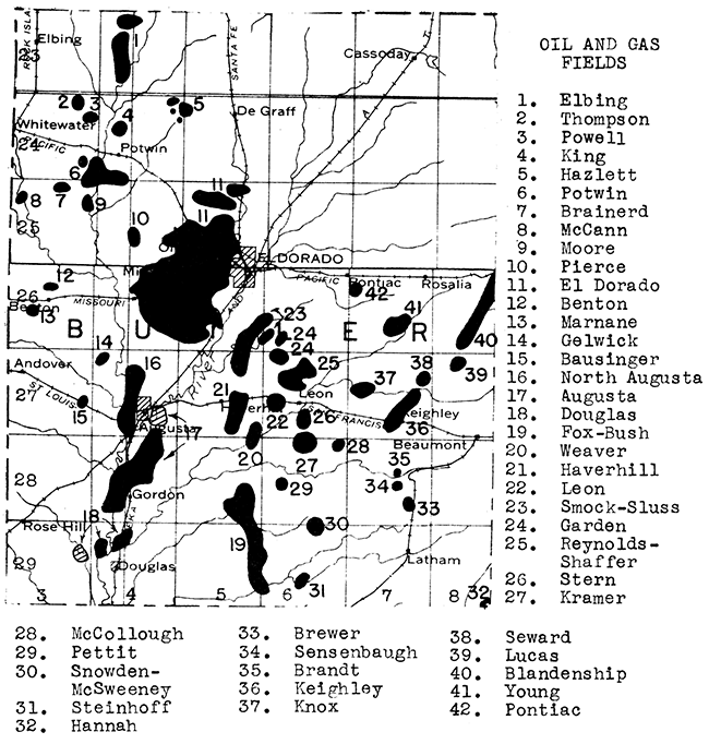
Kansas first became an important oil state in 1917 when a 20,000 barrel well was completed in what is now the El Dorado field. For several years this field produced most of the state's oil and was in addition an important factor in world production. Even today, nearly 20 years after discovery, the El Dorado field is the third largest field in Kansas (1936 production), with an annual yield in excess of 3 1/2 million barrels. Repressuring by air drive has been practiced for over a decade in the 650 foot sand in this field.
Since 1917 many other oil and gas fields have been discovered in Butler County. To the south the Augusta field produces from an anticline that is only slightly smaller than the El Dorado anticline. Both of these oil-producing sectors overlie the buried Granite Ridge which crosses Kansas from north to south between Nemaha and Sumner counties. The El Dorado and Augusta pools produce some oil and gas from Lower Pennsylvanian rocks, but the greater part of the yield comes from Ordovician rocks which immediately overlie the buried summits of the granitic mountains. To the west in western and northwestern Butler County are about a dozen fields, which produce from the "Mississippi lime" on the flank of the granite uplift. The largest of these fields is the Potwin. To the east are nearly a score of fields producing from the Bartlesville sand. Some of these, near the eastern boundary of the county, produce from "shoestring" sand bodies which lie on the southwestern extension of the Sallyards trend of Greenwood County.
The oil production of Butler County has been in the neighborhood of from 6 to 7 million barrels annually during the last few years. A little over half of this production comes from the El Dorado field. The balance is the aggregate from the many scattered oil pools in the county.
One plant at El Dorado produces gasoline from natural gas by the compression process, and a larger plant at Gordon uses the absorption method of obtaining natural gasoline.
One of the largest gravel deposits in southern Kansas occurs in Butler County between Douglas and the Cowley County line. The gravel caps the uplands and was probably deposited by late Tertiary streams that flowed over this area. The gravel is cherty and was apparently derived from the lower Permian rocks.
Large users of water in Butler County, including, the cities of El Dorado and Augusta, have found it necessary to impound surface supplies in order to obtain the desired quantity and quality of water.
The limestone now being quarried in the Dolese quarry 2 miles east of El Dorado is too high in carbon-dioxide to be used in blowing rock wool without mixing it with clay or shale obtained from near-by deposits. However, there is a strong possibility that the rock below the present quarry floor could be used for this purpose.
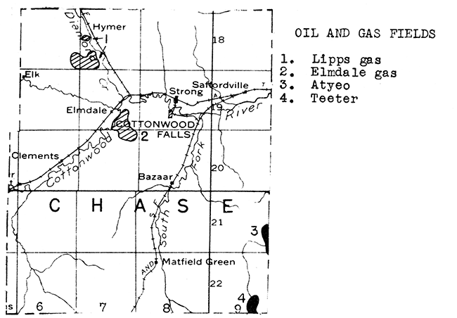
Many thousands of dollars have been spent in southern Chase County on dry holes drilled in the hope of finding production similar to that obtained in Butler County from above the buried Granite Ridge. The only oil as yet found in Chase County is in the southeastern corner where the Teeter pool extends northward across the county line from Greenwood County and the Browning and Atyeo pools extend westward into Chase County from northwestern Greenwood and southwestern Lyon counties. A few thousand barrels a year from these fields can be credited to Chase County.
Exploration in northwestern Chase County, although as yet unproductive of oil, has resulted in the discovery of two gas fields. One of these, the Elmdale, located in Ts. 19 and 20 S., R. 7 E., has been producing gas for over a decade. It supplies near-by cities. The gas occurs at a depth of about 500 feet in a formation in the Wabaunsee group of Upper Pennsylvanian age. A newer and larger field, the Lipps, lies in the western part of T. 18 S., R. 7 E. and in the southeastern part of T. 18 S., R. 6 E. This field was discovered in 1926. The gas is obtained from a sand in the Lawrence shale at a depth of about 1,200 feet. Individual wells vary in initial production from It million to 5 million cubic feet. At last reports (1929) eighteen producing gas wells had been drilled.
The Cottonwood, Wreford, Florence, and Fort Riley limestones cross the western half of Chase County from north to south. Limestone was produced and used in road metal and concrete in this county in 1935. Three quarry sites occur in the cherty limestones of the Permian in west central Chase County. An old and once very active dimension stone quarry in the Cottonwood limestone lies just south of Cottonwood Falls.
The most important source of water in Chase County at present is the flood plain of Cottonwood River. Coarse streaks within the valley fill yield ample supplies of water for local and municipal use. One bed-rock formation, the Wreford limestone, is an important source of water in the Flint Hills. Attempts to find bed-rock supplies in eastern Chase County have been failures as a general rule.
Oil and gas pools have been found in every township in Chautauqua County except along the western edge. The leading oil fields are grouped in the vicinities of Sedan, Chautauqua and Elgin. The Longton gas field of southeastern Elk County extends southward into northeastern Chautauqua County. Several scattered pools lie northwest of Sedan in T. 32 S., R. 11 E., and T. 32 S., R. 10 E.
An extremely important discovery, not only to Chautauqua County but also to other counties of eastern Kansas, was the discovery in the summer of 1935 of oil in the "Siliceous lime" in the Oliver pool in secs. 1 and 2, T. 32 S., R. 10 E. This well was rated with an initial production of 1,000 barrels a day from a depth of a little less than 2,300 feet. By February, 1936, six producing wells had been drilled into the "Siliceous lime" in this field. About twenty other wells produce from upper pay zones in the same field. Subsequently the "Siliceous lime" was tested beneath the Monett pool northeast. of Sedan, a "Mississippi lime" gas field discovered in 1925. The deep test was a success, and by February, 1936, a half dozen producers had been drilled. One of these wells was estimated to have a potential, of 1,500 to 2,000 barrels daily. The top of the "Siliceous lime" lies at a depth of 1,790 feet in this pool.
Oil production in Chautauqua County reached a peak in 1929, when nearly a million barrels of oil was produced. Production declined, however, and between 1932 and 1935 the annual yield was between 500,000 and 600,000 barrels. The increased production due to discovery of oil in the "Siliceous lime" should push Chautauqua County production to a new peak. It is anticipated that the "Siliceous lime" will be tested in many other fields during the next few months. The outlook for important quantities of Ordovician oil in eastern Kansas is very encouraging at the present time.
Both sandstone and limestone are produced in Chautauqua County. One quarry lies a few miles north of Sedan. Some of the formations that are massive limestones in northeastern Kansas become sandy to the south, and are sandstones in Chautauqua County. Both sandstone and limestone were quarried in this county in 1935 for use as road metal. Limestones are abundant at the surface in the western half of the county.
Municipal and industrial supplies of water are obtained in Chautauqua County by impounding surface drainage and by shallow wells. As a general rule, the deeper bed-rock formations carry mineralized water.
A deposit of volcanic ash has been reported as exposed in a road cut in the NE of the SW of sec. 9, T. 34 S., R. 13 E.
The outstanding zinc-producing district of the United States lies in southwestern Missouri, southeastern Kansas, and northeastern Oklahoma. The Kansas portion of this district lies in southeastern Cherokee County in the vicinity of Baxter Springs. The ore occurs in the Mississippian limestone which crops out in the very corner of the state. With the zinc occurs lead ore, which is likewise mined. "Chat" is a colloquial term for chert which is mixed through the zinc and lead ore and is separated during the milling process. It is used as railroad ballast, road surfacing and in concrete aggregate. The total zinc and lead production from 32 mines in Kansas in 1936 was 119,022 short tons. During the same year 10 tailing-mills produced 24,714 tons of zinc. It has been estimated that the Tri-State district contains a six year supply of tailings yet to be treated. During the past decade Kansas has varied from second to fourth in rank among zinc-producing states.
No data are available in regard to the amount of zinc and lead ore yet to be mined from the Kansas part of the Tri-State district. Three potential sources of ore in addition to that being mined are known. One of these is a tract, explored by the core drill and known to be ore-bearing, about 3 miles north of the State line and 1 mile west of State Highway No. 7. It lies about 2 miles north of present production. A second tract, likewise core drilled, lies west of Treece and south of Melrose. Barren ground lies between both of these tracts and the Treece ore deposit. The third possibility for additional ore is its occurrence at stratigraphically lower levels than those now being exploited. One Kansas mine, the Ballard (3 miles southwest of Baxter Springs), is now working an ore body in the Grand Falls chert layer. This deeper ore may underlie other mines in the district.
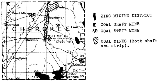
The Cherokee formation, with several commercial beds of coal, crosses Cherokee County from northeast to southwest. The coal is mined by both open cut and underground mining methods. Five strip mines in Cherokee County produced 477,496 tons of coal during 1936. Thirty-eight shaft mines operated during the year with a production of 76,038 tons, or a total for the county of over a half million tons of coal. Additional detail on the coal industry of Kansas is given in the discussion of coal under Crawford County.
The only thick limestones to outcrop in Cherokee County are the Mississippian in the southeastern corner and the Fort Scott in the northwestern corner. A small production of limestone was reported for 1935. Several sandstone beds occur in tine Cherokee formation and some have been exploited, but no report of production was made for 1936.
Sand and gravel are sporadically produced in Cherokee County. The deposits are formed through the weathering and transportation of chert occuring in the Mississippian limestone.
A new industry in Kansas was established in 1935 when a concentrating plant to extract iron pyrites from mine refuse was constructed, by the Pittsburg and Midway Coal Mining Company at West Mineral, in Cherokee County. The iron sulphide (pyrite and marcasite) occuring in the coal had hitherto been allowed to go to waste. This plant has a capacity of 50 tons of mine refuse per hour, and produces a product containing about 48 per cent sulphur.
Cherokee is one of the few counties in eastern Kansas where potable supplies of ground water are availabie from bed-rock formations. The Mississippian limestone, which crops out in the southeastern corner and underlies the rest of the county, contains an abundant supply of water. This water contains sulphur compounds, but is nevertheless usable.
All but the northern part of Cheyenne County is underlain by the Ogallala formation of Tertiary age, in which occurs an abundant supply of sheet water. In addition, the Republican River cuts across the northwestern part of the county, and ground water is available within its wide valley fill.
Cheyenne County has not yet been tested for oil and gas. Gas occurs in the Upper Cretaceous formations a short distance to the northwest at Beecher Island in Yuma County, Colorado. Not only does this horizon underlie Cheyenne County but also most, if not all, of the older and deeper formations which produce elsewhere in western Kansas lie beneath the surface in Cheyenne County.
Sand and gravel deposits occur along the Republican River. A deposit a short distance southwest of St. Francis has been investigated by the Materials Department of the State Highway Commission.
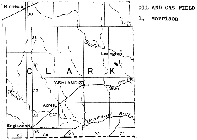
Gas was first discovered in a well drilled to a depth of 4,450 feet in sec. 21, T. 32 S., R. 21 W., in November, 1928. This gas well had an estimated capacity of 20,000,000 cubic feet open flow. The discovery oil well was drilled in sec. 17 of the same township in November, 1936. The oil is believed to occur in the Viola "lime" and the well produces from a depth of 6,477 to 6,481 feet. At the present time there are but two oil wells in this pool, which has been named the Morrison. The discovery well produced at the rate of 2,358 barrels a day on potential test, and is the deepest producing well in Kansas.
The discovery of oil in Clark County led to an intensive leasing campaign over practically the entire county, and in adjacent parts of Ford, Kiowa, and Comanche Counties.
The bed-rock formations lying at and near the surface in Clark County consist of Permian red beds and similar formations in which the water is strongly mineralized. However, in many places in the southern half of the county the bed-rock formations are overlain by thick deposits of valley alluvium, dune sand, and Quaternary terrace sands and gravels (flood plains of older streams) in which usable water can be obtained in shallow wells. The northern edge of the county is veneered by the Ogallala formation of Tertiary age, in which sheet water occurs.
A bed of volcanic ash is exposed in the southeast corner of sec. 23, T. 30 S., R. 24 W. This bed contains about 10 feet of ash, but apparently is of very small areal extent. Another deposit has been reported in sec. 12, T. 30 S., R. 23 W. There has been little or no exploitation of these deposits.
According to available well records, salt underlies the entire county, ranging from a thickness of about 100 feet in the southeast corner to about 500 feet near the northwest corner.
Sand and gravel occur in potentially commercial deposits in northeastern, southeastern, and west central Clark County. These sediments lie in stream alluvium and terrace deposits.
Western Clay County is crossed from north to south by the Dakota sandstone, and central and eastern Clay County by shales and limestones (including the Herington) of Lower Permian age. The county quarried both sandstone and limestone during 1935 for use as road material and in concrete. Stone quarry sites are abundant across the southern half of the county and in the northeast corner.
Clay County is crossed from northwest to southeast ~the Republican River. Sand and gravel are available both in the flood plain and in the stream bed. Two operators reported sand and gravel production near Clay Center during 1935 for use in paving.
An abundant supply of ground water is obtainable along the flood plain of the Republican River by shallow wells penetrating streaks of coarser water-bearing sediment in the valley fill. Bed rock supplies can be obtained from the Dakota sandstone in western Clay County, but in the eastern part of the county the water in the bed rock is generally mineralized.
A 20-barrel oil well was completed In sec. 21, T. 9 S., R. 4 E., in December, 1928. Oil was struck at a depth of about 1,770 feet. This one-well field (now abandoned) was named the Wakefield pool. Two dry holes were drilled in the same section in 1934 and 1935. One well was abandoned at 1,781 feet, the other at a depth of 1,879 feet. Another well was drilled in section 4, T. 10 S., R. 4 E. in 1935. This well was abandoned as a dry hole at a depth of 1,834 feet.
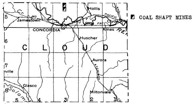
Coal occurs in Cloud County in the Dakota formation of Cretaceous age. This coal is much younger than that mined in eastern Kansas. It is black lignite, and occurs in a 2-foot bed which has within it a 4-inch parting of impure coal. The production of coal in Cloud County commenced in 1855 and has been carried on intermittently and on a small scale ever since. Two shaft mines are located about 6 miles north of Concordia. One of these operated during 1936, producing 670 tons of coal.
All of Cloud County except the uplands near the western end of the county is floored with Dakota sandstone and shale. The western end of the county contains the overlying Graneros and Greenhorn formations, including several relatively thin limestone beds such as the "Fencepost" limestone or "post rock". Several thousand tons of limestone were quarried in southwestern Cloud County during 1935 for use in road material and concrete aggregate. Dakota sandstone has been quarried in the past and used locally as building stone.
Sand and gravel for paving and structural purposes are obtained in Cloud County from the alluvium of the Republican River near Concordia. Terrace deposits have been extensively exploited in southwestern Cloud County both north and south of the Solomon river near Glasco. These sands and gravels were deposited by the Solomon river many years ago when it occupied a different and higher channel.
Abundant supplies of water are available in central and eastern Cloud County by means of shallow wells dug or drilled into the outcropping Dakota formation, or into valley fill. However, wells drilled to the Dakota sandstone in western Cloud County, where this formation is covered by the overlying Graneros and Greenhorn formations, have encountered salt water in many instances. Local supplies are available throughout most of this upland area by shallow wells into the soil veneer, and in some cases into the bed rock in which water is stored in crevices.
Cloud County has not been adequately tested for oil and gas. No deep tests have been drilled in recent years. Only one well has penetrated the pre-Pennsylvanian rocks for any great distance. This was the Murdock well in section 6, T. 6 S., R. 4 W. It was abandoned at a total depth of 3595 feet.
A brick plant operated at Concordia at one time.
Coffey County produced 28,821 barrels of oil in 1936. The fields are extensions of the Greenwood and Woodson County districts into the southern and southwestern parts of Coffey County. Production is obtained, as a general rule, at depths between 1,500 and 2,000 feet. The southwestern Coffey County fields, including the Van Noy and Carter, and fields along the Greenwood and Woodson County lines, produce from the "Mississippi lime". The LeRoy field in southeastern Coffey County produces from sandstones in the Lower Pennsylvanian. Attempts to find oil or gas production farther north in Coffey County have as yet been unsuccessful.
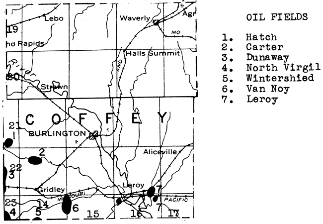
Coal is mined in northwestern Coffey County from the upper part of the Severy shale. This is the highest Pennsylvanian coal mined in Kansas. It lies about 2,000 feet stratigraphically above the Cherokee coal that is mined in southeastern Kansas. The Coffey County district is a southwestward continuation of the coal fields of Osage County. During 1936, four mines were in operation near Lebo in Coffey County, producing 1245 tons of coal. Two of these mines are shaft mines and the other two strip mines.
The principal source of water in Coffey County is the Neosho River, which crosses the county from northwest to southeast. The flow of this stream is sufficient to furnish adequate municipal and industrial supplies. The deeper bed rock water supply is mineralized in most parts of the county.
Coffey County is crossed from northeast to southwest by a series of fairly thick limestones which are quarried when needed. Quarry sites are found in northern, central, and south-central Coffey County. Deposits of high terrace flint gravels of commercial value have been found in the uplands in northwestern and southern Coffey County.
Northern and north-central Comanche County is veneered with the Ogallala formation of Tertiary age in which abundant supplies of water are available for domestic, farm, and municipal use. The valleys of Cimarron river and its tributaries in western and southwestern Comanche County are filled with river alluvium, dune sand, and terrace deposits in which water is available at shallow depths.
Comanche County lies between Clark County, with its recently discovered Morrison oil and gas field, and Barber County with three oil and gas fields. The Clark County discovery late in 1936 caused considerable leasing activity in western Comanche County. So far no deep tests have been drilled in this county.
The gypsum beds which are quarried at Sun City in northwestern Barber County extend about 12 miles up the valley of Salt Fork Creek into southeastern Comanche County. Gypsum has not as yet been exploited in Comanche County, but a fairly large tonnage is apparently available.
At least two deposits of volcanic ash occur in Comanche County. One of these is about 1 mile north of Wilmore and the other about 5 miles south of the same town. A small amount of material has been removed from these deposits and used in the construction of U. S. Highway 160.
Several sand and gravel depoSits with commercial possibilities occur in the Tertiary area of northern Comanche County.
One or more oil and gas fields have been found in almost every township in Cowley County. The greatest concentration, however, occurs in the northwestern half of the county, where such large fields as the Rainbow Bend, Winfield, State, and Weathered occur. Producing horizons include a shallow gas sand in the uppermost Pennsylvanian rocks, formations in the. Shawnee group at depths in the neighborhood of 1,500 feet, formations in the Kansas City group at depths ranging from 1,900 feet in the eastern part of the county to 2,500 feet near Winfield, the Bartlesville sand, which produces oil in the Rainbow Bend and other prolific western Cowley County fields at depths in the neighborhood of 3,000 feet, and the Ordovician "Siliceous lime" which lies at a depth of about 3,500 feet where productive in western Cowley County. A relatively small amount of oil is obtained from the "Mississippi lime" in eastern and southern Cowley County.
Oil production in this county reached a peak of nearly 4,000,000 barrels in 1926 when the Rainbow Bend field, discovered toward the close of 1923, was at the height of its development. Subsequently, production fell off to a low point in 1934 of 1,680,934 barrels. New discoveries in the county boosted the yield in 1936 to 1,804,114 barrels.
The Dexter gas field, in southeast-central Cowley County, was the scene of the discovery in 1908 of the first helium to be found in natural gas, from a well drilled in 1906. This gas runs about 2 per cent helium, with the balance mainly nitrogen. It is non-inflammable. A plant was constructed in 1927 to extract helium. It has been intermittently in operation since that time.
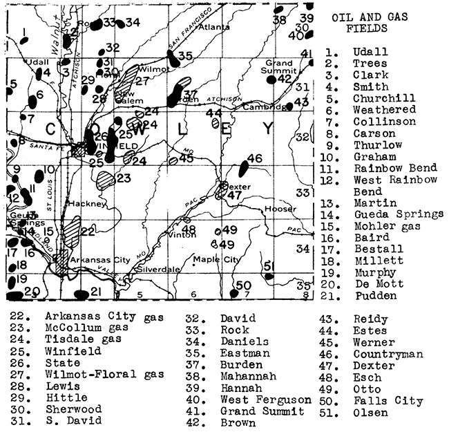
Several thick beds of limestone cross Cowley County from north to south. The most important of these from an economic standpoint is the Fort Riley. This stone has been quarried for many years near Silverdale and is commonly marketed as "Silverdale stone". The Fort Riley limestone has also been quarried in the vicinity of Winfield and south and southeast of Arkansas City.
The Silverdale quarry is one of the very few places in the state reporting production of building stone during 1935. Rubble was also marketed. The Cowley County Highway Department during the same year quarried several thousand tons of limestone for use in road metal and concrete.
Sand and gravel are dredged from the bed of the Kansas River immediately west of Arkansas City. During 1935 paving and structural sand and gravel and engine sand were produced. A very large deposit of terrace gravel near Silverdale has been extensively exploited in past years.
Cowley County is drained by the Arkansas river and two large tributaries, Walnut river and Grouse creek. The cities of Winfield and Arkansas City obtain municipal supplies from shallow wells drilled into pervious sand bodies in the fill of Arkansas river valley. The refineries in Arkansas City obtain industrial water from the same source. Smaller supplies are available in parts of the upland areas in crevices in the bedrock limestone formations.
High quality rock wool has been blown from samples collected at the rock quarry at Silverdale (utilizing much of the waste rock at that quarry) and from two localities in the vicinity of Winfield.
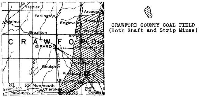
The greatest mineral resource in Crawford County is coal, and Crawford produces more coal than all of the other counties combined. During 1936, 24 strip mines were in operation, producing 1,639,547 tons of coal. During the same period 53 shaft mines in the county produced 653,488 tons of coal. The total for the county was 2,293,035 tons, and the state total in 1936 was 3,147,225 tons.
The following remarks on the coal industry of southeastern Kansas were kindly prepared by C. Y. Thomas, Chief Engineer, The Pittsburg and Midway Coal Mining Co., at the request of the State Planning Board.
"Coal produced within the state has been and is an important economic factor in settling and industrial development of the state of Kansas. All of the state's coal is bituminous in character and is produced in Leavenworth, Franklin, Osage, Labette, Linn and principally in Cherokee and Crawford counties. With the exception of the well known Cherokee coal which is mined in the latter two counties, the distribution and use of the coal is almost entirely in local communities.
"The Cherokee coal deposits, so called because of being found in the Cherokee shales, are well known; this coal being shipped to portions of Oklahoma, Kansas, Missouri, Iowa, Nebraska and South Dakota.
"The Cherokee coal field is an elliptical shaped area, approximately 32 miles long and from 3 to 12 miles wide extending from the southwest to the northeast though Cherokee and Crawford Counties and into Barton County, Missouri, The formation in this area dips away from the Ozark up-lift at the rate of 22 feet per mile to the northwest. The regional dip is very uniform, characteristic of the simple geology of this portion of Kansas.
"Because of the level terrain and the uniform dip of the coal seams, this field has witnessed the development of the world's foremost and economical stripping mines. Because of stripping methods, three distinct coal seams are being mined regularly and two others occasionally, four of these seams being too thin to be mined by any other than stripping methods.
"The most important coal seam is the Weir-Pittsburg which has an average thickness of 36". The other important seams are the Lightning Creek or Mineral seam which is 22" thick and the Limestone or Pioneer seam which is 18" thick. The other seams which are of almost negligible importance are 12" or 14" in thickness.
"Records indicate that Kansas mines have produced, up to 1937, almost 227,000,000 tons of coal. In the most important Southeast Kansas or Cherokee field, the reserves or coal yet to be mined are closely estimated at 175,000,000 tons of which 100,000,000 tons is stripping reserve and 75,000,000 tons shaft coal reserve.
"Extremely low prices of fuel oil and natural gas have reduced the Kansas coal production to about half that of the 1920's or about 3,000,000 tons per year. There was, however, an increase in production in 1936 as compared to a few previous years.
"Kansas coal, while generally considered as an excellent industrial or steam coal, is widely used as domestic fuel. Its popularity and use has been extended through the installation of modern preparation facilities. Practically all mines are equipped with adequate shaking screens which are used to separate the mine run coal into as many as eight or ten different sizes. After sizing, the coal is carefully hand picked for the removal of impurities and is gently lowered into railroad cars by loading booms.
"From the consumer's standpoint the most significant development in the Kansas field has been the installation of mechanical cleaning plants. Because of the difference in specific gravity or weights of the same size pieces, coal being much lighter than rock, shale and dirt, the coal is literally floated, the clean coal being skimmed off the top while the heavy refuse is drawn off at the bottom of the cleaning unit. Mechanically cleaned Kansas coal has been on the market since 1931 and has been established as a premium coal.
"Southeast Kansas coal has a higher heating value per pound than any of the high volatile bituminous coals of Missouri, Illinois, Iowa, Oklahoma or Colorado, either in the raw or mechanically cleaned states, and is the basis of comparison in the Missouri Valley for other similar coals.
"More money has been expended for the installation of new equipment and the modernization of old equipment in the seven years since 1929 than in the previous 15 years. It is known that almost $1,500,000.00 in new equipment has been ordered and will be placed in operation in the Southeast Kansas field before the fall months of 1937.
"Labor conditions in the coal field have been most favorable for a number of years.
"Adequate reserves of good coal, favorable labor conditions and many modern coal mines and preparation plants assure Kansas and the Missouri Valley of a plentiful supply of good coal for many years to come.
"The most interesting innovation in the Southeast Kansas field has been the construction and by now almost a year's operation of a plant to concentrate iron sulphide out of the coal mine refuse. Coal "brasses", which are removed by either hand picking or mechanically cleaning methods, are treated to make a very high grade concentrate of iron sulphide, generally known as pyrite. The concentrated pyrite is being shipped to St. Louis where in a roasting process, sulphuric acid is made. After the sulphur has been roasted out of the pyrite, the resultant iron oxide is sold for use as paint pigment, blast furnace charge or as a medium to make heavy density solutions. The complete plant is the only one of its kind in the world."
The Cherokee shale which lies at the surface in southeastern Crawford County contains, beside valuable beds of coal, beds of clay which have been exploited in the Pittsburg area for many years. As many as five plants have been in operation in Pittsburg at one time producing brick, stoneware, pottery, and other ceramic products.
The Cherokee shale outcrop is succeeded to the northwestward in Crawford County by outcrops of younger limestones, including the commercially important Fort Scott, Pawnee, Altamont, and Bethany Falls formations. Limestone was quarried in the northern part of this county during 1935 for use in road metal and concrete.
The deep bed-rock formations that produce municipal and industrial water supplies in Missouri extend across the line into Crawford County, and are the sources of potable water at Pittsburg, Frontenac, and Girard. Unfortunately, farther to the west and north, these water-bearing formations lie at greater depthS and are too highly mineralized for use.
Several small oil and gas fields occur near the western boundary of Crawford County. One field, the Walnut-Hepler, lies partly in southwestern Bourbon County and partly in northwestern Crawford County. Smaller fields have been developed in the vicinity of Walnut, a few miles to the south. The oil and gas occur in a sand which lies at a depth of about 600 feet. Southwestern Crawford County contains the McCune field, a relatively new discovery. Here oil lies at even more shallow depths, some producing wells having encountered the pay horizon at about 300 feet.
The greatest natural resource of Decatur Count;y so far discovered is underground water. Almost the entire county is floored with the Ogallala formation of Tertiary age, and sheet water is available within this formation at relatively shallow depths over a large part of the county. A beginning has been made in using this water for irrigation.
Volcanic ash has been reported from two localities in this county. In at least one of these deposits the ash is of Tertiary age, and lies beneath mortar beds. Consequently it cannot be mined as cheaply as the ash which lies at the surface to the east in Norton County.
An oil test is now being drilled in Decatur County in sec. 34, T. 2 S., R. 28 W. A dry hole was completed in sec. 26, T. 3 S. R. 26 W. in March, 1937. This well encountered the top of the "Siliceous lime" at a depth of 4,080 feet, hit pre-Cambrian quartzite at 4,128 feet and was abandoned at a total depth of 4,149 feet. Three or four other wildcat tests have been drilled in the county. However, this part of the state has not been sufficiently tested to reach any conclusion as to the presence of oil in the deeper formations.
Commercially exploitable deposits of sand and gravel are common in central and southern Decatur County. These originate through the reworking of Tertiary sediments by recent streams. Tertiary "mortar beds" are also available in this county.
A stone quarry site has been found just north of Oberlin.
Smoky Hill River crosses Dickinson County from west to east, and the municipalities along its valley obtain water from shallow wells into the valley fill. The city of Herington, near the southeastern corner of the county. uses impounded surface water for municipal supply. In the upland areas most of the water is obtained from either surface run off or from gravel beds in the tributary stream valleys. Bed-rock water in the western part of the county is so contaminated with gypsum that it is excessively hard.
Dickinson County is crossed from southwest to northeast by a narrow and elongate anticline, known to petroleum geologists as the "Abilene arch". The Ritz-Canton field to the southwest in McPherson County lies on the axis of this anticline. The Lost Springs field of northeastern Marion County almost reaches the county line in the southeastern corner of Dickinson County. Attempts to extend this field into Dickinson County and to find production along the "Abilene arch" have so far been unsuccessful, although several wells reported fairly good shows of oil. One well, completed in January, 1932. in sec. 13. T. 13 S., R. 2 E., about 2 miles east of the town of Abilene, is reported to have been drilled in "Siliceous lime" from 3,060 feet to 4900 feet total depth, an unusual thickness for this formation in Kansas. A dry hole was completed during March, 1936, in sec. 15. T. 15 S., R. 1 E. This well reached a total depth of 3549 feet.
Gypsum occurs in southern and western Dickinson County in two beds. the upper one about 5 feet thick and the lower one reported to be 14 feet thick. This gypsum was exploited at one time at Hope and Solomon, but no production has been reported from this district for many years.
Two sand and gravel deposits have been found in southeastern Dickinson County near Herington.
Doniphan County lies in the very northeastern corner of the state. It is bordered on the east by the Missouri River. Bed-rock formations are well exposed along the eastern edge of the county in the ravines carved by tributaries of the Missouri. The uplands to the west, however, are veneered with glacial deposits. A large tonnage of limestone was quarried during 1935 in eastern Doniphan County, mainly for use as riprap along the Missouri River. A relatively small amount was used for road metal and concrete. A few thousand tons of sandstone were likewise quarried in this county during 1935 for highway use.
The valleys of Doniphan County are floored with alluvium consisting in the main of reworked glacial materials which are sufficiently coarse in many places to contain an adequate supply of water for local use. Some farm supplies are obtained from pervious layers in the glacial drift.
Six tests for oil and gas have been drilled in Doniphan County. Four of these did not penetrate below the Cherokee shale, one went through the "Mississippi lime", and one, in sec. 21, T. 1 S., R. 19 E., went into Siluro-Devonian formations at a depth of 2,281 to 2,315 feet, total depth., Doniphan County lies on the east flank of a large syncline known as the Forest City Basin. This part of Kansas has not yet been adequately tested for oil and gas.
Volcanic ash has been reported from Eagle Springs near Sparks, in the northern part of the county. No information is available as to the size of this deposit.
Sand and gravel deposits occur in the southwestern part of the county, and along the eastern edge in the bed of the Missouri river.
Both oil and gas have been found in southeastern Douglas County in the vicinity of Baldwin. The most important of these occurrences is the Baldwin pool, which lies in T. 15 S., R. 20 E. The discovery well of this pool was completed in 1919. The oil is relatively heavy and occurs at a depth Of about 800 feet. Due to the development of this field, Douglas County had a maximum oil production of 23,901 barrels in 1927. The yield fell off to less than 7,000 barrels the next year, and since 1932 Douglas County has not been included in tabulations of the oil-producing counties of Kansas.
A half dozen successful gas wells have been drilled near Eudora, in eastern Douglas County. Both the oil and gas produced in Douglas County come from sands occurring in either the Marmaton group or the Cherokee shale of Lower Pennsylvanian age. Only one deep test has been drilled in the county, in sec. 28, T. 12 S., R. 19 E. This well drilled 227 feet into the "Siliceous lime" between 2,155 and 2,382 feet, total depth.
Thin beds of coal occur in the Tonganoxie member of the Stranger formation. This coal has been intermittently mined in the Blue Mound area for many years. One small mine was in operation during part of 1935.
Central and western Douglas County is crossed from north to south by the Oread and Lecompton limestones. Limestone was quarried during 1935 for use in road metal and concrete. Quarries and quarry sites occur at Lecompton, west of Lawrence, and in the hills south of Wakarusa Creek in the southwestern part of the county.
Two dredges obtain sand and some gravel from the bed of Kansas river at Lawrence. This sand is marketed mainly for structural purposes, but some is sold as molding sand, glass sand, and engine sand.
There are three principal sources of water in Douglas County, surface, valley fill, and bed rock sandstones. The Kansas River supplies water to the city of Lawrence. The flood plain of Kansas River lies along the north side of the county. It contains widespread beds of permeable sediments, so it is very exceptional when a well drilled on the valley floor fails to encounter sheet water. Somewhat the same conditions prevail in the flood plain of Wakarusa Creek, which crosses the central part of the county from west to east. Douglas County is underlain by the Ireland and Stranger sandstones, which have been penetrated by some very good wells in the eastern part of the county, including those supplying the city of Baldwin. However, in central and western Douglas County the water in these sandstones is too highly mineralized to use.
At one time a brick plant operated in Lawrence, making red brick from the Lawrence shale.
At the present time Edwards County contains one oil and gas pool, the McCarty, 12 miles south of Kinsley in T. 25 S., R. 17 W. This field was discovered in 1929, and produced 27,854 barrels in 1935 and 3,403 barrels in 1936 (intermittent production). The producing formation is the Mississippian "chat" at a depth of 4,575 feet. An 18,000,000 cubic foot gas well, 1 3/4 miles northeast of the discovery oil well, may occupy a separate structure. The oil field is dormant at the present time due to lack of pipe-line outlet. However, both eastern and western Edwards County were scenes of active leasing during 1936. A well is now drilling in section 18, T. 24 S., R. 19 W. Dry holes were completed in January, 1934, in section 1, T. 24 S., R. 16 W., at a depth of 4500 feet, and in February, 1937, in section 14, T. 26 S., R. 18 W., with a total depth of 4984 feet. A well completed in November, 1932, in section 30, T. 24 S., R. 18 W. at a total depth of 5319 feet encountered the "Oswald lime" at 3995 feet, the Mississippian at 4595 feet, and the "Siliceous lime" at 4968 feet. Oil shows were found at 4552, 4565, and 4573 feet.
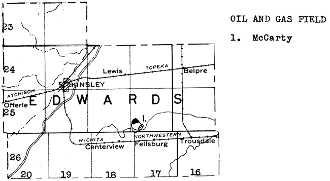
Western Edwards County is crossed by Arkansas River from the flood plain of which abundant supplies of water are available. The remainder of the county is covered by old river deposits and sand dunes in which sheet water is present at fairly shallow depths.
Sand and gravel occur near Kinsley and elsewhere along the Arkansas River.
Elk County has been a producer of oil and gas since 1902, but the greatest development took place shortly after 1924. The county reached a production peak in 192? with nearly 900,000 barrels of oil. During 1935 the production was 5801556 barrels. The greatest. concentration of oil and gas fields is in the southern and western half of the county. Southeastern Elk County contains the Longton field, which extends southward into northeastern Chautauqua County. This field overlies an elongate north-south anticline. It was discovered in 1915, but was not actively developed until some years later when a 10,000,000-foot gas well was drilled. The gas comes from within the "Mississippi lime" at depths ranging from 1,540 to 1,690 feet. Other important oil and gas fields in Elk County. include the Webb, Moline, Ferguson, and Bush-Denton. As a general rule the fields in the eastern part of the county produce from the "Mississippi lime", while those in the western part of the county obtain production from a half dozen sandstones in the Kansas City and Marmaton groups and in the Cherokee shale. Accumulation is due to the presence of anticlinal structures and not to "Shoe-string" sand bodies.
Two fields in Elk County have recently drilled into the "Siliceous lime" with very successful results. One is the Key Pool, which lies in secs. 25 and 26. T. 31 S., R. 10 E., and the other is the Shambough pool in the northwestern corner of the county. In February, 1937, three wells in the Key pool were producing from depths of about 2,280 feet. The three wells had an estimated potential of about 5,500 barrels a day. The Shambough pool was likewise discovered in 1936 and had four producers in February, 1937. The "Siliceous lime" occurs at a depth of about 2,900 feet in this part of the county.
Elk County is crossed from north to south by a series of thick limestone beds, including those belonging to the Deer Creek formation. One of the largest quarries in the state, east of Moline, mines rock from the upper part of the Deer Creek formation. The rock from this quarry is used for road metal and concrete, railroad ballast, and to a relatively minor extent for agricultural purposes.
It has been necessary in Elk County to use surface waters for municipal and industrial supplies. Although water is abundant in some of the deeper bed-rock formations. it is too highly mineralized for use.
A very excellent quality rock wool was blown from samples collected in the quarry of the Solvay Process Company at Moline.
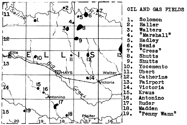
Ellis County did not have a producing oil or gas well 10 years ago. Now it has sixteen fields and is one of the "hottest' parts of the state in regard to oil and gas development. Most of these pools are very recent discoveries. The production of oil for the county in 1935 was 166,814 barrels and in 1936 it rose to 758,152 barrels. These pools are prorated and the potential production is very much greater than the actual production.
A tabulation of Ellis County pools follows:
| Name of pool | Discovery date |
Producing formation | Depth |
|---|---|---|---|
| Antonio | 1936 | Basal Paleozoic sand | 3,700 ft. |
| Bemis | 1935 | Topeka "lime" | 3,030 ft. |
| "Siliceous lime" | 3,350-3,450 ft. | ||
| Catherine | 1936 | "Oswald" formation | 3,272 ft. |
| Badley | 1929 | Basal Pennsylvanian conglomerate |
3,435 ft. |
| "Siliceous lime" | 3,630 ft. | ||
| Baller | 1936 | Topeka "lime" | 3,040 ft. |
| Kraus | 1936 | Basal Paleozoic sand | 3,735 ft. |
| Madden | 1936 | "Siliceous lime" | 3,590 ft. |
| Marshall | 1936 | "Siliceous lime" | 3,650 ft. |
| Penny Wann | 1936 | "Siliceous lime" | 3,636 ft. |
| Ruder | 1935 | Kansas City "lime" | 3,425 ft. |
| "Siliceous lime" | 3,575 ft. | ||
| Shutts | 1928 | Kansas City "lime" | 3,225 ft. |
| Siliceous lime" | 3,575 ft. | ||
| Solomon | 1936 | "Siliceous lime" | 3,630 ft. |
| Ubert | 1936 | "Siliceous lime" | 3,615 ft. |
| Victoria | 1935 | Kansas City "lime" | 3,300 ft. |
| "Siliceous lime" | 3,550 ft. | ||
| Walters | 1936 | Topeka "lime" | 3,100 ft. |
| "Siliceous lime" | 3,615 ft. | ||
| Yocemento | 1929 | Kansas City "lime" | 3,590 ft. |
| "Siliceous lime" | 3,600 ft. |
The location of these fields is shown on the accompanying map. Ellis County was very extensively leased by the close of 1936.
Ellis County is floored mainly with chalk, shale, and thin limestone beds of Cretaceous age. These are not water bearing as a general rule. Some water is obtained in the upland areas in the western part of the county from the Cadell sandstone immediately beneath the Niobrara chalk. Municipal supplies in this county are obtained from shallow wells in the flood plains of Smoky Hill River and its tributaries. The Dakota is relatively deep and yields highly mineralized water in many parts of the county.
The massive chalk beds that lie in the lower part of the Niobrara formation are exposed in the valley of Smoky Hill River west of Hays. At one time a cement plant was in operation at Yocemento, but it has been abandoned and dismantled for many years. The commercial possibilities of this chalk is to be a subject of investigation by the State Geological Survey of Kansas during the coming year.
A very fine white rock wool was blown from samples collected in the Yocemento quarry.
Sand and gravel deposits occur in northern and western Ellis County along Saline River, Big Creek, and Smoky Hill River.
The discovery oil well of Ellsworth County was completed in October, 1930. Now there are eight oil fields in the county. These are all in the southern and southwestern part, and their names and locations are given on the accompanying map. Each of these fields produces from the "Siliceous lime" at depths ranging from 3,200 to 3,300 feet. In addition the Breford and Lorraine pools produce from the Kansas City formation. The production for the county during 1936 was 3,014,106 barrels.
Ellsworth County has in addition two gas fields, the Satran and the Ellsworth. The latter was discovered in about 1904 and produced for several years before being abandoned. The Satran gas field lies in secs. 5 and 6, T. 14 S., R. 9 W. It was discovered in 1931. The producing sand occurs at a depth of a little less than 1,400 feet.
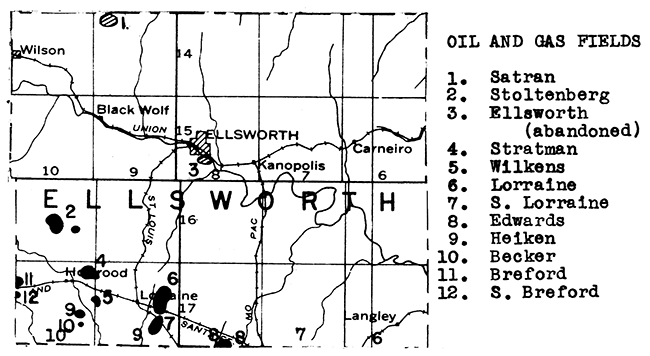
Two mines at Kanopolis in Ellsworth County produced many thousands of tons of rock salt during 1935. The salt lies at a depth of about 860 feet. It is a part of the great salt body that underlies central and southwestern Kansas.
At least two deposits of volcanic ash occur in Ellsworth County. These lie east and southeast of Kanopolis. The statistics of the U. S. Bureau of Mines for 1935 report a small shipment of ash from Wilson, near the northwestern corner of the county.
All of Ellsworth County, except the uplands in the southwestern and northwestern parts, is floored with Dakota sandstone. Industrial and municipal supplies of water can be obtained in the Dakota sandstone by means of relatively shallow wells.
Sand and gravel deposits are abundant along Smoky Hill valley from near the northwestern corner of the county to the southeastern corner.
Gas was discovered in a well drilled in sec. 16, T. 25 S., R. 34 W. at the close of 1932. This one-well field has been named the Holcomb. Subsequently gas wells have been drilled in the next townships to north and south (see map) and to the west and southwest in Kearny County. In all probability, these wells lie in the great Hugoton gas field which extends from south of the Kansas-Oklahoma line northward across parts of Stevens, Seward, Haskell, and Grant counties, into Kearny and Finney counties.
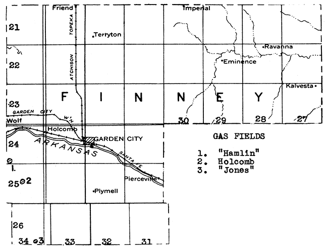
The Shallow Water oil field of southern Scott County is but 3 miles north of the Finney County line. Another field, the Aldrich, in western Ness County lies about 18 miles northeast of the northeastern corner of Finney County. Finney County has not yet been adequately tested for oil possibilities.
Finney County is very well supplied with water. Most of the county north of the river is floored by the Ogallala formation of Tertiary age in which sheet water occurs. This is especially true in northwestern Finney County, which lies in the southern extension of the Shallow Water Basin of Scott County. Water is obtainable in this basin at depths of 20 to 75 feet. It is pumped and used for irrigation. Southern Finney County is crossed by the flood plain of Arkansas River, and covered with dune sand south of the flood plain. An abundant supply of water is available at shallow depth in the flood plain of Arkansas River and in the sand dune area.
Sand and gravel deposits are abundant along Arkansas River, and along tributaries of Pawnee River in the northeastern part of the county.
Sand and gravel deposits are abundant in the Arkansas River both in the present stream bed and in low terraces which are remnants of an older flood plain. Sand and gravel deposits also occur within the Ogallala formation, especially along the northern edge of T. 27 S., R. 25 W., and near the center of T. 25 S., R. 23 W. One operator in Ford County reported production during 1935 of several thousand tons of paving sand, structural sand, and lesser amounts of engine sand and sand used for miscellaneous purposes.
Ground water is available over most of Ford County. Towns along the Arkansas River can obtain shallow water by wells into the valley fill. To the north and south of the flood plain the uplands are capped with the Ogallala formation of Tertiary age in which sheet water is obtainable at moderate depths as a general rule.
Ford County has not yet been adequately tested for oil and gas. It overlies what is known as the Dodge City Basin, and the same formations that are productive in counties to the east are buried to much greater depths in Ford County. Two deep tests have been drilled in the county. One, in sec. 22, T. 29 S., R. 21 W., was completed as a dry hole at a depth of 6206 feet in October, 1931. This well reached the "Siliceous lime" after encountering the "Oswald lime" at 4748 feet and the top of the Mississippian at 5268 feet. The other test was completed 13 months later in sec. 21, T. 25 S., R. 24 W. The "Oswald" was penetrated at 4220 feet, the Mississippian at 4890 feet, and the ordovician at 5480 feet. The well was abandoned at 5782 feet in the "Siliceous lime". Shows of oil or gas were encountered at 1975, 3025, 4335, 4750, and 4895 feet. The recent discovery of oil in the Viola limestone at a depth of 6,400 feet in eastern Clark County has led to considerable leasing activity in southeastern Ford County.
Extremely fine white wool has been blown from Tertiary "mortar beds" collected 7 miles northeast of Dodge City. This formation proved to be a natural wool rock.
A study was made several years ago of the possibility of making sand-lime brick from the raw materials available in the Dodge City area. The ceramist consulted was of the opinion that such bricks could be successfully manufactured.
Franklin County has been producing relatively small amounts of oil and gas for a great many years. Most of the oil fields lie in the eastern half of the county in the vicinities of Rantoul, Peoria, and Wellsville. Farther to the west, in the vicinity of Ottawa, and in the northwestern part of the county between Pomona and Centropolis are several gas fields, some of relatively recent discovery and development.
The oil production of Franklin County has declined from a peak of 194,148 barrels of 1926 to 78,053 barrels in 1935.
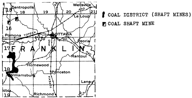
Coal with an average thickness of about 24 inches occurs in the Lawrence shale from 15 to 40 feet below the Oread limestone in southwestern Franklin County. It is mined in the vicinities of Williamsburg, Pomona, and Quenemo, and has been mined around Homewood and Ransomville. The depression caused an increase in mining in this district. During 1936 there were 14 shaft mines and one strip mine (which was abandoned in May) in operation in Franklin County, yielding a total production for the year of 22,010 tons.
Franklin County is crossed from northeast to southwest by a series of thick limestones, including especially the Stanton-Plattsburg. Two operators reported production of limestone in this county during 1935 for use in road metal and concrete. Quarries are located near Ottawa, and in the southwestern part of the county.
Central Franklin County is crossed from west to east by the Marais de Cygnes River. The city of Ottawa obtains its water from this stream. Except in the northeast corner of the county, bed-rock waters as a general rule are too highly mineralized for use. However, in the northeast corner the Ireland and Stranger sandstones yield the purest ground water to be found in the state. A shallow well into this formation supplies water to the city of Wellsville.
High terrace chert gravels in deposits thick enough to be exploitable cap the uplands in the west central part of Franklin County.
Kansas Geological Survey, Geology
Placed on web Jan. 28, 2016; originally published June 1, 1937.
Comments to webadmin@kgs.ku.edu
The URL for this page is http://www.kgs.ku.edu/Publications/Bulletins/MRC6/index.html