![]()
Prev Page--Start of Stratigraphy || Next Page--Petrology
Stratigraphy, continued
Geophysical well-log analyses
During the course of this study, geophysical well logs from 1,293 wells were examined. Of these, 1,231 penetrated at least a portion of the Banzet formation. The gamma-ray and neutron logs were found to be the most useful logs for determining the lithologies penetrated.
Spontaneous-potential/resistivity logs lacked the resolution shown by these radioactivity logs, and they also were affected by electrolytic contrasts between formation and drilling fluids. For these reasons, the gamma-ray log, supplemented by neutron and density logs, was used as the primary lithology indicator in wells without cores. Electrical logs were used only in the few wells where radioactivity logs were not made.
Comparisons with cored intervals
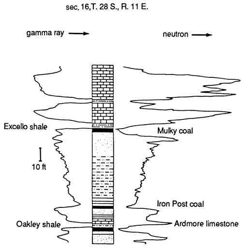
In each of the three areas where cores were available and in several other cores that I described in eastern Kansas, gamma-ray/neutron log signatures for repetitive rock sequences were consistent. Sandstone sequences and interstratified sandstone and mudstone sequences that were observed in cores form four distinctive gamma-ray log signatures. Fining-upwards sandstones with sharp bases are characterized by a gamma-ray signature that is bell-shaped (fig. 25A). Thinly interbedded sandstone and shale sequences are represented by a serrate to cylinder-shaped gamma-ray log signature (fig. 25B). Thin, calcite-cemented sandstones show low gamma-count spikes (fig. 25C), which are accompanied by symmetrical spikes on neutron and density log curves. Coarsening-upward sandstone sequences with gradational bases have funnel-shaped gamma-ray log signatures with serrated lower portions, which represent shale interbeds and abrupt upper boundaries (fig. 25D). Coal beds that are in excess of 0.6 m (2 ft) are represented by low gamma-ray spikes resembling those formed by sandstone and thin carbonate units. However, coal beds are represented on neutron and density logs by low neutron-density spikes that mimic rather than mirror the gamma-ray spike. Black, phosphatic clay shales are represented by extremely high gamma-ray spikes and accompanying low neutron spikes (fig. 26). This signature is so distinctive and the gamma-ray counts are so high that these black shales can be readily identified even where the unit thickness drops slightly below the resolution limit of about 0.6 m (2 ft).
Figure 25--Characteristic gamma-ray log patterns and their lithologic interpretations: A) bell-shaped pattern formed by a fining-upward sequence of sandstone to shale lying with sharp contact over shale; B) serrate pattern formed by interstratified sandstone and shale; C) spiked pattern produced by thin, calcite-cemented sandstone beds; and D) funnel-shaped pattern formed by coarsening-upward shale to sandstone sequence with gradational base and sharp upper contact; from Lardner, 1984.
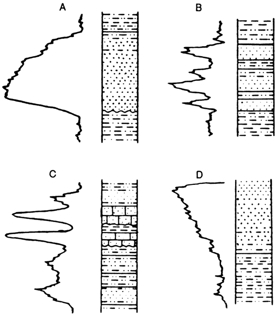
Figure 26--Gamma-ray and neutron-log signatures of black, phosphatic clay shales and other lithologies; modified from Denesen, 1985.
Sandstone determinations
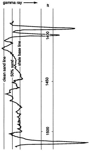
In order to map the distribution of sandstone bodies within the Banzet formation, the amount of sandstone had to be determined for each well. In uncored wells, this was accomplished by constructing shale-base lines, 100% sandstone lines, and a 50% sandstone line midway between the first two lines. The shale-base line was drawn at the gamma-ray values recorded by gray shales on each log. The 100% sandstone line was drawn at the lowest gamma-ray value produced by a known sandstone unit. All portions of the logged interval that had gamma-ray counts lower than the 50% sandstone line were counted as sandstones (fig. 27). Spontaneous-potential logs were handled in a similar way in wells that were not logged with a gamma-ray tool. On these logs, maximum SP deflection caused by a known sandstone was used as the 100% sandstone line and 0 deflection was used as the shale-base line.
Although using a 50% sandstone line as the maximum gamma-ray value for labeling an interval a sandstone may seem arbitrary, comparisons between logs and cores from the same wells indicate that this is a good approximation. I experimented with other sandstone-percentage lines and found that if lines closer to the shale-base line were used, then sandstone counts came out significantly higher than amounts measured in cores, while using lines closer to the clean-sandstone lines yielded sandstone counts that were too low. In addition, the 50% sandstone line is mechanically easy to establish, thus data generated in this fashion are more easily reproduced. To verify reproducibility, two operators (a student and I) independently determined sandstone thicknesses in randomly selected wells. Deviations were generally within the 0.3-m (1-ft) to 0.6-m (2-ft) range, which is minimal when one considers that the resolution of the logs is 0.6 m (2 ft) at best.
Figure 27--Illustration of method used to determine positions and thicknesses of sandstones within Banzet formation. Sandstone-unit contacts were placed where gamma-ray curve values dropped below the "50% sand" line. Intervals whose curves are to the left of this line were counted as sandstone. Same procedure was used with SP curves in wells that did not have gamma-ray logs available; modified from Lardner, 1984.
Distributions and log characteristics of rock units
Extent of black shale markers
The Excello shale, a black, phosphatic clay shale, overlies the Banzet formation. This shale was observed in all the gamma-ray logs and most of the SP logs that were studied. In addition, the Excello shale was either observed directly, or its float was dug out above Banzet outcrops in Kansas and Oklahoma. Studies done in Oklahoma (Krumme, 1981) and Iowa (Ravn and others, 1984) also show that the Excello shale is widespread over the entire region. This unit was deposited over the Banzet formation as a thin, continuous sheet.
Extent of the Verdigris Formation
The Ardmore limestone and Oakley shale members of the Verdigris Formation form a couplet that can be traced throughout the region. The Oakley shale can be observed on all gamma-ray logs that penetrate it, except where the Verdigris has been cut out by sandstone units at the base of the Banzet formation. The Ardmore limestone, which can be traced easily on the surface, is not as easy to trace in the subsurface using geophysical well logs. On the outcrop, this unit thins to a little over 1 m (3 ft) in Crawford County, Kansas. Conceivably, this limestone unit may drop below the limits of resolution in some of the wells that penetrate it. For this reason, the Ardmore limestone member of the Verdigris Formation was lumped with the Banzet formation in the construction of an isopach map. This allowed the isopach interval containing the Banzet formation to extend between two easily identifiable, widespread, black phosphatic clay-shale units.
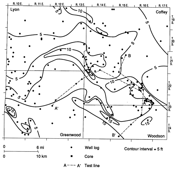
Extent of the Banzet-Ardmore interval
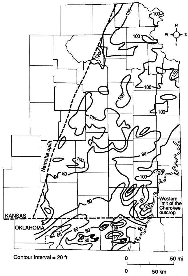
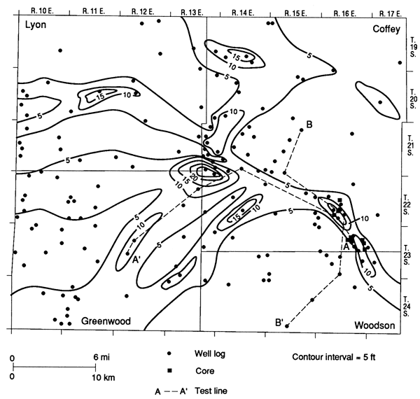
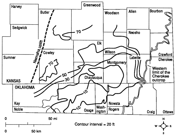
An isopach map constructed for the interval between the widespread Oakley and Excello shales shows a range of thicknesses from 9.1 m (30 ft) in the southwestern portion of the study area in Kay County, Oklahoma, to a thick of more than 60.7 m (199 ft) in sec. 34, T. 34 S., R. 17 E., Montgomery County, Kansas, where the base of a sandstone channel that cuts down through the Ardmore and underlying units is used as the interval base. However, most of the Kansas portion of the study area lies between 24.4 and 33.5 m (80 and 110 ft) (fig. 28). Although the interval thins to the southwest, thickness trends are not confined to the northeastern portion of die study area. In addition to a thick centered in Leavenworth County, lobate and linear thicks are found in Brown, Jackson, and Pottawatomie counties in the northwestern portion of the study area; Nowata County, Oklahoma, in the southeastern portion of the area; Lyon, Chase, and Coffey counties in the west-central portion of the area; and Crawford, Bourbon, Neosho, Labette, and northeastern Montgomery counties, Kansas, in the east-central portion of the study area (fig. 28). Each of these thicks is in excess of 30 m (100 ft).
Figure 28--Isopach map of Ardmore-Banzet interval (Banzet formation plus Ardmore Limestone Member of Verdigris Formation), consisting of strata between top of the Oakley Shale and base of the Excello shale.
Distribution and log characteristics of Banzet sandstone units
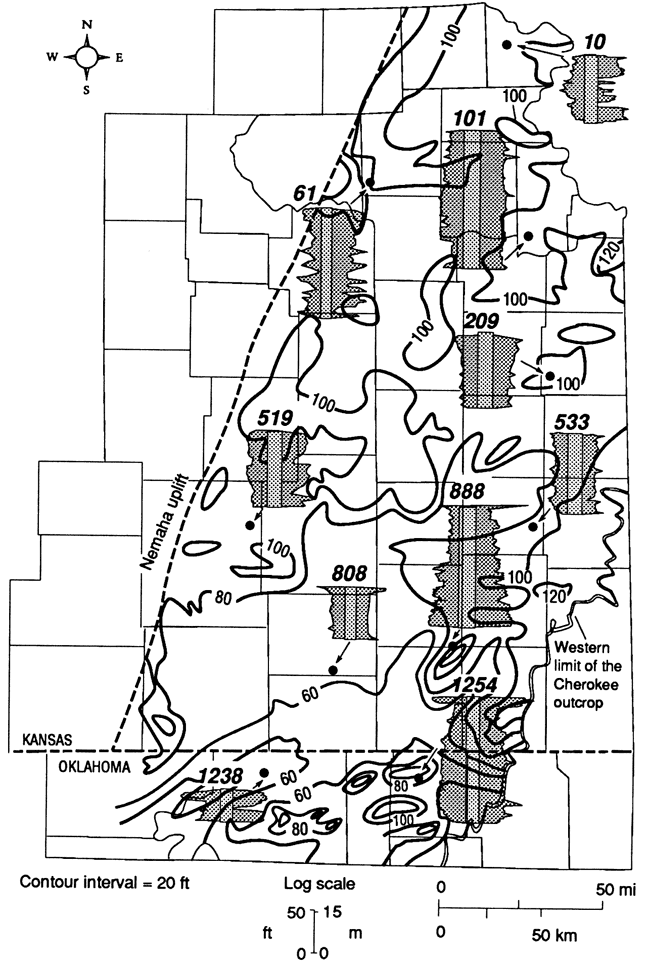
A gross sandstone-isolith map of the Banzet formation in the study area shows high sandstone patterns (fig. 29) corresponding to most of the thicks on the interval isopach map (fig. 28). This is to be expected because volume change in sand bodies due to compaction is much less than those in muds. Fig. 30 shows Ardmore-Banzet interval well-log signatures for various isopach thicks and thins. Some sandstone highs do not relate directly to isopach thicks. One such case is in northeastern Brown and western Doniphan counties, Kansas. The sandstone here seems to be part of a channel system that extends southwestward from southern Nebraska. The channels apparently cut out previously deposited muds, thus reducing the total sediment accumulation in this area.
Figure 29--Sandstone-isolith map of Banzet formation.
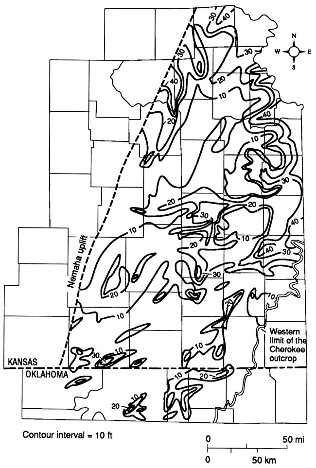
Figure 30--Typical Ardmore-Banzet well-log signatures that relate to isopach thicks and thins. SP and resistivity curves are shown for well 519, gamma-ray and density curves are shown for well 1238, gamma-ray and neutron curves are shown for all other wells. Well numbers relate to data listing in appendix A.
The sandstone isolith map for the Banzet shows a blurred picture of sandstone geometries because the sandstone bodies occur in several different horizons. Because no markers within the Banzet were observable throughout the study area, producing reliable isolith maps for stratigraphic portions of the formation was not possible. In local areas, however, sandstone isoliths were constructed for vertical subdivisions of the Banzet. These maps, along with cross sections, were useful for reconstructing the geologic history of the study area. In the following paragraphs, I will present these maps and discuss the nature of rock-body distributions in four portions in the study area.
Sandstones in northeastern Kansas--In northeastern Kansas, Nelson (1985) was able to divide the sandstone units of the Banzet formation into two genetically related sets. In the northern portion of his study area, all the gamma-ray/neutron well logs showed the presence of a coal near the middle of the formation. Well logs and cores south of a line through the northwest corner of Wyandotte County through Leavenworth, Jefferson, and Douglas counties and into the central portion of Shawnee County, do not contain this coal bed (fig. 31). Nelson (1985) suggests that the coal was removed by erosion as later channels cut into the subaerially exposed surface. As will be shown later, a regional analysis of coal beds and overlying transgressive lithologies supports his contention that the sandstone units in this area lie within an upper and lower portion of the Banzet, with the units within each being genetically related.
Figure 31--Sandstone-isolith map of lower portion of Banzet formation in northeastern Kansas; from Nelson, 1985.
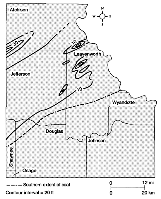
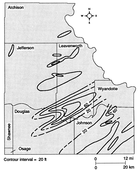
Fig. 31 is a sandstone-isolith map for the lower portion of the Banzet. It shows that discontinuous, lenticular sandstone thicks trend northeast-southwest. The thickest sandstone forms a lobate trend in the northwestern portion of the map area across the Atchison-Jefferson County border. The sandstone-isolith map for the upper interval shows similar trending thicks, with the thickest sandstones forming a lobate trend centered in the south-central portion of Leavenworth County (fig. 32).
Figure 32--Sandstone-isolith map of upper portion of Banzet formation in northeastern Kansas; from Nelson, 1985.
Two cross sections from Leavenworth and Douglas counties illustrate the spatial relationships between sandstone units in the Banzet formation in northeastern Kansas. Northwest to southeast, strike-oriented cross section A-A' (modification of Nelson's B-B') shows seven sandstone units at four different horizons (fig. 33). This section also shows the coal bed that was used to divide the Banzet into upper and lower portions. Two different types of sandstone body morphologies are shown on this cross section: 1) laterally continuous, thin, sheet-like bodies and 2) thick, laterally discontinuous bodies. The thick, laterally discontinuous sandstone bodies seem to truncate the underlying units. The well-log signatures of these units are bell shaped, indicating fining-upward sequences. The thin, more laterally continuous units have block, spike, or funnel-shaped signatures, indicating either thin, relatively clean sandstones, or coarsening-upward sequences.
Figure 33--Cross section A-A', strike-oriented view of Banzet sandstone bodies in northeastern Kansas. See fig. 6 for location; modified from Nelson, 1985.
Dip-oriented cross section B-B' (modification of Nelson's E-E') was constructed along one of the thicker northeast-southwest sandstone thicks (fig. 34). This section illustrates the laterally continuous nature of stacked sandstone bodies within lobate sandstone thicks. Signatures are bell shaped, funnel shaped, and blocky, with bell-shaped signatures being more prevalent towards the northeast. Bell-shaped and blocky signatures represent fining-upward sequences and well-sorted relatively coarse-grained units, respectively. Towards the southwest, the Banzet becomes increasingly shalier and thinner; well-log signatures of sandstone units between isolith thicks are more irregular, indicating interstratification of sandstone and shale.
Figure 34--Cross section B-B', dip-oriented view of Banzet sandstone bodies in northeastern Kansas. See fig. 6 for location; modified from Nelson, 1985.
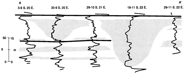
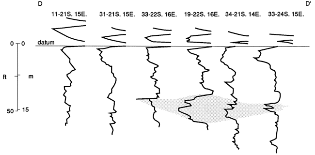
Sandstones in east-central Kansas--Lardner (1984) divided the Banzet into upper and lower sandstone-rich intervals. A sandstone-isolith map of the lower interval shows a lobate sandstone pattern which appears to radiate from an easterly source (fig. 35). The thickest sandstone concentration is in the center of the map area and seems to form a hub from which other sandstone trends radiate.
Figure 35--Sandstone-isolith map of lower portion of Banzet formation in east-central Kansas; from Lardner, 1984.
Cross section C-C' (modified from Lardner's A-A') shows an east-west section along the axis of a lower-interval sandstone trend (fig. 36). The lower sandstones are characterized by irregular signatures with sharp bases and gradational upper contacts. Cores of sandstone units in this interval verify that these signatures represent fining-upward sandstone to interstratified sandstone, siltstone, and shale, with a sharp, possibly erosional, basal contact over underlying shales and siltstones.
Figure 36--Cross section C-C', dip-oriented view of Banzet sandstone bodies in east-central Kansas. See fig. 6 for location; modified from Lardner, 1984.
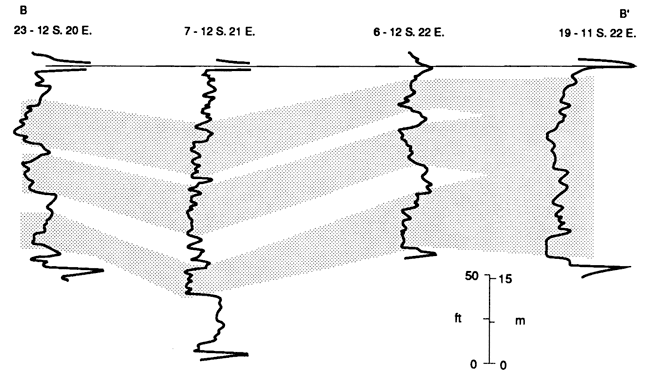
Cross section D-D'(modified from Lardner's B-B') shows a north-south section perpendicular to a linear sandstone trend (fig. 37). The thickest sandstones along the axis of the sandstone trend are identical to the fining-upward sequence seen in cross section C-C. However, away from the axis, the well-log signatures become more irregular and the sandstone unit thins abruptly. These changes indicate that the sandstone grades to interstratified sandstone and shale, and then to siltstone and shale.
Figure 37--Cross section D-D', strike-oriented view of Banzet sandstone bodies in east-central Kansas. See fig. 6 for location; modified from Lardner, 1984.
The sandstone of the upper interval is thinner and more widespread than the sandstone of the lower interval (fig. 38). The well-log signatures in cross sections C-C' and D-D' (figs. 36 and 37) are funnel shaped with gradational bases. These signatures seem to represent coarsening-upward sequences, although core samples were not available to verify this.
Figure 38--Sandstone-isolith map of upper portion of Banzet formation in east-central Kansas; from Lardner, 1984.
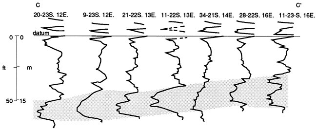
Sandstones in southeastern Kansas and northeastern Oklahoma--In the southeastern Kansas- northeastern Oklahoma portion of the study area, Denesen (1985) was able to divide the Banzet formation into four members, as was discussed in the previous discussion on stratigraphy. However, in the subsurface, coal beds that were used as marker beds for these members are difficult to trace. Some of those beds are discontinuous, while others thin to below the resolution of geophysical well logs. By tracing coal beds to their resolution limits and then picking up on other signatures, Denesen (1985) was able to place Banzet sandstone units into several intervals.
The interval between the top of the Ardmore limestone and the base of the Iron Post coal contains thick "shoestring" sandstone bodies which trend northeast-southwest (fig. 39). Some of these sandstone bodies cut down through the Ardmore limestone and underlying Oakley shale in Nowata, Washington, and Osage counties, Oklahoma. This relationship is illustrated in cross section E-E' (fig. 40; modified from Denesen's F-F), and its effects are shown both on the sandstone isolith map of this part of the study area for the Ardmore-Iron Post interval (fig. 39) and on the Banzet-Ardmore isopach map (fig. 28).
Figure 39--Sandstone-isolith map of Ardmore-Iron Post interval of Banzet formation in southeastern Kansas and northeastern Oklahoma; from Denesen, 1985.
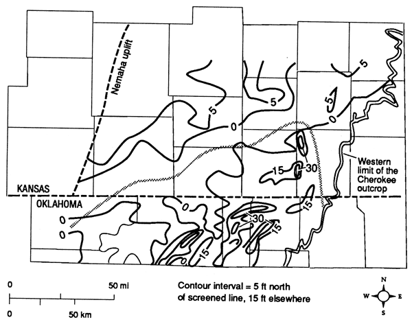
Figure 40--Cross section E-E', east-west view of Banzet sandstone bodies in northeastern Oklahoma. See fig. 6 for location; modified from Denesen, 1985.
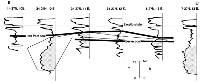
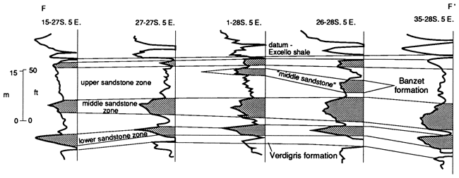
Above the Iron Post coal lies the Kinnison shale, which is considerably thicker in the subsurface than it is along the outcrop belt. The Kinnison thickens northward (fig. 41) as the amount of sandstone increases. Denesen (1985) was able to recognize two sandstone-rich zones within this interval. The lower of the two, which he referred to as the "middle sandstone zone," consists of thin, laterally discontinuous units, forming two major sandstone trends (fig. 29). The thickest trend lies parallel to the Nemaha uplift, extending from western Greenwood County and eastern Butler County southward to southeastern Sumner County, Kansas. Another trend extends southwestward from Woodson County, Wilson County, northwest Montgomery County, and into central Chautauqua County, Kansas (fig. 29). A north-south cross section, F-F' in Butler County, Kansas, shows that Denesen's "middle sandstone zone" consists of two separate bodies, the lower of which is more continuous than the upper body (fig. 42; modified from Denesen's cross section C-C).
Figure 41--Isopach map of Kinnison shale interval of Banzet formation; from Denesen, 1985.
The uppermost sandstones in the Kinnison shale and in the Banzet in general were referred to as the "upper sandstone zone" by Denesen (1985). These sandstone bodies are restricted to Kansas, pinching out in the southern tier of Kansas counties (fig. 29). Their well-log signatures consist of spike or funnel-shaped gamma-ray curves that indicate either thin, well-sorted sandstone or a coarsening-upward sequence with a gradational basal contact (fig. 42).
Figure 42--Cross section F-F', north-south view of Banzet sandstone bodies in Butler Co., Kansas. See fig. 6 for location; modified from Denesen, 1985.
Discussion
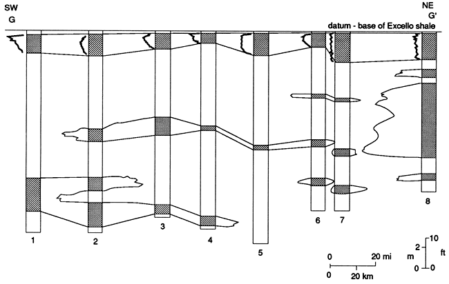
Following consideration of the distributions and well-log characteristics of Banzet lithologies in three map areas within the study area, several regional similarities and differences are apparent. First of all, individual sandstone bodies cannot be traced over areas more than a few counties in extent. Cross section G-G' (fig. 43) extends along the trend of a sandstone-rich thick from Miami County in the northeast, to Cowley County, Kansas, near the Oklahoma border in the southwest. Although most sandstone units are not traceable for the 270 km (168 mi) of the section, this cross section shows that they occur within definite zones or intervals.
Figure 43--Cross section G-G', northeast-southwest view of Banzet sandstone bodies between Miami and Cowley counties, Kansas, showing stratigraphic positions of sandstone bodies in Banzet formation. See fig. 6 for location of cross section and of wells 1-8.
Thicker sandstone units in all map areas tend to have sharp basal contacts and either bell-shaped or blocky log signatures. Thinner units have either spike or funnel-shaped log signatures. When complex sequences of log signatures occur, spiked or funnel-shaped signatures occur overlying blocky or bell-shaped signatures. When sand- stone units are traced laterally, the signatures grade into irregular serrated-curve patterns. Blocky and bell-shaped signatures change rapidly in strike-oriented cross sections and gradually in dip-oriented sections.
These vertical and lateral patterns of well-log signatures suggest that the thick, northeast-southwest-trending sandstones represent sharp-based channel complexes. The thinner, more extensive sandstone units with spike and funnel-shaped signatures seem to be upward-coarsening bar complexes. Irregular well-log patterns, into which the sandstone signatures tend to grade, represent interstratified sandstone and mudrocks. As mentioned earlier, cores from Leavenworth, Anderson, and Coffey counties, Kansas, confirm these interpretations when cored lithologies are compared with corresponding geophysical well logs.
Prev Page--Start of Stratigraphy || Next Page--Petrology
Kansas Geological Survey, Geology
Placed on web Oct. 27, 2010; originally published 1989.
Comments to webadmin@kgs.ku.edu
The URL for this page is http://www.kgs.ku.edu/Publications/Bulletins/GS3/03_strat2.html