![]()
Prev Page--Petrology || Next Page--Paleogeograpy, Petroleum Exploration
Paleontological observations
Fossils are scarce in the gray shales of the Banzet formation. The fossils that were found by Aden (1982) form low-diversity faunal assemblages. A common assemblage consists of poorly preserved productid brachiopods. The only genus identified was Desmoinesia sp. Some samples also contained the ostracode Cavellina sp. Only one outcrop section contained what is considered a normal marine assemblage. This is the Lawrence Cemetery section in Bates County, Missouri, where Aden (1982) collected the fossils of sea-cucumber scalerites and crinoid columnals, as well as productid brachiopods and ostracodes. He also recovered phosphatic fish scales from shale samples in the Neosho River Park section in Labette County, Kansas. In addition, carbonate concretions in the shale form around nuclei of brachiopod and gastropod remains.
The generally low abundances and diversity of fossils in the Banzet formation along its outcrop belt indicate deposition in restricted environments that underwent rapid changes. The productid brachiopods and ostracodes found may represent an eurytropic assemblage that was able to withstand broad salinity and turbidity fluctuations (Aden, 1982).
Depositional environments
Depositional environments are interpreted by integrating data and observations gathered from surface exposures, well cores, and geophysical well logs. Any one of these sources of information alone is inadequate to either interpret depositional environments or delineate paleodepositional systems. However, outcrops and cores provide relationships that allow geophysical well-log signatures to be interpreted in terms of lithologies and sequences of lithologies. The grid of well-log data is used to delineate both the vertical and lateral distributions of rock facies through their well-log signatures.
The interpreted rock sequences record a variety of sedimentary processes which were active within the Middle Pennsylvanian epeiric seaway. These process elements delineate areas of sand deposition in narrow "shoestring" bodies that form trends spatially associated with lobate sediment thicks (fig. 28) and high sandstone concentrations (fig. 29). Most of these lobes seem to be areas where sand and mud entered the seaway as river systems reached the seaway margins. The lateral and vertical progressions of process elements are similar to those found within fluvially dominated delta systems and associated environments.
Deltaic complexes
Upward-fining sequences of sandstones and silty mudstones characterize the central portions of lobate sandstone thicks. These always have sharp basal contacts, and core samples show that at least some of these have basal shale-chip conglomerates. The lateral distribution of these sequences shows them to form northeast-southwest-trending channels, as illustrated in cross sections A-A' (fig. 3 3) and B-B' (fig. 34). Off the sandstone trends, sandstones thin abruptly and grade into interstratified siltstone and shale as illustrated in the lower portion of cross section D-D' (fig. 37). The upper portions of sandstone channels are often associated with or overlain by coal beds such as shown in fig. 40. This pattern is repeated in both the upper and lower portions of the Banzet formation over the eastern and northwestern margins of the study area.
Each lobate pattern on the sandstone-isolith map represents one or more complexes of elongate delta lobes that formed during times that the shoreline encroached upon the study area. The northeast-southwest trends of relatively thick sandstone bodies represent main distributary-channel complexes of delta systems. Smaller divergent trends of fining-upward sandstones represent complexes of minor distributary channels and crevasse splays (fig. 54). Although many of the sandstone patterns appear lobate on the isolith map, individual sandstone trends are linear, indicating that individual lobes were elongate (fig. 54).
Figure 54--Diagrams showing spatial relationships between depositional environments in a high-constructive, elongate, fluvially dominated delta lobe. A) overall view of lobe, B) facies relationships associated with distributary channel; modified from Brown, 1979.
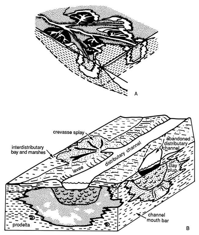
Thicknesses of delta-lobe complexes are generally less than 9 m (30 ft). This reflects the relatively low rates of subsidence in the Forest City basin and the Cherokee shelf compared to present-day situations along continental margins. In northeastern Kansas, the delta-distributary channel complexes are thicker than elsewhere and may include the lower portions of fluvial valleys. Rates of deposition probably exceeded accumulation rates by wide margins in this portion of the study area. Shifting channels resulted in a form of sedimentary cannibalism, where prograding channels eroded preexisting deposits and redeposited them in more basinward positions. Core samples from this area contain shale and coal chips at the bases of thick sandstone units (fig. 22).
Coal beds overlie mottled, light-gray to tan, clayey mudstone units where they were observed on outcrops and in cores. Although some coal beds are easily recognized on gamma-ray and neutron logs, many coaly horizons and underlying mudstone units are too thin to be recognized in this manner. The mudrocks are Pennsylvanian paleosols, or seatrock, that represent soils upon which coal-swamp vegetation grew.
Prodelta and interdistributary environments
Between and adjacent to sandstone thicks, the Banzet section consists primarily of mudrock with a Chin strata of siltstone and very fine grained sandstone. The lithologic characteristics and positions relative to interpreted deltaic lobes, as well as the clay mineralogies of sampled mudrocks and the distributions of fossil assemblages, all indicate prodelta and interdistributary environments of deposition.
Thin lenticular siltstone and sandstone beds encased within the mudrock sequences resulted from short periods of high-energy activities, which caused transportation of silts and sands from delta-distributary mouths to adjacent muddy-shelf areas. Evidence for this includes the sharp, nonerosional bases and upward fining of thin sandstones observed in cores and outcrops, such as those exposed at the Neosho River Park section in Labette County, Kansas (figs. 12 and 13). High-energy events were probably in the form of unusually severe fluvial floods caused by intense storm systems, similar to typhoons that rake equitorial areas today during monsoon seasons. A short-term increase in a deltaic, plane-jet flow could cause sands and silts, which were deposited earlier as distributary mouth-bar deposits, to be swept seaward into normally low-energy prodeltaic settings.
Crevasse-splay deposits also may have been deposited into interdistributary bays during floods. However, most of these deposits were later incorporated into the delta-lobe complex as distributary channels shifted within lobes. Only a splay formed along the outer edge of a lobe when it is occupying an extreme position relative to its lateral shifting would be identifiable as a splay in a delta-margin setting.
Marine-shelf environments
Portions of the Banzet formation are essentially sandstone-free and seem to represent low-energy shelf environments. For the most part, these intervals consist of clayey shale containing a diverse assemblage of fossils, relatively low proportions of kaolinite, and some calcareous units. The most extensive of these sandstone-free intervals are in the upper part of the Banzet in the southern half of the study area. These include the Kinnison shale and the Breezy Hill Limestone Member of the Mulky member of the Banzet formation.
The characteristics of these intervals show either more marine influence or greater distance from siliciclastic point sources than do the other portions of the Banzet. Energy levels were low with most sedimentation coming from suspension. The Breezy Hill member is a marine-carbonate unit that lacks any significant amounts of siliciclastic components. It reaches a maximum thickness in excess of 4.9 m (16 ft) in northern Washington and Nowata counties, Oklahoma, and southern Montgomery County, Kansas (fig. 55). It pinches out northward where it is underlain by prodeltaic mudstones and sandstones and overlain by a seat rock and the overlying Mulky coal.
Figure 55--Isopach map of Breezy Hill Limestone Member; from Denesen, 1985.
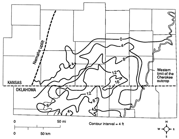
The Breezy Hill Limestone Member seems to represent shelf environments far removed from siliciclastic deposition. It probably was deposited during a widespread marine transgression when shorelines and delta systems were shifted to the north and east of the study area.
Lenses of sandstone, generally less than 3 m (10 ft) thick, occur in portions of shelf areas adjacent to deltaic and prodeltaic deposits. These upward-coarsening units seem to represent sand-bar fields that were the reworked remnants of previously deposited delta lobes. The seaward-most prograded delta lobes would have been the thinnest of these sequences deposited and would be more thoroughly reworked by marine currents and waves during subsequent transgressions. Initial concentrations of sands in distributary channels and channel-mouth bars were reshaped into bars that formed elliptical sand-sheets with long axes approximately parallel to the former channel trends. Examples of the sandstone bodies can be seen on the sandstone-isolith map in Neosho, Elk, Chautauqua, and Cowley counties, Kansas (fig. 29).
Prev Page--Petrology || Next Page--Paleogeograpy, Petroleum Exploration
Kansas Geological Survey, Geology
Placed on web Oct. 27, 2010; originally published 1989.
Comments to webadmin@kgs.ku.edu
The URL for this page is http://www.kgs.ku.edu/Publications/Bulletins/GS3/05_paleo.html