![]()
Prev Page--Introduction || Next Page--More on Stratigraphy
Stratigraphy
Abrupt lateral facies changes within the Cherokee Group complicate its stratigraphy. The relatively narrow, poorly exposed outcrop belt of the Cherokee does not reveal enough of the lateral and vertical relationships to adequately determine regional stratigraphy. Therefore, the stratigraphy of the Cherokee Group must be based on subsurface data, as well as surface exposures. Unfortunately, this integrative approach has not yet been applied to the entire Cherokee on a regional basis. Stratigraphic nomenclature schemes used by various workers not only do not agree with one another, but also have caused numerous miscorrelations between distant outcrops and between outcrops and subsurface sections. Resolution of the stratigraphic nomenclature problems within the Cherokee must wait until regional analysis of this entire rock package has been completed.
In this report, I will define an informal stratigraphic term, the "Banzet formation," to include the uppermost Cherokee rocks. This unit is spelled with a lower-case "f" to distinguish it from formally defined formations. Likewise, I will use informal members, each spelled with a lower-case "m" to ease rock descriptions. To help establish the stratigraphic framework for the Banzet, I will review the history and current usage of the stratigraphic nomenclature of Cherokee rocks.
History of stratigraphic nomenclature
The Pennsylvanian System of the midcontinent has traditionally been divided into five series based on biostratigraphic zones. In ascending order, these are the Morrowan, Atokan, Desmoinesian, Missourian, and Virgilian series. Morrowan and Atokan rocks are preserved in the Arkoma basin of Oklahoma, while rocks belonging to the latter three series are found on the Cherokee shelf and in the Forest City basin (Krumme, 1981). In the study area, the Cherokee Group traditionally has been classified as the lower part of the Desmoinesian Series. It unconformably overlies rocks of the Mississippian System and conformably underlies rocks of the Marmaton Group, which form the upper portion of the Desmoinesian. However, Ravn and others (1984) have reported Atokan fossils in the lower part of the Cherokee in Iowa.
The Desmoinesian was originally called the Des Moines Group by the U.S. Geological Survey, and according to Condra (1949), it included the interval between the Hertha Limestone and the top of the Mississippian System in northwest Missouri and southeast Iowa. Included within this group were the "Cherokee shales," a term coined by Haworth and Kirk (1894) to designate shale, sandstone, coal, and thin limestone in Cherokee County, Kansas. Moore (1932, 1936) redefined the Desmoinesian as a series to include the Marmaton and Cherokee groups.
At a conference held in Nevada, Missouri, March 31 -April 1, 1953, representatives from Iowa, Kansas, Missouri, Nebraska, and Oklahoma reached an agreement on division, classification, and nomenclature of Desmoinesian beds in these states. Older established names were retained with some redefinition, and new names were introduced to complete the classification.
Because of paleontological changes at the top of the Seville limestone (Kansas) or Inola limestone (Oklahoma), two substages, the Ventran and Cygnian, were adopted as time-stratigraphic divisions of the Desmoinesian. Two group names, Krebs and Cabaniss, were adopted to replace Cherokee (Howe, 1956). However, the term Cherokee was readopted by the Kansas Geological Survey, with the Krebs and Cabaniss being reclassified as subgroups. Because of the cyclic nature of Pennsylvanian rocks in the region, the representatives of the Nevada conference decided that the two new subgroups would be subdivided into formations, each consisting of strata between the top of a coal bed and the top of the next higher coal bed with four exceptions. These were named after the unit judged to be the most distinctive within the formation, regardless of the lithology. Usage of these formational units was restricted to areas where shelf conditions prevailed. However, at the present time, Missouri is the only state of the five which still subdivides the Desmoinesian Series by the guidelines set up at the Nevada conference.
Current stratigraphic nomenclature
Oklahoma
The term Cherokee is not recognized as a formal stratigraphic term in Oklahoma. Soon after the Nevada conference, the Oklahoma Geological Survey replaced it with the terms Krebs and Cabaniss, which were elevated from subgroup to group status. The boundary between the two was originally defined in the Arkoma basin, where a distinct paleontological break, change in character of sediments, and structural discordance occur at the Krebs-Cabaniss boundary (Oakes, 1953). This paleontological break was placed at the Inola limestone on the shelf, but because of the discontinuous nature of this limestone, the boundary is placed at the top of the Weir-Pittsburg coal, which overlies the Inola limestone on the shelf (Branson, 1957).
The Krebs Group is the lowest group in the Desmoinesian and includes all rocks between the top of the Atoka Formation and the top of the Boggy Formation (fig. 7). It contains the following formations in ascending order: Hartshorne, McAlester, Savanna, and Boggy.
Figure 7--Comparison of Cherokee stratigraphic terms used on Cherokee shelf of eastern Kansas and northeastern Oklahoma and terms used in Arkoma basin; modified from Krumme, 1981.
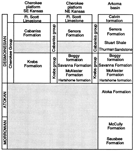
Krebs Group thickness varies from 2,438 m (8,000 ft) in the basin to 104 m (340 ft) near the Kansas-Oklahoma border (Oakes, 1953). On the shelf, the Krebs contains prominent sandstones, limestones, and coals. These include the Warner, Bluejacket, and Taft sandstones (Warner, Bartlesville, and Red Fork sandstones of the subsurface), Sam Creek and Spaniard limestones (Brown limestone of the subsurface), Inola limestone, and the Riverton, Rowe, Drywood, and Weir-Pittsburg coals (fig. 7).
The Cabaniss Group contains all rocks between the top of the Krebs Group and base of the Marmaton Group. Its boundaries are marked by the top of the Weir-Pittsburg coal, below, and the top of the Excello shale, above. In the Arkoma basin, the Cabaniss is approximately 305 m (1,000 ft) thick, but thins to about 49 m (160 ft) near the Kansas-Oklahoma border (Oakes, 1953). The Cabaniss contains the following formations in ascending order: Thurman Sandstone, Stuart Shale, and Senora formation (fig. 7). From the basin northward, the Thurman Sandstone is overlapped by the Stuart Shale at a point near the Canadian River. In turn, the Stuart Shale is overlapped by the Senora formation in the vicinity of T. 13 N., R. 16 E. From this point, the Senora formation rests unconformably upon the Boggy Formation of the Krebs Group northward into Kansas (Ware, 1955).
Lithologically, the Senora formation resembles the Krebs Group in that it contains shale; discontinuous, lenticular sandstones; and several thin, persistent limestones and economically important coals. Prominent beds include the Chelsea, Goldenrod, and Lagonda sandstones (lower Skinner, upper Skinner, and Prue or "squirrel" sandstones of the subsurface); Tiawah limestone (pink lime of subsurface), Verdigris and Breezy Hill limestones; Tebo, Mineral, Croweburg, and Iron Post coals, and the black shales beneath the Tiawah and Verdigris limestones (fig. 7).
Kansas
The term Cherokee Group is recognized as a formal stratigraphic unit in Kansas. The type locality of the Cherokee Group is in Cherokee County, Kansas (Howe, 1956). The Krebs and Cabaniss subgroups were renamed as formations by Jewett (1959), with prominent coals, limestones, and sandstones used to define members of these two formations (Zeller, 1968).
The Krebs Formation was defined as consisting of rocks lying above the top of the Atoka Formation in the Arkoma basin of southern Oklahoma, and below the top of the Seville limestone (fig. 7). In sections where Atokan fossils have not been found and where the Seville has an erratic distribution over southeastern Kansas, the lower Krebs boundary is generally regarded as the top of the Mississippian System, while its upper boundary has been placed at the top of the Bluejacket Sandstone Member, which underlies the Seville. Krebs thickness on outcrops varies from 61 to 76 m (200-250 ft; Zeller, 1968). Listed in ascending order, prominent members of this formation include the Riverton coal, Drywood coal, Bluejacket Sandstone Member, and Seville limestone.
Rocks lying above the Seville or Bluejacket and below the top of the Excello shale belong to the Cabaniss Formation. On outcrop, the formation thickness averages 67 m (220 ft; Zeller, 1968). Prominent members include the Weir-Pittsburg, Tebo, Scammon, Mineral, Croweburg, and Bevier coals; Chelsea and Lagonda sandstones; and the Verdigris and Breezy Hill limestones (fig. 7).
The Banzet formation--an informal rock unit
The Verdigris Limestone Member of Oklahoma is traceable into Missouri where it has been named the Ardmore limestone by Gordon (1896). The black shale beneath the Verdigris-Ardmore limestone can be traced throughout the study area using gamma-ray logs. It can be traced along outcrop and in the subsurface from Oklahoma through eastern Kansas and western Missouri and into Iowa, where it recently has been named the Oakley Shale (Ravn and others, 1984). The lateral persistence of the Verdigris-Ardmore limestone and the Oakley Shale throughout the region establishes them as reliable lithostratigraphic markers. Following the historic precedent set by Gordon (1896) and the Missouri Geological Survey, I will refer to this unit as the Verdigris Formation, which includes the Ardmore Limestone Member above, and the Oakley Shale Member below (fig. 8). The lithologies that overlie the Verdigris will be referred to as the Banzet formation, an informal rock-stratigraphic unit. The lithologies below the Oakley Shale and above the Croweburg coal can be placed as a lower member of the Verdigris Formation.
Figure 8--Informal stratigraphic nomenclature used in this study for upper portion of Cherokee Group on the Cherokee shelf and Kansas portion of Forest City basin. formations can be traced over the entire region. Members and key beds are recognized only in southern portion of study area; modified from Denesen, 1985.
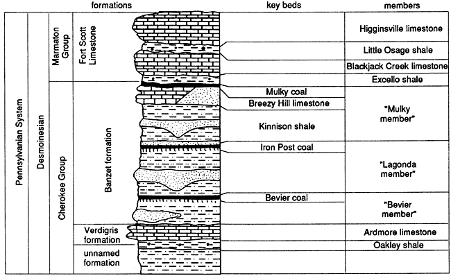
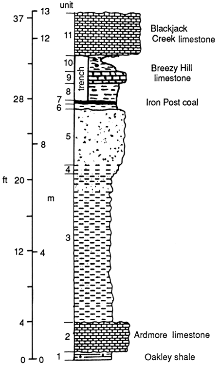
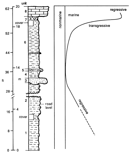
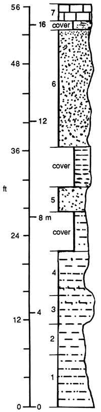
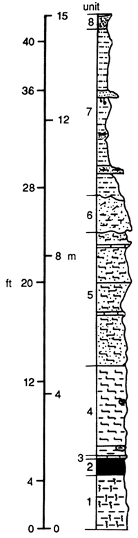
The informal Banzet formation lies between the top of the Verdigris Formation and the base of the Excello shale. This stratigraphic interval, which has been the focus of the studies reported in this bulletin, was named after the ghost town of Banzet in Craig County, Oklahoma. An informal "type section" for the Banzet formation is in SW SW sec. 30, T. 28 N., R. 20 E., Craig County, Oklahoma, where a section of the Verdigris and Banzet formations, and the Excello shale, between the base of the Oakley Shale and the base of the Blackjack Creek limestone, is exposed in a roadcut along OK-10 (fig. 9). Denesen (1985) was able to divide the Banzet into four members along and adjacent to the outcrop belt. For simplicity in describing the Banzet, I will use Denesen's members as informal units.
Figure 9--Description of "type section" of Banzet formation west of Welch (SW SW sec. 30, T. 28 N, R. 20 E.), Craig County, Oklahoma.
| SW SW SW sec. 30, T. 28 N., R. 20 E. Craig County, Oklahoma |
||
|---|---|---|
| Measured in roadcut along OK-10 by Robert L Brenner, 1980; trenched in 1982 | ||
| Type section of the Banzet formation and principal reference section of the Verdigris formation | ||
| Unit 11 | 11.3-13.0 m (36.2-41.6 ft) |
Fossiliferous limestone |
| Unit 10 | 10.9-11.3 m (34.9-36.2 ft) |
Black phosphatic clay shale |
| Unit 9 | 10.3-10.9 m (33.0-34.9 ft) |
Fossiliferous limestone |
| Unit 8 | 9.7-10.3 m (31.0-33.0 ft) |
Slightly calcareous light shale, medium-dark gray |
| Unit 7 | 9.6-9.7 m (30.7-3 1.0 ft) |
Coal, poorly exposed |
| Unit 6 | 9.4-9.6 m (30.1-30.7 ft) |
Claystone, medium-light-gray |
| Unit 5 | 7.3-9.4 m (23.3-30.1 ft) |
Sandstone, fine- to medium-grained; regular laminae at base, mottled toward top; central part poorly exposed |
| Unit 4 | 7.0-7.3 m (22.4-23.3 ft) |
Interstratified sandstone and siltshale; fissile beds less than 1 cm thick; gradational lower contact |
| Unit 3 | 1.4-7.0 m (4.4-22.4 ft) |
Siltshale, medium-gray; contains some thin siltstone and sandstone beds which increase in frequency upward |
| Unit 2 | 0.3-1.4 m (0.9-4.4 ft) |
limestone; wacke-packstone |
| Unit 1 | 0--0.3 m (0-0.9 ft) |
Clayshale, black; contains phosphate nodules. |
If the Banzet formation were to be made into a formal rock-stratigraphic unit, it would necessitate major revisions in Kansas and Oklahoma stratigraphic-nomenclature schemes. However, more detailed subsurface stratigraphic studies of rocks below the Banzet must be completed before revisions of Cherokee stratigraphic terminology can be intelligently attempted. After this is done, the stratigraphic nomenclature for the entire Cherokee Group in the midcontinent needs to be reevaluated by representatives from all states involved. A nomenclature-correlation scheme should be agreed upon that takes into account all data from both surface exposures and subsurface wells. Until these studies are completed and a nomenclature-correlation scheme is agreed upon, I will use the Banzet formation, as defined above, as an informal formation within the Cabaniss subgroup.
Outcrop descriptions
The upper Cherokee outcrop belt trends across the southeastern portion of the study area from Bates County, Missouri, through portions of Bourbon, Crawford, Cherokee, and Labette counties, Kansas, and through Craig and Rogers counties, Oklahoma. Exposures are discontinuous and rarely contain the entire Verdigris-Banzet section. However, composite sections have been constructed using two or more nearby exposures. The stratigraphic positions and lithologic characteristics of the Oakley and Excello black shales and the Ardmore limestone are consistent throughout the outcrop belt. On the other hand, the gray shales, coals, sandstones, and the Breezy Hill Limestone Member of the Banzet formation vary considerably in lithology and thickness from the northeast to the southwest along the outcrop belt.
Oakley shale of the Verdigris Formation
The Oakley shale member of the Verdigris Formation consists of very dark gray to black, fissile clay shale that overlies dark-gray shale. The unit ranges in thickness from 0.5 m (1.5 ft) to 1.8 m (5 ft). The black shale contains oblate spheroidal, dark-gray phosphate nodules with maximum diameters of less than 1 cm. Conodonts were observed in the black shale and other marine fossils in gray shales of the Oakley.
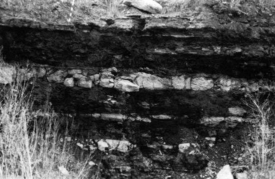
Ardmore limestone of the Verdigris Formation
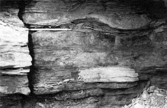
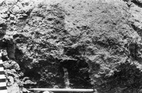
The Ardmore limestone member of the Verdigris Formation consists of an olive-gray to dark-olive-gray, dense biomicrite containing marine brachiopods, bryozoa, echinoderm debris, corals, and algal fragments. Its thickness has been reported to vary from 0.6 m (2 ft) to 4.3 m (14 ft) (Denesen, 1985), but ranges between 1.1 m (3.5 ft) and 1.5 m (4.8 ft) in the exposures where they were measured along the outcrop belt. The southernmost exposure studied was in the spillway of the Lake Bixhoma dam in sec. 2, T. 16 N., R. 14 E., Wagoner County, Oklahoma. At that locality, the limestone is split into two 0.3-m (1-ft)-thick beds by a 0.3-m (i-ft)-thick bed of dark-gray shale (fig. 10). This shale pinches out northward, so that exposures of the Ardmore in Craig County, Oklahoma, consist of a single limestone unit. Howe (1956) reported that the Ardmore splits into three limestone units separated by dark-gray shale in Cherokee and Crawford counties, Kansas. Unfortunately, many of these were exposed in coal pits that have since been covered. Two pits that were still accessible in the early 1980's showed a single 1.5-m-thick biomicrite in Cherokee County (NE sec. 13, T. 32 S., R. 22 E.) and three thin limestone units separated by dark-gray shale in a 3-m (10-ft) interval in northern Crawford County (SE sec. 9, T. 28 S., R. 25 E.) (fig. 11).
Figure 10--Contact between Oakley shale and Ardmore limestone which forms a ledge in the Lake Bixhoma spillway, south of Tulsa, Oklahoma; note a thin shale break within the Ardmore.
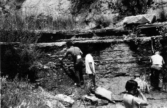
Figure 11--Contact between Oakley shale and Ardmore limestone in coal-pit headwall west of Croweburg (SW SE SE sec. 9, T. 28 S., R. 25 E.), Crawford County, Kansas. This headwall has since been covered by a reclamation project.
Bevier member of the Banzet formation
The interval between the top of the Ardmore limestone and the Bevier coal consists of a thin, dark-gray shale overlain by a medium-gray seatrock beneath the coal. Accessible exposures are poor; however, the Bevier member can be seen in several exposures in Craig County, Oklahoma, in southeastern Kansas, and in Bates County, Missouri. This member is generally less than 8 m (26 ft) thick along the outcrop bell South of Craig County, the Bevier coal is not exposed (Denesen, 1985). In Craig County, Oklahoma, this member consists of a coarsening-upward sequence of clay shale, silt shale, and fine-grained sandstone, capped by a clayey seatrock and the Bevier coal.
Two types of sandstone occur within the Bevier member in Oklahoma. One type is a light-gray to medium-brownish-gray, fine-grained, ripple-laminated sandstone that is interstratified with light-to-medium-gray siltstone. The other type is a fight-olive-gray, medium-grained, crossbedded sandstone with cross sets dipping southward at 15-20°. This sandstone has a sharp, erosional basal contact with underlying silt shales.
In Labette County, Kansas, the Bevier member consists of 2.5 m (8.3 ft) of thin-bedded, fine-grained sandstone. Further to the northeast in Bourbon and Crawford counties, Kansas, the Bevier coal and its clayey seatrock lie directly above the Ardmore limestone.
Along the Marais des Cygnes River northeast of Foster in Bates County, Missouri, the Bevier coal is a thin seam that can only be observed at low river levels.
Lagonda member of the Banzet formation
In Craig County, Oklahoma, the Lagonda member consists of a fining-upward sequence of sandstone, siltstone, and silt shale that lies directly upon the Bevier coal. This member thins from 6.2 m (20 ft) in the north in sec. 29, T. 27 N., R. 19 E. to 1.1 m (3.5 ft) in the south in sec. 28, T. 25 N., R. 18 E. (Denesen, 1985). The sandstone units are medium-to-fine grained, micaceous, platy subarkose. The basal contacts commonly show load features, and the upper portions of the sandstone units are ripple-laminated and interstratified with medium-gray silt shale.
The lower portion of the interval between the top of the Bevier coal and the base of the Breezy Hill Limestone, corresponding to the Lagonda member, consists mostly of dark-gray clay shale with thin limestone beds that contain fossil brachiopods, pelecypods, and gastropods. Lenses and nodules of argillaceous micritic carbonate occur locally in some shale units. The interval, which includes the Lagonda and Mulky members, thickens northward from 9.5 m (31 ft) in sec. 16, T. 31 S., R. 23 E., Crawford County, to 23 m (77 ft) in sec. 32, T. 27 S., R. 25 E., Crawford County. The outcrop of this interval in Bates County, Missouri, is at least 11 m (37 ft) thick. It consists of dark-gray shales with thin, fossiliferous limestone units in its lower portion. Thin, fine-grained sandstones are restricted to the upper portion of the interval (Mulky member) on Kansas and Missouri exposures.
Mulky member of the Banzet formation
Above the Iron Post coal in northeastern Oklahoma, a wedge of dark-gray clay shale, named the Kinnison shale by Howe (1951), comprises the bulk of the Mulky member. The Kinnison thins northward in Craig County, Oklahoma, to less than 0.6 m (2 ft). This unit cannot be recognized in Kansas or Missouri exposures. This is due to an increase in silt content of the shales and the inclusion of thin sandstone units within the Mulky member in northernmost Craig County (e.g., Banzet type section; fig. 9) and into Kansas and Missouri.
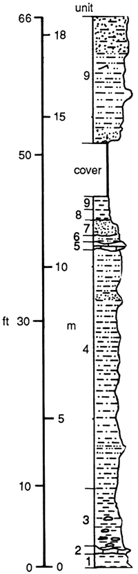
The sandstone units exposed in the Neosho River section, Labette County, Kansas (fig. 12) consist of three beds, the thickest of which is 0.4 m (1.3 ft) thick. The sandstones are well sorted, very fine grained, and horizontal and ripple cross laminated, with sharp basal contacts that form load casts into the underlying shale (fig. 13). In the McCollum farm (fig. 14) and the Osage cemetery (fig. 15) sections in southern Crawford County, Kansas, 5 m (16.4 ft) of very fine grained, wavy-laminated sandstone crop out just below the Breezy Hill Limestone Member. The sandstone is similar in nature to those observed in Labette County but is higher in the section. The best exposures of Mulky member sandstones are in the Breezy Hill area of northern Crawford County in the North Arma (fig. 16) and West Croweburg sections. The sandstone units in each of these sections are 3 m (10 ft) thick and lie directly below the Breezy Hill Limestone Member. On both outcrops, the sandstones are horizontally laminated, wavy, and ripple cross laminated, with prominent load casts where sandstone over shale contacts are exposed (fig. 17). In this area, the sandstone units are capped by the Breezy Hill Limestone Member.
Figure 12--Description of Neosho River Park section, Oswego (SW SW NE sec. 15, T. 33 S., R. 21 E.), Labette County, Kansas.
| Oswego-Neosho River section Riverside Park Road--SW SW NE sec. 15, T. 33 S., R. 21 E., Labette County, Kansas |
||
|---|---|---|
| Measured by R. L. Brenner, May 25, 1980 | ||
| Unit 8* | 19.0-20.0 m (60.89-64.09 ft) |
Limestone; wackestone-packstone grains appear to be mostly crinoidal debris; basal contact sharp |
| Unit 7* | 18.5-19.0 m (59.2-60.8 ft) |
Clay shale, black, with phosphate nodules; fissile; base not exposed |
| Unit 6 | 13.9-18.5 m (44.5-59.2 ft) |
Shale; with scattered thin, ripple- laminated beds; sharp basal contact; top partially covered |
| Unit 5 | 13.7-13.9 m (43.9-44.5 ft) |
Sandstone, very fine grained, ripple laminated; shale partings near gradational base |
| Unit 4 | 13.0-13.7 m (41.6-43.9 ft) |
Clayey shale with silty beds near top, medium-gray, very fissile; abruptly gradational base |
| Unit 3 | 12.6-13.0 m (40.3-41.6 ft) |
Sandstone, fine-grained, micaceous quartz arenite; load structure at base causes unit thickness to vary; calcite cemented in places; no visible stratigraphy(homogenous); basal contact sharp--no evidence of erosion |
| Unit 2 | 3.6-12.6 m (11.5-40.3 ft) |
Interbedded shale (50% clay, 50% silt) and clayey shale, both medium-gray, noncalcareous; some carbonaceous (plant) fragments on stratified planes |
| 3.0-3.6 m (9.6-11.5 ft) |
Covered interval | |
| Unit 1 | 0-3.0 m (0-9.6 ft) |
Clay shale, medium-gray, tan-weathering |
Figure 13--Load structures at base of lowest sandstone bed in Neosho River Park section.
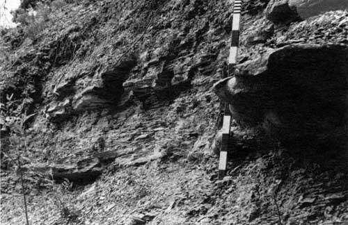
Figure 14--Description of McCollum Farm section (center SE sec. 36, T. 30 S., R. 22 E., Crawford County, Kansas).
| McCollum Farm section Center SE sec. 36, T. 30 S., R. 22 E., Crawford County, Kansas |
||
|---|---|---|
| Measured by R. L. Brenner, May 1980 | ||
| Unit 7 | 8.6-10.0 m (27.56-32.04 ft) |
Limestone; skeletal packstone-grainstone; sharp basal contact |
| Unit 6 | 8.3-8.6 m (26.59-27.56 ft) |
Limestone; fossil; wackestone; sharp basal contact |
| Unit 5 | 6.0-8.3 m (19.22-26.59 ft) |
Clay shale; black, fissile, with phosphate nodules in upper 1.5 m; lower 0.8 m is partially covered; basal contact is not exposed |
| Unit 4 | 5.4-6.0 m (17.62-19.22 ft) |
Limestone; fossil; wackestone; mottled; rusty-weathering; basal contact not exposed |
| 4.4-5.5 m (14.10-17.62 ft) |
Covered interval; trenched and found fine-grained, regular-to-irregular lamination; slabby sandstone | |
| Unit 3 | 2.2-4.4 m (7.05-14.10 ft) |
Sandstone, very fine grained, regular lamination, slabby aspect; gradational basal contact |
| Unit 2 | 1.5-2.2 m (4.80-7.05 ft) |
Sandstone, fine-grained, irregular-wavy thin beds and lamination, slightly calcereous; abruptly gradational basal contact |
| Unit 1 | 0.0-1.5 m (0-4.80 ft) |
Very fine grained sandstone and siltstone; regular-to-irregular thin beds and lamination, slightly calcereous, some coaly partings; basal contact not exposed |
| Interval beneath this section is covered | ||
Figure 15--Description of Osage Cemetery section (NE SE sec. 25, T. 30 S., R. 22 E.), Crawford County, Kansas.
| Osage cemetery section NW NW SW sec. 30, T. 30 S., R. 22 E., Crawford County, Kansas |
||
|---|---|---|
| Lower 14.9 m (47.75 ft) measured by R. L. Brenner, May 1980; upper 3.1 m (9.93 ft) measured by L J. Aden, May, 1981 | ||
| Unit 7 | 17.4-18.0 m (55.7-57.6 ft) |
Fossilfferous limestone; wackestone, mottled; basal contact not exposed |
| 14.9-17.4 m (47.7-55.7 ft) |
Covered interval; sandstone and shale float | |
| Unit 6 | 10.5-14.9 m (33.6-47.7 ft) |
Sandstone, fine-grained, regular lamination with some bioturbation, calcareous along some strata; upper 3.4 m (10.8 ft) poorly exposed due to increasing shale interbeds; base not exposed |
| 9.0-10.5 m (28.8-33.6 ft) |
Covered interval; dark-gray shale float | |
| Unit 5 | 8.0-9.0 m (25.6-28.8 ft) |
Sandstone, fine-grained, mottled (exterior bioturbation), with some irregular lamination; calcareous cementing along some strata gives slabby outcrop appearance; base not exposed |
| 6.5-8.0 m (20.8-25.6 ft) |
Covered interval; dark-gray clay shale float | |
| Unit 4 | 4.7-6.5 m (15.0-20.8 ft) |
Silty shale, olive-gray, slightly calcareous, regular lamination and thin beds (1-2 cm; .39-.78 in); abruptly gradating basal contact |
| Unit 3 | 3.4-4.7 m (10.8-15.0 ft) |
Silty shale-silt shale; olive-gray calcite, iron-stained strata form slabby ledges; gradational basal contact |
| Unit 2 | 2.3-3.4 m (7.3-10.8 ft) |
Interstratifed calcareous siltstone and clay shale, light-gray and dark-gray; increasing siltstone upward; gradational basal contact |
| Unit 1 | 0.0-2.3 m (0.0-7.3 ft) |
Clay shale, medium-dark-gray, with flattened limestone lenses up to 10 cm (3.93 in) thick scattered through interval |
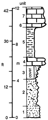
Figure 16--Description of North Arma section (SW SW sec. 32, T. 27 S., R. 25 E.), Crawford County, Kansas.
| North Arma section--US-69 SW NW SW sec. 5, T. 28 S., R. 25 E. and SW SW SW sec. 32, T. 27 S., R. 25 E., Crawford County, Kansas |
||
|---|---|---|
| Measured by R. L. Brenner, May 22, 1980 | ||
| Unit 11 | 10.65-13.2 m (34.-42.3 ft) |
Limestone-skeletal packstone-grainstone; chaetetid heads, forams, crinoids; sharp basal contact |
| Unit 10 | 10.0-10.65 m (29.1-34.1 ft) |
Limestone-biomicrite, corroded upper surface; sharp basal contact |
| Unit 9 | 9.1-10.0 m (29.1-29.1 ft) |
Clay shale, black, highly fissile; abundant phosphatic nodules; upper 0.55 m (1.76 ft); sharp basal contact |
| Unit 8 | 8.75-9.1 m (28.0-29.1 ft) |
Coal |
| Unit 7 | 8.2-8.75 m (24.3-28.0 ft) |
Claystone, mottled, medium-gray; mottled, increasing coaly fragments upward, contact sharp (poorly exposed) |
| Unit 6 | 7.6-8.2 m (24.3-24.3 ft) |
Micritic limestone, gray with red-brown (rusty) weathering, mottled; sharp irregular basal contact |
| Unit 5 | 6.2-7.6 m (19.8-24.3 ft) |
Sandstone, fine-medium-grained, ripple Laminated, slabby; some thin clay shale lamination; calcite and iron-oxide cement; gradational basal contacts |
| Unit 4 | 5.9-6.2 m (18.9-19.8 ft) |
Sandstone, fine-medium-grained, massive-to-rippled; cemented with calcite and iron-oxide; sharp basal contact |
| Unit 3 | 3.9-5.9 m (12.4-18.9 ft) |
Interbedded (thin) laminated medium-light-gray clay shale and very fine grained siltstone slightly calcareous contact in upper 0.5 m (1.6 ft); sharp (nonerosion) contact marked by color change on outcrop |
| Unit 2 | 1.8-3.9 m (5.7-12.4 ft) |
Clayey shale, slightly calcareous, slabby, medium-olive-gray on fresh surfaces; unidentified fossil imprints and pyrite cubes on stratified surface; argillaceous calcitic concretions 10-70 cm (3.9-27.5 in) thick, form discontinuous layer at 2.5-2.7 m (8.0-8.6 ft); gradational basal contact |
| Unit 1 | 0.0-1.8 m (0.0-5.7 ft) |
Clay shale, medium-dark medium-olive- gray; exposed in trench dug through cover |
Figure 17--Load features in sandstone-shale sequence in road cut 200 m (667 FT) west of coal-pit headwall pictured in fig. 11; pencil is 18 cm long.
In Missouri, the Mulky member sandstones vary considerably between exposures. At the Northeast Foster section (fig. 18), the sandstone lies at the top of the interval and appears similar to the sandstone exposures in northern Crawford County, Kansas. At the Lawrence cemetery composite section (fig. 19) in Vernon County, Missouri, the sandstone is found in a 5-m (16.4-ft) sequence of interbedded, mottled and ripple-laminated sandstone and medium-dark-gray shale. The sequence seems to become more sandy up to a point 3 m (10 ft) below the top of the section. Above that level, the section is mostly shale with a few thin, very fine grained sandstone beds (Aden, 1982).
Figure 18--Description of northeast Foster section (SE sec. 6, T. 39 N., R. 32 W., Bates County, Missouri).
| Northeast Foster section SE sec. 6, T. 39 N., R. 32 W., Bates County, Missouri |
||
|---|---|---|
| Measured by L J. Aden, May 1981 | ||
| Unit 9 | 14.0-17.5 m (44.8-56.0 ft) |
Interstratified sandstone, siltstone, and shale; increasing sandstone upward; sandstone (?) beds are ripple-laminated; basal contact not exposed |
| 12.2-14.0 m (39.0-44.8 ft) |
Covered interval; shale float | |
| Unit 8 | 11.22-12.2 m (35.95-39.0 ft) |
Mudstone; very fossiliferous, with ostracodes and productid brachiopods well preserved |
| Unit 7 | 10.9-11.22 m (34.9-35.95 ft) |
Mudstone; not fossiliferous |
| Unit 6 | 10.6-10.9 m (33.9-34.9 ft) |
Sandstone, fine-grained, very fossiliferous |
| Unit 5 | 10.4-10.6 m (33.3-33.9 ft) |
Limestone; fossiliferous wackestone |
| Unit 4 | 2.5-10.4 m (8.0-33.3 ft) |
Shale with interstratified siltstone beds that are up to 1.0 m (3.2 ft) thick; siltstone is irregular-wavy laminated with some ripple cross lamination; poorly preserved productid brachiopod spines are common at base of interval and decreasing upward |
| Unit 3 | 0.6-2.5 m (1.92-8.01 ft) |
Interstratified shale and silty shale, medium-dark-gray; lenses of iron-rich carbonate mudstone occur between 0.7 and 2.0 m (8.0-6.4 ft) |
| Unit 2 | 0.5-0.6 m (1.6-1.9 ft) |
Limestone, wavy-bedded, fossiliferous |
| Unit 1 | 0.0-05 m (0.0-1.6 ft) |
Silty shale |
| Base of section underlain by a coal bed that lies beneath river waters except at low-water stages | ||
Figure 19--Description of Lawrence Cemetery section (SE NE sec. 5, T. 37 N., R. 33 W.), Vernon County, Missouri.
| Lawrence Cemetery section SE NE sec. 5, T. 37 N., R. 33 W., Vernon County, Missouri |
||
|---|---|---|
| Measured by L J. Aden, May 1981 | ||
| Unit 8 | 13.8-14.3 m (44.2-45.8 ft) |
Sandstone, fine-grained; ripple cross lamination, mottled (burrows) |
| Unit 7 | 9.3-13.8 m (29.8-44.2 ft) |
Clay shale with thin beds of very fine grained sandstone; sharp basal contact |
| Unit 6 | 8.3-9.3 m (26.5-29.8 ft) |
Sandstone, very fine grained; lower portion calcareous; sharp basal contact |
| Unit 5 | 4.4-8.3 m (14.1-26.5 ft) |
Interstratified calcarerous shale and siltstone; ostracodes in shale |
| Unit 4 | 2.04.4 m (6.4-14.1 ft) |
Shale, medium-gray, calcareous; echindoderm fragments; contains at least two stratigraphic horizons with lenses of carbonate nodules |
Breezy Hill Limestone Member of Banzet formation
The Breezy Hill Limestone Member was named by Pierce and Courtier (1937) from a coal-pit headwall in northeastern Crawford County, Kansas, where a 1-m (3.3-ft)-thick fossiliferous marine limestone was exposed. North of this area, the Breezy Hill becomes a mottled caliche or rhizolite (Knight, 1985). This can be seen at the North Arma section (fig. 20). From eastern Crawford County southwestward into northeastern Oklahoma, the Breezy Hill Limestone Member is a skeletal calcilutite and calcarenite with marine fossils. The maximum thickness of the Breezy Hill Limestone Member observed was 3 m (10 ft) in sec. 14, T. 21 N., R. 15 E., Rogers County, Oklahoma, and sec. 25, T. 26 N., R. 18 E., Craig County, Oklahoma (Denesen, 1985).
Excello shale
The Excello shale can be traced the entire length of the outcrop in the study area. It consists of fissile, phosphatic, black-clay shale with conodonts that are visible on the outcrop. Calcareous concretions are concentrated in layers in some Excello outcrops. Along the north side of US-160 in SE SE sec. 16, T. 31 S., R. 23 E., Crawford County, Kansas, these concretions merge forming a limestone bed having a maximum thickness of about 0.5 m (1.3 ft). This bed cannot be traced laterally between outcrops nor could it be recognized in the subsurface on well logs. The Excello shale is 1.5-2.0 m (5-6.2 ft) thick in northeastern Oklahoma and up to 2.5 m (8.6 ft) in southeastern Kansas.
Figure 20--Mottled Breezy Hill limestone in upper portion of North Arma section; scale in lower left hand corner is in centimeters.
Core descriptions
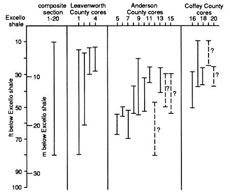
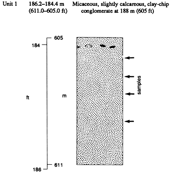
Many of the wells that were drilled to test the petroleum potential of Banzet sandstone units were cored. Unfortunately, due to lack of storage facilities, most of the core materials were lost after they were analyzed by their owners. Fortunately, some cores were given to and stored by the Kansas Geological Survey, and other cores were made available by various drillers. These cores, which were clustered in three Kansas counties, provided representative samples of sandstone units from several horizons within the Banzet formation. However, mudrock units were poorly represented since only mudrock associated with sandstones was cored. Fig. 21 summarizes the lateral and stratigraphic positions of core samples that were analyzed.
Figure 21--Chart showing relative stratigraphic positions of core samples used in this study.
| 1=HAR | 6=BL-18 | 11=H-20 | 16=IM-8 |
| 2=HEM | 7=BL-16 | 12=J-22 | 17=LB-3 |
| 3=IR-2 | 8=K-31 | 13=HB | 18=KB-1 |
| 4=GR-1 | 9=H-8-2 | 14=L-36-2 | 19=LP-6 |
| 5=BB-1 | 10=O4A | 15=BEN | 20=LWB-4 |
Leavenworth County cores
In northern Kansas, available cores were confined to Leavenworth County. Nelson (1985) analyzed these cores and recognized five lithofacies: 1) homogeneous pebble-to-boulder conglomerate; 2) fine- to medium-grained litharenites that are homogeneous to thickly horizontally bedded; 3) fine- to medium-grained litharenites with unimodel, large-scale cross stratification; 4) ripple cross stratified, fine-grained litharenite; and 5) interlaminated shale and siltstone with thin coal seams.
Conglomerate units have sharp, erosional basal contacts and overlie either sandstone or siltstone-shale units. They form the basal units of fining-upward sequences that may contain any or all of the lithofacies listed above (fig. 22). The fine- to medium-grained sandstone units that commonly overlie the conglomerates are oil stained and micaceous, with mica flakes concentrated on some bedding planes. These sandstones are the most porous and permeable and seem to have the lowest amounts of clay minerals (Nelson, 1985). Overlying cross stratified and rippled sandstones also are oil stained, but not to the degree that the horizontally bedded units are. The upper portions of ripple cross stratified units are flaser bedded with thick laminae and thin beds of mudstone separating sets of ripples. Siltstone or very fine grained sandstone lenses and starved ripples commonly occur in the lower portions of the interlaminated shale and siltstone units. This lithofacies also is marked by concentrations of mica flakes and carbonized plant debris on bedding planes as well as thin coal seams and iron-carbonate-rich claystone laminae.
Figure 22--Lithofacies recognized in core samples from Leavenworth County, Kansas, and deduced from well-log signatures in northeastern Kansas; from Nelson, 1985.
Anderson County cores
Lithologies associated with sandstone trends in Anderson County, Kansas, were studied by Reinholtz (1982). He recognized five lithofacies: 1) homogenous, fine-grained, micaceous sandstone; 2) fine-grained sandstone interstratified with lesser amounts of silt and clay shales; 3) subequal amounts of interstratified fine-grained sandstone and shale; 4) interstratified siltstone and silty shale; and 5) clayey shales with minor lenticular laminae of siltstone.
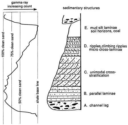
The homogenous, fine-grained, micaceous sandstone facies is often thick, having been observed in 4.6 m (15.1 ft) of continuous core in the Bailey-Lohrengel 18 core (fig. 23). The base of this unit is marked by a thin shale-chip conglomerate that is similar to, but finer grained than the conglomeratic units described in the Leavenworth County cores.
Figure 23--Core description from Bailey-Lohrengel 18 well in Anderson County, Kansas; from Reinholtz, 1982.
The interstratified sandstone and mudrock facies contain a variety of stratification types including regular and irregular wavy-thin beds, ripple cross lamination, thin sets of high-angle tabular crossbeds, flaser bedding, and minor bioturbation structures (Reinholtz, 1982). Clay shales exhibit faint irregular to regular lamination, commonly disturbed by soft-sediment deformation structures and rarely by distinct burrows. Carbonized and pyritized plant remains commonly are concentrated on stratification planes.
Coffey County cores
Lardner's (1984) study of the 11 cores that were available in Coffey County, Kansas, also resulted in the establishment of five distinct lithofacies. These facies are 1) interlaminated siltstone and shale; 2) ripple-laminated to low-angle crossbedded sandstone with a basal conglomerate; 3) interstratified contorted and convoluted sandstone, siltstone, and shale; 4) calcite-cemented, fossiliferous sandstone; and 5) thinly laminated, dark-gray clay shale with marine fossils and carbonized plant fragments (fig. 24).
Figure 24--Lithofacies recognized in core samples from Coffey County, Kansas, and deduced from well-log signatures in east-central Kansas; from Lardner, 1984.
Sandstones interstratified with shales are very fine grained, while the cross-stratified sandstone units are fine grained and seem to fine upwards. The upper portions of cross -stratified units have siltstone and clayey shale interstratified with sandstone. Fining-upwards sequences of units are capped with calcite-cemented, fossiliferous, fine-grained sandstone in some cores (fig. 24).
Discussion
The localities from which cores were obtained form a linear trend from Leavenworth County in northeastern Kansas, southwestward to Coffey County, Kansas (fig. 1). The lithofacies recognized in each of the three areas are similar, except that the cores in Leavenworth County contain less mudrock interstrata, and the sandstones from these cores generally are coarser grained. Fining-upward sequences of lithologies, having sharp bases overlain by shale-chip conglomerates, were found in all three areas. Only in Coffey County was fossiliferous, calcite-cemented sandstone found in cores. However, geophysical well-log analysis indicates that this lithology is widespread across most of the study area and occurs at several different stratigraphic horizons within the Banzet formation. The basis for extrapolating this and other lithologies to wells where cores were not available will be discussed in the following sections.
Prev Page--Introduction || Next Page--More on Stratigraphy
Kansas Geological Survey, Geology
Placed on web Oct. 27, 2010; originally published 1989.
Comments to webadmin@kgs.ku.edu
The URL for this page is http://www.kgs.ku.edu/Publications/Bulletins/GS3/03_strat.html