Kansas Geological Survey, Bulletin 86, Part 1, originally published in 1950
Previous--Deep-seated Solution
In Johnson's discussion (1901, p. 702; note also Haworth, 1897, p. 19-21) of High Plains basins, argument is given that solution-subsidence, such as is demonstrable in the area of Permian outcrops, was not sufficient elsewhere to account for origin of observed basins. He discounted wind scour because the low places were observed to contain intermittent ponds. Johnson thought that such depressions should be places of deposition rather than erosion. He did not recognize an eolian origin for the upland silts and did not consider initial irregularities on a depositional surface as more than points of localization for other processes.
Johnson's hypothesis of the origin of the High Plains basins is as follows (1901, p. 703-704).
Appearances indicate basining of the alluvial surface as a consequence, first, of rain water accumulation in initial faint unevenness of the plain; second, of percolation of this ponded surface water downward to the ground water in largely increased amount from these small areas of concentration, rather than from over the whole surface uniformly, with the result that the alluvial mass is appreciably settled beneath the basins only. The inference is at once suggested that this settlement takes place as the combined effect of mechanical compacting of the ground particles and chemical solution of the more soluble particles. Finally, these effects should be cumulative, resulting in the growth noted, since, with enlargement of the basins, concentration of rain water within them will be on an increased scale.
Over comparatively small areas, surface effects should be symmetrical, but beneath basins of great breadth--and some have breadths of several miles--the depths of settlement at points wide apart within the same basin, as well as the conformation of the basin rims, should reflect the broader variations of structure beneath. Depths should be least above beds of clay and greatest over areas of coarse channel deposits.
Although the mechanics of compaction are not clearly defined by Johnson, a process leading to formation of small depressions which has been observed on alluvial surfaces in central Kansas suggests a modification of his hypothesis. For lack of a better name, the process is called "differential silt infiltration."
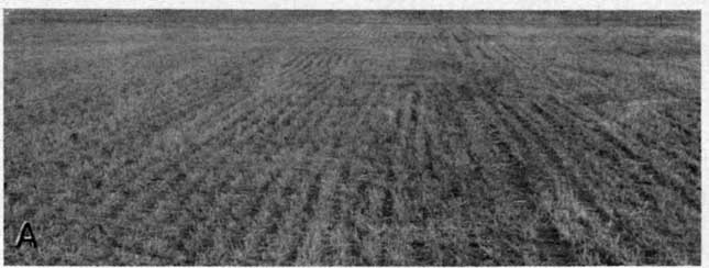
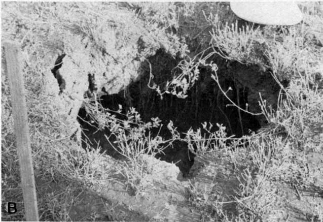
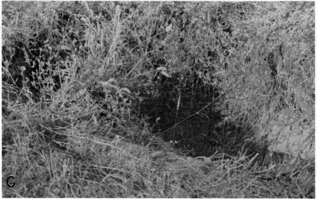
Plate 3--Differential silt infiltration sinks. A, Surface of Arkansas alluvial plain on which the sinks developed, near Hutchinson, Kansas. B and C, Sinks that have filled in to within a few feet of the surface; August 1948 (photographs furnished by Mr. T. J. Cambern).
On the alluvial plain of the Arkansas, and to a lesser degree the Smoky Hill Valley of central Kansas, numerous small inclosed depressions have formed since the areas have been under cultivation. Some of the larger basins have been attributed to a solution of subjacent Permian salt but the relation of others to the salt section and the history of their development exclude such an origin.
Data concerning a group of small sinks on the alluvial plain near Hutchinson were furnished to me by Mr. T. J. Cambern (of Howard, Needles, Tammen, and Bergendoff, Kansas City, letter dated Aug. 20, 1948). In this area, as in others, the small sinks have developed where the surface layer of alluvium is composed of silt, about 12 feet thick, which rests on well-sorted, unconsolidated sand and gravel. Rain water flows through openings which develop in the surficial silt so as to reach the sands and gravels below. This flow washes silt from the sides of passageways in the surficial material into the interstices of the coarser deposits beneath. Such inwashing of silt can continue as long as the passageways remain open or until enough silt has been carried into the coarse materials below to reduce their permeability and inhibit further inwash. After termination of silt inwash into the gravels the cavity is slowly filled and the initially steep sides of the sink reduced in slope. Localization of the initial point of inwash may be due to burrowing by rodents, decay of roots, or holes made by man. In the Hutchinson area the sinks were observed to be localized in an alfalfa field and were not found in adjacent wheat fields. As the water table in the area was about 15 feet below the surface, it seems probable that the dehydrating effect of alfalfa on the silt produced contraction joints which permitted inflow of rain water to the pervious sands and gravel below. The shallow root systems of wheat had little effect at depth.
It is possible that some of the depressions on the High Plains surface have been formed by differential silt infiltration, in spite of the greater thicknesses of sediment and greater depths to water table. During dry seasons sod cracks several inches wide have been observed on the High Plains surface and have been probed to depths of 5 or 6 feet. Coarse, pervious gravels are known to occur at many places below an upper layer of silt, and although it is not possible with available data to establish this mechanism as effective in upland areas, it should be considered a possible mode of origin of the basins in some places.
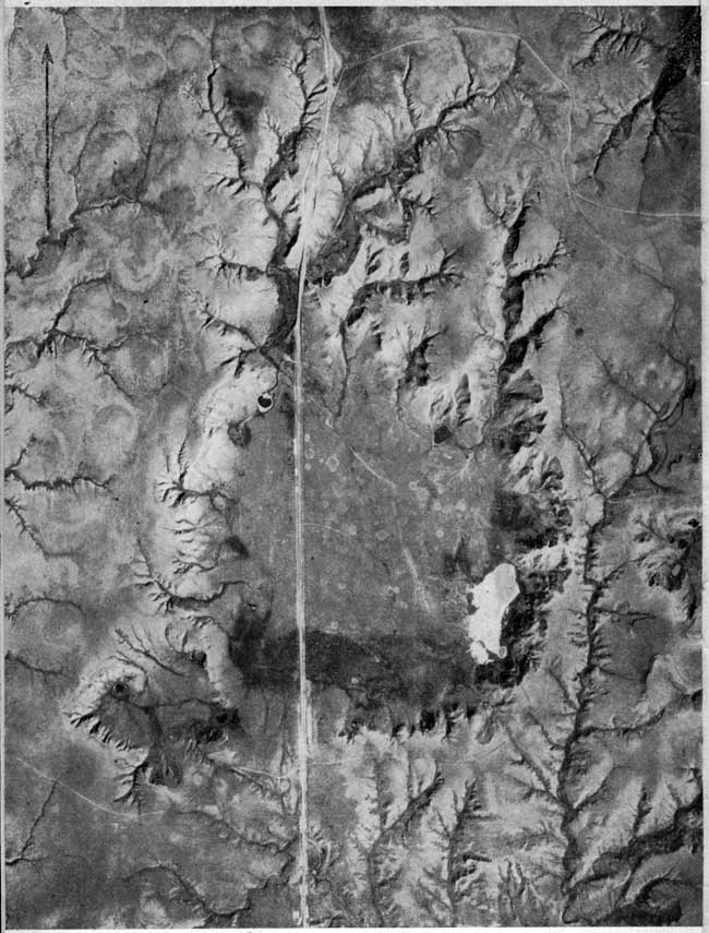
Plate 4--Aerial photograph of Big Basin and St. Jacob's well, in western Clark County, 1938. Photograph from U.S. Agricultural Adjustment Administration, reprinted from Smith, 1940, p. 239. These depressions are of the solution-subsidence type and are just north of the series of integrated basins making up the Ashland-Englewood lowland. A modern version of this photo is available.
Darton (1905, p. 36-37) referred to some of the depressions on the High Plains surface as "buffalo wallows" and explained their origin by the action of buffalos and wind. He believed the depressions were started by buffalos, either at wet, salty, or alkali spots, and that they were excavated by trampling hoofs followed by wind scour and also by mud sticking to the feet and shaggy coats of the animals during wet periods.
Although it seems quite plausible that the action of buffalos, as Darton describes, may have had importance in modifying or enlarging depressions, it could hardly have been effective in producing the initial low place that served to localize the wet spot, or other feature that attracted the buffalo. The effect of large animals, although possibly important locally in a secondary role, cannot be classed as a prime cause of Great Plains depressions. The effect of burrowing rodents in localizing rain water inflow, eolian scour, etc., may have been greater than that of the large animals.
Surface expression of faults is found in western Kansas only in Meade County. Faults cutting Permian and Cretaceous rocks are known to occur at many other places in the western part of the State and may have localized ground-water circulation and influenced the development of depressions, but fault scarps are commonly not reflected in the topography. In Meade County, however, the Crooked Creek fault (Frye, 1942) presents a distinct, though dissected, scarp along the east side of Crooked Creek Valley for about 15 miles and has less striking topographic expression on into Oklahoma.
It has been pointed out that the Crooked Creek and associated faults, by controlling the circulation of ground waters, have an important bearing on the development of solution-subsidence depressions in southwestern Kansas. The total movement along the Crooked Creek and Fowler fault planes occurred during early to middle Pleistocene time and they have importantly affected the topographic basin northeast of the City of Meade and the trough occupied by Crooked Creek south of that city. In these areas it is impossible to differentiate effects produced primarily by movement along faults from those formed secondarily by solution at depth. The topographic youth of the major fault scarp at some places is indicated by the series of minor stream piracies being accomplished along its crest and the close conformity of the scarp's position to the trace of the fault plane.
An area superficially suggestive of fault control is the elongate north-south trough through central Scott and northern Finney Counties (Latta, 1944; Waite, 1947; Schoewe, 1949). Test drilling (Waite, 1947) has revealed that the trough is a filled and abandoned early Pleistocene valley and that the secondary depressions, such as Modoc or Scott basin and Shallow Water basin, are developed in the Pleistocene sediments filling the abandoned valley.
A review of topographic depressions in the Great Plains of Kansas emphasizes that several modes of basin formation have been operative. Depressions developed in Permian or Cretaceous rocks (with or without an incidental veneer of Pliocene or Pleistocene sediment) seem clearly to be the result of solution of salt, gypsum, or chalk at various depths below the surface. Solution was followed by sudden collapse of surface rocks or by a slow progressive subsidence with downwarping of surface rocks. In central Meade County, subsidences may be due in part to movement along fault planes.
The smaller, shallower, but far more numerous upland depressions of west-central and northwestern Kansas are judged to be developed entirely in Pliocene and Pleistocene sediments by processes other than solution-subsidence. Depositional irregularities of late Pleistocene loess, in part controlled by pre-existing topography, wind scour, differential compaction in relatively thick loess blankets possibly controlled by former shallow valleys, and differential silt infiltration, may all have played a part. At least one large depression, Cheyenne Bottoms, may have been enclosed by eolian deposition on the surface of an alluvial plain. Action of buffalo and other plains animals, although not a prime cause of basin development, may have modified surface expression importantly.
Thus, western Kansas depressions may be arranged in two groups. The larger more striking basins are mostly solutional sinks. The smaller, more numerous basins are nonsolutional depressions.
Darton, N. H., 1905, Preliminary report on the geology and underground water resources of the central Great Plains: U.S. Geol. Survey, Prof. Paper 32, p. 1-433, figs. 1-18, pls. 1-72. [available online]
Elias, M. K., 1930, Origin of cave-ins in Wallace County, Kansas: Am. Assoc. Petroleum Geologists Bull., vol. 14, no. 3, p. 316-320, figs. 1-2.
Elias, M. K., 1931, The Geology of Wallace County, Kansas: Kansas Geol. Survey, Bull. 18, p. 1-254, figs. 1-7, pls. 1-42. [available online]
Evans, G. L., and Meade, G. E., 1945, Quaternary of the Texas High Plains: Univ. Texas, Publ. 4401, p. 485-507
Fent, O. S., 1950, Pleistocene drainage history of central Kansas: Kansas Acad. Sci. Trans., vol. 53, no. 1, in press.
Frye, J. C., 1942, Geology and ground-water resources of Meade County, Kansas: Kansas Geol. Survey, Bull. 45, p. 1-152, figs. 1-13, pls. 1-12. [available online]
Frye, J. C., 1945, Geology and ground-water resources of Thomas County, Kansas: Kansas Geol. Survey, Bull. 59, p. 1-110, figs. 1-13, pls. 1-6. [available online]
Frye, J. C., 1946, The High Plains surface in Kansas: Kansas Acad. Sci. Trans., vol. 49, no. 1, p. 71-86, fig. 1, pls. 1-3.
Frye, J. C., and Schoff, S. L., 1942, Deep-seated solution in the Meade basin and vicinity, Kansas and Oklahoma: Am. Geophysical Union Trans., pt. 1, p. 35-39, figs. 1-3.
Haworth, Erasmus, 1896, Local deformation of strata in Meade County, Kansas, and adjoining territory: Am. Jour. Sci., 4th ser., vol. 2, p. 368-373.
Haworth, Erasmus, 1897, Physiography of western Kansas: Kansas Univ. Geol. Survey, vol. 2, p. 11-49, fig. 1, pls. 1-8. [available online]
Johnson, W. D., 1901, The High Plains and their utilization: U.S. Geol. Survey, 21st Ann. Rept., pt. 4, p. 601-741.
Landes, K. K., 1931) Recent subsidence in Hamilton County, Kansas: Am. Assoc. Petroleum Geologists Bull., vol. 15, no. 6, p. 708.
Latta, B. F., 1944, Geology and ground-water resources of Finney and Gray Counties, Kansas: Kansas Geol. Survey, Bull. 55, p. 1-272, figs. 1-21, pls. 1-12. [available online]
Moore, R. C., 1926, The subsidence near Sharon Springs, Kansas: Science, vol. 64, no. 1649, p. 130-131
Schoewe, W. H., 1949, The geography of Kansas, part II, Physical geography: Kansas Acad. Sci. Trans., vol. 52, no. 3, p. 261-333, figs. 1-55.
Smith, H. T. U., 1940, Geologic studies in southwestern Kansas: Kansas Geol. Survey, Bull. 34, p. 1-240, figs. 1-22, pls. 1-34. [available online]
Waite, H. A., 1947, Geology and ground-water resources of Scott County, Kansas: Kansas Geol. Survey, Bull. 66, p. 1-216, figs. 1-16, pls. 1-16. [available online]
Previous--Deep-seated Solution
Kansas Geological Survey, Geology
Placed on web September 2005; originally published March 15, 1951.
Comments to webadmin@kgs.ku.edu
The URL for this page is http://www.kgs.ku.edu/Publications/Bulletins/86_1/page3.html