![]()
Prev Page--Introduction || Next Page--Upper Permian, Lower Cretaceous
Physiography of Western Kansas
by Erasmus Haworth
Drainage
Drainage in Tertiary Time
Character of the Materials Eroded
Methods of Erosion
Individual Streams
Cimarron River
Bear Creek
Arkansas River
Pawnee Creek
White Woman Creek
Walnut Creek
Smoky Hill River
Saline River
Solomon River
Republican River
In General
The Uplands
In Volume I of these Reports a short description was given of the more important physiographic features of the eastern part of the state. A like description for the remainder of the state is now contemplated.
Drainage
The surface drainage over eastern Kansas throughout earlier geologic times was westward, as the great body of dry land lay to the east. At the close of Cretaceous time the continent was elevated sufficiently to destroy the great inland arm of the sea reaching northward from the then Gulf of Mexico and connecting probably with the Arctic ocean on the north. The whole of the area lying between the dry land on the east and the mountainous ridge on the west thus became a dry land area, and its surface was subject to the erosive agents of the atmosphere.
It was at this time that the direction of the drainage was reversed. The great mountainous area was lifted sufficiently to produce a water shed to the east. The drainage from this crossed the great plains and entered the Mississippi river or the Gulf. In fact, it was about this time that the Mississippi, in the true sense of the term, became a river. The greatest of these drainage channels at present carrying waters from the Rocky mountains is the Missouri, into which numerous tributaries enter, so that more than half of the great plains area drains into the Missouri. In the northeastern part of Wyoming, and in Montana, the drainage is to the northeast. South from this in Nebraska and Kansas the drainage at present is almost straight east, while still further south it becomes deviated more toward the southeast. The waters from this part of the plains area enter the Mississippi directly through the Canadian and other channels without entering the Missouri. Still further south the drainage is into the Gulf of Mexico, either through the Rio Grande, or through lesser streams which enter the Gulf at different places in Texas. Comparatively few of these different streams rise in the mountainous country. The Missouri river with its more important tributaries, the Big Horn, the Yellowstone, the Powder, on the north, rise in the mountains; as do also the Platte river and the Arkansas in the central area; and the Canadian, the Pecos, and the Rio Grande farther south. The whole plains area, however, is covered with drainage channels, the most of which originate east of the foothills of the mountains. The ordinary map of the United States will show that the different streams are about as abundant over the great plains as elsewhere through the United States.
Of the Kansas streams as they now exist only one rises in the Rocky mountains—the Arkansas. Of the upper branches of the Kansas river the Republican rises farthest west. Different branches of this stream originate on the plains about one hundred miles west of the western boundary of Kansas. The tributaries of the Smoky Hill likewise originate across the line in Colorado, but not so far away. South of the Arkansas river the Cimarron river exists, which takes its rise from near Raton in New Mexico. In fact this stream almost might be called a mountainous stream, as its headwaters are away up on the highlands of the mountains. Lying between the Arkansas and the Cimarron is a little stream called Bear creek, which originates fifty miles or more west of the Kansas line.
At the present time many of these plains streams do not enter larger drainage channels. Having their rise in places where the inclination is relatively great, they frequently form channels from 20 to 50 feet deep, and prominent flood-plains, implying that they have a considerable age, but farther eastward simply spread out on the plains or into the sandhills. Bear creek, just mentioned, is a good example of this. In places its bluffs are 50 feet high and its flood plain valley is half a mile wide. Crossing the state line from Colorado into Kansas it reaches eastward to a point not more than eight or ten miles distant from the Arkansas river, where all traces of it gradually disappear. Not only this, but in times of freshets the water of Bear creek, instead of entering the Arkansas river as is so frequently represented on different maps, is spread out on the highlands area, none of which gets into the Arkansas excepting possibly an inconsiderable proportion which may work its way northward through the sandhills.
Other streams both north and south of the Arkansas have similar properties. The White Woman on the north is another good example. Rising a few miles west of the boundary of Kansas, it flows eastward for about seventy five miles. In places its channel is eroded to a depth of nearly 100 feet below the general level of the uplands, and a flood plain nearly a mile wide has been produced. In the vicinity of Scott City it gradually disappears, the bluffs and banks on either side gradually becoming less prominent, and finally no trace of the stream whatever can be found. In times of heavy rains large quantities of water are found in the stream which are emptied into a broad level basin near Scott City. The total number of such streams, big and little, has not been determined, but it is safe to say they would reach near a hundred were they all enumerated.
Drainage in Tertiary Time
During early Tertiary time the drainage seems to have been similar to that of the present. It is probable the climatic conditions were very different then from those now existing over the great plains. The vast amount of material carried eastward from the mountains and deposited in the plains from the Gulf of Mexico northward into Canada implies a correspondingly greater precipitation. There are good reasons, for believing the mountainous elevation occurred with relative slowness, but with considerable irregularity. The evidence of this on the great plains is confined principally to the character of the materials transported. In some places heavy coarse gravel beds were formed, the individual gravels in which frequently have a diameter as great as four or five inches, requiring a great velocity of water to transport them throughout the distance they have been carried. Above and below such gravel beds the material is frequently composed almost entirely of the finest sand, and clay, and silt, which strongly implies that the movement of the water at that time was not rapid, but rather that it was slow and sluggish.
As is shown later in an article on the physical properties of the Tertiary these heavy gravel beds and the beds of fine sand and clay alternate with each other showing conclusively that there have been recurrences of conditions, a rapid movement of the water being followed by a slow one, which in turn was followed by another period of greater velocities. It therefore seems that the terrestrial movements were such, either in the mountains or the eastern part of the plains area, that the velocities of the mountain streams were changing alternately from slow to rapid, and again from rapid to slow and sluggish. Evidence on this subject is reached outside of the great plains area, as has been shown by various authors in de. scribing the drainage and general geologic conditions of the great west. It is well established that the main mountainous area had a gradual elevation rather than a rapid one; gradual upon the average but one irregular in character, with different periods of rapid elevation intervening between long periods of slow upraising, or possible entire cessation in upward movements.
It is somewhat difficult to decide the exact geologic date of the accumulation of the Tertiary materials in Kansas. From paleontologic evidence it would seem that the oldest Tertiary horizon in the state belongs to a later Miocene period. Similar evidence gathered from the paleontologic history of the great plains to the north in the Dakotas shows that Tertiary material began accumulating there considerably earlier, in the Oligocene, or possibly in the latter part of the Eocene. We have corroborative evidence of this in Kansas. The upper surface of the Cretaceous has been gradually eroded and subsequently covered with Tertiary material. It appears that after the elevation of the mountainous area sufficiently to produce dry land through the western part of the state, and probably over the whole plains area, a sufficient time elapsed before the deposition of Tertiary material began to admit of erosion of the Cretaceous surface almost as extensively as that which is now observed on the surface of the Tertiary. Streams of different sizes existed in many places cutting their channels sometimes wide and deep, elsewhere to a milder degree, leaving a corrugated Cretaceous surface to be covered later by Tertiary materials.
If we accept the view, which seems to be established for the Dakotas, of the former existence of a northern Tertiary lake, the Sioux lake of King [Clarence King, U. S. Geological Exploration of the Fortieth Parallel, Vol. 1., p. 451, Washington, 1878.], it might seem reasonable to suppose that likewise the greater part of the Tertiary materials in Kansas were accumulated at the bottom of fresh water lakes. It is almost certain, however, that at least a considerable part of this material was deposited in place by rivers rather than in the bottom of lakes, and that therefore the different drainage channels which have existed since the beginning of Tertiary time in Kansas have migrated back and forth across the great plains, depositing different kinds of material in the irregular form in which we now find them.
It would be interesting to study the life history of these different streams, and to determine whether or not they were originally at all similar to the various streams crossing Kansas from the west at the present time. With the evidence already alluded to regarding the probable condition of drainage in the earlier Tertiary there is no special reason for not believing that the migration of the different streams has been sufficient in the aggregate to accomplish the main part of the results as we now see them. Should this be the case it is probable some of the erosion in the Cretaceous has taken place very recently. In fact, different ones of the lesser tributaries at the present time are cutting their channels into the Cretaceous throughout a part of their course and having their valleys filled in with Tertiary material from the adjacent bluffs in other places. It seems quite possible that some, at least, of the erosion of the Cretaceous may have occurred during Pleistocene and recent times.
Character of the Materials Eroded
The character of the materials in western Kansas into which the different drainage channels have been eroded differs greatly in different parts of the state; Throughout the western part over the areas covered with the Tertiary erosion could be produced very rapidly were the precipitation sufficient. Much more than half of the Tertiary material is in the form of loose beds of silt, or clays, or sand, or gravel, materials which would yield most readily to the corrosive action of running water.
Elsewhere the Cretaceous rocks are exposed to the surface, or have been so exposed. These in general would resist corrasion more vigorously than the Tertiary materials. In places, it is true, they are composed principally of shales which would yield quite readily. But elsewhere the limestone beds are so frequently interspersed with the shale that a relatively strong resistance to all forms of erosion would occur. It is quite probable that such formations have had a strong influence in producing the particular physiography of the country wherever they are exposed to the surface.
Eastward from the Benton and Niobrara exposures we find the Dakota covering the surface. In most places the materials of the Dakota are quite easily worn away. Consisting as they do of sandstone and shales, with the sandstone weakly cemented together, they offer but little resistance to the vigorous action of running water. In a few horizons the cementing material of the sands seems to be sufficiently strong to produce a tolerably strong sandstone, and therefore a material which will resist decay. It is a noticeable fact that the character of the river channels vary from place to place through their course, depending to a great extent upon the character of the material through which the channel is worn.
The residual materials found here and there through the drainage area corresponds in character quite closely with the materials into which the channel has been produced. Through the Tertiary area the most common residual products are sand and gravel. It is by no means unusual to find a small stream, or an arroyo, of only a few miles in length, in the Tertiary area which has carried away the clay and finer silt and has left behind as a complete mantle for its flood plain the sand which constitutes a portion of the original materials. Such sand washes are seen particularly in the southern part of the state through Meade and Clark counties, where the inclination of the surface to the south is so great that the streams have a correspondingly high velocity. Scarcely a creek can be found in this part of the state as much as five miles long, which rises in the main uplands of the Tertiary plains, that has not produced a channel from a quarter to a half mile in width in the lower part of its course. with the greater pact of the channel floor entirely covered by these residual sands, sometimes to a depth of 10 or 20 feet. The evidence regarding the origin of the sands in such a case is so apparent that little doubt can be entertained regarding it. On the higher uplands away from the drainage channels sand dune areas often are found miles in extent, the accumulation of the sands of which probably being of this same nature. Likewise gravel beds are frequently produced in the valleys of the arroyos and larger streams—beds composed of the residual materials left behind after the clays and finer sands have been carried away by the water of the streams. In many such cases it is easily seen that the gravels have been moved but a short distance from their previous home in the Tertiary formations.
Streams cutting their channels into the Niobrara and Benton limestones and shales leave but little residual materials in their course. The character of the limestones and shales is such that the erosive processes consume almost everything that is worn loose. Occasionally limestone boulders of various sizes are produced which are left behind along the valleys of the streams, but they are by no means common.
Eastward in the Dakota areas we have a condition similar to that in the Tertiary. The weathering action of the atmosphere and the abrasive action of running water have produced a large amount of loose Dakota sands, which are blown here and there over the valleys and flood plains of the different streams. In places on the high uplands where it appears the Dakota sandstone previously existed, it seems that it is largely crumbled to a loose sand which is scattered over the general surface, and blown by the winds into sand dunes and sandhills similar to those in the far west.
Methods of Erosion
Some of the present peculiar features of the erosive channels in the western part of the state are undoubtedly quite recent in origin. The climatic conditions are such that precipitation is greatly limited, and the ground is usually so thoroughly desiccated that but little moisture is found near the surface. The general shape, or appearance, of the immediate source of the various arroyos are in many respects different from any heretofore observed in other parts of the state, However, they are most nearly approached in the eastern part by the little ravines the immediate source of which is on a hillside where a relatively thin mass of limestone protects a heavy bed of shale. Under such conditions, even in a humid climate, the peculiar shape of the arroyos is similar to the commonly occurring forms in the western part of the state.
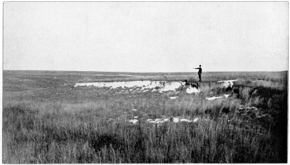
The main peculiarities referred to consist in the great width of the channel at its immediate source, and in the unusual abruptness of its banks. It is by no means rare to find an arroyo carrying a width of a hundred feet or more to its immediate source, so that the very uppermost part of it will simply be the upper somewhat rounded end of a plat a hundred feet wide. The banks on either side of such arroyos frequently are so abrupt that one can with difficulty ride across them. Plate I is made from a photograph representing the peculiar shape of such a bluff-line along an arroyo in Meade County, while plate II likewise represents the side of an arroyo in Meade County. This peculiar shape prevails everywhere in the west, not a single instance having been found of the ordinary V-shaped ravine so common in humid climates where soft materials are eroded.
Plate I—Source of an arroyo in the Tertiary of Meade County. (Photographed by Haworth, 1896.)
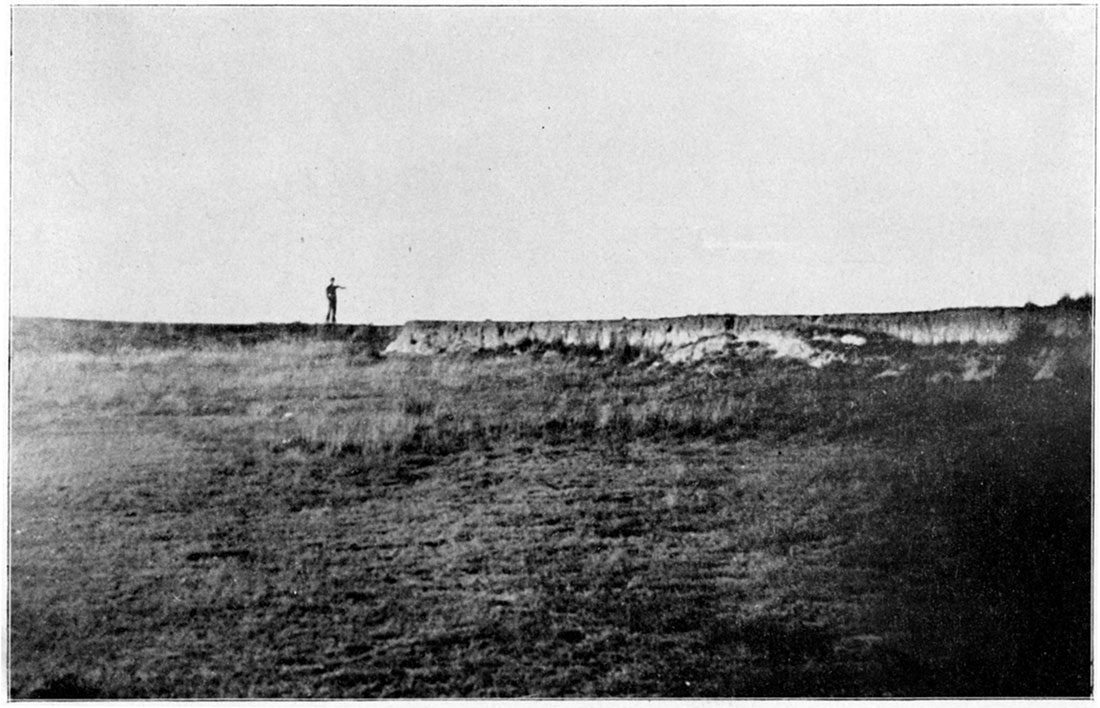
Plate II—Side wall of an arroyo in the Tertiary of Meade County. (Photographed by Haworth, 1896.)
The upper tributaries of the drainage channels in the west rarely have water in them more than a few weeks in the year. Therefore they evidently have not been eroded by the ordinary corrosive action of running water. This is further indicated by the fact that in nearly all cases the mat of grass covers the entire floor of the arroyo, the same as it does on the plains above. Such a covering of grass could not exist did erosion occur in the bottom of the arroyos at the present time.
The question may then well be asked: How were such channels formed? It has appeared to the writer that probably we have here an origin of drainage channels differing from that ordinarily produced elsewhere. It is certain that large quantities of material have been removed and carried downward by some process, so that ultimately they were carried away by the waters down stream where the currents are of some consequence. The vertical walls of the arroyos already alluded to seem to stand as indicators of the process nature has employed. May it not be that the principal part of erosion in the uppermost part of the arroyos has been accomplished largely by a slow creeping of the underground clays and soils immediately under the sod covered surface of the arroyo itself? During the rainy season the subsurface materials are saturated to a higher degree than on the main uplands. The inclination of the surface in such places is relatively great, frequently as much as thirty or forty feet to the mile. The sod of the buffalo grass on the surface is not broken through by what little water may flow during the rainy season, and consequently it will hold itself together and will not pass downward with any appreciable velocity. But immediately under the roots of the grass where the soil and the clay are kept moist during a considerable part of the year conditions are favorable for a rapid creeping of the materials in this particular part of the arroyo. Such a creeping would allow the mantle of sod gradually to settle downward, a settling extending itself finally to the outermost limits of the arroyo. The result would be that this blanket of sod would have an almost vertical movement and the steep and precipitous walls of the arroyo, frequently measuring from 3 to 6 or more feet in hight, would be a natural result.
If this explanation is correct, it is readily understood why the various arroyos should uniformly have so great a width at their source. The creeping process could be extended over the width of a hundred feet as readily as over five, and therefore the abruptness of the walls which is noted on the sides would also be produced at the immediate source, exactly as is shown in the plates already referred to.
Another feature of the Tertiary plains in the west which has attracted considerable attention is the frequent sinkholes, or swales, or lagoons, sometimes filled with water. The various topographic sheets issued by the United States Geological Survey have the greater number of these pools marked in blue lines, implying that they contain water intermittently. It has now been five years or more since any of them have held water for any continuous time. During July and August of 1895 they were nearly filled from the north side of the state to the south. But the water soon sank away, or was evaporated, so that they were entirely dry for perhaps eleven months out of the year.
In some parts of the state there seems to be no relation between these swales of various size and shape and the drainage channels. In other places there is an undoubted relation. Frequently an arroyo has been found heading toward a row of such swales. When we come to ask the question regarding the source of the swales we find it hard to answer. Different views have been expressed by different individuals. The one which the writer deems most probable is that they are located in places where the Tertiary materials were not quite as solid and firm as elsewhere, consequently, by the natural settling process, a difference in the surface was produced. As soon as such a depression was formed the rain waters from the higher grounds around would drain into it, and consequently a greater movement of water immediately under it would take place. This accumulation of water would dissolve and carry away by downward percolation a greater amount of matter than would be dissolved elsewhere. It is reasonable to suppose that in the deposition of the Tertiary sands and clays a somewhat heterogeneous character would be produced and that here and there would be streaks where the material would not be quite so firm as the average, and would consequently settle more irregularly. In this way would be formed a string of little swales which would become deeper and more pronounced as the solvent action was continued. An arroyo is only one step further. The continuous dissolving of the material under the swales would draw them nearer together and ultimately the barriers between them would be broken down and the arroyo would result.
Such a relation between the swales and arroyos is frequently noticeable in southwestern Meade County, perhaps more so than anywhere else in the state. It is frequently noticed that immediately above one of the upper branches of an arroyo a chain of swales is found reaching backward for a distance varying from a hundred yards to as much as half a mile. In such a case the relation is so apparent that it can not be doubted. The character of the walls of these swales is similar to that of the arroyos already described. A pond no more than thirty feet in diameter, with a buffalo-grass sod covering the whole of its bottom, frequently has a vertical wall from 6 to 12 or 18 inches high. At other times the wall is more rounded, but such a vertical condition is sufficient to recall the similarity between their character and that of the arroyos. If the explanation of the origin of the vertical arroyo walls is correct, this would be additional evidence in favor of the solvent action of the water in the swales being one of the causes in their production. The buffalo grass would be held in place on the surface of the bottom of the swale and of the arroyo, and as the material was dissolved from below the whole of the sod mantle would settle downward in a manner similar to the mantle of buffalo grass in the arroyos.
The swales are most abundant on the high uplands where the Tertiary materials are the heaviest. Usually there seems to be no relation between their respective positions, but not always so.
Individual Streams
We will now give a short discussion of the individual streams of western Kansas.
The Cimarron River
The Cimarron river rises near Raton, N. M., and flows eastward through southern Colorado and the southwest part of Kansas, ultimately emptying into the Arkansas river. In Kansas it has water in it throughout the greater part of the year in most of its course. It usually has a rise during the summer season at about the same time the Arkansas rises from melting snows. A considerable portion of the water in the river during the dry parts of the year is obtained from seeps and springs fed by the general underground water of the Tertiary areas.
The valley of the Cimarron where it enters Kansas on the west is not very pretentious. The bluffs on either side of the stream are rounded rather than abrupt, and rise to a hight of from 100 to 150 feet. The valley itself will average perhaps no more than a mile in width throughout Morton, Stevens, and Grant counties. Farther east it widens somewhat, so that in southwestern Meade County it is nearly two miles wide. The general character of the bluffs likewise changes, becoming more abrupt. This is probably due to the greater hardening of the "mortar beds" near the surface throughout the greater part of Seward County. At Arkalon and a few miles above and below the bluffs are exceptionally abrupt and the valley is entirely cut down into the broad, fiat Tertiary plains. The "mortar bed" rocks are prominent along the bluffs near the summit, producing a very picturesque appearance. Perhaps no river valley in the state, or in the world, as for that matter, is more nearly a channel cut downwards with almost vertical walls into a broad flat plain. The "mortar beds" near the surface serve as a protection which prevents the bluff-lines from assuming the customary rounded form of erosion.
The Little Cimarron river is a tributary to the Cimarron river, rising a short distance across the state line in Colorado. Throughout Morton and Grant counties its course is almost parallel with that of the Cimarron river. It rarely has water in it during any considerable portion of the year, and is entirely unaffected by melting snows in the mountainous regions. It has a wider valley than the Cimarron does throughout the part of its course where the two are parallel. In Grant County its valley will average about two miles wide, while in Morton County it is but little less. The bluff lines along this tributary correspond very well with the bluff lines along the Cimarron in Morton and Grant counties, but possess none of the abruptness so prominent along the Cimarron river in Seward and Meade counties.
Bear Creek
The general characteristics of this little stream have already been given. Its peculiarities consist in the deep channel it possesses in the western part of its course, and the absence of any channel whatever in the northern part of Grant County. It is an excellent example of the short streams so common in western Kansas which have a well defined channel and valley through their upper course but which reach eastward to a plain of less inclination through which they have no channel whatever.
During times of heavy rains in eastern Colorado and western Kansas Bear creek carries a large volume of water, which it pours out upon the high plains of northern Grant County, and into the sandhills along the south side of the Arkansas river. In order to give the reader a fair idea of the character of this little stream during such freshets, and of its disposition of the water it carries, quotation will be made from a letter received from Judge W. E. Hutchinson, descriptive of the time of high water in July 1895. [This letter was written for a preliminary Report to the State Board of Irrigation, and will appear in their final Report.]
"During the night of the 19th of July 1895 the water raised in Bear creek about the line between Grant and Stanton counties and proceeded slowly towards the end of the channel in the edge of the sandhills near the Arkansas river south of Hartland. The amount of water was such as could be retained within the channel of the stream and not more than has often been seen in the channel of this creek once every two or three years. By the morning of the 21st of July the water had almost subsided, but it was reinforced by the heavy rains in Colorado, and commenced to rise again on the 21st of July and continued to run until the 25th of July. From the places where it broke out from the channel, most particularly which were near the Grant and Stanton county line, the water flowed in northeasterly and southeasterly directions out upon the highlands. The average depth in the bed of the stream was about 6 or 7 feet; that on the highlands would average about 12 inches. It spread out on each side of the stream one and one half to three miles, carrying with it drift of all kinds that passed down the channel, particularly grass, weeds, sage brush, etc. It seemed to run over the highlands as if in a newly made channel. The overflow in a southeasterly direction near Shockeyville, Grant County, continued as in a channel in which the current was very apparent for eight or ten miles, spreading out on either side of the well defined and recognized center, or channel. The velocity in these channels out on the highlands was nearly equal to that in the main channel for a distance,—it was at least on an average from a mile and a half to two miles an hour; the velocity of the water in the main channel was probably three miles an hour. Bear creek has a well defined channel from the state line to the sunk well at the south side of the sandhills, seven miles south of Hartland. This well, which is simply a depression in the sandhills, and in coarse sand, was never known to have been dry until about two years ago. The level of the water, however, in this depression is usually about 6 feet below the bottom of the channel at that place. From the sunk well on through the sandhills is a winding channel which one would scarcely think was intended foe a channel of a stream until he should see water coursing through it, as we did this summer. The water ran past the sunk well, the usual terminus of the stream in times of ordinary floods, clear through the sandhills to the last ridge of them next to the Arkansas river, through which ridge there seems to be no opening whatever for its escape. It spread out east and west in irregular shapes, as it could find openings between the ridges of the hills, for probably a mile and a half or two miles wide, and it is safe to say was in some places 15 to 20 feet deep, as is now made very apparent by the marks washed out and the drifts left on the sides of the hills. Not a drop of the water escaped into the Arkansas, and after the 25th of July when the flow down the channel ceased, the water stood and remained in the channel and elsewhere in the sandhills, the same as it did in the basins and lagoons on the uplands. It was not long, however, in drying up in the main channel of the stream. Out on the uplands, especially in basins, the water stood for several weeks. In the sandhills there is water standing now (Dec. 27th 1895) in some places. Eleven years ago there was a similar overflow of Bear creek which spread over the uplands, we are told by the cattlemen who were then in the country, and ran past the sunk well into and nearly through the sandhills as at this time."
The Arkansas River
This stream rises in the mountainous areas of Colorado, flows eastward through a portion of Kansas, and finally reaches the Mississippi. It crosses the western line of Kansas at Coolidge near the middle of the Hamilton County line, or about seventy two or seventy three miles north of the south line of the state. Here it flows east southeast to Hartland, thirty five miles within the state, at which place it bends considerably to the north to the east line of Kearney County, twenty miles away. From here it travels east southeast about eighty miles to near the eastern line of Ford County. At this point it is within forty five miles of the south line of the state. Here it bends decidedly to the north and travels in a northeasterly course to Great Bend, about forty miles east and forty miles north. Making a bold curve at Great Bend it bears to the southeast and finally more to the south, passing out of the state at Arkansas City about one hundred and twenty five miles west of the southeast corner of the state.
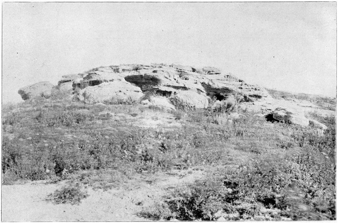
Throughout its course from Coolidge to the eastern side of Ford County the river has a valley or flood plain which will average about three miles in width. See plate III. The valley is limited on the north by a tolerably abrupt bluff line, which is very pronounced throughout this whole distance, excepting for a few miles in the vicinity of Garden City. From Coolidge to near Hartland the north bluff is composed of Benton limestones and shales. Below Hartland it is composed of Tertiary materials. The "mortar beds" are so pronounced throughout the greater part of this distance that they offer a strong resistance to erosion, and result in the production of unusually abrupt bluffs. See plate IV. Frequently the "mortar beds" are most prominent near the top of the bluffs, but it is not unusual to find them well cemented throughout almost the entire hight of the bluff. In such cases they do not constitute the whole of the bluff, but two or three or four strata of coarse sand or gravel exist with clay partings between varying from 5 to 20 feet in thickness. The coarse sand and gravel is almost invariably cemented by calcium carbonate so that a tolerably firm rock mass is produced which resists decay and helps to produce the abrupt character of the bluffs.
Plate III—Along the Arkansas River, near Dodge City. (Photographed by Haworth, 1896.)
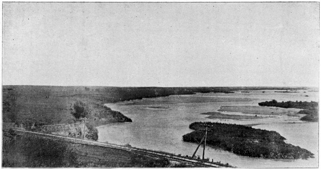
Plate IV—Tertiary "Mortar-Beds" bluff near Dodge City. (Photographed by Haworth, 1895.)
In the vicinity of Garden City there seems to be an old drainage channel entering from the north, a channel which is popularly believed to connect with the White Woman area in the vicinity of Scott City. As this part of the country north of the Dodge sheet area has not yet been covered by the U. S. G. S. topographic survey we are in doubt regarding the exact conditions of elevation. It can be seen, however, by riding across the country that there is at least an approach to an old valley, and in certain parts of the distance it looks as though little doubt could be entertained regarding the former existence of an old channel from the north into the Arkansas near Garden City.
From the eastern part of Ford County to the vicinity of Larned but few if any bluff lines are noticeable on the north side of the river. Here the Dakota sandstone caps a hill of sufficient prominence to be noticed in the landscape which has received the name of Pawnee Rock, in commemoration of an important historical event in connection with the Pawnee Indians said to have occurred at this place. From Larned to beyond Great Bend the Dakota sandstone and the Benton which overlies the Dakota form considerable bluffs some distance back from the river. As the river bears to the east and finally to the southeast near Great Bend, the width of the valley between the river and the Cretaceous bluffs greatly increases. For some distance below Great Bend to the vicinity of Wichita, and in fact throughout the remainder of the state, there is but little demarcation of the river valley or flood plain, the whole area being one great expanse of level country on both sides of the river, scarcely relieved by any upland areas of noticeable prominence.
On the south side of the river from Coolidge to Great Bend the conditions in the main are quite different from those on the north. A row of sandhills limits the river valley on this side throughout the entire distance. The actual elevation of the sandhills and the plains beyond is as great upon the average as the high uplands to the north of the river. In fact, the sandhills themselves are usually a little higher than the plains to the south of them, as though in some way they had been elevated above the surrounding country. The width of the sandhills is variable, in some places being no more than three or four miles, while elsewhere they stretch away to the south fifteen or twenty miles. Such an unusual southern extension occurs in the southern part of Finney and the northwestern part of Haskell counties where the sandhills reach almost to the Cimarron river. Again in the eastern part of Haskell County another long southern extension may be noticed, which extends from ten to twelve miles south of the river. Beyond the eastern limit of Ford County the sandhills become less prominent, but are very noticeable all the way from near Bucklin to almost opposite Great Bend, where they gradually disappear, or become less pronounced in elevation above the surrounding country. From Great Bend to Wichita, and from Wichita to Arkansas City, the whole area on the right bank of the river is covered with an exceedingly sandy silt which here and there is blown into a series of sand dunes somewhat approaching in character the sandhills further to the west, but no where equaling them in magnitude.
The Arkansas river valley has been much deeper at one time than it is at the present. The filling in process has been in operation for a sufficient length of time to fill the channel of the stream to a level with its flood plain, and doubtless raised the general level of the flood plain very appreciably. So few wells have been sunk in the valley entirely through the river sands that we are almost entirely uninformed regarding the character of this earlier river channel. At Coolidge the artesian wells which have been drilled showed that the river valley was probably less than 50 feet in depth. Great effort was made to obtain an accurate record of one of the wells, but no such record could be found. It is currently reported by the citizens of Coolidge that the stratified material is generally found in the valley at that place at a depth not exceeding 35 to 50 feet. Eastward from Coolidge and Syracuse no information is obtainable on the subject until Garden City is reached. At this place in the summer of 1888 a deep well was bored nearly half a mile northwest of town to a depth of 1000 feet or more. No resident of the place could be found who had kept an accurate log of the well. By an examination of the old files of the "Garden City Sentinel," however, it was learned that that paper published on April 18, 1888, a log of the well to a depth of 550 feet, as follows:
| Soil | 12 feet |
| Quicksand | 299 feet |
| Black slate | 150 feet |
| Sandstone | 5 feet |
| White slate | 10 feet |
| Black sand | 5 feet |
| Soapstone | 69 feet |
| Total | 550 feet |
From this it would appear that the river sands were reached at the surprising depth of 311 feet. It is difficult to understand how such a great depth could exist here with so shallow a covering of sand in the valley at Coolidge less than seventy five miles above.
Below Garden City no further evidence is available until Great Bend is reached. Some years ago a deep well was put down three or four miles to the northeast of town, but still within the river valley, in search for fuel. No absolutely accurate log of this well was kept, but it is tolerably certain the river sands at this place are no more than 80 or 90 feet thick. As the well was located some distance back from the present river channel it is quite possible they were shallower there than in the deepest part of the river valley. From Great Bend eastward nothing more is obtainable until the salt wells of Sterling, Nickerson, and Hutchinson are reached. The logs of various wells in these localities have been examined, not one of which showed a thickness of sand more than 100 feet, and the greater portion of them showed the sand to be from 70 to 90 feet in thickness. At the present time a deep well is in process of construction at Wichita. Samples of material from it have been preserved in glass bottles and are open for examination. They have been partially studied and seem to show that the stratified material was reached at the depth of about 150 feet.
Taking all these facts into consideration, it makes it seem exceedingly doubtful about the river channel ever having been as much as 300 feet deeper than it is now in the vicinity of Garden City, although one cannot positively dispute this record. We have ample evidence, however, for stating that the river valley at one time was from 50 to 100 feet deeper than it now is, and that at the present time a filling-in process is in operation.
Within the last fifteen years a very noticeable filling in of the river channel has occurred. The various bridges which are built across the river at different places when constructed from eight to twelve years ago were usually built high enough so that a man on horseback could easily ride under them while sitting erect. At every bridge along the river the sands have accumulated until the most of them are not more than from 3 to 6 feet above the top of the sands. Such an accumulation of sand is in no way due to the presence of the bridge, as the sand level under the bridge is the same as that both above and below.
Throughout the greater part of its course in western Kansas it seems that the recent filling in process has been principally on the south side. A typical illustration may be taken from the river at Ingalls. The bridge there was built in 1886, twelve hundred feet long. At that time the main current of the stream was just to the south of the present (1896) south end of the bridge. Southernly winds and the river currents during times of overflow have filled in the bottom to the south of the bridge so that the bottom land has been carried far to the north. Several hundred feet of the south end of the bridge have been taken up, and the area occupied by the main river channel in 1886 is now a cultivated field.
The river valley throughout its entire course has marks of many old channels in it similar to the conditions so frequently noticeable elsewhere after a river has reached its base level. The stream has shifted from bluff to bluff along its channel many times, during which time it has been gradually building its flood plain higher.
Throughout a portion of its course the Arkansas river seems to flow on the summit of a ridge. The general elevation of the country at Coolidge is perhaps a little lower than the surface either north or south. In the absence of topographic surveys, however, one is liable to err in his estimates. The elevation of no point south of Coolidge has yet been determined, while to the north we must go to the Missouri Pacific railway in Greeley County twenty five miles away. The elevation of Horace, a point fifteen miles farther east than Coolidge, is 3643 feet, while that of Coolidge is only 3341 feet, making Coolidge, or the Arkansas river valley, about 300 feet below these uplands. The bluffs at Coolidge are no more than 100 feet high, and probably less, making the general elevation of the uplands at Horace nearly 200 feet above those just north of the river. At Garden City the elevation in the river valley is 2827 feet, while thirty five miles to the north Scott City is 2771 feet above sea level, showing the decline of the surface eastward along the Missouri Pacific railway is more rapid than that along the Arkansas. The old river valley at Garden City is therefore higher than the main uplands at Scott City. As we move east this difference is still more noticeable. The elevation of the river valley at Dodge City is about 2440 feet, while the high bluffs to the north are 2600 feet high. Immediately north, at Ness City, the elevation is only a little more than 2200 feet, making the river valley at Dodge City more than 200 feet above the Walnut valley at Ness City, fifty miles to the north. The elevation of the Buckner a little west of Jetmore is about 2300, showing the decline from Dodge to Ness is gradual. It would therefore seem that the Arkansas river from Garden City to Dodge at least is occupying much higher ground than that which lies to the north. South of the river, however, the general elevation is about the same, or a little greater, than the river until the central part of Haskell and the southern part of Gray and Ford counties is reached, from which line the surface drops rapidly towards the southeast. Below Dodge City there is not so much difference in elevation between the river and the adjacent country.
These conditions can be tolerably well determined by an examination of the ordinary map of the state. It will be seen that from Coolidge to near Garden City the general drainage of the country is towards the Arkansas river from both sides, although but few of these lesser tributaries actually enter the river, as the most of them simply spread out in the broad valleys. Below Garden City almost no drainage from the south enters the river, while from the north the upper tributaries of the Sawlog and the Buckner rise within a few miles of the bluffs of the Arkansas. By an examination of the country itself one will be surprised to find that many of these lesser arroyos have their source within less than a mile of the brink of the bluffs on the north side of the river from Dodge City towards Garden City. Below the bend in eastern Ford County the drainage again becomes more natural, and the Arkansas has tributaries entering it from both sides, showing that it no longer flows along a ridge.
One of the most noticeable features in connection with the Arkansas river is the great and unusual bend it makes in passing from eastern Ford County so far to the north to Great Bend, and back so far to the south. By an examination of the geologic map it will be seen that in eastern Ford County the Dakota is exposed at the surface, and that a strip of it extends eastward from this place continuously to below Great Bend, The country to the south of Great Bend in Edwards, Pratt, Stafford and Reno counties is covered with a sandy accumulation strongly resembling the general river sands. It would seem that when the river reached the Dakota formation, a formation so easily corroded, it immediately began acting upon it with great vigor. As the general inclination of the strata of the Dakota is to the northeast it follows that a given geologic horizon is considerably higher in eastern Ford County than the same one in southern Barton County at or near Great Bend. The evidence is so striking that it would seem the cause of the river's great bend to the north is the existence of the easily corroded Dakota sandstone. We may therefore believe that at an earlier period in the history of the river it passed eastward from Ford County across the north of Kiowa, Pratt and Kingman counties, probably passing out of the state not far from its present location.
If this explanation is correct, one can not help inquiring why the river did not break through the uplands in the vicinity of McPherson County and ultimately join the Cottonwood river through Marion and Chase counties. To answer this dearly we only have to look at the general geologic character of the southern part of the Permian in Butler and Cowley counties to find an adequate reason. The great Flint-Hills area described in Volume I of these Reports has its surface rising to points considerably higher than the main uplands of Sumner and Sedgwick counties. Evidently these high elevations in the early Tertiary times deflected the river southward and prevented it from crossing the Flint-Hills region when the drainage was first changed to an easterly direction by the elevation of the mountainous area. The same Flint-Hills area has continuously remained higher than the uplands in Sumner, Sedgwick and adjoining counties. Therefore, with the river once flowing out of the state near where it now does it would be impossible for it to pass eastward across the Flint-Hills so long as the elevations remain as they now are. In the course of its corrosion when it finally reached the Dakota sandstone the cutting away of the Dakota material would be a natural consequence, and the great bend in the river would thus be produced.
Along the western part of its course the stream is held in place by the relatively firm Benton limestones and shales from Coolidge to near Garden City, so that the migration of the stream northward down the gentle inclination of the bedding plains of the Benton is an exceedingly slow process, and therefore not very prominent. Likewise the unusually strong cementation of the "mortar beds" in Finney, Gray, and Ford counties on the north side of the river have served as a check to the northern migration of the stream in this part of the country. What has likewise helped in this matter is a relatively high ridge of the Benton extending westward from Jetmore up the Buckner and the Sawlog, so that we have a ridge of Benton limestone which strongly resists decay, which has probably served to assist in preventing the river from migrating northward in Gray and Ford counties. But when the eastern limit of Ford County is reached no further obstruction was placed to the northward migration of the river. The upper channel being held in place from Coolidge to Dodge City, and the lower channel being held in place in the vicinity of Arkansas City and Winfield, and no restraints being placed upon the river throughout the interval it would follow in the process of its corrosive actions the path of least resistance, and would therefore migrate northward with the gentle inclination, of the bedding plains of the Dakota sandstone. This northward migration probably continued until the condition of base level was reached and the filling in processes began, after which the stream was unable to corrode the Dakota bluffs from Larned to beyond Great Bend, and consequently its northward migration has ceased.
Pawnee Creek
The Pawnee is a small stream draining the country north and northeast of Dodge City, and south of the Walnut. It enters the Arkansas river at Larned. It has an unusually large number of tributaries which cover an area of fifty or sixty townships to the north of Dodge City. Its upper branches rise in the Tertiary, but they soon cut their channels through the Tertiary to the Benton limestones and shales. In this way they drain the Tertiary ground water and are supplied with running water almost the entire year.
The Pawnee in this respect is much more fortunate than many larger streams.
Another peculiarity of this stream is that its uppermost tributaries on the south drain the country to within a mile or two of the Arkansas river, as already explained when discussing the Arkansas. The larger tributaries, the Sawlog, the Buckner, and Pawnee fork itself, have worn channels from 50 to 100 feet deep, and in most places have valleys which are from half a mile to a mile in width. The Buckner is particularly noted throughout the upper portion of its course above Jetmore. It has very abrupt bluffs on either side, capped with unusually firm "mortar beds" material of the Tertiary formation. In this respect it simulates in general appearance the larger streams.
Farther east, beyond the junction of the Pawnee fork and the Buckner in Pawnee County, the bluffs are less abrupt and the valleys less distinct from the uplands. In this respect it corresponds to the valley of the Arkansas as already described. The country occupied by Pawnee and Edwards counties is a broad, almost level sandy plain with only a gentle inclination to the east, while farther west along the headwaters of the Pawnee the inclination is sufficient to cause decided erosion.
The White Woman
The White Woman is a stream which rises in Colorado twenty miles or more beyond the state line and flows eastward to Scott City, at which place it entirely disappears, not emptying into any other stream. Throughout its course in Greeley County and the western part of Wichita County it has a decided channel, often with bluffs from 40 to 75 feet high, and a valley from a quarter of a mile to nearly a mile in width. The general inclination of the surface of the country towards the east is fully ten feet to the mile, and probably more. As Scott County is approached, however, the inclination of the surface declines until the vicinity of Scott City is reached, at which place it is almost entirely level. There seems to be a ridge, a sort of underground Cretaceous swell, to the east of Scott City, which has probably affected the action of this stream. At any rate its bluffs and banks disappear, and it empties its water in times of flood into a broad flat area called the Basin. This basin in reality in dry times seems to be only a broad flat part of the country with no special boundaries that one would notice, excepting when it is covered with water.
There are a few smaller streams lying between the White Woman and the Arkansas, most of which are locally known as Sand creek. They occupy the uplands in the north of Kearney and Hamilton counties, one of which rises across in Greeley County. They are similar to the White Woman in that they have no connection with other streams, but simply pour their water in times of flood out upon the broad plains of northern Finney and northeastern Kearney counties.
Walnut Creek
Walnut creek is a stream rising in Lane County near Dighton and flowing east through Ness and Rush counties and entering the Arkansas river three or four miles below Great Bend. It drains a strip of country about twenty five miles wide through nearly all this distance. It rises in the Tertiary area of Lane County, but soon reaches the Niobrara chalk beds in Ness County, into which it and its tributaries cut deep channels. Farther down in Rush County it passes over the Benton, and finally reaches the Dakota in Barton.
One of the most remarkable features of the Walnut is its surprisingly wide valley. Throughout all its course from the eastern part of Ness County it has a valley that will average nearly as wide as that of the Arkansas. The bluff lines on either side are exceedingly varied, depending upon the character of the material into which the valley is cut. Eastward in the Dakota area the bluff lines are rounded and relatively mild. In fact, the valleys of the Walnut and Arkansas coalesce several miles above Great Bend, so that throughout at least ten or more miles of its course the Walnut has no bluff lines, but simply follows its little channel through the general valley to its confluence with the larger stream. In Rush County and eastern Ness County where the Benton material is exposed along the bluffs the valley is limited by the relatively high and abrupt bluffs. Frequently they will reach the hight of from 75 to 100 feet in the western part of Ness County and the eastern part of Lane County. Where the various tributaries of the Walnut have cut their channels in the Niobrara chalk the valleys are narrower and the bluff lines very abrupt, often almost precipitous, producing thereby a picturesqueness scarcely surpassed by any one of the streams in western Kansas.
Smoky Hill River
The Smoky Hill river is one of the principal tributaries producing the Kansas river. By its junction with the Republican at Junction City the Kansas is formed.
The Smoky Hill rises in Colorado only a short distance beyond the western Kansas line. From the west side of the state to as far east as Salina it has a great many lesser tributaries, none of which are of particular importance. At Salina the Saline river enters from the north, and at Solomon the Solomon river likewise enters from the north. Each of these will be considered separately. Through the western part of the course of the Smoky Hill its lesser tributaries rise in the Tertiary formation. The larger ones, however, and the main channel itself, have cut through the Tertiary to the Cretaceous, so that the main part of the Smoky Hill flows on a Cretaceous floor continuously from the western part of the state to Salina, from which place it rests on a Permian floor throughout the remainder of its course to Junction City.
This series of geologic strata through which it has cut its channel gives a variety of conditions regarding the water content of the stream. Invariably where a stream rises in the Tertiary and has just cut its channel to the Cretaceous floor below, or almost to the Cretaceous floor, it is supplied with seeps and springs so that it carries never failing water. The upper tributaries of the Smoky Hill therefore in most cases have water in them throughout the entire year. They are fed by seeps and sometimes by springs which never fail. Such geographic terms as Russell Springs and Sharon Springs imply the presence of springs of considerable importance. But farther east where the channel is worn a considerable distance into the Cretaceous, a formation which produces no water whatever of any consequence, the evaporative forces of the air and sun's rays generally have evaporated all the water in such streams. We have the anomalous condition, therefore, particularly along the Smoky Hill river and its tributaries, of a stream which is well supplied with living water in the upper part of its course having little water in it farther below, they being entirely dry throughout a considerable part of the year, but still farther down being rarely without water. East of Russell County a new condition is met with, the presence of the Dakota sandstone. The tributaries in this area likewise are moderately well supplied with springs and consequently pour considerable water into the Smoky Hill river, so that throughout its lower course it is rarely if ever dry.
The channel of the Smoky is perhaps the deepest of that of any stream in the state. Through a large part of its course in Gove, Trego and Ellis counties the main uplands on either side are from 300 to 400 feet above the valley of the stream itself. The bluff lines are generally not as abrupt as those already described for the Cimarron river in the vicinity of Arkalon, or those for some other streams, but have been somewhat more eroded and have the rounded form so common in old age. The great depth of the channel, however, has caused all the lateral tributaries likewise to cut deep channels, so that the country on either side of the river for from two to four miles back is so hilly that it is difficult to travel in directions parallel with the stream.
Farther west, in places where the main part of the bluffs is composed of Tertiary materials they are correspondingly less rugged and the channel to the west gradually becomes shallower. In Gove and Trego counties and the western part of Ellis County the rocks through which the channel is cut are the Niobrara chalk beds. These have yielded to erosion apparently with great ease, but being relatively uniform throughout the general character of the hills and hillocks produced is different from that commonly observed where hard and soft materials are in alternating strata.
The valley, or flood plain of the Smoky Hill river is not very wide throughout the greater part of its course. But few places west of Ellsworth can be found where the flood plain is more than a mile in width, while in many localities it is narrower. Neither is the river valley extensively filled with fluviatile debris, as has been seen to be the case in the Arkansas river valley. In most places over the flood plains of the Smoky one can dig in the river sand only a few feet, rarely over 20, until the solid Cretaceous floor is reached. The river channel itself in many places exposes the Cretaceous. These conditions show that the river has scarcely yet reached its base level. Probably in a considerable part of its course it is still deepening its channel. From the vicinity of Salina eastward, the condition of base level has doubtless been reached for some time. The unusually wide valley at Salina and the relatively wide valley from Salina eastward imply a much longer period for widening the channel than has existed farther to the west.
The particular direction of the river in places is of great interest. Nothing of special importance is noticed in this connection above Ellsworth. But from Ellsworth to Salina the course of the stream is quite remarkable. At Kanopolis a great ox-bow form reaches to the south a distance of three miles, while just east of Kanopolis a similar ox-bow carries the river to the north. Such ox-bow forms are repeated to the eastern side of Ellsworth County. As best one can judge from examining them on the map these forms are in every way similar to the ox-bow forms produced by a stream meandering across its flood plain after it has reached base level.
The cause of such forms has not yet been determined. Possibly they are due to the shape having been assumed in earlier times when the elevation of the western part of the great plains area was so limited that the stream had a sluggish movement and meandered as though it had reached base level. Possibly it is due to the peculiar variation of the hardness of the formations through which the channel is cut, and its consequent variable ability to resist decay.
From the eastern line of Ellsworth County the river bears still further to the south until a point near Lindsborg is reached where, with a bold curve, it passes to the northeast and north by way of Salina. From the Ellsworth County line eastward the valley gradually becomes wider. At Marquette it is about two miles wide, at Lindsborg it is nearly four miles wide, at Bridgeport it is approximately six miles wide, while still further down in the vicinity of Mentor and Salina it is eight or nine miles wide. The peculiarity of direction from Kanopolis to Lindsborg may possibly be due to the extraordinary thickness and hardness of the Dakota sandstone immediately east of Kanopolis for a distance of twelve or fifteen miles. The general conditions of the country imply that for some reason the sandstone was less resistant to erosion southward than in the vicinity of Terra Cotta, and that consequently the river worked its way eastward where the resistance was less marked. Reaching the vicinity of Lindsborg we find Dakota sandstone immediately east of the direction of the river. As the whole of the Dakota is swept away from the broad valley between Lindsborg and Salina, it is impossible to conjecture what the character of it was. Possibly here it was less resistant than farther to the east. This explanation is assuming unusual variations in a mass of sandstone covering the country from twenty to thirty miles. Still it is possible. Aside from this possibility at the present time no observations have been made which throw any light on the question of the peculiar direction of the Smoky Hill river between Ellsworth and Salina.
Later in this report is a discussion by Mr. Beede of the old river channel now occupied by the McPherson Equus beds. In that connection will be found a discussion of the probability of the Smoky Hill river formerly having flowed southward from near Lindsborg connecting with the Arkansas rather than to have flowed northward and ultimately become a part of the Kansas river. It is there shown that great obstacles are encountered on such a supposition, but that the true explanation of the existence of the Equus beds has not yet been discovered.
From Salina to Junction City the direction of the Smoky Hill is apparently normal. The valley from Salina to Solomon is from three to four miles wide. Beyond Salina the bluffs are relatively unimportant to below Abilene, from which point they begin to appear on either side of the stream, and are quite prominent downward to Junction City. The probable cause of the absence of pronounced bluff lines from Salina to below Abilene is the particular character of the material into which the channel is cut. Here we have the last remnants of the Permian exposed to the surface at the eastern part of the lowermost portions of the Dakota, a kind of material which is relatively soft and comparatively uniform throughout, so that the conditions are most favorable for the rapid erosion and the gradual wearing away of the bluff lines until they are unimportant.
The river from Salina downward has an unusually larger number of bends as it meanders from side to side of the flood plain. The curves are such that in many places typical ox-bow forms are produced, and frequently more angular curves than those are noticeable. As these curves are confined to the flood plain area it is probable they have been produced since the river has reached base level through this part of its course.
The most striking feature in connection with the Smoky Hill hi its extraordinary deep channel and the narrowness of its valley. Compared with the Arkansas, the Saline, the Solomon, or the Republican, the narrowness of its valley is most remarkable. By an examination of the U. S. topographic sheets it will be seen that other streams, such as the Saline and the Solomon, which are much smaller, have valleys nearly twice as wide. The extraordinary depth of the channel which, as before stated, is between 300 and 400 feet, implies an elevation of the land throughout the upper part of its course. It is probably true that the high uplands on each side of the Smoky Hill river are as high as any other parts of the state. Aside from the character of this stream there has not yet been observed any indications of such an uplifting. If in the earlier history of the stream it should chance to have been located on the summit of a ridge trending east and west, the general explanation of its somewhat anomalous characters could be explained.
Saline River
The Saline rises in the southwestern part of Thomas County, or possibly across the line in Sherman County, and flows almost straight east to its junction with the Smoky Hill river near Salina. Its general direction is nearly straight east, its mouth being not more than twenty miles south of its source, while were a straight line drawn from the mouth to the source, the stream would no where miss this line more than ten miles. Its source is in the Tertiary material. For some distance along its uppermost course it is dry almost all the year, as its channel is not deep enough to be within reach of the Tertiary underground water. In Sheridan and Trego and part of Ellis County, however, its channel is deep enough to reach the Tertiary waters, and it is constantly supplied with seeps and springs, so that never failing water occurs throughout almost all the remainder of its course.
The valley of the Saline in the western part of the state is narrow, practically amounting to nothing. Eastward in Ellis County the valley widens to a mile or more, while below it gradually widens to from two to four miles.
The bluff lines of the Saline are almost inconspicuous at its immediate source. But a short distance is passed, however, until the channel has reached a depth of from 20 to 40 feet, a depth which gradually increases eastward until the Cretaceous formations are reached in Ellis and Russell counties, where the bluffs frequently are 100 feet or more in bight. Below these localities the bluffs maintain their great hight. In the vicinity of Salina the Dakota hills some distance back from the stream rise nearly 200 feet from the level of the water in the Saline.
There are no features of this stream which are in any way different from the ordinary. It is remarkably straight in its course, has worn a valley through the lower part of its length commensurate with the valleys of other streams in the state, and has a depth of channel about the same as those of other streams in this part of the state.
Solomon River
This river rises in the northwestern part of the state in Sherman and Thomas counties. From here to Downs in Osborne County there are two forks, the north and the south. These two branches rise within less than ten miles of each other, but separate in Graham and Rooks counties to a distance of about twenty five miles. In the upper part of their course each stream is very like the Saline river, so much so indeed that little can be said of one which is not applicable to the other. As they pass eastward their channels gradually become deeper and their valleys wider. At Stockton in Rooks County the valley of the South fork is about a mile wide, while at Marvin, immediately north, in Phillips County, the North fork has a valley of about the same width. In this area the high upland between the two streams is nearly 300 feet above the valley of either stream. Farther east the relative height of the bluffs perhaps decreases a little, while the width of the valley correspondingly increases. From their junction at Downs to the mouth of the Solomon the valley will average more than two miles wide, reaching more than three miles in different places. This stream has nothing remarkable about it, every feature as thus far observed conforming to the general characteristics of the western Kansas streams.
Republican River
This stream rises in Colorado opposite the northwest corner of Kansas. It flows to the northeast across Cheyenne County, passing into Nebraska on the north, through which state it travels for about two hundred miles. It again passes back into Kansas at the northwest corner of Republic County and flows in a southeasterly direction to its junction with the Smoky Hill at Junction City, about eighty five miles away. We therefore have but little of the stream in Kansas excepting this one space of eighty five miles. The upper tributaries which are formed in Cheyenne County are small and of but little interest. They lie wholly within the Tertiary formations, but have cut channels near to the base of the Tertiary, so that the most of them are supplied with living water. East from Cheyenne County a number of tributaries pass from Kansas to the northeast, entering the Republican. These tributaries are in most respects similar to the upper tributaries of the different streams in western Kansas. The Tertiary formations in the northwestern part of the state seem to be so thin that the different streams have cut their channels almost to the base of the Tertiary, so that they draw upon the underground Tertiary water. In this way the Republican through the greater part of its course is unusually well supplied with water, but few places being known from Cheyenne County to Junction City where water is not available in greater or less quantity throughout the year.
From Republic County to Geary the stream has a wide valley or flood plain with prominent bluffs on either side, The valley will average more than two miles wide through this distance and the bluffs are from 100 to 150 feet in height.
In General
The different drainage channels of western Kansas have many similarities. If we except the period of Tertiary time during which the Tertiary materials were being carried from the mountainous areas, we are forced to the conclusion that none of the streams of western Kansas show marked indications of variation of level. No stream has been studied which seems to bear evidence of a former condition of base level having been reached and a subsequent elevation to the west, causing it to deepen its channel and form a new flood plain. This fact would imply a condition of stability in this part of the great plains area dating from the close of the Tertiary period.
In addition to the streams already described a number of smaller ones of considerable local interest occur. A few of them have peculiarly shaped valleys of erosion which are different in some respects from any features connected with those described, in that wide, short valleys of the "fry-pan" form are produced. The best developed instance of this kind is in the Blood creek valley near Great Bend, locally known as Cheyenne Bottoms. Mr. Benj. L. Miller, one of the assistants on this survey, has written a tolerably complete description of this valley, from which the following quotation is made [Benj. L. Miller, The Cheyenne Bottoms, a paper read before the Kansas Academy of Sciences, December 1896]:
"Even to the ordinary observer, these bottoms are of great interest. They consist of an area of land about six miles in width and eight in length, and include over thirty thousand acres. Over this large scope of country there is scarcely to be found an elevation or depression of more than five or six feet. Even where such do occur the slopes are so gradual that they are not noticeable to the eye. While the basin is inclined slightly towards the east, the inclination is very gentle, as is shown by the fact that on the government topographic survey sheets, with 20-foot contour, intervals, no contour crosses any portion of the basin."
"Surrounding and enclosing this whole area is a line of hills the slopes of which are quite steep on all sides except the east. In this enclosing wall there are but four breaks-three, at the north and northwest, caused by entering streams, the fourth, at the southeast, a partial outlet, the elevation of the base of which is considerably less than that of the adjoining parts of the enclosing' wall, but greater than the general level of the basin. Hence it does not prevent the flooding of the entire bottoms with water to the depth of several feet in the rainy season. Nearly every spring this basin is converted into a large lake by the drainage water of the surrounding country being poured into it. A poor variety of salt grass is the main vegetation which grows in the basin, which furnishes a small amount of pasturage."
Figure 1—A map of Cheyenne Bottoms, near Great Bend. by Benj. L. Miller.
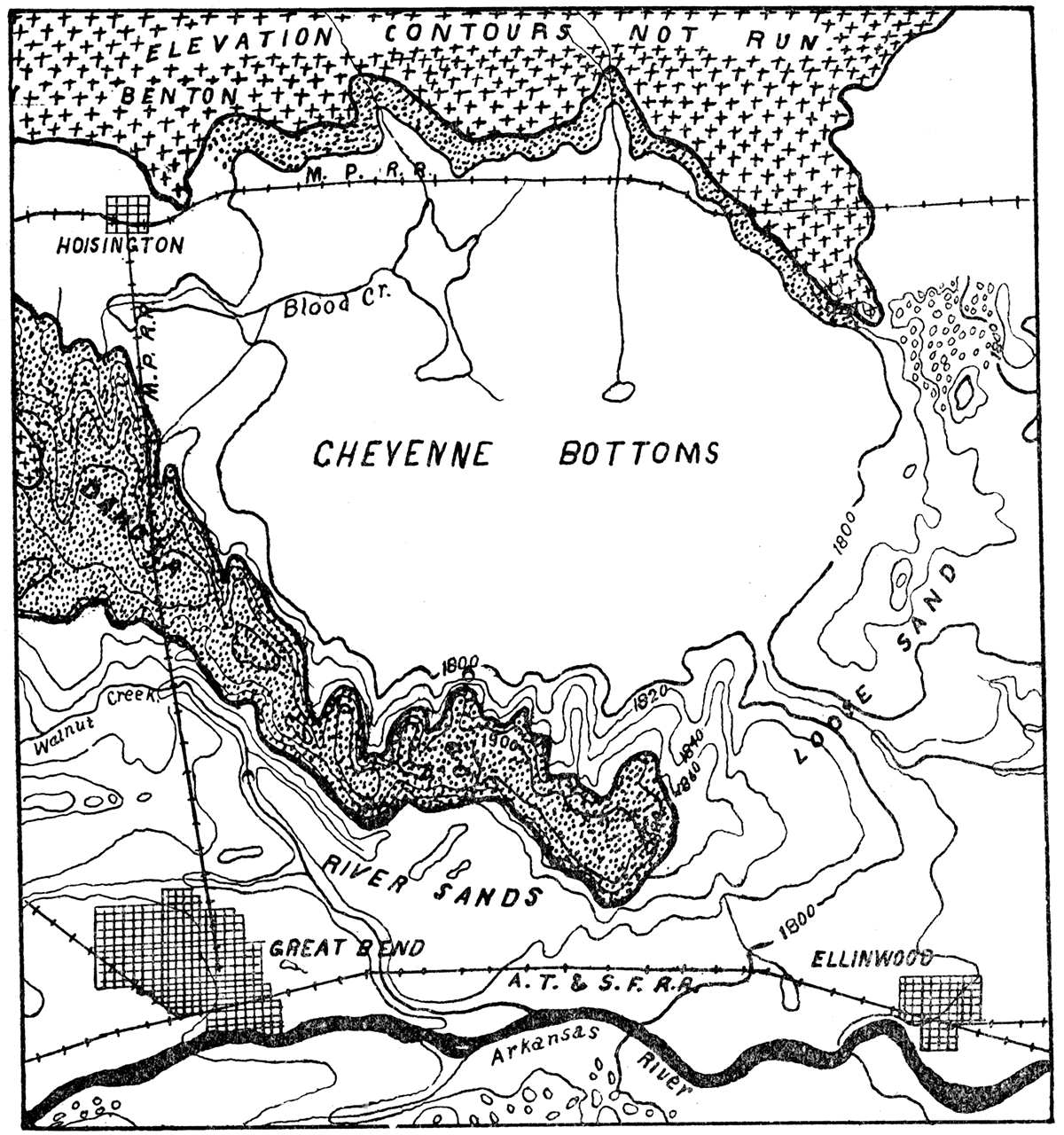
"By reference to the map, figure 1, it will be seen, that on all but the east side the walls are composed of the Dakota formation, with an irregular capping of Benton limestone on the north and west sides. The east wall seems to be entirely sand. Wells sunk on this ridge go through continuous sand until they strike the Dakota. sandstone at some distance below the surface level of the basin. At the northeast corner of the bottoms there are several sandhills similar in form to those on the south side of the Arkansas river."
"In the region of this basin we find the upper part of the Dakota formation, consisting of a layer of sandstone underlain by a thick stratum of soft shales. Owing to the presence of considerable quantities of salt and gypsum in these shales, Mr. W. N. Logan has named them Saliferous Shales. He estimated their thickness at about 30 feet."
"In past time the two streams, Blood creek and Deception creek, which are the only streams of importance entering the basin, probably flowed about as they do now. We suppose at one time their channels were cut into the Benton and the Dakota sandstone. These materials resisting erosion quite well necessarily made the deepening of their channels and the widening of their valleys slow processes. But finally, having cut through these harder strata to the softer stratum of saliferous shales beneath, the processes of erosion were greatly increased, and it was therefore a comparatively short time until the streams had cut their channels entirely through this stratum of shales to the harder layer of sandstone beneath. They now began to widen their valleys, or their valley; for the two streams probably united in one when this shale was first encountered. This widening was likewise rapid, so that a wide valley was soon formed. Had the sandstone overlying this shale bed been very hard we should doubtless have had falls produced of about 30 feet in hight, which would have slowly retreated up stream. There are good reasons for believing that the point where the stream first encountered the shale bed was considerably farther east than the present limits of the basin. Evidence of this is furnished by the fact that river sands cover the surface for some distance in this direction. Thus the valley has been extending np stream as well as widening on either side. The upper courses of the two streams mentioned have not even yet reached the soft, saliferous shales, and consequently have narrow valleys."
"But while this was going on, the Arkansas river was slowly working its way northward by wearing away the soft Dakota sandstones and shales along its northern bank. As the course of the river to this point was northeast and the course of the creek to the southeast, their valleys finally met. A long, wedge-shaped ridge remains, which separates the upper courses of their valleys."
"The breaking down of so much sandstone necessarily left behind great quantities of sand. In the great quantity of sand lying to the south of this wedge-shaped mass of land and in frequent southerly winds, we have the conditions requisite for producing the present basin. The sand blown by the wind across the mouth of this valley formed a drift back of the point of this wedge between the valleys. The drift gradually increased in length and hight until it became a barrier entirely across the valley of the small creek and formed a great basin. The drifting of snow often produces similar results, though on a smaller scale. Could the stream have had considerable water flowing in it continually, it might have been able to keep its channel clear; but probably there was not water enough or current strong enough to carry away the sand that drifted in to the channel."
"Nearly all the wells that have been sunk in this basin produce very strongly mineralized water, much of it so strong that cattle will not drink it. The water is commonly spoken of as salty, but no analysis of the water has yet been made. The mineralized condition of the water is doubtless due to two causes, the evaporation of so much water over the surface and the leaving behind of mineral constituents in the wearing away of the saliferous shales."
The Uplands
The general physiographic features of the uplands of Kansas have already been hinted at while discussing the different streams. Throughout the greater part of the whole western half of the state there is an approach to a level peneplain condition covering the whole of the territory. This is particularly true over the Tertiary areas of the west. The dip of the strata of the Cretaceous limestones and shales and sandstones is east, approximating an angle the same as the inclination of the surface. In a north and south line there is perhaps a general inclination of the strata to the northeast, but the north dip is so slight that it is scarcely perceptible in most places. We therefore have the most favorable conditions for the production of broad level plains by the general weathering of the uplands. In most cases the valleys are simply channels cut into this great peneplain.
There are irregularities in the uplands, however, which are due to the geologic structure and which produce very prominent features in the landscape. Near the eastern limit of the Dakota sandstone we have escarpments facing the east reaching more or less all the way from the north line of the state to the Arkansas river. Such escarpments are produced by the Dakota shales and probably the underlying Permian shales wearing away and the strongly cemented brown Dakota sandstone serving as a protection to the upper surface. In this way a somewhat mountainous appearance is frequently produced, especially where various streams cut their way through the hard sandstone into the softer materials below; Plates V. and VI. represent two such scenes along the Union Pacific railway a few miles west of Brookville, and also Plate XXIV. at Top of Soldier Cap mound. Here the hard Dakota sandstone only a few feet thick has served as a protection to the upper part of the bluffs. The weathering agents have gradually removed the softer sandstone and shales from beneath leaving the harder material above and producing a precipitous escarpment, as shown.
Plate V—Dakota Sandstone bluffs along Union Pacific Railroad, six miles west of Brookville. (Photographed by Haworth, 1895.)
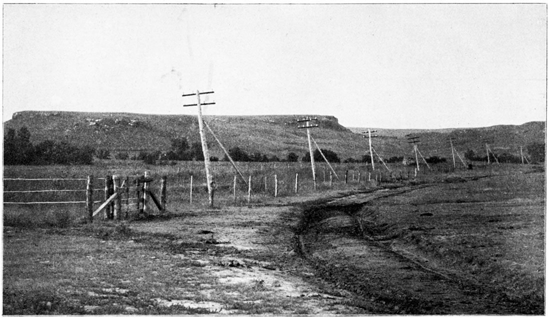
Plate VI—Dakota Sandstone bluffs along Union Pacific Railroad, six miles west of Brookville. (Photographed by Haworth, 1895.)
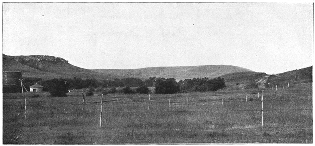
The height of such escarpments is therefore dependent upon the thickness of the softer material which underlies the protecting sandstone. If this should be 100 or 200 feet thick the escarpments usually have a corresponding hight. As the sandstone is traced towards the Arkansas river it is found that the hight of the escarpment gradually declines, until at Pawnee rock it is less than 30 feet, while at the north boundary of the state the hills are from 200 to 250 feet above the surrounding plains.
West of the Dakota sandstone area a prominent row of hills is found trending northeast and southwest, passing over the area covered by the Benton limestone. This range of hills has been called the Blue hills, in allusion to the bluish haze the atmosphere frequently presents when looking at the hills from a distance. These hills are composed principally of the Benton shales, the Blue Hill shales, with a protecting cap of Fort Hays limestone in places. It is a prominent feature of the landscape and can be seen from the east for a distance of from 20 to 40 miles. West of this still is another escarpment likewise trending northeast and southwest, produced by the eastern limits of the Niobrara chalk formations. It passes southwest from Jewell County, reaching almost to the Arkansas river, gradually growing less prominent in the southern direction on account of the thickness of the Niobrara formation correspondingly decreasing. Frequently along these escarpments outstanding mounds or columns are left after erosion has removed all surrounding materials. Plate VII., Castle Rock, is a good illustration of this. It is situated on the north side of the Hackberry, near its mouth in Gove County. Plate VIII. represents such a mound in the process of formation.
Plate VII—Castle Rock, Niobrara Chalk, Trego County. (Photographed by Williston, 1894.)
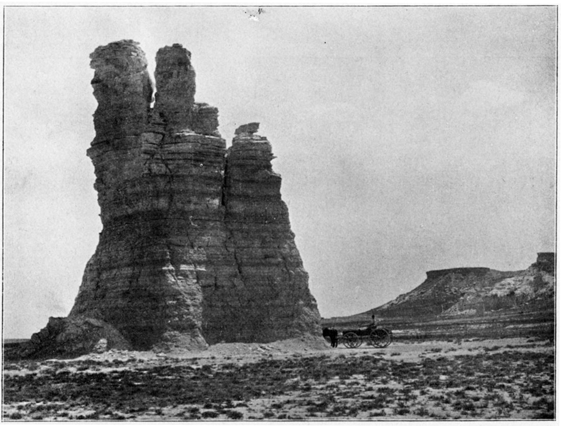
Plate VIII—Lone Butte, Butte Creek, Logan County. (Photographed by Williston.)
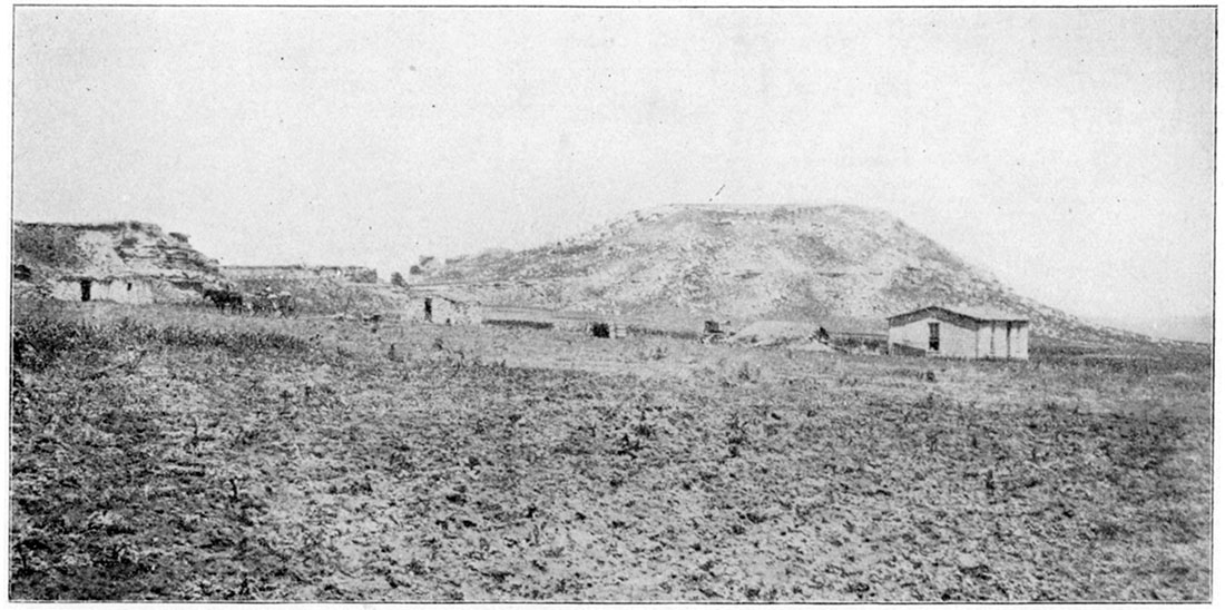
Beyond the Niobrara limits north of the Arkansas river the Tertiary formations are reached. The general character of the uplands throughout the whole of the Tertiary area is that of a broad level plain excepting where it has been cut into by a drainage channel. One of the peculiar features of this part of the state is, that no matter where one may be standing or in what direction one may be looking, it seems as though one is surrounded by higher ground on all sides. This is a feature of the landscape in all prairie countries where the surface is so nearly level. The general eastward inclination of from five to fifteen feet to the mile which obtains throughout the whole of this western country is nowhere noticeable.
South of the Arkansas river the character of the uplands is materially different from that to the north. The broad plains area south of Great Bend is almost level, few streams having cut their channels exceeding 50 to 75 feet deep. One can travel by train across this area on the Santa Fe or the Rock Island, and can hardly notice any variation in the grades until Barber County is reached. From this locality westward the surface is very rugged, due to the great southern inclination. In the vicinity of Medicine Lodge we have a series of conditions similar to that just described for the Dakota sandstone area, excepting that the protecting rock here is gypsum rather than sandstone, the so-called "Mansard beds" south of Medicine river being exceedingly picturesque. See Plates XIII., XIV., XV., XVII., XVIII., XXI., and XXII. Such hills rise to an altitude of more than 500 feet above the valley of the river, and frequently to the altitude of 300 feet above the surrounding valleys. The broad layers of gypsum from 5 to 15 feet thick which occur on the tops of the hills have a regular stratified position and extend for many miles east and west. The general feature of the country is therefore similar to that of the Kearney hills west of Salina, in the Dakota sandstone area. Passing westward still from Barber County the general features of the country in Comanche and Clark counties are similar. The surface of the country drops southeastward in some places at the rate of 30 feet to the mile, producing a large number of drainage channels which have been worn out to an unusual depth resulting in the production of an exceedingly varied topography for the whole surface. See Plate IX. This rugged area covers nearly all the south half of Barber, Comanche, Clark, and Meade counties, beyond which both to the north and west high level plains are again encountered. The general surface of the country south of the Arkansas river and west of Meade County is that of one high upland area smooth as a graded land except here and there a drainage channel has been cut down into the plain like a ditch in a meadow, and presents a monotonous appearance of which the eye soon tires.
Plate IX—Basin sandstone resting on Red-Beds, on Sand Creek, near Cash City, Clark County. (Photographed hy Haworth, 1896.)
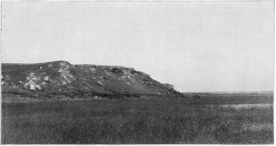
This can not be said of the far west north of the Arkansas river. The geologie formations being so different is the cause for the different results. From the time the Smoky Hill river has entered the state it has cut its channel through the Tertiary and into the Cretaceous formations. Its various tributaries, which are numerous, likewise have done the same, many of which have relatively broad valleys. The result is that a varied and pleasing topography is produced which consists of the flat topped upland areas and the broad valleys from 50 to 200 feet below producing a general scenic condition in many places similar to that of the Kearney hills already referred to. See Plate X.
Plate X—Distant Tertiary hills, Norton. (Photographed hy Haworth, 1896.)
Taken as a whole the western part of Kansas is much more varied in its scenery than one would think from its position in the great plains area. The diversities of elevation are not great, rarely exceeding 300 feet and averaging perhaps less than 200 feet. But when one is near any of the drainage streams one almost invariably finds a varied and pleasing landscape which in many respects is rarely surpassed in America.
Prev Page--Introduction || Next Page--Upper Permian, Lower Cretaceous
Kansas Geological Survey, Geology
Placed on web Jan. 20, 2018; originally published 1897.
Comments to webadmin@kgs.ku.edu
The URL for this page is http://www.kgs.ku.edu/Publications/Bulletins/Vol2/03_phys.html