![]()
Prev Page--Upper Pennsylvanian, Missourian Series || Next Page--References
Upper Pennsylvanian Rocks, continued
Virgilian Series
General Description
The Virgilian rocks of Kansas include Upper Pennsylvanian formations lying between the unconformity that defines the upper limit of Missourian rocks and the similar unconformity, which is marked mainly by locally prominent channel sandstone (Indian Cave), at the Pennsylvanian-Permian boundary. In outcrops along the Kansas River Valley east of Lawrence, and in the vicinity of Leavenworth, the lowermost Virgilian sandstone (locally conglomerate), which is included in the Stranger formation, lies directly on eroded members of the Stanton limestone, from uppermost to lowermost; no rocks of Pedee age (latest Missourian) are present. Northward and southward from Kansas River, varying thicknesses of Pedee strata are found to have been left by the pre-Virgilian erosion, but locally, as southwest of Chanute, the unconformity cuts downward deeply into rocks of the Lansing group.
The formations belonging to the Virgilian Series in Kansas are characterized on the whole by regularity of arrangement and persistence of stratigraphic units, including members and subdivisions of members. Limestones alternate with shale in vertical succession, and marine deposits alternate with nonmarine. The general uniformity of sequence and approximately constant thickness of Virgilian rock divisions across Kansas are best developed in the middle and upper parts of the succession (Shawnee and Wabaunsee groups). They are not exhibited by lower Virgilian strata belonging to the Douglas group, even though some units are widely extended. No part of the Pennsylvanian section in the northern midcontinent region contains clearer evidence of cyclic sedimentation than that seen in characters of Shawnee and Wabaunsee cyclothems, especially. The Shawnee group contains the most complete--or at least the most complex--examples of cyclically arranged cyclothems which have been termed megacyclothems (Moore, 1936, p. 29), whereas numerous Wabaunsee formations exhibit unusually well-differentiated, widely persistent phases of individual cyclothems, which are not grouped in the pattern of Shawnee megacyclothems.
The Virgilian limestones include several different kinds of calcareous rock. These occur in such relation to other strata and to one another and they are associated so constantly with certain paleontological characters that their differences must be interpreted inescapably as lithologic records of several combinations of environmental elements. The chief types of limestones are (1) light-gray, very fine-grained, thin-bedded rock having wavy partings of thin shale; (2) dark-bluish, dense, brittle, massive limestone, which weathers blue-gray; (3) bluish-gray, irregularly thick-bedded, ferruginous limestone, which weathers to rich-hued shades of brown; and (4) light-gray to nearly white, massive rock of nodular structure, which is seemingly of algal origin. These types represent phases of cyclothems. The limestones are expressed topographically by escarpments and benches on the fronts of escarpments and along valley walls. Also, the thicker limestone units underlie dip-slope plains of varying width, where covering weak strata have been stripped away. The Virgilian limestones influence the nature of residual soils and their outcrop areas are marked by types of vegetation adapted to these soils.
Shaly formations of the Virgilian section in Kansas are also of several types, which are differentiated by composition, color, bedding, organic content, mode of weathering, and average thickness. As shown by their fossil content and other features, some are nonmarine and others, which constitute a majority, are marine. The most important types are: (1) light-colored (gray, bluish, greenish, yellowish) clayey and sandy shales, which are noncalcareous, poorly to only moderately well laminated, and generally unfossiliferous; (2) red clayey to silty, poorly bedded, unfossiliferous shales; (3) bluish-gray to light brownish, calcareous shales, which are mostly well laminated and contain numerous marine fossils; and (4) black, highly carbonaceous, fissile, platy shales which commonly bear conodonts and some corneous brachiopods. Many of the Virgilian shale units are thick--that is, 50 to 100 feet from lower to upper limits--but these divisions are less regular than many shale units, especially the black platy shales, which have a maximum thickness of only 5 or 6 feet.
Sandstone is a prominent constituent of Virgilian deposits belonging to the Douglas group, and it is important in many of the thicker shale bodies of the Shawnee and Wabaunsee groups. Viewed from the standpoint of regional distribution, attention is drawn at once to the smaller sand content of the Virgilian deposits in northern Kansas and Nebraska and much larger proportion of sandstone throughout the section in southern Kansas and Oklahoma. Traveling northward along the strike of Upper Pennsylvanian formations, one moves basinward, whereas traveling southward he approaches territory which was the site of dominant subaerial sedimentation. Thick nonmarine sandstones and abundant redbeds characterize the latter region, which, however, does not include Virgilian deposits of Kansas; the described type of section is seen from northern Oklahoma southward. Some Virgilian sandstones are channel fills, as is demonstrated by their convexity of base and relations to underlying strata. A majority of the sandstones are widespread sheets.
Coal beds are observed in each of the Virgilian groups and are distributed from near the base to within a few feet of the top of the section representing this stage in Kansas. With minor exception, however, the Virgilian coal beds are too thin for commercial exploitation. Their most interesting features are constancy of occurrence in relation to cyclothems and surprising horizontal extent. Some coal beds of the Wabaunsee group are found at virtually every exposure of the part of the section in which they occur so that they can be traced as continuous layers from northern Oklahoma to Nebraska and Iowa; yet maximum thickness of the coal beds is commonly only a few inches.
The outcrops of formations belonging to the Virgilian Series occupy a south-southwestward-trending belt across Kansas from the boundary along the northeast, which is made by the Missouri River, to the south boundary of the State in Chautauqua County (Fig. 1). The outcrop belt is widest in the north and narrowest in the south. Holton, Lawrence, Topeka, Emporia, Yates Center, Eureka, and Sedan are cities located within the area of exposed Virgilian formations. An outlying outcrop strip, which belongs to upper rocks of the series, extends northward from the Kansas River Valley near Manhattan; it is located along the axis of the Nemaha granite ridge anticline, where erosion has removed the cover of Lower Permian rocks.
Rocks of the Virgilian Series are divided into three groups, in upward order: Douglas, Shawnee, and Wabaunsee (Fig. 2).
Douglas Group
Definition
The Douglas group (Haworth, 1898, p. 93), named from Douglas County, Kansas, comprises the lowermost part of the Virgilian Series, extending upward from the disconformity at the lower boundary to the base of the Oread limestone.
As originally defined, the term Douglas was used to embrace the predominantly shale and sandstone deposits occurring between the top of the Stanton formation and top of the Oread formation. The Oread is one of the best-marked escarpment makers in the Pennsylvanian succession of the northern midcontinent and naturally it was chosen as marking an important stratigraphic boundary. The line mapped by Haworth and his associates to show distribution of the Oread follows the escarpment front and coincides with the base of the lowermost limestone. Inasmuch as the Oread commonly makes a broad dip slope, the contact between the upper limestone and overlying shale (Kanwaka) is a topographically inconspicuous line which in most places is some miles west of the escarpment front. Partly on cartographic grounds but more on the basis of lithologic characters and megacyclothem relationships which call for associating the Oread beds with Lecompton, Deer Creek, and Topeka beds, Moore (1932) redefined the stratigraphic span of the Douglas group to exclude both upper Missourian deposits (Weston, Iatan) and the Oread formation.
As previously defined by the Kansas Geological Survey and now recognized by the interstate conference, the Douglas group comprises the strata, almost exclusively clastic, occurring between the disconformity at the base of Virgilian rocks and the base of the Oread formation (Figs. 2, 22, 24, 25). Lateral variations in the nature of the Douglas deposits naturally impose differences in local classification and it is not intended to exclude such differences as may be judged needful in the several states.
Where the disconformity that marks the boundary between Missourian and Virgilian beds is not identifiable in wells, the clastic deposits between the Stanton and Oread limestones may be termed Pedee-Douglas.
Figure 22. Classification of lower Virgilian rocks in the northern midcontinent area adopted by interstate conference of geological surveys. The agreed classification is compared with those previously used in the several states.
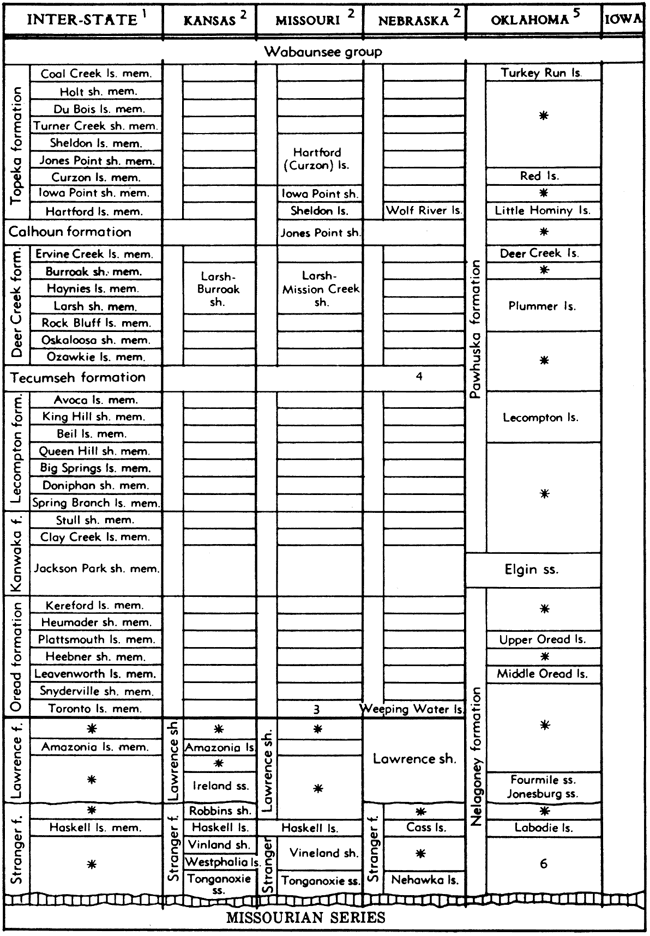
1. In the interstate column, not all subdivisions, particularly in Douglas group, are recognized in Missouri, Nebraska, Oklahoma, and Iowa.
2. Classification same as interstate excepting as shown.
3. Called Toronto or Weeping Water limestone by McQueen and Greene (1938).
4. Tecumseh shale in Nebraska is divided into members, in upward order, Kenosha shale, Ost limestone, Rakes Creek shale.
5. Classification not yet adequately investigated or reported in publications of State Geological Survey. Many Shawnee units have been identified, but correlation of some with stratigraphic units in Kansas and other states is not definitely known.
6. Shale and sandstone, including Chesewalla sandstone, and possibly Revard and Bigheart sandstone.
* Subdivision unnamed.
Distribution and Thickness
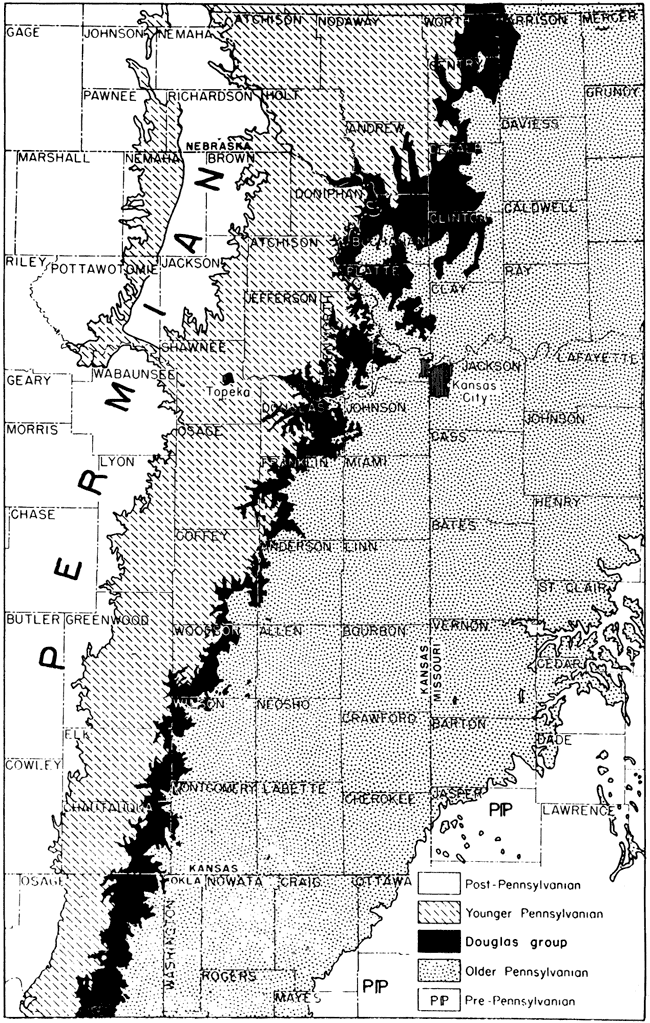
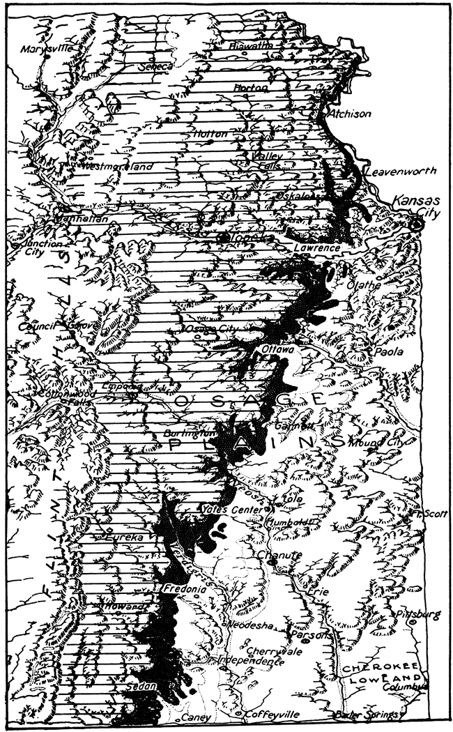
The outcrop belt of Douglas rocks is generally a rolling plain, bounded on the west by the east-facing Oread limestone escarpment and on the east by the contact of basal Douglas sandstone on weak Pedee strata or upper Stanton limestones which form a dip slope. This eastern boundary is very poorly expressed by topographic features. The width of the exposed Douglas strata is only 3 or 4 miles on the average, but locally it is as much as 30 miles (Fig. 23). The outcrop belt is mapped across Kansas from northeastern Doniphan County to eastern Chautauqua County. The trend of the belt is comparatively straight in a south-southwest direction. Best outcrops of Douglas beds are seen in Leavenworth and Douglas counties adjacent to the Kansas River Valley, and farther south in Franklin, Coffey, Woodson, Wilson, Elk, and Chautauqua counties. In southern Kansas, the Douglas outcrop area is an upland formed by hard sandstone layers and it is not topographically differentiated sharply from belts belonging to older and younger rocks. This area is continuous with rough scrub-oak country of eastern Osage County, Oklahoma, which is underlain by stratigraphic equivalents (lower Nelagoney formation) of the Douglas group.
The thickness of the group ranges from about 50 feet in southeastern Nebraska to nearly 700 feet in southern Kansas. In northeastern Kansas and northwestern Missouri the Douglas beds are 150 to 250 feet thick.
Figure 23. Distribution of outcrops, of the Douglas group in Kansas and parts, of adjoining states. This group is not recognized in classification of rocks of Oklahoma; outcrops south of Kansas shown as equivalent to Douglas deposits are included in the Nelagoney formation.
Lithologic Character and Classification
The Douglas group consists primarily of clastic deposits, in which fairly thick bodies of massive or cross-bedded sandstone, shaly sandstone, and sandy shale are prominent. It contains two persistent, though rather thin, limestone beds (Haskell, Westphalia) in the middle or lower part, and some coal beds. Locally, conglomerate occurs at the base of the group.
As now classified, the rocks of the Douglas group are divided in two formations, called Stranger and Lawrence, respectively. These formations are separated in many places by a disconformity (Figs. 24, 25).
Stranger Formation
The Stranger formation (Newell, in Moore, 1932y p. 93) is defined (Moore, 1936, p. 147) to embrace nonmarine and marine beds of the lower part of the Douglas group extending upward from the base of the Virgilian rocks to a disconformity at the base of the Lawrence formation (Figs. 22, 24, 25). The type section of the formation is in southern Leavenworth County, Kansas. In northern Kansas, the upper boundary of the Stranger formation is at or near the Haskell limestone, but in southern Kansas a considerable body of marine shale belonging to the Stranger formation occurs above the Haskell limestone.The thickness of the Stranger formation ranges from about 30 feet in northernmost exposures to about 300 feet in southern Kansas.
Tonganoxie sandstone member. The Tonganoxie (Moore, Elias, & Newell, 1934) sandstone member includes cross-bedded channel sandstones, sandy shales, and several thin coal beds, comprising all strata from the base of the Stranger formation to the top of the upper Sibley coal or base of the Westphalia limestone (Figs. 24, 25, 26). Nearly all the sediments of the Tonganoxie in Kansas are nonmarine. Seemingly, they are fluviatile deposits laid down on a broad coastal plain.
In much of Douglas, Leavenworth, and Wyandotte counties, massive sandstones at the base of the member rest unconformably on various parts of the Stanton, Weston, and Iatan formations. Conglomerate composed of cemented pebbles of limestone occurs at the base of the member. The sand of the thick Tonganoxie beds is composed chiefly of angular quartz grains, having an average diameter of 0.2 mm. Somewhat larger grains of muscovite are common and characteristic. The sandstones are characteristically cross-bedded, and in northeastern Kansas the foreset beds dip generally in a westerly direction. Probably much of the Tonganoxie sand in southern Kansas was derived from a southern source. The sandy shales interbedded with the sandstone beds locally contain plant fragments, but do not have marine fossils. Coal beds occur in the north but disappear southward. One of these beds is about 30 feet and another 55 feet below the top of the member.
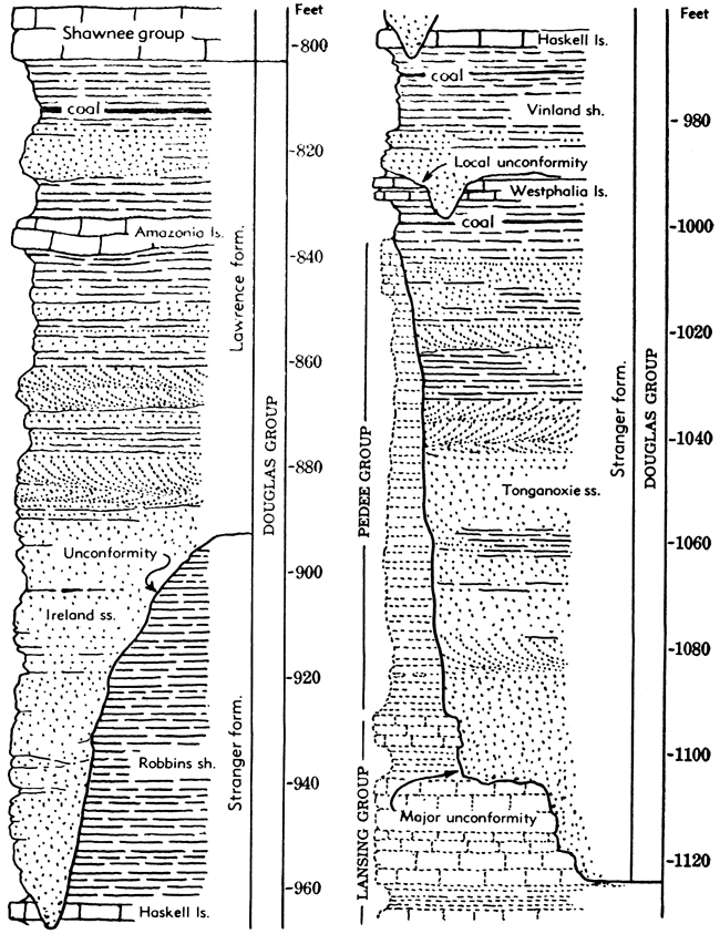
Figure 24. Generalized columnar section of rocks belonging to the Douglas group in Kansas. These rocks comprise the lowermost part of the Virgilian Series in this region.
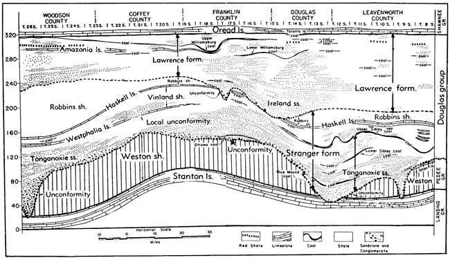
The Tonganoxie sandstone consists mostly of discontinuous lenses and channel-fillings (Fig. 25). The lower contacts are obviously unconformable on underlying strata, as evidenced by overlap relations, irregular sharp contact, and local masses of conglomerate at the base. At least five separate channel deposits are recognized at outcrops in Kansas. Toward the margins the channel fillings wedge out into homogeneous shale, as near Baldwin, west of Garnett, near Yates Center, and near Elk City.
The Tonganoxie member is exceedingly variable in thickness, ranging from 3 feet near Elk City, Kansas, to nearly 100 feet in eastern Leavenworth County.
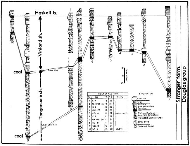
Figure 25. Stratigraphic diagram of Douglas and adjoining rocks in part of eastern Kansas. The diagram shows subdivisions of the Douglas group and varying stratigraphic relations as seen along the outcrop from the vicinity of Leavenworth to Yates Center, in Woodson County (Redrawn from Bowsher & Jewett.) A larger version of this figure is available.
Westphalia limestone member. Throughout most of its outcrop area the Westphalia limestone (Moore & Newell, in Moore, 1936, p. 150) is characterized by abundant fusulinids (Triticites secalicus oryziformis). The member is not definitely recognized at the outcrop north of T. 19 S. (Fig. 25). At its northernmost unquestioned outcrops in northwestern Anderson County, the member is overlapped by a channel filling (Ireland sandstone) belonging to the Lawrence formation. The Westphalia and its equivalents are cut out by the Ireland throughout southern Franklin County. The Westphalia limestone may be represented by a thin limestone above the Sibley coal near Baldwin, Kansas, and Iatan, Missouri. This limestone, 0.2 to 1 foot thick, is finely laminated and commonly contains thin layers of reworked coaly material; well-preserved plant fossils are found on the bedding planes. It also contains the marine ostracode Jonesina howardensis and minute gastropods. The interval between this limestone and the Haskell limestone corresponds to that of the Westphalia and Haskell.
The Westphalia limestone was well known in the subsurface before it was recognized at the outcrop. Together with the Haskell, it can be recognized as far west as R. 6 W. (Kellett, 1932), where both beds are overlapped by younger rocks on the flanks of the Central Kansas uplift.
Vinland shale member. The next higher member of the Stranger formation includes shale and sandstone, probably all marine, between the Westphalia and Haskell limestones (Figs. 24, 25, 26). It is called the Vinland shale (Patterson & Addison, in Moore, 1936, p. 151). The member consists of 9 to 50 feet of gray argillaceous, calcareous or sandy shale, and locally some sandstone. In Woodson County, a dark-green layer near the middle of the member may be equivalent to a persistent variegated layer known at this horizon in the subsurface (Kellett, 1932) of central Kansas.
The Vinland shale is ordinarily highly fossiliferous at many places along the outcrop. A well-preserved molluscan fauna in the shale near Iatan and Weston includes the clam Nuculana arata, described from this area more than 80 years ago. Near Lawrence the member is sandy and rather unfossiliferous, but from Vinland southward into Oklahoma a zone of prolific Myalina occurs near the top.
Haskell limestone member. A remarkably persistent and uniform limestone, which occurs next above the Vinland member, is called the Haskell limestone (Moore, 1932) (Figs. 24, 25, 26). Undoubtedly it is the best key bed between the Lansing and Shawnee groups. Throughout much of the outcrop the Haskell is a bluish-gray, blocky, fine-grained limestone, occurring as a single ledge without shale partings. The Haskell contains the alga Ottonosia ("Cryptozoon") and some fusulinids and brachiopods. Locally, oölitic layers occur at the base and top of the member. The upper oölite layer at Lawrence furnished the types for several pelecypods described by Beede & Rogers (1900). Northeastward, in Missouri, the member becomes shaly. The shale just below the Haskell limestone in Chautauqua County contains a prolific molluscan fauna, which resembles that associated with the Labadie ("Wildhorse") limestone of Osage County, Oklahoma. Probably the two limestones are the same.
Commonly, the Haskell is only 2 to 4 feet thick.
Robbins shale member. Above the Haskell limestone lies a marine, argillaceous shale of a variable thickness, which is called Robbins shale (Moore & Newell in Moore, 1936, p. 153) and classed as topmost member of the Stranger formation (Figs. 24, 25, 26). It is overlain unconformably by the Ireland sandstone. The shale above the Haskell and below the Oread limestone for a long time was classed as a single formation, the Lawrence shale. Inasmuch as the hiatus at the base of the Ireland sandstone seems to extend across Kansas, it calls for recognition in stratigraphic classification, and is now recognized as the boundary between the Stranger and Lawrence formations. In northeastern Kansas, the Ireland sandstone rests on the Haskell limestone or beds just above the Haskell. Southward, the base of the Ireland sandstone rises, so that in southern Kansas a thick wedge of clayey shale separates it from the Haskell. In this area, the base of the Lawrence, as defined by the Ireland, occurs scores of feet above the Haskell.
Figure 26. Sections of upper Stranger beds in Leavenworth and Douglas counties, Kansas. (Modified from Bowsher & Jewett).
South of Lawrence, the Robbins shale is first definitely recognized near Baldwin, where it is 1 to 5 feet thick. At several outcrops in this area the Robbins and Haskell are cut out and overlapped by the Ireland. A persistent zone of ellipsoidal phosphatic concretions occurs at the base of the Robbins shale from Baldwin to Leavenworth. These concretions contain brain casts of fish, and ammonoid cephalopods. Southward from Yates Center, in Woodson County, the Robbins shale, consisting chiefly of gray argillaceous and silty shale, thickens to about 100 feet. Some massive sandstone beds appear abruptly in the Robbins in Chautauqua County and probably continue into Oklahoma.
Lawrence Formation
The Lawrence formation was originally defined (Haworth, 1894a, p. 122) to include strata belonging between the limestone now called Haskell and the base of the lower limestone of the Oread formation. Later the definition was amended by Moore & Newell (in Moore, 1936, p. 154) to exclude beds assigned to the Robbins shale member of the Stranger formation. The Lawrence formation is thus defined to embrace rocks between the base of the Ireland sandstone, or equivalent horizon, and the base of the Oread formation (Figs. 22, 24, 25). The Ireland is unrecognizable in the vicinity of Lawrence and in this area the lower limit of the Lawrence is placed at the top of the fossiliferous, phosphatic concretions known to occur in the Robbins elsewhere.
The upper limit of the Ireland sandstone is indefinite and probably does not constitute a single stratigraphic horizon (Fig. 25). Although the lower part of the Ireland is almost invariably massive cross-bedded sandstone, devoid of marine fossils, the higher part grades upward into sandy shale. Where the Ireland is well developed, it makes up the lower half to two-thirds of the formation, not uncommonly attaining a thickness of 100 feet. Where the Ireland rests on Tonganoxie sandstone, as in the Leavenworth area, the lower boundary of the Lawrence formation cannot be recognized exactly. Identification of the presence of Ireland in this area rests on observation that the upper part of the sandstone mass rises 30 or 40 feet above position of the Haskell limestone, which is missing in the sandstone area, although clearly recognizable at Weston and Iatan, Missouri, not far distant.
A prominent Ireland channel-filling in southwestern Douglas and western Franklin counties marks the base of the Lawrence formation in that area, where Rich (1933, p. 865) has described angular coal fragments in the basal part of the Ireland. The coal fragments, derived from the Sibley coal bed, were altered to hard coal before the pre-Lawrence erosion. According to Rich, the long time which probably was involved in making the coal suggests an important break at the base of the Ireland. The evolutionary change in invertebrates between the Stanton and Oread formations certainly is not pronounced, however, for scarcely any faunal break is seen in this part of the column. Seemingly, the time involved in the pre-Virgilian disconformity, plus that represented by the pre-Lawrence hiatus, is not measurable in terms of evolution of Pennsylvanian faunas.
At least two fairly persistent coal beds occur in the upper part of the Lawrence in northeastern Kansas. The more important bed is the Upper Williamsburg coal, which occurs 15 to 40 feet below the Oread limestone (Bowsher & Jewett, 1943). This coal extends from the vicinity of St. Joseph, Missouri, to northeastern Greenwood County, Kansas. It is more than 1 foot thick near Williamsburg, in Franklin County, where it is mined. The other coal, which occurs 5 to 30 feet below the Williamsburg bed, extends from St. Joseph to Baldwin, in southern Douglas County, Kansas, and occurs sporadically as far south as Woodson County (Fig. 25).
A massive nodular limestone, ranging up to 15 feet thick, occurs some 25 to 60 feet below the top of the Lawrence formation in northwestern Missouri. North of Iatan, Missouri, this limestone (Amazonia) occurs about 65 feet below the Oread and 70 feet above the Haskell (Fig. 24). In central and southern Kansas it appears to lie between the Lower and Upper Williamsburg coal beds (Bowsher & Jewett, 1943, p. 98) (Fig. 25).
A clayey and calcareous maroon shale is widely distributed between the Williamsburg coal beds and just above the Amazonia limestone (Fig. 25). This shale commonly occurs as one irregular bed, 1 to 5 feet thick, but in places there are three or more layers of maroon shale separated by greenish or buff shale. The zone extends from St. Joseph to southern Douglas County, Kansas, but is unrecognized farther south until it reappears in Woodson County. Maroon shales are common in and above the Ireland sandstone in Chautauqua County, Kansas, and northern Osage County, Oklahoma.
The only named members of the Lawrence formation are the Ireland sandstone and Amazonia limestone.
Ireland sandstone member. Massive or irregularly cross-bedded buff to brownish sandstone, some tens of feet thick, is prominent in the lower part of the formation at many places. This sandstone is designated as the Ireland member (Moore, 1932, p. 93) (Figs. 24, 25). Its main characters and stratigraphic relations have been described. In the type region of the Ireland sandstone in Woodson County, Kansas, the top of the member is only a few feet below the top of the Lawrence. North of Kansas River and in subsurface sections extending to west-central Kansas, sandstone bodies in the middle and lower part of the formation have been classed as Ireland.
The thickness of the Ireland sandstone ranges from a featheredge to about 125 feet.
Amazonia limestone member. A prominent limestone which occurs about 24 feet below the top of the Lawrence shale at Amazonia, Missouri, and near Wathena, Kansas, is defined as the Amazonia limestone member (Hinds & Greene, 1915, p. 31) (Fig. 24). Southward the shale above the Amazonia gradually thickens to more than 60 feet southeast of Atchison. Hinds & Greene report as much as 100 feet of Lawrence beds above the Amazonia, between Rushville and St. Joseph, Missouri. At the type locality in Andrew County, Missouri, the Amazonia member is 9 feet thick. Near St. Joseph and Wathena it is 13 to 15 feet thick but southward it gradually diminishes and disappears. It is believed to be represented by a rather thin mottled nearly unfossiliferous limestone in central and southern Kansas (Bowsher & Jewett, 1943).
The physical characters of the Amazonia limestone in northeastern Kansas and northwestern Missouri are very similar to those of the Iatan limestone. It is a light-gray rock when fresh and weathers nearly white with irregular brownish mottling. Most of the beds are very fine-grained and dense but in places the upper part is coquinoid or appears fragmental, containing rounded or angular pieces of dense gray rock in a brownish matrix. Bedding is poorly developed and the member tends to weather, therefore, as a very massive ledge, which breaks along joint planes allowing large blocks to slump downward on steep slopes. Weathering of the faces of these blocks or of the bed reveals a faint but distinct uneven, wavy stratification. Fossils are not abundant generally, but in some outcrops and in certain parts of the member numerous brachiopods, bryozoans, crinoid fragments, and some other invertebrate remains may be found. Sponges are abundant in exposures of the Amazonia southeast of Atchison.
Shawnee Group
Definition
As originally defined and subsequently used in Kansas and adjacent states for many years, the Shawnee group or "formation" (Haworth, 1898, p. 93) includes the beds from the base of the Kanwaka shale to the top of the Scranton shale (base of Burlingame limestone). There is no evident reason for this segregation of strata except inclusion together of beds between two readily mappable escarpments. Consistency, even on this basis, would require the inclusion of the Oread limestone in the Shawnee group, because the line that is followed in mapping an escarpment is the base, rather than the top, of the resistant bed, which may have a dip slope of several miles.
The Shawnee group as redefined by Moore (1936, p. 159) includes beds from the base of the Oread limestone to the top of the Topeka limestone. Thus limited, the group is a very well differentiated assemblage of strata, in which thick limestones and a distinctive type of cyclic sedimentation are prominent features. This stratigraphic span has been recognized uniformly in reports of the Kansas and Nebraska geological surveys and in many other papers during the last 15 years but until recently it has not been accepted by the Missouri and Iowa geological surveys. The interstate conference recognizes classification of the Shawnee group as shown in Figure 22. The persistence of most stratigraphic units and the surprising uniformity displayed throughout their known area of distribution in Iowa, Missouri, Kansas, and Nebraska permit unusual uniformity in classification and nomenclature. Problems are introduced, however, near the Kansas-Oklahoma boundary owing to southward change of facies.
Distribution and Thickness
The Shawnee outcrop belt occupies the middle part of the area underlain at the surface by Virgilian formations. The Shawnee rocks are mapped across Kansas from Doniphan County, on the north, to Chautauqua County, on the south (Fig. 27). The width of the outcrop belt averages about 20 miles. Excellent exposures of Shawnee limestones, and less commonly, shale deposits, are found in virtually every county crossed by the belt. It is distinguished from the Douglas and Wabaunsee belts by the greater prominence of escarpments and generally more rugged topography, except as compared with outcrops of Douglas strata in southern Kansas (Fig. 28). In the vicinity of the Kansas River Valley, each of the Shawnee limestone formations makes a well-defined escarpment, but in southern Kansas, diminution of the shale between the upper two limestones (Deer Creek, Topeka) brings these together in a single escarpment. North of Kansas River, the cover of glacial drift partly masks bedrock topography and in this part of the State the Shawnee escarpments are indistinct. Best exposures are found in many quarries and in the bluffs of stream valleys.
Figure 27. Distribution of outcrops of the Shawnee group in Kansas and parts of adjoining States. South of the Kansas-Oklahoma boundary, rocks equivalent to the Shawnee group are classed as belonging to the upper part of the Nelagoney formation, Elgin sandstone, and Pawhuska formation.
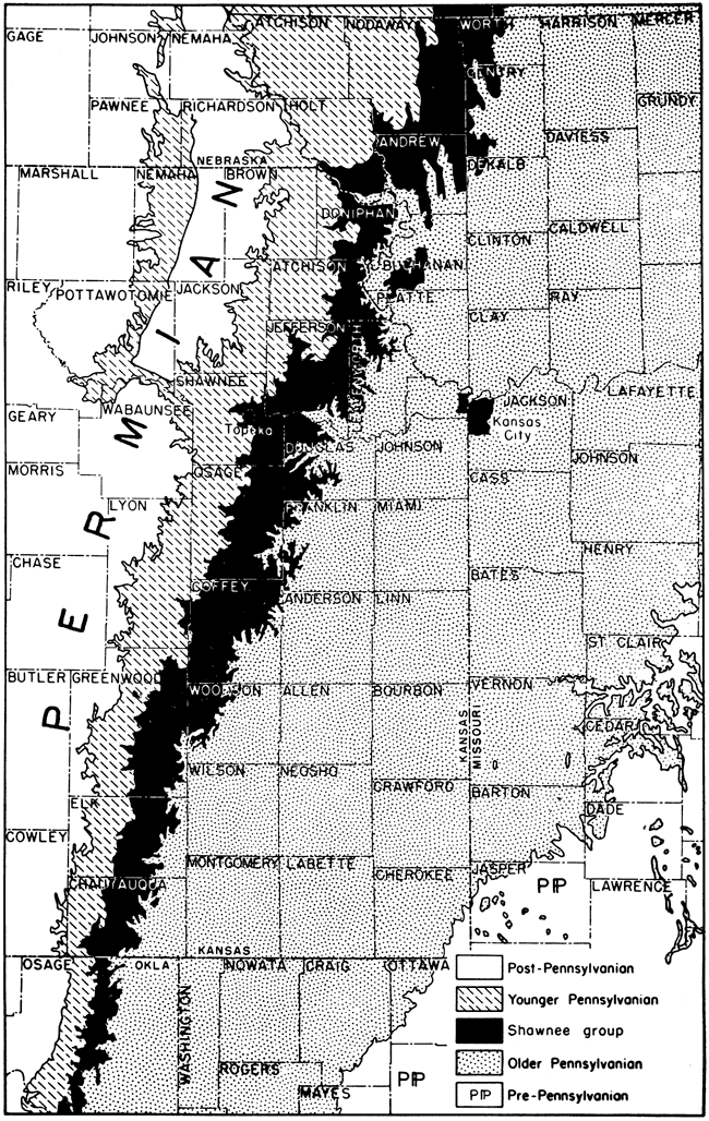
Figure 28. Escarpments formed by Pennsylvanian and Lower Permian limestones in eastern Kansas. The outcrop belt of Virgilian rocks is shaded, the dark band along the eastern margin representing Douglas strata and higher groups ruled horizontally. The prominent limestones of the Shawnee group form escarpments just west of the Douglas belt.
The Shawnee group underlies all of Kansas west of its belt of outcrop excepting small areas along the northern part of the Nemaha ridge where Wabaunsee strata lie directly on Pre-Cambrian rocks. In tracing these beds underground, it is found that the limestones converge to form a thick body of nearly solid limestone, which is readily separated from the clastic Douglas beds below and from the shaly strata and thin limestones of the Wabaunsee group above. Paleontologic characters of the Shawnee beds are in harmony with the present grouping.
Beyond the borders of Kansas, outcrops of Shawnee rocks are traced across northwestern Missouri into southwestern Iowa. All formations belonging to the group are exposed also in southeastern Nebraska. Although rocks of Shawnee age in Oklahoma are differently named than in Kansas, outcrops are traced readily across the central part of Osage County southward. Equivalents of the Shawnee group in northern Oklahoma include the topmost beds of the Nelagoney formation (Oread), Elgin sandstone, Pawhuska formation, and approximately the lower 50 feet of the Buck Creek formation.
Thickness of the Shawnee group along the outcrop belt in Kansas is fairly uniform, amounting to about 350 feet. This lack of variation in total thickness is somewhat surprising in view of considerable change in thickness of individual Shawnee formations. Evidently, thickening of some formations along parts of the outcrop belt is compensated by thinning of others.
Lithologic Character and Classification
The Shawnee group is especially distinguished by prominence of limestones (Fig. 29). In this respect, the Shawnee part of the Virgilian Series is comparable with the Kansas City and Lansing groups of the Missourian Series. The mid-portion of Virgilian time was characterized in the Kansas region by maximum accumulation of clear-water calcareous sediments which seem to be mainly organic in origin. Clastic deposits are not lacking, for in total thickness they exceed the aggregate of all limestone beds, but they are much less prominent than the limestones.
Figure 29. Generalized columnar section of rocks belonging to the Shawnee group in Kansas. These rocks comprise the middle part of the Virgilian Series in the northern midcontinent region.
Four formations assigned to the Shawnee group are largely, if not predominantly, made up of limestone. The three intervening formations consist mainly of shale and sandstone. These alternating calcareous and clastic deposits reflect major cyclic oscillations of sedimentation, which furnish evidence of important back and forth shifting of the strand lines of Virgilian seas. Sedimentation associated with retreat of the shallow seas consists of coal beds and nonmarine sandstone and shale, some of which contain well-preserved land plants. Marine sedimentation is represented by the limestones and by several types of shaly deposits; most of these strata contain marine invertebrates of various sorts. The arrangement of terrestrial and marine deposits indicates both a simple progression in cyclic sedimentation, in which as many as a dozen distinct environments are represented, and a repetition of sets of cycles in constant order. The compound cyclic arrangement of Shawnee deposits is expressed in units named megacyclothems (Moore, 1936, p. 29). Each Shawnee megacyclothem includes four or five simple cyclothems having individual peculiarities (Figs. 30, 31). The various kinds of limestone and shale are described in discussing formations of the Shawnee group. The presence of cyclothems (designated by the letter "A" in Figures 30 and 31) characterized by prominent brown-weathering massive limestone, which contains abundant fusulinids in many places, distinguishes the Shawnee megacyclothems from those recognized in Missourian and Desmoinesian deposits of Kansas and Missouri.
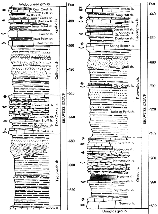
The Shawnee group contains the following formations, named in upward order: Oread limestone, Kanwaka shale, Lecompton limestone, Tecumseh shale, Deer Creek limestone, Calhoun shale, and Topeka limestone.
Figure 30. Sections of upper Lansing and lower Shawnee beds showing cyclothems and megacyclothems. The cyclothems are indicated by the letters A-E. Megacyclothems include the entire sequence of beds in any one of the three plotted sections, R, S, T. Stratigraphic position of the sequences is indicated on the general section at right in Figure 31.
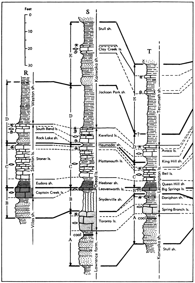
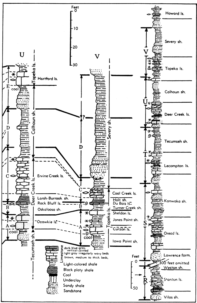
Figure 31. Sections of upper Shawnee beds showing cyclothems and megacyclothems. These units are differentiated as explained in description of Figure 30.
Oread Limestone
The Oread formation (Haworth, 1894a, p. 123; 1895, p. 461) is a prominent scarp-forming limestone named from the hill on which the University of Kansas at Lawrence is situated. Haworth first applied this name only to the lowermost limestone of the formation, but later extended it to include the overlying thick light-gray limestone now commonly known as the upper Oread or Plattsmouth limestone. An intermediate thin blue limestone (Leavenworth member) was not differentiated in early reports. As later recognized (Moore, 1936, p. 161), the Oread includes not only these three limestones and the intervening shales, but a still higher limestone that is oölitic or composed of dense dark-blue flagstone (Figs. 22, 29, 30). This upper bed, called "Waverly flagging" in older literature, comprises a distinct element in the Oread megacyclothem, and was included with the Oread beds by Bennett (1896) and Hinds & Greene (1915). It was named the Kereford limestone by Condra (1927).
The total thickness of the Oread formation in the type area at Lawrence is 45 feet. The Lawrence shale lies conformably beneath the Oread and the Kanwaka shale is conformable above.
Because of the resistance to erosion afforded by the Oread limestone its outcrop is marked by a prominent escarpment that may be traced entirely across Kansas from Doniphan County in the northeast to Chautauqua County on the Oklahoma border. In the northern half of the State shale members of the Oread are thin, and the limestone members accordingly are close together, forming subordinate benches of a single escarpment. In southern Kansas, however, the lower shale member increases in thickness to 75 feet or more, so that separate escarpments which are locally a mile or more apart are made by the Toronto (lower Oread) limestone and the Leavenworth-Plattsmouth (middle and upper Oread) members. Coincident with the increase in thickness of the lower shale (Snyderville) member is prominence of red shale and appearance of nodular limestone and calcareous sandstone beds in this part of the formation. Disappearance of the limestone members of the Oread in northern Oklahoma makes it impracticable to differentiate the formation as a stratigraphic unit in this region. The equivalent strata are included in the upper part of the Nelagoney formation.
The Oread limestone contains the following members, named in upward order: Toronto limestone, Snyderville shale, Leavenworth limestone, Heebner shale, Plattsmouth limestone, Heumader shale, and Kereford limestone.
Toronto limestone member. The lowermost member of the Oread formation, named Toronto limestone (Haworth & Piatt, 1894, p. 117) from a town in southwestern Woodson County, Kansas, is distinguished by its strongly brown color in weathered outcrops and its massive character (Figs. 29, 30). Locally it is distinctly sandy. This limestone is traced from Toronto southward to Oklahoma and northward to Nebraska, where it has been called the Weeping Water limestone (Condra, 1927). It is absent locally in parts of Douglas County, Kansas, where a limestone conglomerate occupies its approximate stratigraphic position. The Toronto breaks in uneven slabby fragments which are variously inclined to the poorly defined bedding. Fossils are numerous locally but in many places they are scanty. Fusulinids are common, and associated with them are brachiopods, bryozoans, crinoid remains, and mollusks. The upper few inches to 2 or more feet of the Toronto limestone in many exposures is clearly differentiated from the underlying part of the member, both on lithologic and paleontologic grounds. This upper part is distinctly algal in some places and lacks fusulinids. It represents the algal-molluscan phase of the Toronto cyclothem (Fig. 30).
The thickness of the Toronto limestone exceeds 6 feet in most outcrops, but in a few places it is more than 10 feet thick.
Snyderville shale member. The lower shale member of the Oread limestone, called Snyderville shale (Condra, 1927, p. 38) from exposures in southeastern Nebraska, is a bluish to grayish, in part red shale, which occurs next above the Toronto limestone (Figs. 29, 30).
In northern Kansas and Nebraska, it is clayey and its maximum thickness is mostly less than 18 feet, its average being about 12 feet. To the south, this member becomes more sandy and includes subordinate earthy limestone and sandstone beds. Red shale becomes increasingly evident in this region and the thickness of the shale increases to 75 feet or more.
Most outcrops of the Snyderville shale in northern Kansas and Nebraska show that all of the member except the topmost 1 or 2 feet consists of structureless gray clay which weathers in irregularly shaped blocky fragments. It has the character of an underclay such as occurs typically below a coal bed, but underclays 10 to 12 feet thick are decidedly unusual in the Pennsylvanian section of Kansas. That this part of the Snyderville is, in fact, an underclay is indicated by its position above the algal bed of the Toronto limestone, by the local occurrence of a carbonaceous streak (where a coal bed should occur in the normal cyclic sequence) at the top of the blocky shale, and by the character of the upper 1 to 2 feet of the Snyderville, which is a well-laminated shale bearing a marine fauna of brachiopods, bryozoans and some pelecypods. The overlying Leavenworth limestone contains fusulinids and is the culminating marine phase of the cyclothem to which the Snyderville shale belongs.
Leavenworth limestone member. The middle member of the Oread formation is the Leavenworth limestone (Condra, 1927, p. 38), named from outcrops a short distance west of Leavenworth, Kansas. It is very distinctive in physical characters and for hundreds of miles along the outcrop is rarely found to have a thickness less than 1 foot or more than 2 feet (Figs. 29, 30). Such a thin bed might well be presumed by one who did not know to be an inconsequential unit of probably very local distribution. Instead, the member is found to extend without break or essential change of characters from central Iowa and northeastern Nebraska to Oklahoma. The chief lithologic peculiarities of the Leavenworth limestone are the uniform fine-grained, dense, hard character of the rock, its dark-blue color, and the prevalence of vertical joints. The member consists of a single massive layer. On weathering a thin surface film is altered to a light-gray or slightly creamy color and the substance of the rock is slowly removed by solution. This tends to round the edges of joint blocks, giving rise eventually to bouldery remnants of the bed along some long weathered outcrops. Fossils are fairly numerous but cannot be broken readily from the limestone. Fusulinids and molluscoids are most common but in many places there are abundant mollusks in the lower and upper part of the bed.
Heebner shale member. The shale next above the Leavenworth limestone is named the Heebner shale member (Condra, 1927, p. 37) of the Oread formation (Figs. 29, 30). It was named from a locality in southeastern Nebraska. The lower portion of the Heebner shale is characteristically black, carbonaceous, hard and very fissile. It contains conodonts but mostly lacks megascopic fossils. The upper part is a bluish to yellowish gray clayey shale, which in places contains numerous fossils, chiefly brachiopods. The fact that black "slaty" shale is seen in no other part of the Oread formation and the occurrence of this shale between the very distinctive middle and upper limestone members make recognition of the Heebner member easy and certain.
The thickness of the member varies little from 5 feet, and this is true in southern Kansas as in Nebraska.
Plattsmouth limestone member. The so-called upper Oread limestone (but not uppermost, which is called Kereford) is named the Plattsmouth limestone member (Keyes, 1899, p. 306; Condra, 1927, p. 37) of the Oread formation (Figs. 29, 30). It is the thickest limestone unit of the formation, averaging about 15 feet and locally attaining nearly twice that thickness. It is very light bluish-gray in color, and weathers light creamy yellow to nearly white; the beds are thin, irregular, and separated by wavy thin shale partings. The texture is very fine to almost lithographic, but there are commonly thin to coarse streaks and patches of clear crystalline calcite. Chert occurs in parts of the member, being more prominent in some localities than in others. Fossils are fairly common. Fusulinids, brachiopods, and bryozoans predominate. This is the topmost limestone along the Oread escarpment in most places, for the overlying Kereford limestone, where present, is mostly found at some distance back from the front of the escarpment.
Heumader shale member. The few feet of shale which lies between the base of the Kereford limestone and top of the Plattsmouth limestone is termed Heumader shale (Moore, 1932, p. 96) and classed as a member of the Oread formation (Figs. 29, 30). The shale is clayey to sandy and appears dark gray. Some exposures show the presence of fairly numerous mollusks and a few other fossils, but in some places the shale is unfossiliferous. Where the Kereford limestone is absent, the Heumader and beds which may be shaly equivalents of the Kereford, are not differentiated. Although stratigraphic continuity with units classified as parts of the Oread formation is recognized, the shale next above the Plattsmouth is not Heumader alone, but Heumader combined with Kanwaka, and it may be designated as Heumader-Kanwaka shale or (using the lower Kanwaka member name) as Heumader-Jackson Park shale.
Thickness of the Heumader shale ranges from almost nothing to 10 feet.
Kereford limestone member. The uppermost division of the Oread limestone has been named the Kereford limestone (Condra, 1927, p. 45) from the Kereford quarry at Atchison, Kansas (Figs. 29, 30). The member is a very interesting stratigraphic unit which is perhaps chiefly characterized by its local variation in development, and by the richness of its fossil content. Unlike the other limestones, which generally are remarkably constant in thickness and physical nature, the Kereford ranges in thickness in a few miles from a featheredge to 10 or 12 feet. The member consists locally almost wholly of oölite and in these places the rock is somewhat slabby and cross-bedded. In other places, the Kereford is a single, dense, dark bluish, massive, hard, somewhat siliceous limestone. In still other outcrops, it is a blue flagstone, consisting of 50 feet or more of alternating even-bedded dense blue limestone layers and approximately equal thicknesses of shale. Almost all these types of deposits contain numerous very well preserved fossils in which mollusks are strongly predominant. Fusulinids are abundant in some parts of the member as seen at several places in northern Kansas.
Kanwaka Shale
The name Kanwaka (Adams, in Adams, Girty, & White, 1903, p. 163) is applied to beds between the top of the Oread formation and the base of the Lecompton formation (Figs. 22, 29, 30). From the standpoint of general lithologic character and topographic expression, the Kanwaka shale is a well-defined formational unit. It includes both marine and nonmarine deposits, however, and comprises the terminal part of the Oread megacyclothem and the initial part of the Lecompton megacyclothem. Limestone in the upper middle part is found in central and northern Kansas, and probably equivalent sandstone and shale bearing marine fossils occur in southern Kansas and northern Oklahoma. The limestone (Clay Creek) contains a varied fauna of brachiopods, bryozoans, and some mollusks, and in places abundant fusulinids. The upper part of the shale is sandy and contains remains of land plants. A few feet below the Lecompton limestone is a persistent sandstone, which thickens southward to form the main part of the Elgin sandstone of Oklahoma. Above this sandstone locally is a coal bed. The sandstone is the initial deposit of the Lecompton megacyclothem.
The Kanwaka shale is divisible into three members which are recognized from central Kansas northward. These are named (in upward order): Jackson Park shale, Clay Creek limestone, and Stull shale.
Jackson Park shale member. The lower part of the Kanwaka shale comprises the Jackson Park shale member (Moore, 1932, p. 96), named from outcrops in the south part of Atchison, Kansas (Figs. 29, 30). The member is bounded below by the Kereford limestone and the upper limit is marked at the base of the Clay Creek limestone, which at its type locality near Atchison occurs about 24 feet above the top of the Kereford limestone. Along Kansas River, the Jackson Park shale is more than 50 feet thick. Bluish-gray and yellowish-brown sandy shale, in part containing remains of land plants, compose most of the Jackson Park shale section. This member is clearly defined only in the northern half of the State, because the Clay Creek limestone has not been traced definitely beyond south-central Kansas.
Clay Creek limestone member. A thin but persistent limestone, dark-blue to bluish-gray in color, medium fine-grained to granular, and moderately hard comprises the Clay Creek limestone member (Moore, 1932, p. 96) of the Kanwaka shale (Figs. 29, 30). In fresh exposure the rock is massive and dense, the top and bottom of the bed fairly even, and vertical joints distinct. The Clay Creek typically weathers in shelly chips, and in this respect differs from any previously described Shawnee limestone. The fossils consist of fusulinids and molluscoids, a few mollusks, crinoid stems, and other forms. In some places the fusulinids are extremely abundant. On Clay Creek, just west of Atchison, this rock forms a low falls. Its thickness is about 2 feet. Numerous good exposures of the bed have been seen from Doniphan County southward at least to Osage County, and it has been identified in Greenwood and Elk counties.
Stull shale member. The part of the Kanwaka shale above the Clay Creek member is called the Stull shale (Moore, 1932, p. 96) named from a village in western Douglas County, between Lawrence and Topeka (Figs. 29, 30). This member consists mainly of yellowish-brown sandy shale, containing fossil land plant remains, and in most places where well exposed is seen to contain a soft friable sandstone which is interpreted as the initial deposit of the Lecompton megacyclothem. Just above the sandstone is a thin coal bed.
The thickness of the Stull shale member near Stull is about 30 feet, but in the vicinity of Atchison it is 45 feet thick.
Lecompton Limestone
The Lecompton limestone (Bennett, 1896, p. 116), according to present definition (Condra, 1927, p. 44), includes four closely associated limestones, which with the included shales have a total thickness in the vicinity of the type locality at Lecompton, on Kansas River west of Lawrence, of 35 to 40 feet (Figs. 22, 29, 30). The formation is underlain by the Kanwaka shale and overlain by the Tecumseh shale. Because of the thickness and resistance of the Lecompton limestone beds and because the shale formations below and above are 60 feet or more in thickness, the Lecompton makes a distinct escarpment in the Kansas River region and throughout most of northern Kansas. Thinning of the limestones and thickening of the shale members of the Lecompton, accompanied by thinning of the Tecumseh shale in central and southern Kansas, reduce the prominence and distinctness of the Lecompton escarpment, so that it becomes a subordinate bench on the prominent escarpment capped by the Deer Creek and Topeka limestones. Persistence of lithologic and paleontologic characteristics of the Lecompton permit definite identification of this formation and of various members at many exposures from Nebraska to Oklahoma. In southernmost Kansas and northern Oklahoma, however, some of the limestones disappear, and going southward, all the limestone members eventually disappear. Stratigraphic equivalents of the Lecompton limestone in northern Oklahoma are included in the lower part of the Pawhuska formation.
The Lecompton contains seven members (in upward order): Spring Branch limestone, Doniphan shale, Big Springs limestone, Queen Hill shale, Beil limestone, King Hill shale, and Avoca limestone.
Spring Branch limestone member. The lowermost subdivision of the Lecompton formation is the Spring Branch limestone (Condra, 1927, p. 47). The type locality of the member is near Lecompton, Kansas. The limestone is characterized by its strong brown color on weathered outcrops, by its thick, slightly uneven bedding, and in most places by extreme abundance of fusulinids (Figs. 29, 30). Besides disseminated iron oxide, which is responsible for the brown color, earthy or sandy impurities are appreciable.
The average thickness of the Spring Branch limestone throughout northern Kansas is 5 feet. In most of the southern outcrops it is a very impure sandy limestone, 2 to 3 feet thick. This member is not recognized in Nebraska. In all respects the Spring Branch limestone is strikingly similar to the lower limestone member of the Oread formation.
An interesting bed that occurs at the top of the Spring Branch member at places both in northern and southern Kansas is a very dense light drab gray, somewhat nodular algal limestone about 1 foot in thickness. Some exposures also show the presence of 1 to 2 feet of coquinoid, somewhat conglomeratic limestone containing abundant discoid algal growths, classed as Osagia.
Doniphan shale member. The shale which overlies the Spring Branch member of the Lecompton is mostly bluish and yellowish-brown and clayey (Figs. 29, 30). It is named the Doniphan shale member, from outcrops in the northeasternmost county of Kansas (Condra, 1927, p. 47). Southward some red shale appears in this member. Thickness of the Doniphan member throughout observed exposures ranges from about 5 to 10 feet. Like the cyclically homologous Snyderville member of the Oread, it thickens southward but not so greatly. Fossils are rare or lacking.
Some sections of the Doniphan shale in southeastern Shawnee County show the blocky clay character described in the Snyderville shale of northern Kansas. This zone seems to represent an underclay and together with underlying sandy shale and an overlying thin coaly streak represents the nonmarine part of a typical cyclothem. The top portion of the Doniphan shale may contain marine invertebrates.
Big Springs limestone member. The second limestone of the Lecompton, counting upward, is known as the Big Springs limestone (Condra, 1927, p. 47). It is named from outcrops near Lecompton, Kansas. Like the Leavenworth member of the Oread limestone, it is a dark-bluish, dense, fine-grained limestone, 1 to 3 feet thick, and occurs commonly in a single massive bed intersected by prominent vertical joints (Figs. 29, 30). In some places, however, there are two or three beds separated by shaly partings. On weathering a thin surface film of the rock is altered in color to light yellowish-brown or bluish-gray, and the fusulinids, which abound in it everywhere, stand weathered slightly in relief. The rock does not break down into small fragments, but is slowly removed by solution so as to produce bouldery blocks by rounding the originally rectangular masses defined by joint planes. The member overlies the Doniphan shale and occurs beneath the distinctive black fissile shale in the lower part of the Queen Hill shale member. The Big Springs limestone is very persistent, having been recognized from Iowa and Nebraska southward to Oklahoma.
Queen Hill shale member. The shale above the Big Springs limestone is named Queen Hill (Condra, 1927, p. 46) from a locality in southeastern Nebraska (Figs. 29, 30). This member is commonly divisible into two parts, a lower hard, black, fissile shale and an upper soft, bluish to yellowish, argillaceous shale. The black shale contains conodonts. The Queen Hill shale is recognizable along the outcrop entirely across Kansas, but in southern exposures the black shale is not commonly found.
The thickness of the member commonly ranges from 3 to 6 feet.
Beil limestone member. The third Lecompton limestone (which corresponds to the Plattsmouth limestone of the Oread megacyclothem) is named the Beil limestone member (Condra, 1930, p. 20) from outcrops in southeastern Nebraska (Figs. 29, 30). It consists of alternating layers of somewhat flaggy, hard limestone and very calcareous fossiliferous shale. Fossils, especially the corals Caninia torquia and Syringopora multattenuata, and numerous fusulinids, are especially abundant in this member, and are characteristic of it in most exposures from Nebraska to Oklahoma. Outcrops in southernmost Kansas and northern Oklahoma show several feet of solid limestone which exhibit the somewhat wavy bedding and other peculiarities characteristic of the Plattsmouth member of the Oread. The characteristic assemblage of fossils and the stratigraphic association of this member permit positive recognition, and it is an important horizon marker in the Shawnee group.
The top bed of the Beil limestone, as well shown at the type locality and in other Nebraska, Iowa, and northern Kansas exposures, is a massive Osagia-bearing bed, 1 to 1.5 feet thick, which appears coarsely granular or oölitic.
The thickness of the Beil limestone is 5 to 10 feet in most places.
King Hill shale member. The uppermost shale division of the Lecompton, lying between the Beil and Avoca limestones, is called King Hill shale (Condra, 1927, p. 45) from a Nebraska type locality (Figs. 29, 30). The King Hill member is a bluish-green to reddish, blocky, clayey or sandy shale about 7 feet thick in southeastern Nebraska. Its thickness is about 5 feet in sections near Lecompton, but in southern Kansas it increases to 16 feet or more. Fossils are mostly rare except near the top of the shale where numerous brachiopods may be found. Exposures of the King Hill shale in northern Kansas commonly show the presence of one or two very irregular nodular impure limestones, which weather yellowish brown.
Avoca limestone member. The uppermost Lecompton limestone is a persistent member named Avoca (Condra, 1927, p. 45), from a town in southeastern Nebraska. The Avoca limestone is a dense, dark bluish, somewhat earthy rock which occurs in one or two beds having a total thickness in most outcrops of 1 to 2 feet (Figs. 29, 30). Near Lecompton this member is 4.5 feet thick and is very hard and massive. It lies conformably on the King Hill shale and is overlain by shale classed as part of the Tecumseh shale. The Avoca is identified at very many outcrops from Nebraska and Missouri southwestward to southern Kansas. Fairly robust fusulinids are the most common fossils in the limestone and these occur in almost all places where the rock is exposed.
The Avoca limestone is classed as a member of the Lecompton formation because, throughout the outcrop area, the bed is separated from the underlying Beil limestone by only a few feet of shale. The member is homologous to the fusulinid-bearing Kereford limestone of the Oread megacyclothem.
Tecumseh Shale
The Tecumseh shale (Beede, 1898, p. 28) includes strata from the top of the Avoca limestone member of the Lecompton limestone to the basal member of the Deer Creek limestone (Figs. 22, 29, 30, 31). The type locality is a few miles east of Topeka in the Kansas River Valley. The shale is sandy to clayey, and mostly unfossiliferous. In places it contains a thin limestone, named the Ost limestone. In the upper part of the Tecumseh shale is a widely distributed sandstone, locally conglomeratic at the base, which marks the initial deposit of the Deer Creek megacyclothem.
The thickness of the Tecumseh shale along Kansas River is about 70 feet. In southern Kansas the thickness is about 50 feet.
Three members are recognized in the Tecumseh in Nebraska, named (in upward order) Kenosha shale, Ost limestone, and Rakes Creek shale, but these units are not distinct enough in Kansas to be treated as subdivisions.
Deer Creek Limestone
The Deer Creek limestone (Bennett, 1896, p. 117) is one of the most important, widely persistent formations of the Shawnee group (Figs 22, 29, 31). It is named from outcrops in eastern Shawnee County, between Lawrence and Topeka. The upper limestone member alone attains a thickness of 35 feet in Elk County, Kansas, and the formation has a thickness in most places of more than 40 feet. With very little change in lithologic characters or variation in members, the Deer Creek limestone is known to extend from west-central Iowa to northern Oklahoma, and limestone at this horizon is traced to southern Oklahoma. Most of the Deer Creek outcrop across Kansas is marked by a very prominent escarpment, and accordingly the formation can be mapped readily. The formation is underlain by the Tecumseh and overlain by the Calhoun shale. The Deer Creek is readily differentiated on the basis of appearance and on fossil content from the adjacent Lecompton limestone below and the Topeka limestone above, but the Deer Creek members duplicate so strikingly those of the Oread limestone that it is easily possible for a geologist who is familiar with the lithology and sequence of the members to mistake one formation for the other if information as to stratigraphic position is neglected. The Deer Creek is a prominent part of the Pawhuska formation as defined in northern Oklahoma.
The Deer Creek formation in Kansas contains the following members (in upward order): Ozawkie limestone, Oskaloosa shale, Rock Bluff limestone, Larsh-Burroak shale, and Ervine Creek limestone.
Ozawkie limestone member. The lower Deer Creek limestone is known as the Ozawkie member (Moore, 1936, p. 182), from a town in Jefferson County, Kansas, northwest of Lawrence (Figs. 29, 31). It is a brown massive or thick-bedded limestone which resembles closely the lowermost limestone members of the Oread, Lecompton, and Topeka formations. In contrast to the higher limestone members of the Deer Creek, the Ozawkie appears somewhat sandy and impure, and, as indicated by the strongly brown color of weathered outcrops, it is quite ferruginous. The massive rock commonly weathers in irregular shelly slabs. Fossils are not very common in most places. Locally, however, there are numerous fusulinids, crinoid stem fragments, and fairly common brachiopods, bryozoans, and corals. The elements of a nearly complete cyclothem are recognizable in the Ozawkie member in some places. Some outcrops show that the member consists locally almost wholly of fusulinid-bearing limestone, but elsewhere the upper half or more of the member is an oölitic, granular, algal rock which contains gastropods and other mollusks. Unusually well-preserved shells of Bellerophon, Euphemites, Warthia, and a new genus called Knightites have been described from the Ozawkie limestone exposed on U.S. Highway 40, 9 miles west of Lawrence (Moore, 1940).
The average thickness of the member is about 5 feet, but near Lyndon, Osage County, it is about 15 feet.
Oskaloosa shale member. The shale member that lies between the Ozawkie limestone below and the dense blue middle Deer Creek bed (Rock Bluff limestone) is named the Oskaloosa shale (Moore, 1936, p. 96), from the county seat of Jefferson County, Kansas (Figs. 29, 31). It is normally 5 to 10 feet thick in the northern part of Kansas, but it increases southward to 25 feet or more. The shale is bluish-gray or yellowish and consists of blocky clay containing one or two calcareous, somewhat ferruginous siltstones in northern Kansas. South of Coffey County parts of the member are distinctly sandy and micaceous; in this area a prominent red zone and one or two thin beds of nodular light bluish-gray impure limestone appear. The Oskaloosa shale member is mostly unfossiliferous, but, excepting possibly the red shale, appears to be marine in origin.
Rock Bluff limestone member. The Rock Bluff limestone (Condra, 1927, p. 50) is one of the most persistent, uniform and distinctive members of the Deer Creek formation in the northern midcontinent region (Figs. 29, 31). It is a dense blue bed which as seen in most exposures is a single massive stratum 1 to 2 feet thick. The top of the bed is very even but the base may be slightly uneven on account of the presence of "fucoid" markings. Vertical joints are well developed in two systems which intersect approximately at right angles and cause the bed to separate in rectangular blocks along the outcrop. The rock is not broken into small fragments by weathering, but the sharp edges of the blocks are gradually rounded by solution so as to produce bouldery shapes. A very thin surface film of the limestone is altered by weathering to a light bluish-gray or creamy color, and a zone a few inches thick inside this coating may be altered to a purplish or brownish-blue, but because of the dense texture of the rock the deeper interior of blocks remains dark-blue. Fusulinids are the most common fossils in most outcrops of this member but they are not, in general, very abundant. A few brachiopods, bryozoans, and small mollusks are present.
The thickness of the middle Deer Creek limestone nowhere is known to exceed 2 feet and in few places it is less than 1 foot. In this approximate uniformity of thickness and persistence of distinctive physical characters from the type locality in southeastern Nebraska eastward into Iowa and Missouri, and southward across Kansas into north-central Oklahoma, this member is a most striking sedimentary unit and stratigraphic marker. Almost all good exposures show the presence of black slaty shale next above the blue limestone. It corresponds in all respects to the Leavenworth limestone member of the Oread formation, which it strikingly resembles and is homologous to the Big Springs limestone member of the Lecompton formation.
Larsh-Burroak shale member. The shale called Larsh-Burroak (Condra, 1927, p. 40; Condra & Reed, 1943, p. 48) contains two persistent subdivisions, the lower half, approximately, consisting of hard black fissile shale and the upper half of gray to yellowish soft clay shale (Figs. 29, 31). Because this shale seems to be exactly equivalent to the Larsh shale, Haynies limestone, and Burroak shale, as described in Nebraska, the shale between the Rock Bluff and Ervine Creek limestones of Kansas is called Larsh-Burroak. Excepting conodonts, fossils are rare or lacking in the black shale and they are not generally found in the upper part. In places, however, the latter contains calcareous brachiopods, bryozoans, and other invertebrates. There is very little observed change in this member from Doniphan County in the northeastern corner of the state to the point where the Deer Creek formation passes out of Kansas in southern Chautauqua County.
The thickness of the Larsh-Burroak shale member ranges from about 2.5 to 7 feet, the average being about 4 feet.
Ervine Criaek limestone member. The upper limestone member of the Deer Creek formation, which is the thickest subdivision in most places, is named the Ervine Creek limestone (Condra, 1927, p. 50) from outcrops in southeastern Nebraska (Figs. 29, 31). As redefined by Moore (1936, p. 188), it is divisible into two parts. Of these the lower is the most persistent and prominent, comprising the bulk of the member in most places. It is typical of other upper limestone of Shawnee formations, such as the Plattsmouth and Beil limestones, and possesses all the lithologic and faunal characters that distinguish these. The rock is light-gray to nearly white in most places but locally appears bluish and weathers mottled gray and yellowish-brown or exceptionally all brown. The texture of the limestone is fine crystalline to dense, and it is fairly uniform, except for (algal?) "veinlets" and irregularly distributed small masses of clear calcite. The bedding is thin and wavy, with partings of clay shale between the layers. Chert nodules occur locally. Fossils include fusulinids, calcareous brachiopods, corals, crinoid and echinoid fragments, bryozoans, and less commonly mollusks, sponges, and trilobites. A variety of ostracodes and small foraminifers may be washed from the shaly partings between the limestone layers.
The thickness of the Ervine Creek limestone ranges from about 3 to 30 feet.
The upper part of the Ervine Creek member, not present in some localities, consists mainly of limestone of algal-molluscan character. This part may rest directly on the underlying limestone or it may be separated from it by a few inches or a foot or two of shale that commonly is somewhat sandy. The lithologic characters and faunal content of the upper limestone are clearly distinguishable from those of the lower but there is much variation in lithology and fauna of the upper limestone from place to place. A single very massive bed of uniform texture, moderately to finely granular, containing numerous small Osagia but few other organic remains may represent this unit. This limestone appears more or less oölitic. Fusulinids are lacking and the invertebrates found consist of scattered mollusks and calcareous brachiopods. In other places the limestone is strongly coquinoid. It consists of a mass of shells and shell fragments pressed together, so that the rock has an irregularly platy or "oatmeal" texture. Pelecypods mingled with certain types of brachiopods, such as Derbyia, Juresania, and Linoproductus, and bryozoans, are the chief fossils. Still other outcrops show the presence of fine-grained earthy to sandy limestone, even-bedded or nodular, mostly lacking in fossils. The thickness of this part of the Ervine Creek member ranges from a featheredge to 5 or 6 feet.
The Ervine Creek limestone is equivalent to the Pawhuska limestone as originally defined in northern Oklahoma and is one of the most prominent and persistent limestones in the Pawhuska formation as now defined in Oklahoma.
Calhoun Shale
The Calhoun shale, named by Beede (1898, p. 29) from the so-called Calhoun Bluffs of Kansas River, northeast of Topeka, includes strata consisting chiefly of shale between the top of the Deer Creek limestone and the base of the Topeka limestone (Figs. 22, 29, 31). Sandstone lenses occur a few feet below the Topeka limestone, and represent the initial deposits of the Topeka megacyclothem. A thin bed of coal lies between the sandstone and the basal Topeka limestone. Sandstone and sandy shale occur also in the lower middle part and are underlain by dark gray silty shale, which contains abundant bryozoans and brachiopods in its lower part. Land plant remains occur in the sandy shale and sandstone.
In the type region, where the Calhoun attains approximately its maximum thickness of about 50 feet, the formation consists largely of clayey to sandy shale.
In southern Kansas the Calhoun progressively diminishes in thickness until near the Oklahoma boundary it is locally absent. In northern Kansas the formation is only about 10 feet thick.
Topeka Limestone
The Topeka limestone, named (Bennett, 1896a, p. 116) from outcrops in the vicinity of Topeka, Kansas, comprises the topmost formation of the Shawnee group (Figs. 22, 29, 31). Although somewhat variable in its development from place to place, the Topeka limestone is readily differentiated from the Deer Creek and other limestone formations of the Shawnee group below. It is very fossiliferous, and where completely developed, there are 9 distinctive members, of which the lowermost is generally much the thickest and most prominent at the outcrop. In many places this unit consists of two or three limestone beds separated by shale.
The Topeka limestone makes a distinct escarpment, which rises some 60 feet above the Deer Creek dip slope in parts of north-central Kansas, but to the south, the Topeka outcrop is not sharply differentiated from that of the Deer Creek limestone, which is the main scarp-maker in this part of the section. The long dip slope on the Topeka is a characteristic topographic feature, however, from northern to southern Kansas, although this is masked somewhat in the extreme northern part of the state and in Nebraska by glacial drift.
The thickness of the Topeka limestone ranges from a nearly constant measurement of 33 feet in northern Kansas to about 55 feet in parts of southern Kansas. The formation is recognized from southern to northern Kansas, in Nebraska, and in Missouri. It is equivalent to the uppermost part of the Pawhuska formation of Oklahoma and forms the top of what was formerly called the Braddyville formation in Iowa.
The members of the Topeka limestone named in upward order are: Hartford limestone, Iowa Point shale, Curzon limestone, Jones Point shale, Sheldon limestone, Turner Creek shale, Du Bois limestone, Holt shale, and Coal Creek limestone. The Coal Creek member is clearly the equivalent of the so-called upper limestone members of other Shawnee limestone formations.
Hartford limestone member. Massive, light bluish-gray limestone which weathers brownish composes the Hartford limestone member (Kirk, 1896, p. 80) at the base of the Topeka formation (Figs. 29, 31). It is named from outcrops on the Neosho River in central Kansas. This member commonly bears numerous fusulinids except in the upper part, which contains Osagia and is of algal origin. The lower beds are characterized by presence of the chambered sponge, Amblysiphonella, specimens of which can be found at almost every outcrop from Nebraska to Oklahoma. The upper algal limestone is highly variable in thickness, ranging from almost nothing to 12 feet. This member is the same as rocks recently called Wolf River limestone in Nebraska reports (Condra & Reed, 1937).
The thickness of the Hartford limestone ranges from 3 to 13 feet; the average is about 5 feet.
Somewhat tentatively, the Hartford limestone and associated shaly deposits at the top of the Calhoun and belonging to the base of the Iowa Point shale, are interpreted here as constituting the terminal part (cyclothem E) of the Deer Creek megacyclothem (Fig. 31). As seen in the vicinity of Topeka, for example, the Hartford and adjacent strata clearly represent an individual cyclothem in which sandstone and sandy shale overlain by a thin coal bed are followed by brownish limestone containing common (and persistent) sponges (Amblysiphonella) at the base and numerous fusulinids in the middle part; the algal structures called Osagia appear at the top of the Hartford, indicating a retreatal phase of the sea in which lower Topeka deposits were being formed. The Iowa Point shale contains land plant remains and a thin coal smut, which denote emergence of the surface of sedimentation. The Curzon limestone, which occurs next above the Iowa Point shale member of the Topeka formation, is a brown massive fusulinid-bearing limestone. It is followed also by algal and molluscan beds and has attributes of a normal "A" cyclothem. Still higher is the undoubted "B" cyclothem which contains the Du Bois limestone, followed by the "C" cyclothem initiated by the Holt black platy shale and having the richly fossiliferous, fusulinid-bearing Coal Creek limestone in its upper part. Because of the close association of the Hartford limestone with succeeding units of the Topeka formation in the type region and along most of the outcrop across Kansas, it is natural and proper to class this limestone as a member of the Topeka. Southward from Kansas River the Calhoun shale becomes gradually thinner and shales of the Topeka formation expand. Need for detailed stratigraphic studies in this part of the section is evident, in order to determine with assurance relations of beds seen in northern and southern Kansas in the upper part of the Shawnee group.
Iowa Point shale member. Above the Hartford limestone is the Iowa Point shale (Condra, 1927, p. 51) defined from outcrops along Missouri River in northeasternmost Kansas (Figs. 29, 31). This member consists of yellowish-gray to bluish-gray, clayey to calcareous shale which locally contains sandstone layers and a thin coal bed.
This shale is typically developed and thickest in northern Kansas near the Nebraska boundary; in sections near Topeka it is only 2 feet thick, and farther south it disappears, as indicated by fusulinid-bearing lower layers of the Curzon which rest directly on the algal upper part of the Hartford limestone. The thickness is a featheredge to 14 feet.
Curzon limestone member. The second limestone of the Topeka formation is called the Curzon limestone (Gallaher, 1898, p. 57; Condra, 1927, p. 52) from outcrops in the Missouri River Valley near Forest City, Missouri (Figs. 29, 31). This member is a persistent and prominent subdivision of the Topeka formation which is readily and positively identifiable throughout northern Kansas. It consists of two or more beds of massive bluish-gray, brown-weathering limestone, mostly hard and resistant. It forms a well-marked escarpment. Nodules of chert are common. Fusulinids occur sparingly to very abundantly in the lower and middle parts of the member, together with some brachiopods and other invertebrates; bryozoans and echinoid remains are common in upper layers. This limestone, which erroneously has been called Hartford in some earlier Kansas reports, is undoubtedly the same as that termed the Curzon limestone in publications of the Nebraska Geological Survey and, in spite of some objections to the origin of this term, it is employed for rocks in Kansas.
The thickness of the Curzon ranges from 5 to 12 feet.
Jones Point shale member. Shale above the Curzon limestone comprises the Jones Point member (Condra, 1927, p. 51), the type locality being located on the Missouri River in Nebraska below Plattsmouth (Figs. 29, 31). It consists of clayey, calcareous, and silty gray shale which locally contains nodular or platy limestone beds. The member yields fairly numerous brachiopods and mollusks at some outcrops but is poor in fossils elsewhere.
The thickness in northern Kansas ranges from 1 to 10 feet, but beds in Elk and Chautauqua Counties correlated with the Jones Point shale are 10 to 15 feet thick. The average thickness in Kansas is about 6 feet.
Sheldon limestone member. A massive light-gray to nearly white, very fine-grained, dense limestone which commonly contains numerous small algal growths of the type known as Osagia overlies the Jones Point shale and is defined as the Sheldon limestone member (Condra, 1930, p. 22) of the Topeka formation (Figs. 29, 31). The name is derived from a locality near Nehawka in southeastern Nebraska. The rock weathers light yellowish-gray and makes smooth rounded surfaces at the outcrop. The member is a persistent layer which is identified northward from Kansas River but is absent to the south as far as Greenwood County; in southern Kansas there is an algal limestone at the Sheldon horizon.
Thickness of the Sheldon limestone in Kansas ranges from about 0.7 to 2 feet.
Turner Creek shale member. The next higher Topeka member is the Turner Creek shale (Condra, 1927, p. 52), named from Pawnee County, Nebraska (Figs. 29, 31). It is bluish or greenish-gray clayey and calcareous shale, bearing few invertebrate fossils.
The thickness ranges from 1 to 5 feet in northern Kansas; shale in southern Kansas that is correlated with the Turner Creek measures 12 to 15 feet.
Du Bois limestone member. Dark-blue or greenish-blue fine-grained, somewhat earthy limestone with prominent vertical jointing is named the Du Bois member (Condra, 1927, p. 52), also named from outcrops in Pawnee County, Nebraska (Figs. 29, 31). Mollusks and brachiopods are common.
The thickness commonly ranges from 0.5 to 2 feet, but the member is not definitely recognized south of Topeka.
Holt shale member. The highest shale subdivision of the Topeka formation is the Holt shale (Condra, 1927, p. 52), named from Pawnee County, Nebraska (Figs. 29, 31). This member consists of bluish-gray shale in the upper part and black shale in the lower part. It is not recognized with certainty south of Topeka because the limestone beds above and below it disappear, at least for many miles, and because the distinctive black slaty beds do not persist southward. Shale beneath the uppermost Topeka limestone in southern Kansas probably represents the Holt member, however. Corneous brachiopods and conodonts occur in the black shale.
The thickness of the Holt shale in Kansas ranges from 1.5 to 3 feet.
Coal Creek limestone member. A highly fossiliferous limestone, named Coal Creek (Condra, 1927, p. 52) from the neighborhood of Union, Nebraska, east of Lincoln, forms the top of the Topeka formation in Nebraska and northern Kansas (Figs. 29, 31). It consists of light bluish-gray limestone and nodular shale or dark-blue more massive limestone which weathers light bluish-gray or brown. The member is not positively identified south of Kansas River, but the "red limestone" in southern Kansas is probably its equivalent. Fusulinids are locally abundant, and at many places numerous brachiopods, bryozoans, and other well-preserved invertebrate fossils are found.
The thickness of the Coal Creek limestone ranges from about 2 to 5 feet.
Wabaunsee Group
Definition
The Wabaunsee group was originally defined (Prosser, 1895) as a formation extending from the Nodaway coal in the Howard formation to the base of the Cottonwood limestone. It has been revised by addition of lower strata down to the top of the Topeka formation (Moore, 1932) and by elimination of the upper part of beds classed as belonging in the Permian System (Moore & Moss, 1934; Condra, 1935; Moore, 1936). Virtually all usage of Wabaunsee published during the last 15 years recognizes the upper boundary as drawn at the prominent disconformity just above the Brownville limestone. The Wabaunsee group consists of numerous thin but very persistent stratigraphic units, most of which maintain remarkably uniform lithologic and faunal characteristics along outcrops extending from northern Oklahoma to Nebraska and Iowa. Recognized by the interstate conference as standard is the classification which has been developed mainly in Kansas and Nebraska, but nomenclature in the several states may deviate from this by combination or omission of terms where certain named rock units are not recognizable (Fig. 32).
Distribution and Thickness
Outcrops of the Wabaunsee group occur in a belt along the western margin of the Pennsylvanian area in Kansas (Fig. 33). This belt extends from eastern Brown and western Doniphan Counties, at the northeastern corner of the State, south-southwestward to western Chautauqua County. Wabaunsee strata also are exposed in an area nearly surrounded by Permian outcrops in the northern part of Kansas; this area extends northward from the vicinity of Manhattan, on the Kansas River, passing through Pottawatomie and Nemaha Counties into Nebraska. The upper Pennsylvanian rocks are brought to the surface here by erosion along the crest of the Table Rock anticline, which overlies the Nemaha granite ridge. Average width of the main Wabaunsee outcrop belt is about 20 miles in northern Kansas but only half as much near the Oklahoma-Kansas boundary.
Figure 32. Classification of upper Virgilian rocks in the northern midcontinent area adopted by interstate conference of geological surveys. The agreed classification is compared with those previously used in the several States.
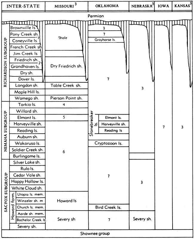
1. Or Wood Siding formation, including in upward order, Nebraska City limestone, unnamed shale, Pony Creek shale.
2. Or, in upward order, Morton limestone, Minesville shale, Palmyra limestone, Otoe shale.
3. Classification same as interstate, excepting as shown.
4. Tarkio limestone has been indicated as basal division of the Wabaunsee group in Missouri (Hinds and Greene, 1915; McQueen and Greene, 1938).
5. Called Elmont or Preston limestone by McQueen and Greene (1938).
6. Beds between Howard and Elmont limestone called Scranton by Hinds and Greene (1915).
7. Units incompletely differentiated and identified.
8. Nebraska recognized members of Burlingame limestone, in upward order, Taylor Branch limestone, Winnebago shale, South Fork limestone.
Exposures of Wabaunsee strata generally are more numerous and better suited for stratigraphic study of these rocks in the area south of the Kansas River. This is because country north of the Kansas River is extensively covered by glacial drift. Excellent sections of Wabaunsee strata are found in Shawnee, Osage, Lyon, Greenwood, Elk and Chautauqua counties, Kansas.
Outcrops of Wabaunsee rocks can be followed southward across west-central Osage County, Oklahoma. They are found also north of Kansas along the Missouri River in southeastern Nebraska and northwestern Missouri (Fig. 33), as well as in the area of the Table Rock anticline, farther west. Wabaunsee formations appear at the surface locally in southwestern Iowa, but glacial drift mostly covers these rocks in the Iowa, Nebraska, and Missouri region.
Figure 33. Distribution of outcrops of the Wabaunsee group in Kansas and parts of adjoining States. The belt forms the westernmost subdivision of the Pennsylvanian outcrop area.
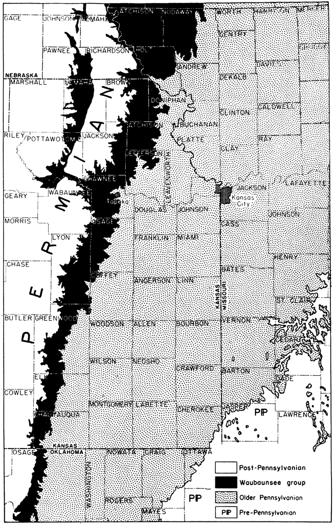
The thickness of the Wabaunsee group in Kansas shows little variation although the thickness of several of its contained formations shows a considerable range. Excepting places where the Indian Cave sandstone, at the base of the Permian System, cuts out the upper beds, the thickness of the Wabaunsee group is about 500 feet. Were the channel sandstone just mentioned occurs, the thickness of the group is reduced 80 to 125 feet.
Lithologic Character and Classification
The Wabaunsee group is distinguished chiefly by its general lithologic features and by the character of its cyclothems from the underlying Shawnee and the succeeding Lower Permian beds, but there are also some faunal peculiarities. Shale is relatively much more prominent in the Wabaunsee group than in adjoining parts of the geologic section (Figs. 34, 35). Much of the shale is sandy and at several horizons there are extensive sandstones. The Wabaunsee limestones are very persistent but are uniformly thin, the average thickness of individual members being only 2 to 3 feet. A distinctive feature of the Wabaunsee group is the character of the cyclic sedimentary succession, which shows regularly alternating nonmarine and marine units, in which (excepting beds at the base) a grouping of cyclothems in megacyclothems is not evident (Figs. 36, 37). This serves especially to set the Wabaunsee beds apart from those of the Shawnee group.
The Wabaunsee group is divided into alternating shale and limestone formations. The shales include shale, sandstone, coal, and some minor limestone beds which all together comprise the initial and terminal parts of adjoining cyclothems. The limestones contain limestones and intervening shales which represent the medial part of each cyclothem. This classification is applicable to all of the Wabaunsee beds except one or two seemingly rudimentary cyclothems, which are not separately indicated by the present defined formations. These formations also may be assigned to subgroups called Sacfox, Nemaha, and Richardson, which have been defined in Nebraska (Condra & Bengston, 1915; Condra, 1935). These are included in agreed interstate classification but use of them is not mandatory. This follows partly from the fact that units like the Tarkio limestone and Burlingame formation, which mark boundaries between the subgroups, are extremely inconspicuous or unrecognizable in parts of the midcontinent area. Thus, the Tarkio limestone cannot be identified south of Emporia, Kansas, although it is followed very readily in areas farther north.
Figure 34. Generalized columnar section of rocks belonging to the Sacfox subgroup, lower Wabaunsee, in Kansas. These rocks are late Virgilian in age.
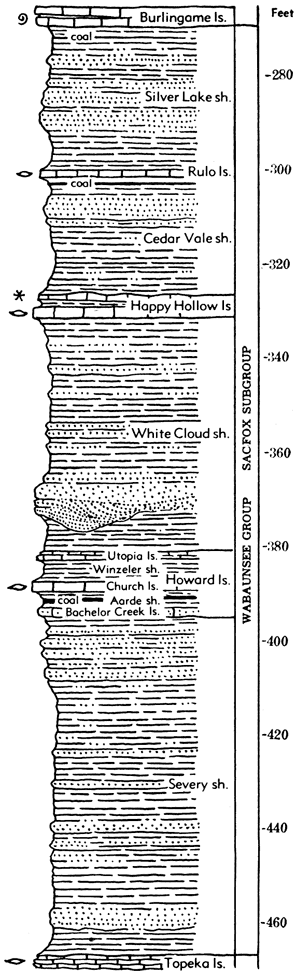
Sacfox Subgroup
General Description
The lower one third of the Wabaunsee strata, including formations upward to the base of the Burlingame limestone, is classed as belonging to the Sacfox subgroup (Fig. 32). This division can be followed readily across Kansas, inasmuch as the Burlingame makes a well-defined escarpment and extends from Nebraska into Oklahoma.
Average thickness of rocks assigned to this subgroup in Kansas is about 200 feet.
The Sacfox part of the Wabaunsee group includes the moderately thick Severy shale at the base, overlain by persistent escarpment making rocks of the Howard limestone. The overlying White Cloud shale, Happy Hollow limestone, Cedar Vale shale, Rulo limestone, and Silver Lake shale are weak rocks, generally, for the limestones are too thin to be expressed topographically in most places.
Severy Shale
The Severy shale (Haworth, 1898, p. 67), named from Severy in southern Greenwood County, Kansas, conformably overlies the Topeka limestone of the Shawnee group and includes the beds up to the base of the Howard limestone (Figs. 32, 34). Depending on variations in the development of the limestone members of these contiguous formations, the lower and upper boundaries of the Severy shale are drawn in different places at slightly different stratigraphic horizons. For example, where the Coal Creek member of the Topeka limestone is recognized, the base of the Severy is at the top of the Coal Creek limestone, but where the Hartford is the only identified member of the Topeka, the lower boundary of the Severy is considered to extend to the top of this limestone. Similar relationships are found in tracing the contact of the Severy and the Howard, but it is deemed proper to designate the section in some places, the Severy-Aarde indicating that the stratigraphic equivalent of the lower Howard shale member is believed to be present although the lower limestone is not and the Aarde has changed facies.
The Severy shale is chiefly a yellowish-brown and blue-gray sandy shale. Near the top, the shale grades into very evenly bedded thin layers of tan or buff sandstone separated by partings of sandy shale. This sandy zone is distinctive and widespread. The upper Severy sandstone is thicker, harder, and much more irregularly stratified in northern Oklahoma than in Kansas. Where the sandstone is soft and thin-bedded, the Severy forms a smooth slope along the Howard escarpment, extending down to the dip-slope plain on the top of the Topeka limestone. Calcareous beds are mostly lacking in the Severy shale. Fossils are not found in most of the Severy shale, but small brachiopods and some other invertebrates are abundant locally just below the Howard limestone.
The thickness of the Severy shale is rather constantly about 70 to 80 feet.
Howard Limestone
The Howard limestone (Haworth, 1898, p. 21) is a thin but extremely persistent formation overlying the Severy shale conformably (Fig. 32). It is named from the county seat of Elk County, Kansas. Except in northern Kansas where topographic expression of the stratified rocks is blurred by effects of glaciation, the outcrop of the Howard beds is marked by a distinct escarpment which is less prominent than that of the Burlingame-Wakarusa limestones or those of limestones in the Shawnee group, but is clearly differentiated in most places.
The most complete development of the Howard limestone shows the presence of three limestone members and two shale members (Fig. 34). These have been named (in upward order) Bachelor Creek limestone, Aarde shale, Church limestone, Winzeler shale, and Utopia limestone. The lithologic and faunal characteristics of the Howard will be described according to these members. The Howard sedimentary cycle seems to be intermediate between the typical megacyclothems of the Shawnee group and the simple cyclothems of the Wabaunsee group, in which no grouping into megacycles is evident.
The thickness of the Howard limestone ranges from about 8 to 30 feet.
Bachelor Creek limestone member. The lowermost member of the Howard limestone, the Bachelor Creek limestone (Moore, 1932, p. 94) is developed in southern Kansas southward from the type area of the member in Greenwood County (Fig. 34). It is also well developed, perhaps locally, in Lyon and Osage counties. It is a hard, somewhat sandy, impure, bluish-gray limestone, which ranges in thickness up to about 3 feet. The rock is massive, but on weathering breaks into irregular shelly fragments of yellowish-brown color. Fossils consist of crinoid stem fragments and a few brachiopods and bryozoans. The member is distinguished by lithologic characters and by its position below the Nodaway coal in the Aarde shale. The thickness of the Bachelor Creek limestone ranges up to about 4 feet.
Aarde shale member. Above the Bachelor Creek limestone and also defined from outcrops in Greenwood County, Kansas, is the Aarde shale member (Moore, 1932, p. 94) (Fig. 34). It is chiefly a bluish-gray to yellowish clayey and sandy shale about 3 to 10 feet thick. The very persistent Nodaway coal occurs in this member, locally near the base, elsewhere near the middle, and in a few places near the top. The coal has been identified at numerous exposures from Nebraska, Iowa, and northwestern Missouri across Kansas and extending 50 miles or more into Oklahoma. It ranges in thickness from an inch or two to about 2 feet. The bed is mined at various places in Missouri and in Osage County, south of Topeka.
Parts of the Aarde shale can be differentiated in upward order: (1) sandstone, (2) sandy shale, (3) gray clay shale, (4) underclay, (5) coal (Nodaway), (6) gray clay shale, (7) dark hard limestone, (8) black fissile shale, (9) gray marine clay shale. The cyclic sequence is somewhat like that in the Cherokee rocks and the limestone (7), which seems out of place in a "Cherokee" cyclothem, is lithologically similar to limestones occurring next below black shales in Marmaton cycles or to "middle limestones" in Shawnee megacycles. Fossil plants are collected from the shale beds immediately below or above the coal at a number of places, and a marine fauna consisting of pelecypods and a few kinds of calcareous brachiopods occurs rather commonly in the uppermost gray shale.
Church limestone member. The most persistent and important limestone member of the Howard formation is named the Church limestone (Condra, 1927, p. 54) from outcrops in Pawnee County, Nebraska (Fig. 34). This limestone overlies the Aarde shale or, where the Bachelor Creek limestone is absent and Aarde shale cannot be differentiated, it is considered as forming the basal unit of the Howard, resting on Severy-Aarde shale.
The lithologic and faunal characters of the Church limestone are remarkably constant throughout its outcrop from Nebraska and Iowa to north-central Oklahoma. The color of the unweathered limestone is rather dark-blue to blue-gray. On weathering, a zone a few inches thick adjacent to exposed surfaces is altered to drab or brownish-blue and a thin coating of rich chestnut brown color is developed over the surface. The rock is very hard, dense, and brittle, breaking with a subconchoidal fracture when struck by a hammer. Commonly, the Church is a single massive bed. Along the outcrop in most places rectangular joint blocks, somewhat rounded at the edges by solution, are separated from the rock in place.
The most common fossils are crinoid stem fragments and large productids belonging to the genus Dictyoclostus. Specimens of Enteletes are common in the Bird Creek (Church) limestone in northern Oklahoma. The fossils are scattered at random through the fine-grained matrix. Large specimens of "Cryptozoon" are noteworthy in some exposures. At the top of the limestone is a thin crust containing very abundant bryozoans, especially Rhombopora and Streblotrypa. Fusulinids occur sparsely in the upper part of the Church limestone in southern Kansas and northern Oklahoma, but near Topeka fusulinids are abundant.
The thickness of the Church limestone ranges from about 1.5 to 6 feet, the average being a little more than 2 feet.
Winzeler shale member. Conformably above the Church limestone is the Winzeler shale (Moore, 1932, p. 94), named from Greenwood County, Kansas (Fig. 34). It is about 3 to 8 feet thick, bluish-gray or yellowish and clayey to calcareous. The lower part contains a marine fauna in which a variety of bryozoans and a few brachiopods are most common. This member is recognizable from Nebraska and Iowa southward to Oklahoma, but locally where the overlying limestone disappears, the Winzeler cannot be differentiated from the White Cloud shale; the combined unit is termed Winzeler-White Cloud shale.
Utopia limestone member. The uppermost member of the Howard limestone, occurring between the Winzeler shale and White Cloud shale, is called the Utopia limestone (Moore, 1932, p. 94) from a town in Greenwood County (Fig. 34). It is a rather thin, but persistent unit which differs lithologically and in faunal content from other limestone beds of the Howard formation. In central and southern Kansas the Utopia member is a single hard bed of dense rather dark bluish limestone which breaks along vertical joint planes into rectangular blocks. The color of the weathered rock is light brownish-gray. Exposed surfaces are slightly rough because of etching by solution that leaves fine horizontally disposed platy fragments of shells and algal growths standing in relief. This textural feature and the abundance of algal material called Osagia are distinguishing characters of this phase of the Utopia limestone. From Osage County northward the Utopia limestone is divisible into several limestone beds that are lithologically different and are separated by shale beds, one of which, at least, is black and fissile and bears abundant ostracodes. Two or more cyclothems seem to be represented. A variety of brachiopods, bryozoans, and some mollusks is observed at northern outcrops.
The thickness of the Utopia limestone ranges from less than 1 foot to a known maximum of about 15 feet in Osage County.
White Cloud Shale
The White Cloud shale (Condra, 1927, p. 58; 1930, p. 53) includes beds occurring between the top of the Howard limestone and the base of the Happy Hollow limestone (Figs. 32, 34). It is named from a place in Doniphan County, northeastern Kansas. The formation consists of bluish or yellow-brown clayey and sandy shale 30 to 80 feet in thickness. Locally, beds of shaly to massive sandstone occur in the upper part, and north of Topeka, channel sandstone associated with a foot or two of moderately coarse conglomerate at the base, occurs below the middle of the White Cloud shale. These sandy and conglomeratic deposits are interpreted as the initial phase of the Happy Hollow cyclothem. Fossils are rare or absent at most outcrops of the White Cloud shale. Both marine invertebrates, chiefly mollusks, and land plant remains have been observed. The White Cloud shale is traceable from Iowa and Nebraska entirely across Kansas into Oklahoma.
Happy Hollow Limestone
The Happy Hollow limestone (Condra, 1927, p. 58) occurs conformably above the White Cloud shale and lies next below the Cedar Vale shale (Figs. 32, 34). It is the so-called "salmon bed," distinguished by a peculiar salmon-yellow or pinkish-brown color, noted by various geologists along the Missouri River in northwestern Missouri, northeastern Kansas, and southeastern Nebraska. Its type locality is in Doniphan County, Kansas.
The Happy Hollow limestone consists typically of a single massive bed of pinkish-brown, somewhat impure limestone which weathers in rounded or irregularly porous surfaces. At some places it is very sandy, soft, and somewhat shaly, so that its outcrop is difficult to trace. The presence of abundant robust Triticites is a common feature. Some sections show clearly an upper part of the limestone which lacks fusulinids and most other invertebrates but contains Osagia and other algal material. This part of the formation, which clearly represents the regressive algal-molluscan limestone phase of the cyclothem, appears to rest disconformably on the fusulinid-bearing limestone, the contact being sharp and irregular. Locally there is a little shale between these two limestone phases. A dark bluish limestone containing mollusks, brachiopods, and bryozoans has been observed a foot or two below the fusulinid limestone at some places.
The thickness of the Happy Hollow limestone ranges from about 1 foot to 7 or 8 feet. It extends from Cass County, Nebraska, at least to southern Osage County, Oklahoma. Its distinctive lithologic and faunal characters make it a useful horizon marker.
Cedar Vale Shale
The Cedar Vale shale (Condra, 1930, p. 53), named from western Chautauqua County, Kansas, comprises the middle part of the interval formerly termed Scranton shale (Figs. 32, 34). The top of the Happy Hollow limestone forms its lower boundary and the base of the Rulo limestone its upper boundary. The Cedar Vale shale is bluish to yellowish brown, includes clayey and sandy beds and near the top contains the very persistent Elmo coal. At many places the few feet of beds underlying this coal consists of soft shaly sandstone or of hard fairly massive sandstone. The sandstone, sandy shale, and coal in the upper part of the Cedar Vale represent the initial, terrestrial deposits of the Rulo cyclothem. Fossils are uncommon in most parts of the Cedar Vale shale. The topmost beds, between the Elmo coal and the base of the Rulo limestone, contain a fauna of marine mollusks, brachiopods, and bryozoans.
The thickness of the Cedar Vale shale averages about 25 feet. The formation is traceable from southern Nebraska to northern Oklahoma.
Rulo Limestone
The Rulo limestone (Condra & Bengston, 1915, p. 14) overlies the Cedar Vale shale and underlies the Silver Lake shale (Figs. 32, 34). The limestone can be recognized by its lithologic characters and position just above the Elmo coal and between the Happy Hollow and Burlingame limestones.
The Rulo limestone is a bluish-gray rock in fresh exposures and appears in some cases faintly mottled with irregular light-brownish areas. The limestone weathers brown or dark-gray. In general, it appears as a single massive bed that breaks along joints into fairly large rectangular blocks. A tendency to disintegrate in small chips is observed in some exposures, and locally the bed is distinctly shaly. Argillaceous, silty or sandy impurities are commonly present. Fossils are abundant in some outcrops but are few in others. Brachiopods and bryozoans are most common. Small fusulinids have been observed in a few places. The presence of a transgressive molluscan phase is indicated by occurrence of numerous pelecypods at the base in some exposures and a thin zone of algal limestone at the top locally marks the regressive algal-molluscan phase of the typical cycle. In general, however, the different calcareous elements of the cyclothem are not well differentiated in the Rulo limestone.
The thickness of the Rulo averages about 2 feet. The bed is identified at many places from its type locality in southeastern Nebraska to northern Oklahoma.
Silver Lake Shale
The Silver Lake shale (Beede, 1898, p. 30; Condra, 1927, p. 58), named from outcrops west of Topeka, Kansas, includes strata between the Rulo limestone, below, and the Burlingame limestone, above (Figs. 32, 34). It is somewhat variable in lithologic character, in some places consisting chiefly of bluish-gray and yellowish clay shale, with or without platy impure beds of limestone, and in other places being composed largely of light yellowish-brown sandy shale and shaly sandstone. Locally a coal bed occurs in the upper part of the shale. Some outcrops of the Silver Lake shale yield remains of land plants and some show fairly abundant marine mollusks, brachiopods, bryozoans, and other invertebrates. These kinds of fossils reflect different phases in the sedimentary cycle. Two or more dissimilar fossil zones may be seen in a single exposure of the shale.
The thickness of the Silver Lake shale averages about 25 feet. The formation is traced from Nebraska across Kansas into northern Oklahoma.
Nemaha Subgroup
General Description
The middle part of the Wabaunsee group, which is designated as the Nemaha subgroup in Nebraska, contains formations from the base of the Burlingame limestone to the top of the Tarkio limestone (Fig. 32). This division can be traced southward in Kansas as far as central Lyon County, in the vicinity of Emporia, but because the Tarkio limestone is not identified farther south, the subgroup is not recognized in southern Kansas.
Limestones of the Nemaha subgroup are generally good escarpment-makers, and in this respect the middle Wabaunsee is rather well differentiated from the lower and upper divisions. Only the Howard limestone in the lower Wabaunsee and only the Dover limestone in the upper Wabaunsee are persistently well expressed topographically. On the other hand, each of the Nemaha limestones commonly makes a well-defined bench.
Average thickness of the Nemaha subgroup in Kansas is about 160 feet.
Formations assigned to this subgroup include (in upward order): Burlingame limestone, Soldier Creek shale, Wakarusa limestone, Auburn shale, Reading limestone, Harveyville shale, Elmont limestone, Willard shale, and Tarkio limestone.
Figure 35. Generalized columnar section of rocks belonging to the Nemaha and Richardson subgroups, Wabaunsee group, in Kansas. These rocks comprise the uppermost part of the Virgilian Series in the northern midcontinent region. The unconformity which marks the boundary between Pennsylvanian and Permian rocks is indicated.
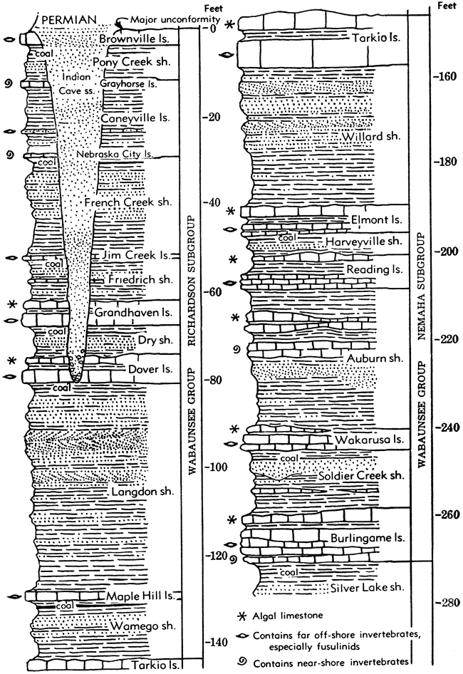
Figure 36. Sections of Wabaunsee beds showing cyclothems. Corresponding phases of the cyclothems are correlated. The stratigraphic position of the cyclothems is indicated in the general section at right in Figure 37. Algal-molluscan limestone beds are shaded.
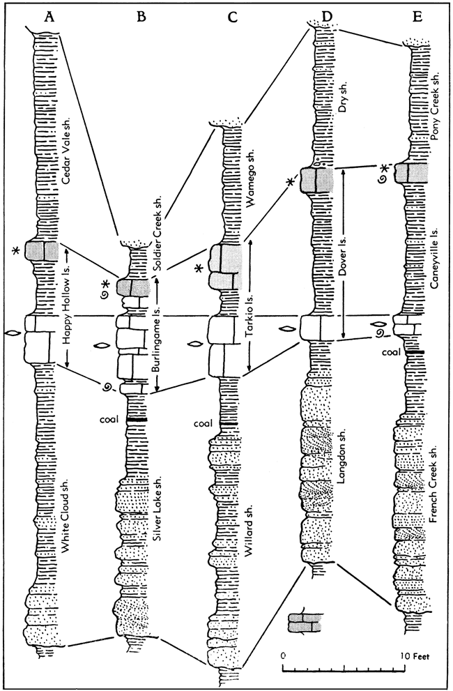
Figure 37. Sections of Wabaunsee beds showing cyclothems. Algal-molluscan beds are shaded.
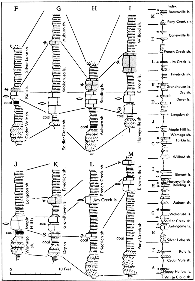
Burlingame Limestone
The Burlingame limestone (Hall, 1896, p. 105), which occurs next above the Silver Lake shale, is one of the most prominent scarp-makers in the Wabaunsee group (Figs. 32, 35, 36). It was one of the first units to be named in the course of work by the Haworth Survey, the type locality being located in central Kansas.
The Burlingame limestone is chiefly distinguished by its strongly brown color and thick bedding. The rock is hard, medium- to fine-grained, and is commonly rather unfossiliferous. Many exposures show a peculiar mottled color and apparently brecciated structure, with irregularly shaped fragments of dense gray or light brownish limestone in a matrix that becomes very dark brown on weathering. This type of rock is generally somewhat porous, and it may contain numerous fine calcite veins and other markings. Some beds of the Burlingame are light-gray and rich in fossils, but the color of the weathered rock is brown.
Different kinds of limestone and assemblages of fossils, which represent certain parts of the sedimentary cycle, are seen in the Burlingame formation, but the development of these phases is very unequal from place to place. At the base of the formation locally is limestone containing abundant pelecypods and a few brachiopods such as Derbyia and Juresania but no fusulinids. This clearly represents the transgressive molluscan phase of the cyclothem. A few inches of shale overlies the molluscan limestone, or limestone with fusulinids occurs next without a shale parting. The fusulinids of the Burlingame are mostly small and may easily be overlooked. There are many outcrops of Burlingame, however, which lack fusulinid-bearing beds. A very important element of the formation as observed in most places is the limestone classed as the regressive, algal-molluscan phase of the cyclothem. This includes the massive apparently brecciated rock at many outcrops; beds that contain abundant Osagia and other algal material; thin-bedded platy, very dense limestone which is unfossiliferous; molluscan limestone containing well-preserved fossils; and locally, conglomeratic limestone (Fig. 36). Many gastropods are found in this part of the Burlingame. In northern Kansas, a remarkable development of algal limestone of two or three sorts occurs at this horizon. One of these consists of beds and local "reefs" of subspherical, sponge-like bodies, an inch to 4 or 5 inches in diameter. Interpreted by Beede as sponges, he named them Somphospongia, but they are believed to be algal.
The thickness of the Burlingame limestone ranges from about 4 to 16 feet, the average being about 8 feet. The formation has been mapped from southern Nebraska across Kansas and has been identified 40 miles or more south of the Kansas-Oklahoma line.
Soldier Creek Shale
The Soldier Creek shale (Beede, 1898, p. 30; Condra, 1927, p. 77) overlies the Burlingame limestone and underlies the Wakarusa limestone (Figs. 32, 35, 36, 37).
It is a bluish-gray to bluish, clayey to sandy or silty micaceous stratigraphic unit that locally contains a little sandstone. Locally, also, a thin coal bed occurs in the upper part of the shale, but in most places this is absent. Fossils are not common. In a few places there are marine invertebrates at the top of the shale just below the Wakarusa limestone. The Soldier Creek is 15 to 25 feet thick in southern Nebraska and part of northern Kansas, but near Kansas River and southward for many miles it is less than 6 feet thick. In southern Kansas this shale is 12 to 18 feet in thickness.
Wakarusa Limestone
The Wakarusa limestone (Beede, 1898, p. 30; Condra, 1927, p. 66), named from outcrops southwest of Topeka, comprises the first resistant unit above the Burlingame limestone (Figs. 32, 35, 37). The most persistent and distinctive element in the Wakarusa formation is a thick-bedded or massive dark bluish hard limestone which contains large fusulinids, algae of the type called Ottonosia, a robust Dictyoclostus, crinoid stem fragments, Fistulipora, and a varied assemblage of other brachiopods, bryozoans, and some additional groups of invertebrates. On weathering the Wakarusa becomes mottled gray and light-brown or the rock is changed entirely to brown. Both lithologic and faunal characters serve readily to distinguish the Wakarusa limestone from the underlying Burlingame and it can be differentiated from somewhat similar lithologic phases of the Reading and Elmont limestones by observation of stratigraphic position and faunal characters. The thickness of the Wakarusa limestone ranges from about 2 feet to about 18 feet, the latter thickness including somewhat more shale than limestone. The formation is traceable from Nebraska into northern Oklahoma.
The so-called "Cryptozoon limestone" of Osage County, Oklahoma, which is a widely recognized datum in this part of the Pennsylvanian column in northern Oklahoma, is the fusulinid-bearing phase of the Wakarusa limestone.
Auburn Shale
The Auburn shale (Beede, 1898, p. 30; Condra, 1927, p. 78), named from southern Shawnee County, Kansas, includes the strata between the top of the Wakarusa limestone and the Reading limestone (Figs. 32, 35, 37). It is a more complex unit than most of the shale formations of the Wabaunsee group, for it includes not only the terminal clastic portion of the Wakarusa cyclothem and the initial clastic part of the Reading cyclothem, but several identifiable phases of what seems to be a partially developed intermediate cyclothem.
The lowermost part of the Auburn consists of yellowish-brown or gray sandy shale, mostly lacking in fossils. The lower part of a cyclothem belonging above the Wakarusa is clearly marked by sandstone or red shale and locally by coal and underclay in the lower part of the Auburn shale. These nonmarine deposits are overlain by shale and thin even-textured fine-grained blue limestone beds that contain marine pelecypods and commonly the brachiopod Linoproductus. Other brachiopods, bryozoans, and crinoid remains are fairly abundant in the shale at some exposures. A blocky, somewhat impure limestone about 0.4 to 0.5 feet thick with very even top and bottom, is identified in this zone entirely across Kansas and in northern Oklahoma. It is underlain by a thin platy limestone which carries plant fragments and some pelecypods. The persistence and uniformity of characters of these thin layers for scores of miles along the outcrop is very striking and the horizon is a very useful stratigraphic marker.
No fusulinid-bearing limestone beds have been observed in the middle part of the Auburn shale but in Shawnee County there is a locally prominent limestone containing abundant molluscan and algal remains. Near Kansas River this limestone is a resistant scarp-making limestone, 5 feet thick. It is coquinoid and in part conglomeratic and cross-bedded. Very dark, nearly black clay shale just beneath this limestone in some outcrops contains a fauna of well-preserved pectinoid and other pelecypods and a profusion of large ostracodes.
The upper part of the Auburn shale contains persistent platy sandstone 1 to 3 feet thick. The overlying shale contains remains of mollusks, chiefly pelecypods, and some brachiopods. A thin coal horizon belongs at the base of this zone.
The thickness of the Auburn shale ranges from about 20 to 70 feet. The formation is identified in Nebraska and is continuous southward across Kansas into Oklahoma.
Reading Limestone
The Reading limestone (Smith, 1905, p. 150), named from eastern Lyon County, Kansas, includes one to three beds of limestone and the shale between these beds (Figs. 32, 35, 37). The formation rests on the Auburn shale and is followed by the Harveyville shale. The Reading comprises the lower part of the beds which previously have been called Emporia limestone, or in northern Oklahoma, the Stonebreaker limestone.
The most persistent subdivision of the Reading limestone is a fusulinid-bearing unit consisting of one to three or four layers of dark-blue, fine-grained, dense, hard limestone which shows prominent vertical joints. The weathered rock is light bluish-gray mottled or blotched with light brownish or lemon-yellow areas. In places the entire thickness of the fusulinid-bearing member is yellowish brown. Fossil fragments weather in relief. Fusulinids are abundant in this part of the Reading limestone occurring with or without other types of invertebrates. A limestone bed containing numerous pelecypods and some brachiopods occurs in some outcrops below the fusulinid-bearing limestone. The distinguishing feature of the uppermost member is the presence of Osagia or other algal remains accompanied by some mollusks. Fusulinids are absent. The shale beds between limestones of the Reading formation commonly are blue-gray and clayey to calcareous, but in southern Kansas coal underlain by black shale and overlain by gray shale occurs next below the fusulinid-bearing limestone. In places marine fossils are found in the shale.
The thickness of the Reading limestone ranges from about 1.5 feet to 15 feet. The formation is continuous from southern Nebraska to northern Oklahoma, being represented in the latter region by the lower part of beds classed as the Stonebreaker limestone.
Harveyville Shale
The Harveyville shale (Moore, 1936, p. 226) is named from southern Wabaunsee County, Kansas. It includes the beds between the Reading and Elmont limestones (Figs. 32, 35, 37). The shale is mostly bluish or yellowish-brown and clayey, but locally there is sandy shale and thin, platy sandstone. A coal bed occurs locally above the sandstone. Pelecypods and some other invertebrates are found between the coal horizon and the base of the Elmont limestone.
The thickness of the Harveyville shale ranges from less than a foot in a few places to an observed maximum of about 25 feet. The shale is identified from Nebraska to Oklahoma.
Elmont Limestone
The Elmont limestone (Beede, 1898, p. 30) comprises the upper part of the Emporia limestone of some early reports. It lies between the Harveyville shale and the Willard shale (Figs. 32, 35, 37). Exposures in the vicinity of Elmont, Kansas, show a strong development of the algal-molluscan phase but the fusulinid-bearing phase is poorly developed. Elsewhere, especially in southern Kansas, the fusulinid limestone is prominent. It is a dense, hard, dark-blue rock, very much like the Reading limestone, but it commonly bears much more closely spaced vertical joints and it is typically a single massive bed which weathers light bluish. In southern Shawnee County the lowest Elmont member is a dense, very fine-grained unfossiliferous blue limestone containing round pebbles of limestone slightly different in color and texture from the matrix.
The thickness of the Elmont limestone ranges from about 1 to 15 feet. The formation is traced from Nebraska across Kansas to northern Oklahoma where it has previously been included as the upper part of the Stonebreaker limestone.
Willard Shale
The Willard shale (Beede, 1898, p. 31) is defined to include the beds lying between the Elmont and Tarkio limestones (Figs. 32, 35, 37). South of the point in Lyon County where the Tarkio limestone disappears, the Willard is overlain by the Wamego shale and the combined shale unit is designated as the Willard-Wamego shale. South of Emporia the Maple Hill limestone likewise disappears, so that there is a continuous shale and sandstone section from the base of the Willard to the top of the Langdon shale. This combination of shales which are distinct in the north is called Willard-Langdon shale in southern Kansas.
The Willard shale includes the upper part of the Elmont cycle and the lower part of the Tarkio cyclothem. The boundary between these cycles is marked in some sections by the contact between clayey or sandy shale in the lower part of the Willard and massive light-tan sandstone in the upper part. The sandstone is prominent at many places in northern Kansas and southern Nebraska but it thins and disappears toward the south. This is a departure from the general rule that sandy deposits become more prominent southward and that clastic units are thicker in the south than in the north. Near the Kansas-Oklahoma line the section from the top of the Elmont limestone to the base of the Dover limestone is about 40 feet thick and is largely sandstone with a coal bed near the base. The color of the Willard shale is mostly dark bluish and brown. Fossils are not common.
The thickness of the Willard shale ranges from about 30 to 60 feet in northern Kansas and southern Nebraska, maximum thickness being observed near Kansas River.
Tarkio Limestone
The Tarkio limestone (Calvin, 1901, p. 420, Condra & Bengston, 1915, p. 9) is a distinctive formation that occurs next above the Willard shale and beneath the Wamego shale (Figs. 32, 35, 36). As indicated by the name used by Swallow in 1867, "Chocolate limestone," the rock typically weathers to a very strong brown color, which, however, is somewhat more yellow in hue than chocolate. The name Tarkio is derived from northwestern Missouri and was applied originally to a bed below the limestone which is now known as Tarkio. Usage has fixed application of the name firmly to the unit here described.
The Tarkio limestone is moderately hard and in most outcrops appears as a single massive bed. It breaks down in irregularly shaped Shelly slabs. Except locally the thickness and resistance of the formation are sufficient to produce a well-defined escarpment. Aside from lithologic features, the most prominent character of the Tarkio limestone is the presence almost everywhere of extremely abundant large ventricose fusulinids (Triticites sp.) which weather in relief, and because of their nearly white color, appear in strong contrast to the brown matrix. This feature is so striking and so unlike most other limestones in this part of the section that it is possible to identify exposures of Tarkio very easily. Some outcrops of this limestone show a gray color and these resemble in appearance certain exposures of the Dover limestone which also contains abundant large fusulinids. Above the fusulinid-bearing limestone there is present in some outcrops a few inches to 4 or 5 feet of algal limestone that lacks fusulinids but contains mollusks and some brachiopods. This represents the algal-molluscan phase of the cyclothem. It is not a persistent unit.
The Tarkio limestone ranges in thickness from less than a foot in a few places to a maximum of about 10 feet, as seen in the vicinity of Maple Hill in eastern Wabaunsee County, Kansas. The formation is traced from Nebraska southward to northern Lyon County, Kansas, but no outcrops identifiable as Tarkio have been found farther south.
Richardson Subgroup
General Description
The Richardson subgroup, defined in Nebraska, comprises the upper part of the Wabaunsee group, from the top of the Pennsylvanian section down to the Tarkio limestone (Figs. 22, 32, 35). This division can be distinguished in northern Kansas but not south of the Cottonwood River Valley in Lyon County. The Tarkio limestone disappears, or if present, has not been identified in the country south of Emporia. Generally, the upper Wabaunsee section lacks hard rocks having sufficient thickness to be expressed topographically.
Average thickness of the Richardson subgroup is about 140 feet.
Formations assigned to the upper part of the Wabaunsee section, called Richardson, include six limestone units and six consisting predominantly of shale: Wamego shale, Maple Hill limestone, Langdon shale, Dover limestone, Dry shale, Grandhaven limestone, Friedrich shale, Jim Creek limestone, French Creek shale, Caneyville limestone, Pony Creek shale, and Brownville limestone. Each of these formations, as well as some of its subdivisions, is traceable across Kansas.
Wamego Shale
The Wamego shale (Condra & Reed, 1943, p. 42), named from a town on Kansas River east of Manhattan, comprises beds lying between the Tarkio and Maple Hill limestones (Figs. 32, 35, 36). It consists of bluish clay shale and yellowish-brown sandy, micaceous shale, the total thickness ranging from about 6 to 25 feet. Locally in the north the upper portion is nearly black. A persistent zone of shaly to thin-bedded tan or buff sandstone, 1 to 4 feet thick, appears in the upper middle part of the shale in Kansas. The sandstone marks the initial phase of the Maple Hill cyclothem. Above the sandstone, near the top of the shale, is a coal bed that in places attains a thickness of nearly a foot. It is observed at most outcrops between the Kansas and Cottonwood rivers in Kansas. Marine fossils, consisting of pelecypods, brachiopods, and bryozoans chiefly, occur above the coal but other parts of the Wamego shale are mostly unfossiliferous. Some of the historically famous Nebraska City fossils, described in early writings by Geinitz (1866) and by Meek (1872), come from the Wamego shale.
South of the point where the Tarkio limestone disappears, the Wamego rests directly on the Willard shale and because it is not practicable to separate these contiguous, lithologically similar units, the shale between the Elmont and Maple Hill limestones, about 90 feet thick near Emporia, is termed Willard-Wamego shale. South of Emporia where the Maple Hill limestone also disappears there is a continuous shale section from the Elmont limestone to the Dover limestone. This shale may be called Willard-Langdon shale. It contains some sandstone beds, one of which is probably a continuation of the sandy zone in the Wamego shale, but it is not possible to differentiate the Wamego shale. The coal bed of the upper Wamego has not been observed south of northern Lyon County.
Maple Hill Limestone
The Maple Hill limestone (Condra, 1927, p. 80) consists in most places of a single bed of bluish-gray, somewhat sandy limestone, 1 to 4 feet thick (Figs. 32, 35, 37). It is defined on the basis of excellent exposures near the town of Maple Hill, west of Topeka. The limestone is fairly hard and commonly forms a bench a little above the escarpment of the Tarkio limestone. The rock is intersected by two or more systems of rather widely spaced vertical joints and in some places there are large rectangular or rhomb-shaped blocks along the outcrop. The joints are locally much enlarged by solution. On weathering the Maple Hill limestone commonly appears reddish-brown but in some places it is rather a brownish-gray. Fossils are rare in some outcrops of the Maple Hill, but in others they are abundant. Small slender fusulinids are very common in the southern part of the outcrop area but not in the north. Crinoid stem fragments, several kinds of brachiopods and bryozoans, and a few pelecypods and gastropods may be found at most exposures of this limestone.
The Maple Hill limestone extends from Emporia northward into Nebraska. Because the Wamego shale is much thinner, on the average, than the Langdon shale, the outcrop of the Maple Hill is closer to that of the Tarkio than to the Dover escarpment. At Emporia, however, the Maple Hill limestone is less than 5 feet below the Dover limestone, and in Lyon County these limestones form a single escarpment. The Maple Hill bed is readily distinguished by lithologic and faunal characters from the Tarkio and Dover limestones.
Langdon Shale
The Langdon shale (Condra & Reed, 1943, p. 42) includes the strata that occur between the Maple Hill and Dover limestones (Figs. 32, 35, 37). The shale is largely bluish-gray in color, and clayey to sandy in character. In many places the upper part of the formation consists of tan or buff sandstone which is shaly, platy, or fairly massive. This sandstone is the basal phase of the Dover cyclothem. The underlying shale contains marine fossils in many places and represents the terminal part of the Maple Hill cyclothem. This horizon furnished part of the famous Nebraska City fossil collections described by Geinitz in 1866 and by Meek in 1872. The fauna is by no means so varied or the specimens so abundant as in many other Pennsylvanian formations of Nebraska and Kansas. Near the top of the Langdon shale is a widely persistent thin coal bed that is locally worked in Missouri and Iowa. It is known as the Nyman coal. The coal extends almost uninterruptedly across southeastern Nebraska and northern Kansas and is recognized locally in southern Kansas.
The Langdon shale ranges in thickness from about 25 feet in southern Nebraska to 50 feet or more in Wabaunsee County, Kansas. Southward from this region the thickness gradually diminishes until at Emporia less than 5 feet of shale separates the Maple Hill and Dover limestones. South of Emporia, Langdon is not separable from underlying shale that represents the Wamego and Willard shales of areas to the north. This combined shale section which is about 100 feet thick near Emporia thins southward to about 15 feet in parts of Chautauqua County, Kansas.
Dover Limestone
The Dover limestone (Beede, 1898, p. 31) is an important although thin formation that is traced from Oklahoma across Kansas and southern Nebraska into Iowa (Figs. 32, 35, 36). As observed at the type locality, a few miles southwest of Topeka, and at many other places in northern Kansas and Nebraska, the Dover most closely resembles the Tarkio limestone, perhaps mainly because both of these units contain an abundance of very large fusulinids. Very unlike the rich-brown color of the weathered Tarkio, however, the weathered Dover limestone is light-gray, and it is generally much softer than the Tarkio. Numerous large "Cryptozoon" growths, which are rare or absent in the Tarkio, are seen in most outcrops of the Dover. In much of northern Kansas only the fusulinid-bearing limestone is present, but south of Kansas River an algal bed with abundant Osagia and in places what seems to be other types of algal growths occurs above the fusulinid bed. Extending southward from Greenwood County there is a dense, fine-grained blue limestone carrying a mixed fauna of mollusks, brachiopods, and bryozoans, that appears a few feet below the fusulinid-bearing bed. The algal bed at the top of the Dover is very persistent and prominent in the southern area. The changes in the composition of the Dover limestone along the outcrop have been determined by detailed field work which includes mapping and the careful study of many sections.
The Dover limestone is about 2 to 4 feet thick in northern Kansas and Nebraska, but where the three limestone members are present in southern Kansas the formation is about 15 to 20 feet thick.
Dry Shale
The Dry shale (Moore, 1936, p. 236) comprises shaly beds, 5 to 20 feet or more thick, that separate the Dover limestone from the next higher limestone, the Grandhaven (Figs. 32, 35, 36, 37). The shale is bluish-gray and clayey for the most part, but sandy beds appear in places. A thin coal bed occurs near the top of the Dry shale in southern Kansas, the coal and sandy beds belonging to the Grandhaven cyclothem. The shale between the top of the coal and the base of the Grandhaven limestone is locally rich in marine fossils, calcareous brachiopods, and bryozoans being dominant.
The Dry shale is a well-defined stratigraphic unit from Shawnee County, Kansas, southward to the Oklahoma line, but northward it coalesces with the Friedrich shale above the Grandhaven limestone, for the Grandhaven disappears. It is possible--indeed, there is some explicit indication--that the Grandhaven beds grade laterally northward into shale, but it is not practicable to subdivide the shale section between the Dover and Jim Creek limestones. This may be designated, accordingly, as the Dry-Friedrich shale.
Grandhaven Limestone
The Grandhaven limestone (Moore, 1936) overlies the Dry shale and underlies the Friedrich shale (Figs. 32, 35, 37). It comprises the only persistent limestone beds that occur between the rather easily recognized Dover limestone, below, and the Jim Creek limestone, above. There are commonly two limestone members which are separated by a few feet of shale. The lower limestone is gray to bluish in color, and unlike the Dover, commonly weathers brown, in some cases a strong reddish-brown. It contains numerous fusulinids and some other invertebrates in some exposures, but elsewhere fusulinids are sparse or absent. Toward the south this limestone is thinner and finer grained, weathers shelly, and in many ways resembles outcrops of the Maple Hill limestone. There are numerous brachiopods, but few or no fusulinids. The changes in faunal character along the strike of this member are similar to those observed in corresponding phases of the Dover limestone, in which northern outcrops show abundant fusulinids and "Cryptozoon," but southern outcrops lack the fusulinids and retain numerous "Cryptozoon" remains. The upper limestone member of the Grandhaven formation is characterized by an abundance of algal deposits, mostly of the Osagia type. This bed so closely resembles some outcrops of the upper member of the Dover that it is easy to mistake one for the other unless attention is given to stratigraphic sequence. The algal bed of the Grandhaven limestone is very light-gray, weathering almost white, and in some exposures the prominent rounded algal growths give the rock a resemblance to conglomerate. The shale between the two limestones is mostly bluish-gray, and clayey to calcareous. Locally, the upper Grandhaven is strongly cross-bedded and it contains an abundant brachiopod and bryozoan fauna, in which are included also some mollusks.
The thickness of the Grandhaven limestone averages about 10 feet. The lower limestone is 2 to 5 feet in the north, but only 0.5 foot in the south. The upper limestone is 1 to 2 feet thick in most places, but locally attains a thickness of 8 feet or more. The intermediate shale is 4 to 10 feet thick. The Grandhaven limestone is recognized from Shawnee County southward to Oklahoma, but is not seen north of Kansas River. The formation clearly belongs to a cycle of sedimentation distinct from that of the Dover limestone.
Friedrich Shale
The Friedrich shale (Moore, 1936) includes clayey and sandy beds that lie between the Grandhaven and Jim Creek limestones (Figs. 32, 35, 37). The unweathered shale is chiefly bluish-gray, but outcrops of weathered shale commonly appear yellowish or brownish. Locally there is sandstone in the upper part of this zone and at least in southern Greenwood County a thin coal bed appears a little below the Jim Creek limestone. Myalina and other pelecypods and some brachiopods, bryozoans, and other marine fossils appear near the top of the Friedrich shale, but in some outcrops fossils are rare or absent.
The thickness of the Friedrich shale averages about 15 feet. The unit is clearly identifiable throughout the region in which the Grandhaven limestone is developed--that is from Shawnee County, Kansas, southward--but farther north where the Grandhaven is not seen, the shale lying between the Dover and Jim Creek limestones, may be called Dry-Friedrich shale.
Jim Creek Limestone
The Jim Creek limestone (Moore, 1936, p. 239) is a thin but surprisingly persistent fusulinid-bearing rock extending entirely across Kansas; a thickness of more than 2 feet has not been observed (Figs. 32, 35, 37). The Jim Creek is a useful horizon marker and it belongs to a sedimentation cycle that is distinct from those containing the adjacent Grandhaven and Caneyville limestones. Hence it is desirable, in spite of the thinness of the unit, to differentiate it as an independent formation. The Jim Creek limestone is fine-grained, hard, and bluish-gray or bluish in fresh exposure. The weathered rock is commonly brown and gray and in most cases there are reddish or purplish tones. The bed appears as a single massive layer that is vertically jointed, but on prolonged weathering there is a tendency for the rock to break down in small shelly chips. A large variety of marine fossils, including especially brachiopods, bryozoans, and pelecypods, is found in the Jim Creek limestone in some places.
French Creek Shale
The French Creek shale (Moore, Elias & Newell, 1934) comprises clayey and sandy beds between the Jim Creek and Caneyville limestones (Figs. 32, 35, 36, 37). The color is bluish-gray to yellowish-brown. The upper part commonly contains light brown or tan sandstone which locally is fairly hard, thick, and massive. This shale is variable in lithology but its lower part clearly represents the terminal part of the Jim Creek cycle, and its upper part, including sandstone beds, belongs to the Caneyville cycle. The Lorton coal occupies a position near the top of the French Creek shale. Although this coal bed is thin, it is one of the most widespread of the Late Paleozoic coal deposits of the northern midcontinent region. Above the coal and below the Nebraska City limestone member of the Caneyville formation there is a dark-colored shale with an abundant marine fauna characterized especially by large Myalina and Derbyia shells.
The thickness of the French Creek shale averages about 30 feet. The formation is recognized across all Kansas.
Caneyville Limestone
The Caneyville limestone (Moore, 1936) includes beds from the base of the limestone designated in some reports as Nebraska City to the top of the limestone called Grayhorse (Figs. 32, 35, 36). The Nebraska City limestone is a molluscan bed belonging to the transgressive part of a cyclothem for which no fusulinid-bearing phase was known until outcrops in Chautauqua County, Kansas, of this expected phase were discovered. Above the fusulinid-bearing limestone in Chautauqua County, is a fragmental, algal, and molluscan limestone, that clearly belongs to the regressive part of this cyclothem. It is traced southward into the Grayhorse limestone of Osage County, Oklahoma, and it was thus determined that the Nebraska City and Grayhorse limestones are parts of a single cyclothem which includes the unnamed fusulinid-bearing limestone between them in southern Kansas.
Nebraska City limestone member. The Nebraska City member (Condra, 1927, p. 116) of the Caneyville limestone is a bluish or greenish-gray sandy limestone that weathers light-yellowish brown (Figs. 35, 36). It is rather soft and does not make a prominent outcrop in most places. Brachiopods, bryozoans, and some mollusks are common in this bed. The stratigraphic position of the member with reference to the Jim Creek, Brownville, and other distinctive limestones in this part of the section, and the occurrence of a coal bed a few inches below the member, are the chief means of recognizing the Nebraska City limestone. This limestone ranges in thickness from less than 1 foot to about 5 feet, the average being about 1.5 feet.
The fusulinid-bearing limestone of the Caneyville cyclothem, is a bluish-gray, massive, slightly arenaceous bed with vertical joints. Few fossils other than long slender specimens of Triticites occur. The thickness of this limestone averages about 1 foot, and the maximum observed thickness is about 1.5 feet. It occurs 5 to 10 feet above the Nebraska City limestone.
Grayhorse limestone member. The Grayhorse member (Bowen, 1918, p. 138) of the Caneyville limestone is very different in appearance from the other two limestone members (Figs. 35, 36). It is medium- to coarse-grained, appears fragmental or coquinoid, and is rather strongly ferruginous. Broken surfaces of the unweathered rock commonly show curved cleavage surfaces of iron or magnesium-bearing carbonate crystals. In some exposures the bed appears massive but commonly there is distinctly evident cross-bedding. Large specimens of Myalina of the M. subquadrata type are the most common type of fossil. The Grayhorse limestone ranges in thickness from about 0.5 to 5 or 6 feet, the average being about 1 foot. This member occurs 5 to 15 feet above the fusulinid-bearing limestone.
The average total thickness of the Caneyville limestone is 15 to 20 feet. The formation extends from northern Oklahoma across Kansas to southern Nebraska.
Pony Creek Shale
The Pony Creek shale (Condra, 1927, p. 81; Moore, 1936, p. 243) comprises 5 to 20 feet of bluish and bluish-gray shale and locally some red clayey or sandy shale (Figs. 32, 35, 36, 37). The middle part locally contains some sandstone. The lower Pony Creek shale is mostly unfossiliferous, but the upper part commonly contains a variety of brachiopods and bryozoans, with Marginifera wabashensis and Chonetes granulifer among the most common species. A thin coal bed which belongs to the Brownville cyclothem appears in the upper middle part of the Pony Creek, just beneath the fossiliferous marine zone, in southern Kansas and northern Oklahoma. The Pony Creek shale extends entirely across Kansas and is well developed both in Nebraska and northern Oklahoma,
Brownville Limestone
The Brownville limestone (Condra & Bengston, 1915, p. 17) is a very widespread and distinctive formation that is here regarded as the uppermost stratigraphic division of the Wabaunsee group and of the Pennsylvanian System in Kansas (Figs. 32, 35, 37). At most places the Brownville consists of one or two beds of bluish-gray, hard limestone that weathers yellowish or somewhat reddish brown. Some outcrops show rock that appears impure and sandy, but in most places the limestone is fairly pure, dense, massive, and fine-grained. Commonly the Brownville limestone weathers in angular or rounded blocks or it disintegrates in irregularly shaped shelly fragments. The occurrence of abundant shells of Marginifera wabashensis characterizes most outcrops and in addition, exposures in Kansas commonly show the presence of fairly numerous large fusulinids, the bryozoan Meekopora, the brachiopod Chonetes granulifer, and crinoid stem fragments. Not infrequently these fossils occur in clusters or "nests" between which the rock contains only scattered fossils. A bed with algal and molluscan remains occurs above the fusulinid-bearing bed in parts of Chautauqua County, Kansas.
The Brownville limestone was named from outcrops in southeastern Nebraska. It has been traced entirely across Kansas and is known to extend at least 50 miles southward into Oklahoma. The thickness of the formation ranges from about 2 to 8 feet.
Prev Page--Upper Pennsylvanian, Missourian Series || Next Page--References
Kansas Geological Survey, Geology
Placed on web Jan. 26, 2009; originally published Nov. 1949.
Comments to webadmin@kgs.ku.edu
The URL for this page is http://www.kgs.ku.edu/Publications/Bulletins/83/07_up2.html