![]()
Prev Page--Introduction || Next Page--Definitions
Boundaries of the Pennsylvanian System in the Kansas Region
Mississippian-Pennsylvanian Boundary
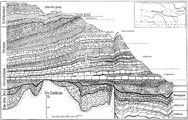
In Kansas and throughout the northern midcontinent area, excepting parts of Oklahoma and Arkansas, definition of the lower limit of Pennsylvanian rocks is one of the most evident in the rock succession (Fig. 3). Not only are the types of sedimentary rocks on opposite sides of the boundary very dissimilar generally, but there is evidence of pre-Pennsylvanian erosion of the underlying strata and varyingly prolonged break in sedimentation. The basal Pennsylvanian rocks rest on different parts of the Mississippian succession, from high in the system down to the bottom-most beds, and at many places, both at the outcrop in Missouri and in the subsurface of Kansas and Nebraska, the Pennsylvanian overlaps on to pre-Mississippian rocks. The oldest Pennsylvanian deposits in most of this territory are clearly much younger than rocks classed as belonging to the system elsewhere. Accordingly, there is no problem in marking the base of Pennsylvanian strata in the Kansas region.
Figure 3. Diagrammatic east-west section of rocks in Kansas showing prominent unconformity at base of the Pennsylvanian System. The section, drawn on the base of the Kansas City group as a datum, shows essential conformity of succession from Pennsylvanian into Permian parts of the section. (After Moore, Am. Assoc. Petroleum Geologists; data from section by Betty Kellett, Kansas Geol. Soc., 1932.) A larger version of this figure is available.
Pennsylvanian-Permian Boundary
Definition of the boundary between rocks classed as Pennsylvanian and Permian in the Kansas region has led to much debate and disagreement. Ulrich (1911, p. 376, pl. 26) proposed to avoid the difficulty by not recognizing Permian at all and by defining as Pennsylvanian all of the rocks between Mississippian and Triassic. This procedure might be defended on the basis of the stratigraphic succession in the midcontinent area, but it is evidently unsuited to world-wide application. Because beds having Pennsylvanian and Permian fossils lie parallel and are seemingly conformable in Kansas and adjoining states, attempts to define the base of the Permian in this area have been based chiefly on study of fossils. Consideration has been given also to lithologic features and the desirability of selecting a convenient cartographic datum. Judgment has been generally expressed that any adopted boundary is measurably arbitrary.
The general tendency during the 90 years since Permian deposits were first recognized in Kansas and in North America as a whole has been to lower the boundary farther and farther (Fig. 4).
Figure 4. Placement of the Pennsylvanian-Permian boundary in Kansas. Asterisks denote papers in which special consideration is given to the problem of stratigraphic classification. (After Moore, Am. Assoc. Petroleum Geologists.)
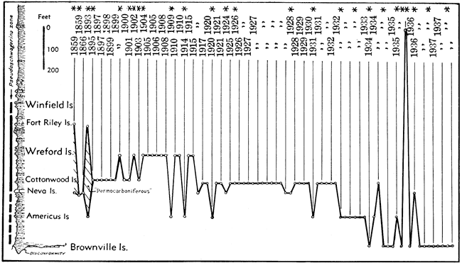
Mainly on account of the first appearance of the presumed Permian guide fossils Callipteris conferta and other plants at the horizon of the Wreford limestone in central Kansas, the lower Permian boundary was drawn at the base of the Wreford limestone by Adams, Girty, & White (1903), Prosser (1902, 1905), Haworth & Bennett (1008), and others. Owing, however, to the very evident lithologic and faunal similarity of beds extending for a considerable distance below and above the Wreford limestone, the base of the Cottonwood limestone, about 125 feet below the Wreford, originally chosen by Prosser (1895) as the basal boundary of the Permian, came later to be adopted generally. One reason for selection of this line seems to have been the fact that the Cottonwood is a persistent and distinctive stratigraphic datum that at a relatively early date had been traced entirely across Kansas into Nebraska and Oklahoma.
On the basis of discovery of species of "Schwagerina" (Pseudoschwagerina) in the Neva limestone, about 40 feet below the Cottonwood limestone, Beede & Kniker (1925) judged that the base of the Permian should be lowered to the base of the Neva limestone. This conclusion was reached from an extensive examination of paleontological characters in Russian and other sections of the world, from which it appeared that the zone of "Schwagerina" marks the introduction of marine faunas which are considered generally characteristic of Permian time.
One of the distinctive fusulinids of the Lower Permian, as previously defined in Kansas, is "Pseudofusulina" (Paraschwagerina). Because this fossil and various other invertebrates which are typical of Lower Permian as previously defined range downward to the Americus limestone, 150 feet below the Cottonwood limestone, and because lithologic features of beds below the Cottonwood to a horizon at least as low as the Americus are much more closely similar to overlying beds than to those of the Wabaunsee group, below, Moore (1932) concluded that if the Cottonwood and Neva are classifiable as Permian, the lower boundary of the Permian rocks in Kansas should be placed at least as low as the base of the Americus limestone. Placement of the Pennsylvanian-Permian boundary at this horizon had previously been proposed by Beede (1909, 1914) (Fig. 4). In the course of detailed stratigraphic studies and mapping of beds belonging below the Americus, evidence of the existence of a stratigraphic break comparable to the disconformities which separate the Desmoinesian, Missourian, and Virgilian divisions of the Pennsylvanian System, was discovered and traced from southeastern Nebraska to northern Oklahoma (Moore & Moss, 1934). This disconformity belongs just above the Brownville limestone but in places depressions are carved into upper Wabaunsee strata reaching more than 100 feet below the horizon of the Brownville. Work by Newell and others in Oklahoma indicates that the horizons of this disconformity can be followed southward to the vicinity of the Arbuckle Mountains. Accordingly, this boundary, about 275 feet below the Cottonwood limestone, has been designated as the line of division between Pennsylvanian and Permian (Moore, Elias & Newell, 1934). Evidence supporting the definition of this line as the lower boundary of rocks classed as Permian in the northern midcontinent area lies in conditions observed in western Texas where Wolfcampian beds, containing "Pseudoschwagerina" and "Pseudofusulina", rest with strong angular unconformity on upper Pennsylvanian beds (King, 1934). A detailed review of the fluctuating placement of the Pennsylvanian-Permian boundary in the Kansas region and in the north-central Texas and Trans-Pecos Texas areas has been published by Moore (1940) (Fig. 4).
Since the revision based on finding the disconformity just above the Brownville limestone, the Pennsylvanian-Permian boundary has been drawn uniformly by geologists of Kansas, Nebraska, and Oklahoma at this horizon. The boundary was recognized by the state geologists of Iowa, Kansas, Missouri, Nebraska, and Oklahoma in their conference of May 5-6, 1947, although basal Permian sandstone (Indian Cave) barely reaches into the northwestern corner of Missouri and the southwestern corner of Iowa.
Prev Page--Introduction || Next Page--Definitions
Kansas Geological Survey, Geology
Placed on web Jan. 26, 2009; originally published Nov. 1949.
Comments to webadmin@kgs.ku.edu
The URL for this page is http://www.kgs.ku.edu/Publications/Bulletins/83/03_bound.html