![]()
Prev Page--Lower Pennsylvanian || Next Page--Upper Pennsylvanian
Middle Pennsylvanian Rocks
General Description
Rocks classified as Middle Pennsylvanian comprise the oldest deposits of the system having very widespread geographic distribution. They occur not only in the belt of thick sedimentation of the southern Oklahoma and Arkansas geosyncline but extend uninterruptedly northward across the stable platform area in Oklahoma into Kansas and states farther north. Evidence for segregation of this part of the system, classed as the Oklan Series by Moore & Thompson (1949), consists of well-marked physical breaks below and above and excellent paleontological testimony. The rocks of Middle Pennsylvanian age are here classed as belonging to the Atokan Series, below, and the Desmoinesian Series, above.
Important crustal deformation belongs to the time just preceding the beginning of Atokan sedimentation. This deformation is best recorded in the southern Oklahoma geosynclinal area. The occurrence of similar crustal movements at the close of Middle Pennsylvanian time is inferred from the important paleontological aspects of the Desmoinesian-Missourian boundary, but no mountain-making disturbance of this date is known in any part of North America. Comparative study of the late Paleozoic succession in North America and Europe, however, indicates that the post-Desmoinesian break corresponds to the Asturian orogeny in western Europe (Moore, 1935, p. 1303).
Rocks of Atokan age are dominantly clastic deposits, which are confined chiefly to the geosynclines but include thin overlapping upper portions which extend over parts of the adjoining platform areas. The Desmoinesian rocks are also thick in the geosynclinal belt of Oklahoma and Arkansas, but unlike the Atokan, are spread with thickness of 1,000 feet or more throughout all the northern States, including Kansas. In the south, the Desmoinesian deposits are chiefly of clastic nature, but in the north, the upper part of the series contains several persistent comparatively thick limestones, which alternate with intervening shale and some sandstone. Cyclic sedimentation is evident in the Desmoinesian rocks of the northern area but is less evident in the geosynclinal region.
Rocks of Middle Pennsylvanian age are more widespread in North America than those of either older or younger parts of the Pennsylvanian System. They unconformably overlie Lower Pennsylvanian rocks in almost all areas where these occur. Not only is the present extent of Middle Pennsylvanian deposits considerably greater than that of Morrowan and Springeran, but its original spread is judged to be much larger than that of earlier Pennsylvanian rocks. Pre-Atokan or pre-Desmoinesian erosion undoubtedly reduced the areal extent of older Pennsylvanian deposits, for the latter are now found in some regions only as large or small patches beneath younger Pennsylvanian rocks. Atokan and Desmoinesian deposits also have been eroded away, both in pre-Missourian or pre-Virgilian and post-Pennsylvanian time, but they are still the most extensively distributed part of the Pennsylvanian System. It seems evident that Atokan beds chiefly occupy the deeper parts of the Pennsylvanian basins in the Rocky Mountain and midcontinent regions. The Desmoinesian seas, however, spread widely in the basins, extended over much territory not previously covered by Pennsylvanian deposits (Moore & Thompson, 1949).
The Desmoinesian Series is overlain by Upper Pennsylvanian strata at many places, but it is more widespread in North America than Missourian and Virgilian deposits. An unconformity is recognized between the Desmoinesian and Missourian divisions in many areas. Erosion along this contact locally removed at least 100 feet of Desmoinesian rocks in parts of Iowa, Missouri, and Kansas (Moore, 1936, p. 43). In the basin areas of the southern Rocky Mountains, however, Missourian strata overlap older Pennsylvanian deposits and are found on pre-Pennsylvanian rocks of the basin margins. It seems evident, however, that late Pennsylvanian seas did not extend as far northward in the Rocky Mountain area as did those of late Middle Pennsylvanian time.
Disturbances of less importance than those preceding Atokan and following Desmoinesian time also resulted in major interruptions of sedimentation within the Pennsylvanian Period. One of these occurred near the end of Atokan time and it determines the boundary between the Atokan and Desmoinesian Series. The boundary between the Atokan and Desmoinesian is identified in some areas by structural disturbances affecting Atokan rocks but not Desmoinesian (as on the flanks of the Llano uplift in Texas) and in most places by gaps in the stratigraphic section and paleontological discontinuities. Atokan rocks are much more restricted in geographic distribution than Desmoinesian rocks. In Oklahoma, on the flanks of the Arbuckle Mountains, Desmoinesian rocks (McAlester and younger) overlap beveled and folded or faulted Atokan rocks, and Desmoinesian conglomerates resting on Atokan rocks contain pebbles and cobbles derived from the mountain area. In northeastern Oklahoma, north of Muskogee, faulting disturbed Atokan deposits and beveled fault-blocks of Atokan rocks are overlain by lower Desmoinesian beds.
The paleontological hiatus between Middle and Upper Pennsylvanian rocks is pronounced, especially among the fusulinids. None of the many index genera and species of fusulinids which characterize the Atokan and Desmoinesian Series are known to extend into Missourian rocks. Also, diagnostic Middle Pennsylvanian brachiopods, such as Mesolobus, do not persist into Missourian Series, which contains prolific faunas of Triticites. Atokan and Desmoinesian deposits contain several readily identified faunal zones which have world-wide distribution. The fusulinid foraminifers are abundant throughout the Middle Pennsylvanian succession, and are generally recognized as among the most reliable of the zone fossils belonging to the system. The genera Profusulinella, Fusulinella, Fusulina, and Wedekindellina are confined in America to rocks of Atokan and Desmoinesian age, with possible exception of a questionable Wedekindellina found in the Bethany Falls limestone.
The Atokan Series is divisible faunally into fusulinid zones called (1) Zone of Profusulinella (lower Atokan) and (2) Zone of Fusulinella (middle and upper Atokan). Rocks of the Desmoinesian Series are referred to the (3) Zone of Fusulina (Fig. 5). The Subzone of Wedekindellina comprises the central part of the Zone of Fusulina. Many individual species of these four genera are recognized as excellent index fossils for identification of smaller units of the rock succession. Profusulinella is confined to the lower part of the Atokan. Fusulinella is also restricted to the Atokan Series, except for a few forms associated with species of Fusulina, which are found in Desmoinesian strata. Definite forms of Fusulina are unknown in America in rocks older or younger than Desmoinesian, and this genus ranges throughout practically all of this division. The Zone of Fusulina is well represented in the Desmoinesian rocks of Kansas and has been recognized in the United States from Ohio on the east, Kentucky on the southeast, to Idaho and Arizona on the west. Faunas of this zone are abundant and prolific at many places. Perhaps the most nearly complete fauna of this zone is in the highly marine and calcareous section of Desmoinesian rocks of New Mexico. Fusulinids belonging unquestionably to Wedekindellina are confined to the middle part of the Desmoinesian section (Moore & Thompson, 1949).
Atokan Series
General Description
This name (Spivey & Roberts, 1946) has been introduced in classifying buried Pennsylvanian deposits of western Kansas and eastern Colorado (Maher, 1947). The Atokan comprises the Zones of Profusulinella and Fusulinella. If deposits younger than Morrowan and older than Desmoinesian are differentiated in Oklahoma, Nebraska, Missouri, and Iowa, their nomenclature remains to be considered. L. M. Cline reports that there is a prominent disconformity below the horizon of the Munterville limestone, not far above the base of the Iowa Pennsylvanian, and beds below this disconformity, which contain Fusulinella (Moore et al. 1944, p. 691), may be pre-Desmoinesian, but they are insufficiently studied. Geologists of the Iowa Geological Survey are not ready to propose any change in definition of the Desmoinesian rocks, the base of which lies on Mississippian strata in the type area.
The rocks in the subsurface of western Kansas and eastern Colorado which are identified as belonging to the Atokan Series have not been given a formation name.
Unnamed Subsurface Atokan Rocks in Western Kansas
Deposits identified as post-Morrowan and pre-Desmoinesian are reported from several deep wells in southwestern Kansas. No formation name has been applied to these rocks but they are referred to the Atokan Series (Maher, 1947; Collins, 1947). They do not extend as far eastward as the type section of the Kearny formation in northwestern Kearny County but probably are present in southern Kearny County and in Grant and Seward Counties farther south. In the westernmost tier of counties in Kansas, the Atokan rocks have a thickness of 240 feet in southwestern Morton County (A, Fig. 6) (Edson, 1947); 490 feet in southern Hamilton County (B, Fig. 6) (Maher, 1947); and about 75 feet near the southwestern corner of Greeley County (Collins, 1947). According to Edson (1947), a well in sec. 10, T. 33 S., R. 39 W., in western Stevens County, Kansas, penetrated 550 feet of Atokan rocks without reaching the Kearny formation. Maximum reported thickness of Atokan beds in this region is 860 feet, in a well located in southern Bent County, Colorado, about 50 miles west of the Kansas-Colorado boundary in a direction west-southwest from Garden City (Maher, 1947, p. 7, well 2).
In Kansas, the Atokan deposits consist of alternating beds of brown to black cherty limestone and black shale in the upper part of the section, and thin gray to black limestone interbedded with thick hard black shale in the lower part. Inasmuch as fusulinids found in the well samples are not distributed in manner to define the boundaries of the Atokan part of the section definitely, the identification of stratigraphic divisions has been based largely on lithologic features, boundaries being dawn also on the basis of unconformities indicated by the samples.
Desmoinesian Series
General Description
The type locality of this time-rock division, which is designated paleontologically as the Zone of Fusulina, is in Iowa. In some parts of northern midcontinent states, Desmoinesian deposits are separable from underlying pre-Desmoinesian Pennsylvanian rocks, but in large areas, especially in the subsurface of northern Oklahoma and Kansas along the Nemaha ridge and bordering the Central Kansas uplift, Desmoinesian beds rest on pre-Pennsylvanian formations with angular unconformity. The upper boundary of the Desmoinesian Series is defined by a disconformity which is very inconspicuous in most places but, on the basis of paleontological changes, is judged to be a division line of much importance. Beds next above the break belong to the Upper Pennsylvanian Missourian Series.
The disconformity at the top of Desmoinesian rocks in the midcontinent region has been traced for hundreds of miles (Jewett, 1941, p. 298). In Oklahoma, the disconformity at the top of the series is at the base of the Seminole formation (Moore, 1936, p. 53; Oakes & Jewett, 1943). In Kansas, the break occurs at the base of the Hepler sandstone, which is the basal part of the Pleasanton group and is correlated with the upper part of the Seminole formation. That is, Missourian rocks overlap Desmoinesian strata from the south. The Chariton conglomerate in Iowa is believed to be the northward extension of the Hepler sandstone and of about the same age.
Deposition of Pennsylvanian sediments is believed to have taken place largely in the form of transgressive overlap away from the eastern and southern positive area, Appalachia-Llanoria. By the close of Desmoinesian time and probably earlier, this transgression was met by similar transgression from other directions and from other positive areas that were being eroded. Diastrophic movements within the basins were of differential nature. The presence of many local hiatuses and the occurrences of overlap are probable.
The interstate conference has recognized the Desmoinesian Series as having the limits here indicated (Fig. 2, 7). This merely confirms previous common definitions of the boundaries. At many places in Kansas all pre-Missourian rocks of Pennsylvanian age are classed as Desmoinesian.
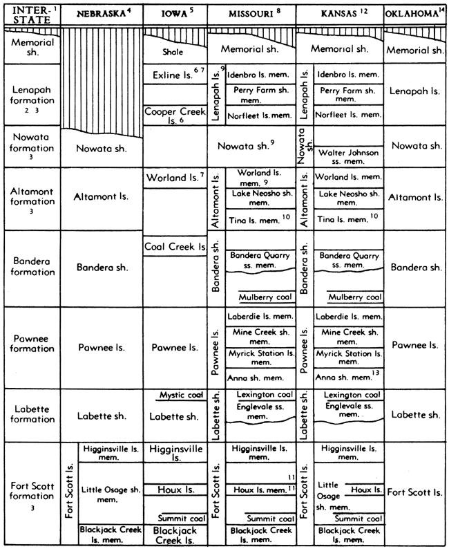
Figure 7. Classification of lower Desmoinesian rocks in the northern midcontinent region. Placement of stratigraphic units in columns (excepting Ardmore and Verdigris limestones, Mulky, Fort Scott, and Bevier coals, Graydon, Bluejacket and Little Cabin sandstones) does not indicate correlation.
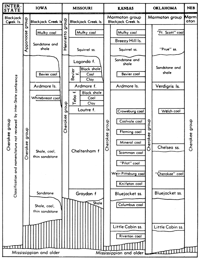
The Desmoinesian rocks of Kansas are divided into two groups, called Cherokee (below) and Marmaton (above). The Cherokee deposits are distinguished in character from Marmaton deposits by relative prominence of sandstone and coal beds and unimportance of limestone; both groups have thick shale formations. The Desmoinesian rocks crop out in southeastern Kansas (Fig. 1). They are the surface beds in most of Cherokee, Labette, Crawford, and Bourbon Counties. The total thickness of rocks belonging to the series in this region is approximately 700 feet.
The Desmoinesian formations are widely distributed in the subsurface of Kansas. They underlie all of the State west of the outcrops of these rocks except over northern parts of the Nemaha granite ridge and locally over the Central Kansas uplift. The deposits of this division are thickest in basin areas like the Forest City and Salina basins; they overlap against buried "highs" of older rocks and where they extend across them, they are generally thin.
Cherokee Group
Definition and Thickness
The Cherokee group is defined to include strata from the base of the Pennsylvanian north of the Kansas-Oklahoma line upward to the base of the Fort Scott limestone (Moore, 1936, p. 55; Haworth & Kirk, 1894, p. 105).
The maximum known thickness of Cherokee rocks north of Oklahoma is in the Forest City basin, in northeastern Kansas and in northwestern Missouri, where this division slightly exceeds 700 feet. The average thickness in southeastern Kansas is about 400 feet. The thickest section in southeastern Kansas is in Labette County where about 500 feet has been measured. On the low structural arch between the Forest City basin and the Cherokee basin the thickness is about 350 feet. Rocks of the Cherokee group overlap older beds on the Ozark uplift giving rise to a much smaller thickness of Cherokee rocks in several Missouri counties (Hinds, 1912, p. 4).
Distribution
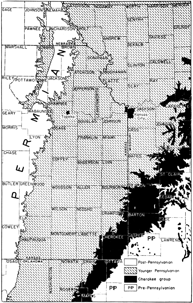
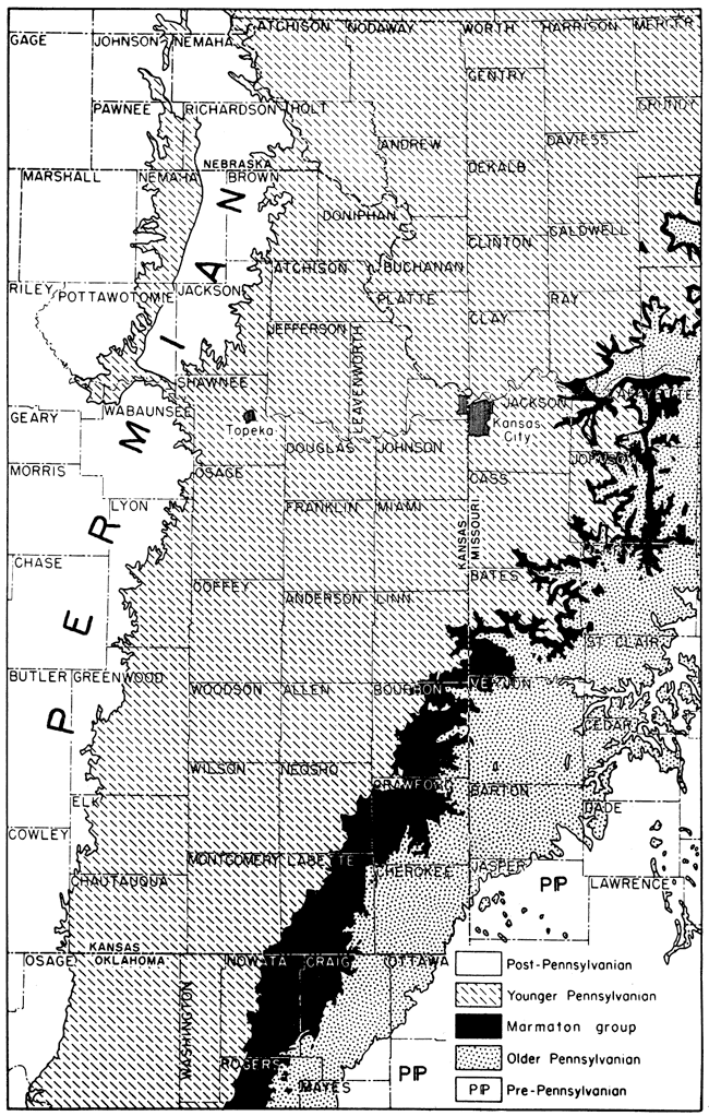
The outcrop belt of Cherokee rocks in Kansas is about 20 miles wide, extending northeast and southwest across the southeast corner of the State (Fig. 8). Its area is about 1,000 square miles, in Cherokee, Crawford, Bourbon, and Labette Counties. Outcrops of Mississippian rocks lie to the south and east and Marmaton strata are exposed on the west and north.
Figure 8. Distribution of Cherokee outcrops in Kansas and parts of adjoining States. The Cherokee group comprises the lower part of the Desmoinesian Series in the Kansas region.
Cherokee rocks are generally absent or are very thin beneath the surface in Kansas west of the Nemaha ridge. Basal Pennsylvanian rocks in the Sedgwick basin in south-central Kansas and a part of the "Sooy" conglomerate in much of western Kansas, however are believed to be equivalent to the upper part of the Cherokee shale of eastern Kansas.
Lithologic Character
Cherokee rocks are chiefly clastic; the amount of limestone is very minor. Shale is strongly predominant, gray clayey and silty micaceous shale being most common, but there is also much sandy shale and sandstone. Very dark or black carbonaceous shale occurs at several horizons. Sandstones in the Cherokee rocks commonly occur in lenticular bodies but the lenses are arranged in definite stratigraphic zones. "Shoestring sands," long narrow channel fillings or bar deposits, are numerous and many of them are important oil and gas reservoirs. Fifteen coal beds have been identified in the Kansas Cherokee section (Fig. 9).
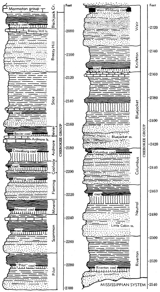
Figure 9. Generalized columnar section of rocks belonging to the Cherokee group, in Kansas. Cyclic divisions are indicated. (Modified from Abernathy.)
The amounts of marine and nonmarine material in Cherokee rocks are about equal. Limestones and other rocks containing marine fossils are rare, whereas fossil land plants are plentiful. All detailed descriptions of Cherokee deposits in southern Iowa, western and northern Missouri, eastern Kansas, and eastern Oklahoma indicate that they were laid down under cyclical conditions.
The Ardmore limestone, 80 to 100 feet below the top of the Cherokee shale, is the most prominent limestone in the Kansas, Missouri, and northeastern Oklahoma section of Cherokee beds (Fig. 7, 9). It has been identified by several geologists with the "Verdigris limestone" of eastern Oklahoma. Abernathy (1937) states that the Ardmore limestone belongs to the second cyclothem below the Fort Scott (Mulky) cyclothem, but in the type locality of the "Verdigris limestone", this unit seems to be separated from the Fort Scott limestone by several cyclical units.
Classification
Cherokee rocks, although containing the most important coal beds and some of the chief oil and gas reservoirs in the State, have not been studied as thoroughly as some of the younger Pennsylvanian strata. Although they are not yet divided into named formations, it is deemed proper to regard Cherokee beds as comprising a group, partly because of similar treatment in neighboring states and partly because continuation of stratigraphic studies promises to allow differentiation into well-defined formational units.
In the east-central Missouri McQueen (1943, pp. 29-93) recognized the following formations in the Cherokee section (in ascending order): (1) Unnamed sandstone and shale, principally cavern and sink fillings; (2) Graydon, basal chert conglomerate and sandstone; (3) Cheltenham, chiefly fire clay; (4) Loutre, limestone and clay; (5) Tebo, coal and shale; (6) Ardmore, limestone and shale; (7) Bevier, coal, clay, and shale; and (8) Lagonda, sandstone and shale. According to McQueen, a pronounced unconformity separates the Cheltenham and Loutre formations and unconformities occur within the Cheltenham. Because of the persistence of coal and limestone beds, the higher formations can be correlated with subdivisions of the Cherokee group in southeastern Kansas. According to Greene & Pond (1926, p. 44) and McQueen (1943, p. 38), the Graydon formation is equivalent to the "Clear Creek" (Bluejacket) sandstone in southwestern Missouri.
Cyclic Sedimentation
Abernathy (1937 p. 19) recognized 15 cyclothems in outcropping Cherokee rocks in Kansas and proposed that each be classed as a formation. In ascending order these are named: (1) Riverton, (2) Neutral, (3) Columbus, (4) Bluejacket, (5) Knifeton, (6) Weir, (7) Pilot, (8) Scammon, (9) Mineral, (10) Fleming, (11) Coalvale, (12) Croweburg, (13) Ardmore, (14) Bevier, and (15) Mulky. The names, except Ardmore (a limestone) and Bluejacket (a sandstone), are the names of coal beds.
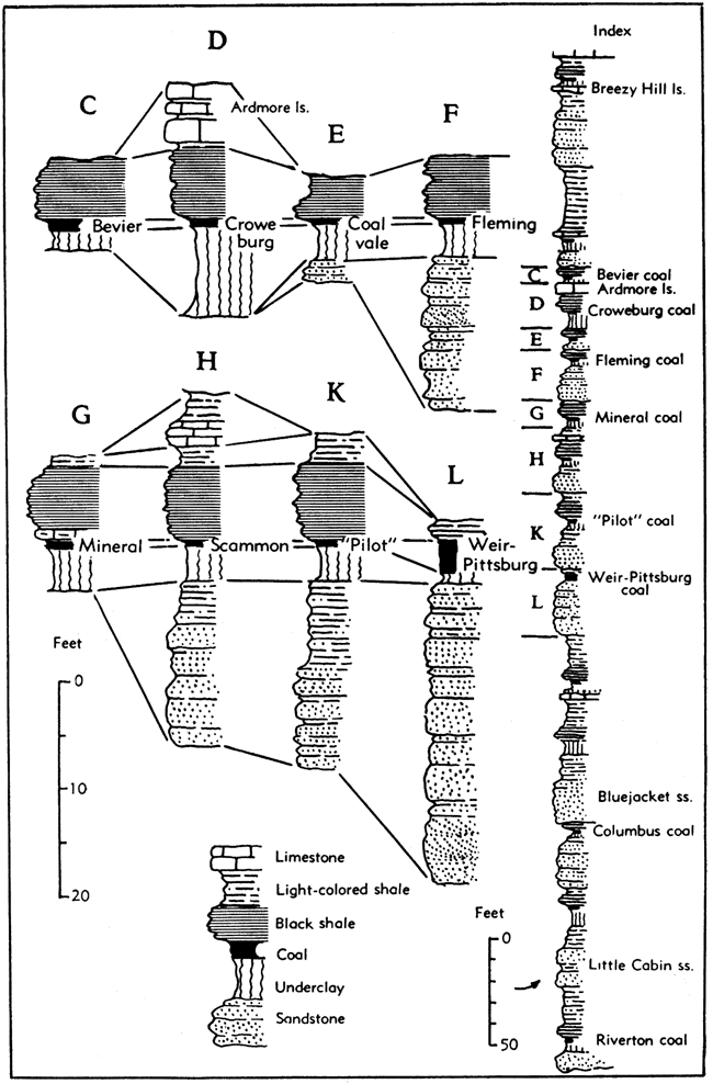
The cyclothems, where fully developed, contain in ascending order the following types of sedimentary deposits: (1) sandstone, (2) sandy shale, (3) underclay, (4) coal, (5) black shale, (6) gray shale, (7) limestone, and (8) calcareous shale. Figure 10 shows the correlation of these similarly arranged deposits in several representative Cherokee cyclothems as observed in southeastern Kansas.
Figure 10. Representative Cherokee cyclothems showing correlation of similar types of sedimentary deposits. The identity of stratigraphic sequence belonging to different cyclothems is indicated even though some of the cyclic units lack certain sorts of rock. The index section at right shows the position of the cyclothems illustrated.
It seems that the Croweburg and Ardmore cyclothems, as designated by Abernathy are really a single cyclothem, and that the Breezy Hill limestone and adjacent calcareous shale beds, occurring a short distance below the Mulky coal, which with sandy deposits were assigned by him to the Mulky cyclothem, constitute a distinct cyclic unit, which may be called the Breezy Hill cyclothem. In Oklahoma, arenaceous beds between the Breezy Hill limestone and the Mulky coal and black shale are interpreted as the lower phases of the cyclothem which includes the Mulky coal.
Also, a definite cyclic succession which includes (in upward order sandstone, light-colored clayey to sandy shale, coal (Stice), black platy shale, limestone, and relatively thick light-colored shale, occurs between the Bevier and Breezy Hill cyclothems (Fig. 9). It is designated as the Stice cyclothem.
Definition of practically useful formational subdivisions of the Cherokee group depends on studies which are not yet completed. Prospectively, the Kansas Geological Survey will adopt a classification based on lithological features of the Cherokee deposits which are judged to be most persistent and to be best suited for objective differentiation of the rock succession. The Survey does not treat the units called cyclothems as formations. Geologists of the Missouri and Kansas Geological Surveys are now at work on the problem of stratigraphic classification of the Cherokee rocks and it is desirable that the recognized formational units in this part of the section shall be defined in identical manner on opposite sides of the State boundary.
Following paragraphs, based primarily on studies by Abernathy (1937), summarize characters of cyclic units which have been recognized in the southeastern Kansas Cherokee section (Fig. 9). They are designated in upward order.
Riverton cyclothem. The lowest Cherokee cyclothem, called Riverton, comprises a basal sandstone followed by underclay and coal (Riverton coal), which lies below black shale and gray shale. The average thickness of the cyclothem is about 38 feet.
Neutral cyclothem. The next higher cyclothem of the Cherokee succession has no observed basal sandstone, but contains the succession: underclay, coal, underclay, coal, black shale, and gray shale. The two coal beds, which are separated by about 3 feet of underclay, are called the Neutral coal.
Columbus cyclothem. The third cyclic assemblage includes the Columbus coal near the top. At the base is about 28 feet of sandstone, followed by about 1 foot each of coal and black shale.
Bluejacket cyclothem. This is the oldest cyclothem of the Cherokee rocks in which marine fossils are reported. It contains a thick basal sandstone (Bluejacket) and shows all phases of fully developed Cherokee cyclothems except coal and calcareous shale. Fossil marine invertebrates occur in about 3 feet of limestone at the top. The thickness of the cyclothem is about 68 feet.
Knifeton cyclothem. Conglomerate in the lower part distinguishes the Knifeton cyclothem. The conglomerate is followed by underclay, coal (Knifeton), black shale, and gray shale. The thickness is about 24 feet. The Knifeton coal is about 8 inches thick.
Weir cyclothem. This consists of sandstone, underclay, coal, and black shale. It is characterized by persistent coal (Weir-Pittsburg) which is one of the most important mined beds in southeastern Kansas. This bed carries a "blackjack" clay parting about 2 feet thick. Abundant fossil plants are found at the coalblack shale contact. The thickness of the cyclothem is about 36 feet.
Pilot cyclothem. The Weir is overlain by the Pilot cyclothem, which contains all the typical phases except two, limestone and calcareous shale. The average thickness is about 35 feet.
Scammon cyclothem. The next higher cyclic sequence, called Scammon, has an average thickness of about 35 feet. In most of its exposures it is fully developed, containing all eight phases. Limestone near the top and black shale overlying the Scammon coal are fossiliferous. Mollusks are fairly abundant.
Mineral cyclothem. This cyclic unit consists of underclay, coal, black shale, and gray shale. The black shale is calcareous and abundantly fossiliferous, especially where thin beds of black limestone occur in the shale. The thickness of the cyclothem is about 12 feet.
Fleming cyclothem. This seemingly unfossiliferous cyclothem contains basal sandstone, sandy shale, underclay, coal (Fleming or Lightning Creek), black shale, and gray shale. The total thickness is about 24 feet.
Coalvale cyclothem. The next unit comprises about 11 feet of beds which contain all the elements of a fully developed Cherokee cyclothem except the upper calcareous parts.
Ardmore cyclothem. Although Abernathy (1937, pp. 19-20) separated the Croweburg coal and underclay below it and black shale above from the Ardmore limestone and underlying shale as separate cyclothems, these beds seem to represent a single cycle. The average thickness of the Ardmore cyclothem is about 22 feet. The Croweburg coal is correlated with the Broken Arrow coal of northeastern Oklahoma and the Ardmore limestone corresponds to the Verdigris limestone of the same area.
Bevier cyclothem. The Bevier cyclothem, about 10 feet thick, contains underclay, coal, and black shale of a typical Cherokee cycle.
Stice cyclothem. Approximately 45 feet of beds occurring next above the Bevier cyclothem in southeastern Kansas are here designated as the Stice cyclothem. These strata underlie the persistent, relatively prominent sandstone called "Squirrel," which is interpreted as part of the Breezy Hill cyclothem.
Breezy Hill cyclothem. The Breezy Hill limestone (Pierce & Courtier, 1938, p. 33) seemingly is the calcareous phase of a cyclothem occurring next above the Stice cycle. Sandstone occurring above the black shale which overlies the Stice coal constitutes the basal clastic phase of the Breezy Hill cyclothem. No coal or underclay is observed between the sandstone and the Breezy Hill limestone. The thickness of strata assigned to this cyclic unit is 50 to 70 feet.
Blackjack Creek cyclothem. Sandy shale, underclay, coal (Mulky bed), black shale, and limestone (Blackjack Creek limestone) belonging in the lower part of the Fort Scott limestone comprise a widely distributed cyclic sequence which may be termed the Blackjack Creek cyclothem. Average thickness of this unit is about 15 feet.
Marmaton Group
Definition and Thickness
Strata from the base of the Fort Scott limestone to the disconformity which marks the upper limit of the Desmoinesian Series are designated as the Marmaton group (Figs. 2, 11). The Marmaton is set apart from the underlying Cherokee group because the former contains prominent limestones. There are four limestone formations and four shale formations which are identified along their outcrop from the Arkansas River Valley in Oklahoma to Iowa and Illinois. Formations that comprise the Marmaton group (in ascending order) are: (1) Fort Scott limestone, (2) Labette shale, (3) Pawnee limestone, (4) Bandera shale, (5) Altamont limestone, (6) Nowata shale, (7) Lenapah limestone, and (8) Memorial shale.
Figure 11. Classification of upper Desmoinesian rocks in the northern midcontinent area adopted by interstate conference of geological surveys. The agreed classification, shown in the column at left margin, is compared with classification previously used in the several states.
1. Classification and nomenclature of subdivisions of formations not reviewed by interstate conference.
2. Not recognized in Nebraska.
3. Not recognized in Iowa.
4. Condra and Reed (1943).
5. Cline and Stookey (unpublished chart); Cline (1941).
6. Correlation with Lenapah limestone not established.
7. Recognized by Cline (1941) in northern Missouri, also; placed in Pleasanton by Clair (1943).
8. Mainly based on unpublished chart by W. V. Searight (1948).
9. McQueen and Greene (1938) report that Nowata and Lenapah beds are absent in Missouri and class Worland as subdivision of Bandera shale.
10. Type Tina limestone is now known not to belong in Altamont; new name is to be substituted.
11. Clair (1943).
12. Moore, Frye, and Jewett (1944).
13. Includes thin limestone at base.
14. Newell (1937); Oakes and Jewett (1943).
The combined average thickness of these formations in Kansas is about 250 feet. The type locality of the Marmaton group is along Marmaton River, from Uniontown to Fort Scott, Bourbon County, Kansas.
The Marmaton group has been defined in the sense here indicated during many years in Kansas, northeastern Oklahoma, and Nebraska, being employed extensively in subsurface nomenclature as well as in classification of outcropping beds (Fig. 11). The term Henrietta group, which was formerly applied to beds from the base of the Fort Scott limestone to the top of the Pawnee limestone, has been used previously in Missouri (McQueen & Greene, 1938; Grohskopf, Hinchey, & Greene, 1939; Clair, 1943) and Iowa (Cline, 1941) as an exact synonym of Marmaton, but Cline (1939) and McQueen (1943, p. 90) altered the stratigraphic span of Henrietta by including in it upper beds of the Cherokee as previously classified (Fig. 7). This name is now abandoned both because in common later usage it duplicates Marmaton and because formations overlying the Pawnee limestone are not well developed near Henrietta. The name Appanoose, which was introduced by Bain (1896) for deposits in Iowa that approximate the span of the Marmaton group (Fig. 7), was used by Cline (column 31 of chart in Moore et al., 1944) for upper Desmoinesian beds, classed as a group, extending downward to a somewhat prominent disconformity that is recognized in Iowa between the Ardmore and Blackjack Creek limestones. Thus, the Appanoose includes some upper Cherokee strata and corresponds to Henrietta group as treated by Cline in 1939 (p. 1905) and as redefined by McQueen (1943). The Iowa and Missouri geological surveys have joined Kansas, Nebraska, and Oklahoma in recognizing Marmaton group.
Distribution
Marmaton rocks crop out in Kansas in a belt ranging in width from about 10 miles to 25 miles (Fig. 12). The outcrop belt extends from Linn and Bourbon counties on the Kansas-Missouri boundary to Montgomery and Labette counties on the Kansas-Oklahoma boundary. The general strike is about 30° east of north and the dip, which is westerly, averages about 20 feet to the mile. The prevalent dip locally is interrupted by minor flexures.
Figure 12. Distribution of Marmaton outcrops in Kansas and parts of adjoining states. The Marmaton group comprises the upper part of the Desmoinesian Series of Pennsylvanian rocks in the northern midcontinent region.
Lithologic Character
The Marmaton group comprises the upper and more calcareous part of the stratigraphic section assigned to the Desmoinesian Series. In Kansas the Marmaton rocks are dominantly shale, limestone being second in quantitative importance, and sandstone third. There is a minor amount of coal.
Desmoinesian limestones differ in lithologic characteristics from those of younger parts of the Pennsylvanian section. The most noticeable difference is the absence of certain lithologies, such as flinty limestone, which is plentiful in the Kansas City group, that are common in higher beds. Marmaton limestones are only locally and very sparsely flint bearing. Massive cross-bedded oölitic limestone, which is mostly a mass of algal pellets, is characteristic of the Kansas City group, but is absent from Marmaton rocks. Fusulines, although present in several Desmoinesian limestones, are not important rock makers in this part of the section. Most of the limestone in these rocks is light gray and weathers into a rock of even lighter color. This contrasts with most of the limestone of younger groups, which develops a rusty brown coating when exposed for a few years. Brown-weathering limestone beds are not absent from the Marmaton group, however. One type of finely crystalline brownish-gray limestone characteristically weathers into a dark-brown-coated rock. The most common limestone type in the Marmaton group is a light-gray, rather coarsely crystalline rock, which has the appearance of being a breccia. Small limestone fragments of irregular outline are imbedded in a matrix of slightly different color and texture. Coralline limestone, which is dominantly composed of Chaetetes colonies, is a distinctive rock in the Marmaton group.
The thicker shale units include sandstones which consist of channel fills in clay shale and sheet-like bodies that grade laterally into sandy shale. In general, the sandstone channel fills are not more than 25 feet in greatest thickness.
Shale members of the limestone formations are partly, if not wholly, marine. They contain brachiopods, bryozoans, crinoid remains, and locally, mollusks and corals. Black carbonaceous shale and small amounts of coal are characteristic of some of the thinner shale units. Where fossiliferous, the black shales contain a sparse fauna in which thin-shelled brachiopods are the most conspicuous element; conodonts are present locally. Small dark phosphatic concretions are common in the black shales. The thin fossiliferous shales are more finely bedded than the thicker nonmarine shales.
Coal beds are mostly thin and discontinuous, but a few beds are persistent and locally attain minable thickness.
Cyclic Sedimentation
The Marmaton group is composed of alternate nonmarine and marine deposits which clearly reflect successive oscillations of the strand line in eastern Kansas during late Desmoinesian time. Repetition of rock sequences, in which the types of lithological and paleontological characters characterizing various strata are arranged in constant order, is seen, both in the nonmarine and marine sedimentary accumulations and although some kinds of deposits found in the most complete sequences are missing here and there, the regularity of the repeated stratigraphic pattern demonstrates the cyclic nature of Marmaton sedimentation (Fig. 13). As in the Cherokee group, there are beds of the following types, one overlying another in upward order: (1) nonmarine sandstone, commonly uneven at the base, occupying channels cut in subjacent rocks, (2) sandy, silty, and clayey shale, unfossiliferous or containing land plant remains, (3) underclay, (4) coal, (5) black platy shale containing conodonts, and commonly bearing small spheroidal phosphatic concretions, (6) gray to brownish clayey or calcareous shale, or limestone containing a varied assemblage of marine invertebrates. Such a rock sequence represents a simple sort of progression from nonmarine to marine deposition associated with advance of a shallow sea. Retreat of the sea followed by re-advance is indicated by stratigraphically higher layers having similar arrangement.
Figure 13. Generalized columnar section of rocks belonging to the Marmaton group in Kansas. This group is mainly distinguished from adjoining groups by prominence of limestones.
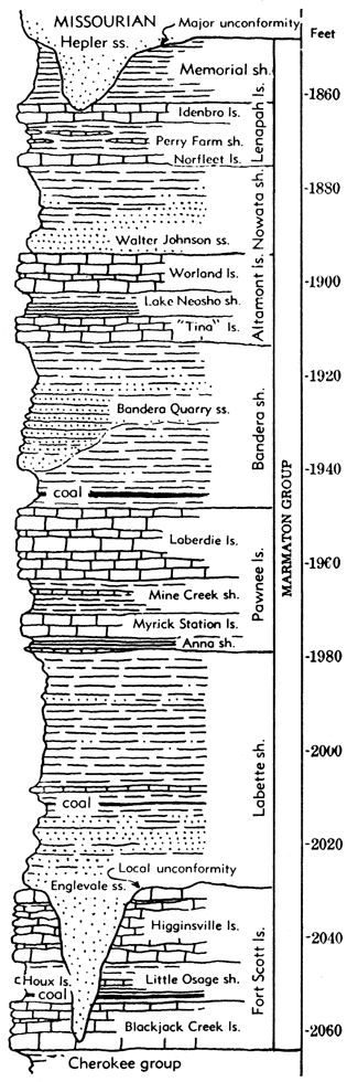
The Marmaton group also offers evidence of a more complex arrangement of repeated sequences of rock layers in which cyclic deposits of somewhat differing sorts are disposed one above another in regular order. Such a cycle of cycles has been termed a megacyclothem (Moore, 1936, p. 29). Seemingly, it represents an oscillatory transgressive movement of the seas on which Pennsylvanian marine deposits of the Kansas region were laid down. Minor retreats of the strand line separated advances of the sea margin and at any one locality this is recorded by the shifting nature of limestone, shale, sandstone, and carbonaceous materials (including coal) which accumulated.
Each of the four limestone formations of the Marmaton group, combined with adjacent parts of the relatively thick intervening shale formations, is composed of three or four individual cyclothems representing distinct, though in many places incompletely expressed, marine invasions and retreats. Thus, four megacyclic groupings of the Marmaton strata may be recognized. In these, the limestone formations comprise records of dominant marine conditions whereas the shale formations furnish records of dominant nonmarine conditions. Minor, and somewhat local, marine invasions are recorded in cyclothems included in the shale formations, and minor, somewhat local emergent, or near-emergent conditions are recorded by shale members of the limestone formations.
Classification
The Marmaton rocks contain some persistent formational units which are recognized in Kansas, Oklahoma, Missouri, Iowa, and Nebraska. Classification has differed, however, in a few features in the different states (Fig. 11) and it continues to lack complete uniformity. The divergence is largely a reflection of stratigraphic differences. For example, the assemblage of limestones and shales from Blackjack Creek to Higginsville limestones, inclusive, which comprises the unit called Fort Scott formation in Kansas, is judged to be unnatural in Iowa; accordingly, Fort Scott is not recognized and the rock divisions which are classed as members of the Fort Scott in Missouri and Kansas are treated in Iowa as independent formational units. The Coal Creek limestone, which is found in northern Missouri and Iowa, has not been identified in western Missouri, Kansas, and northeastern Oklahoma. Relations of the Cooper Creek and Exline limestones to the Lenapah formation are undetermined. Marmaton strata are buried in Nebraska.
Fort Scott Limestone
The lowermost formation of the Marmaton group is known as the Fort Scott limestone (Swallow, 1866; Bennett, 1896) (Fig. 13). The formation is composed of two main limestone units and an intervening shale which contains thin, persistent limestone beds and a coal (Fig. 11). The lower limestone, commonly known as the "Cement rock," now is called the Blackjack Creek limestone member and the upper limestone, sometimes termed "Lexington bottom rock," is the Higginsville limestone member. The intervening beds are designated as the Little Osage shale member. It contains the Houx limestone and Summit coal.
The Fort Scott has been identified along its outcrop line from Arkansas River Valley in Oklahoma to southern Iowa, but in Iowa, the individual limestone and shale components are classed as formations. Equivalent beds are recognized in Illinois (Weller & others, 1942, p. 1586, fig. 1).
Blackjack Creek limestone member. The lower Fort Scott or Blackjack Creek limestone (Cline, 1941, p. 36) rests on black shale which is classed as the uppermost part of the Cherokee group. At the outcrops in Kansas, this limestone ranges in thickness from about 4 feet to 17.5 feet,
The lower part of the member is sparsely fossiliferous limestone called "Cement rock." It weathers brown but in fresh exposure, appears tan, brownish, or dark dove gray. The rock is mostly somewhat earthy and dense but locally it has a fine crystalline texture. Conchoidal fracture is common. The "Cement rock," which ranges in thickness from 1.5 to 10 feet, has thicker and more regular bedding than the upper part of the Blackjack Creek limestone.
The upper part of the Blackjack Creek limestone is easily distinguished from the "Cement rock" by its lighter gray color, more coarsely crystalline texture, and thinner, more irregular bedding. Locally it is separated from the "Cement rock" by a thin shale parting. The upper unit disappears north of Bourbon County, Kansas, for at outcrops in northern Bourbon and Linn counties and in eastern Missouri, the Little Osage shale rests directly on the "Cement rock." Similar conditions prevail locally in northeastern Oklahoma. The upper part of the Blackjack Creek limestone ranges from a featheredge to 13 feet in thickness.
Except for the rock-building coral, Chaetetes, which is mostly confined to the upper part, fossils are rather scarce in the Blackjack Creek limestone. Fusulines occur more commonly in the upper part. Mollusks are plentiful in the "Cement rock" portion of this member in Oklahoma.
Little Osage shale member. The middle member of the Fort Scott formation, called Little Osage shale (Jewett, 1941, p. 306), is persistent. In its lower part is the Summit coal, named from Macon County, Missouri (McGee, 1888, p. 331), and in the middle part is the thin but very persistent Houx limestone (Cline, 1941). The thickness of the Little Osage shale at its outcrops in Kansas ranges from 4 to 12 feet, but it becomes thicker northeastward in Missouri.
The light to dark-gray, locally calcareous shale beneath the Summit coal is about 3 feet thick in Kansas. Maximum thickness of the Summit coal is about 1 foot. The shale overlying the Summit bed is black and fissile, or gray in the lower part and black in the upper part. The black shale attains a thickness of 10 feet and commonly contains spheroidal phosphatic concretions. The Houx limestone bed is about 1 foot thick in western and northern Missouri but only a few inches in Kansas. The uppermost part of the Little Osage shale consists of gray calcareous shale, 1 to 4.5 feet thick, the greatest known thickness being in Missouri. The Summit coal and Houx limestone beds extend southward to Fort Scott, in Bourbon County, Kansas, and possibly farther. Locally in southeastern Kansas and northeastern Oklahoma, the Little Osage shale consists almost entirely of black fissile shale. Fossils are rather scarce in this member but horn corals occur in the upper few inches at some outcrops in western Missouri and conodonts are rather abundant in the black shale.
Higginsville limestone member. The upper member of the Fort Scott limestone, called the Higginsville limestone (Cline, 1941, p. 36), is 12 to 15 feet thick along most of its outcrop belt in Kansas (Fig. 13). The limestone is a light to dark gray rock which commonly has a medium-grained crystalline texture and displays a brecciated appearance. The lower part is thicker bedded than other parts generally, but the whole unit displays irregular wavy beds, which are thinnest in the middle of the member. At many places, the upper beds are largely made up of the coral Chaetetes. Large fusulines and large crinoid stems also are common.
Labette Shale
The Labette shale (Haworth, 1898) includes beds, mostly shale and sandstone, occurring between the Fort Scott and Pawnee limestones (Figs. 11, 13).
Average thickness of this formation along the outcrop in Kansas is about 40 feet but changes in thickness are rather abrupt, the range being from about 30 to 100 feet. In general, thickness increases southward.
The Labette includes clayey and silty shale, sandstone, and minor amounts of limestone and coal. A persistent limestone occurs in the upper-middle part in southeastern Kansas and in northeastern Oklahoma. Coal beds, which are rather local, seem to represent parts of different cyclothems. A black shale and coal zone occurs in the upper part of the Labette next below the persistent thin limestone that marks the base of the Pawnee limestone.
Sandstone lenses, consisting partly of channel fillings, are common in the Labette shale, but they are less numerous in Kansas than in Missouri and Oklahoma. A channel sandstone in the lower part of the formation, which is locally prominent in southeastern Kansas, is named the Englevalle sandstone (Pierce & Courtier, 1935, p. 1061). Locally, the sandstone extends downward into depressions eroded in the Fort Scott limestone (Fig. 13). Sandstone bodies which are encountered in subsurface parts of the Labette shale are generally designated as "Peru sand"; some of these bodies are sources of oil and gas production.
Thin limestone beds and calcareous shale belonging to the Labette formation contain brachiopods and other marine fossils. Most beds are poorly fossiliferous or barren of fossils, however.
Pawnee Limestone
The Pawnee limestone (Swallow, 1866; Moore, 1936), which lies between the Labette and Bandera shales, is the first prominent limestone assemblage above the Fort Scott formation. In Kansas the following members (in ascending order) are recognized: (1) Anna shale, (2) Myrick Station limestone, (3) Mine Creek shale, and (4) Laberdie limestone (Figs. 11, 13). The inclusion of a shale member at the base of a limestone formation is explained by the presence of a thin slabby, somewhat lenticular limestone at the base of this shale throughout a wide area. This limestone thickens northeastward in Missouri and southward in Oklahoma, where it comprises a major part of the Oologah limestone (Jewett, 1941, p. 290). Logically, the limestone and the overlying shale, which are mostly shale in Kansas, belong in the Pawnee limestone assemblage. Moore (1936, p. 62) has amended definition of the Pawnee limestone to include these beds.
In Oklahoma, beds equivalent to the Pawnee limestone compose the main part of the Oologah limestone, which crops out a few miles east of Tulsa. It has been traced across Missouri into Iowa (Cline, 1941 p. 37; Jewett, 1941, p. 312) and its equivalent is recognized in Illinois (Weller & Others, 1942, pp. 1591-1592). A graphic section of the Pawnee limestone and adjacent rocks in Kansas is given in Figure 8.
Anna shale member. The Anna shale member, at the base of the Pawnee formation, lies below the Myrick Station limestone member. It includes the Lexington coal of Missouri. At outcrops in Kansas, the Anna shale ranges in thickness from 2 feet to 13 feet and consists chiefly of black fissile shale. The upper few inches consists of gray shale. Commonly it contains small, black, nearly spherical phosphatic concretions imbedded in the black shale. A thin bed of slabby black crystalline or earthy limestone occurs below the black shale. The black limestone is widely distributed in Missouri where it has been identified just below the Lexington coal. In Crawford County, Kansas, the upper middle part of the Anna shale is very coaly. The Anna shale contains fragments of crinoids and other fossils in the basal limestone and flattened brachiopod shells in the black shale.
Myrick Station limestone member. The Myrick Station limestone (Cline, 1941, p. 37) is the so-called "Lexington cap-rock" near Lexington, Missouri, and at its type locality near Myrick Station, Missouri. This limestone is easily identified in numerous outcrops in Missouri and Kansas. Its thickness ranges from less than 1 foot to approximately 8.5 feet. Where the member is thickest, the limestone is found to be composed largely of colonies of Chaetetes, which occur mostly in the upper part. The lower part of the limestone is characteristically a dark brownish-gray or dove-gray, massive, regularly bedded rock which weathers tan or brown. This division has a fairly uniform thickness of 3 to 4 feet. Chaetetes colonies, crinoid fragments, brachiopods (especially Squamularia), and fusulines are common fossils in the Myrick Station limestone.
Mine Creek shale member. North of Marmaton River in Kansas and in Missouri, the Pawnee limestone includes a well-defined shale unit next above the Myrick Station member. This is called the Mine Creek shale member (Jewett, 1941, p. 318). South of Marmaton River, the shale is thin but can be identified in many exposures. The thickness of the Mine Creek member ranges from a featheredge to about 17 feet, the thickest sections occurring in the northern part of the outcrop belt. In northeastern Oklahoma, the thickness is commonly less than 1 foot.
The Mine Creek shale consists of gray, black, greenish-gray and yellow shale and a little limestone. In Linn and Bourbon counties, Kansas, the Mine Creek is divisible into three parts: a lower yellowish to greenish-gray limonitic shale, a thin limestone in the middle, and an upper calcareous shale which contains an extensive fossil zone. Locally this becomes a coquina of brachiopods. Chonetids are the most plentiful fossils. In southern Kansas the Mine Creek shale is identified as a thin parting between the Myrick Station and Laberdie limestones, which are distinguishable by lithologic differences.
Laberdie limestone member. The uppermost member of the Pawnee formation is the Laberdie limestone (Jewett, 1941, p. 320). It is approximately 10 feet thick in the northern part of the outcrop area in Kansas and 20 feet on the average in the southern part. The limestone is light gray, crystalline, and brecciated. It occurs in rather thin wavy beds or beds of irregular thickness, although the lower part is somewhat more massive. Locally, Chaetetes is plentiful, especially in the upper part. Fossils commonly are silicified, but chert nodules are rare.
The upper part of the Laberdie limestone weathers into a "cotton rock" having an irregular hummocky surface, which is pitted and flecked with brown. Sparse fusulines, crinoid and echinoid fragments, and brachiopods, in addition to abundant Chaetetes, are characteristic fossils and in Oklahoma silicified specimens of Cystauletes mammilosus King, a cylindrical sponge, are locally abundant.
Bandera Shale
The Bandera shale (Adams, in Adams, Girty, & White, 1903, p. 32) comprises relatively thick shale and sandstone occurring above the Pawnee limestone and below the Altamont limestone (Figs. 11, 13). A rather persistent flaggy sandstone member called Bandera Quarry sandstone (Jewett, 1941, p. 292) appears in the upper part (Fig. 8). Near the base, the Mulberry coal (Hinds, 1912, p. 75), which is more than 2 feet thick in many places, is traced from southern Bourbon County, Kansas, far northward into Missouri. It is mined extensively. The thickness of the Bandera shale ranges from about 35 to 75 feet at the outcrop in Kansas. Well records in eastern Kansas show 45 to 100 feet of Bandera shale.
Shale of the Bandera formation is mostly light in color, but a very persistent maroon shale occurs in the upper part. The shale beneath the Mulberry coal is clayey and carbonaceous.
Sandy deposits of the Bandera shale include channel fillings and evenly layered sandstone sheets. Locally in Missouri some channel sandstone cuts out upper beds of the Pawnee limestone. The Bandera Quarry sandstone member comprises fine-grained micaceous flagstones which attain a thickness of 30 feet or more. Bedding planes are marked commonly by abundant trails and castings, probably made by marine worms.
A thin bed of nearly black limestone occurs in Bourbon County, Kansas, in the lower part of the Bandera shale just above the Mulberry coal. A limestone is noted at the same horizon in wells farther north in Kansas and in western Missouri.
The Bandera shale contains few invertebrate fossils, but fragments of land plants are abundant, especially in the lower part of the formation just above the Mulberry coal.
Altamont Limestone
The Altamont limestone (Adams, 1896) lies next above the Bandera shale. It comprises limestone and shale beds which are best developed in southeastern Neosho and Labette counties, Kansas, and Bates County, Missouri (Fig. 11, 13). The formation is identified from northeastern Oklahoma to southern Iowa (Cline, 1941, pp. 26-27; Jewett, 1941, p. 326) and is recognized in the subsurface of much of eastern Kansas. Subdivisions of the formation are designated (in upward order) as "Tina" limestone member, Lake Neosho shale member, and Worland limestone member. The type section of the Tina limestone (Cline, 1941, p. 43), has recently been found to belong well below the Altamont and consequently, until a new name for the lower Altamont is chosen, this limestone is called "Tina".
"Tina" limestone member. The lowest member of the Altamont limestone ranges in thickness from a featheredge to slightly more than 10 feet. Like several other Marmaton limestones, it is largely made up of Chaetetes colonies at many places. The member generally is thicker in the south than in the north. At several places it contains three limestones separated by thin shale beds. The uppermost limestone, which is a gray crinoidal bed, is the most persistent part of the member.
Lake Neosho shale member. The middle member of the Altamont limestone, called Lake Neosho shale, is a widely distributed, distinctive unit, which can be identified in exposures where the underlying limestone member is absent. The characteristic thickness of the shale is about 2 feet, but locally it is nearly 6 feet. The shale is yellowish gray and black, the latter occurring uniformly in the lower or middle part. A characteristic feature of the black shale is the presence of irregularly shaped, slightly elongated, dark phosphatic nodules. Commonly they contain fish teeth and bone fragments.
Worland limestone member. The upper member of the Altamont limestone, called Worland (Cline, 1941, p. 29; Jewett, 1941, p. 334), is known from Oklahoma to Iowa. This limestone has a rather uniform thickness of about 8 feet in Kansas, but generally it is somewhat thinner in the northern part of its outcrop area. It is a light bluish-gray, massive, fine-grained rock; in some places the lower part is brecciated. Chemically, the Worland limestone is purer than other Marmaton rocks, many samples being found to contain approximately 97 percent CaCO3. Fossils of the member include chonetids, Squamularia, Composita, other brachiopods, and fusulines.
Nowata Shale
Shale and sandstone between the Altamont and the Lenapah limestones are called Nowata shale (Ohern, 1910, p. 23) (Figs. 11, 13). Along its outcrop in Kansas, the thickness of this formation ranges from almost nothing to approximately 50 feet and locally changes in thickness are abrupt. The Nowata includes light and dark gray to yellow, limonitic clay shale, sandy shale, and sandstone; no coal beds have been found in this part of the section in Kansas. Black shale at the top of the formation commonly contains small smooth dark phosphatic concretions. At most places the Nowata shale is sandy and commonly contains massive, abundantly micaceous sandstone bodies. Lenses of sandstone ranging in thickness to 10 feet or more are locally prominent in the lower Nowata of southern Kansas. Such deposits are differentiated as the Walter Johnson sandstone (Jewett, 1941, p. 335) (Fig. 13). Generally the Nowata shale is unfossiliferous, but brachiopods, including Mesolobus, are common in places in the dark shale.
Lenapah Limestone
The Lenapah limestone (Ohern, 1910) which overlies the Nowata shale, is named from the town of Lenapah in Nowata County, Oklahoma. It is divisible into members named (in upward order) Norfleet limestone, Perry Farm shale, and Idenbro limestone (Fig. 11, 13). In Iowa, the Cooper Creek limestone, Exline limestone, and intervening shale are correlated with Lenapah beds.
Norfleet limestone member. The lower part of the Lenapah limestone, below nodular, locally fossiliferous shale in the middle part, is called the Norfleet limestone member (Jewett, 1941, p. 338). This lower member is absent or very poorly developed along much of the outcrop in southeastern Kansas, but it can be identified readily at various places from northeastern Oklahoma northeastward to Bates County, Missouri, and it may be represented in Iowa by the Cooper Creek limestone. In southern Kansas, the Norfleet limestone has a maximum known thickness of 3 feet, but near Lenapah, in northeastern Oklahoma, it is 14 feet thick. Throughout most of the northern part of the Kansas outcrop area, this limestone is about 0.5 foot thick. Where best developed, as in northeastern Oklahoma, the limestone is a light-gray, sandy, hard massive rock which contains few fossils. In Labette County, Kansas, it varies from massive limestone bearing abundant productid brachiopods (Dictyoclostus) to slabby limestone which is partly crinoidal, partly characterized by numerous land plant remains. Farther north, is consists of interbedded dark-gray sandy limestone and calcareous shale. The Norfleet limestone is seemingly absent from nearly all the outcrop belt in Bourbon County, but it occurs locally there and in Linn County.
Perry Farm shale member. The middle member of the Lenapah formation includes calcareous fossiliferous shale above the Norfleet limestone and below the Idenbro limestone (Jewett, 1941, p. 339). It is characterized by irregular limestone nodules in gray shale. At its upper boundary the Perry Farm shale grades into the overlying Idenbro limestone. The thickness of this member in Kansas ranges from a featheredge to about 20 feet. Nodules and discontinuous lenses of gray dense limestone which occur in the Perry Farm shale member commonly range in thickness from a fraction of an inch to 6 inches, but just south of the Kansas-Oklahoma boundary, nodular, mottled limestone belonging to this member attains a thickness of 2 or 3 feet. Locally in Bourbon County, Kansas, and in western Missouri, the Perry Farm shale includes black shale.
At some places the Perry Farm shale contains abundant fossils including corals, mollusks, and brachiopods, especially Marginifera.
Idenbro limestone member. The upper, most prominent member of the Lenapah limestone, called the Idenbro limestone (Jewett, 1941), forms a low escarpment in Labette and Montgomery counties, Kansas. Thickness of this limestone ranges from 1 to 7 feet in Kansas, the greater thickness prevailing toward the south. The member is thin and inconspicuous north of Labette County.
The Idenbro limestone is generally a light-gray nodular rock. Analysis of typical samples indicates a silica content of 35 percent. The lower part of the member generally is massive and the upper part thin-bedded. In northern outcrops the rock is more sandy, darker in color, and generally more limonitic than in the south. Although it is a thin ledge in Linn and Bourbon counties, Kansas, the rock is massive, showing no tendency to weather into thin slabs as it does elsewhere.
Algal remains, corals, and bryozoans are common in the Idenbro limestone. Among the corals are Aulopora and horn corals; Chaetetes has not been observed. Brachiopods, including Mesolobus, are common. Fragments of crinoids and bryozoans, such as Prismopora and Fistulipora, stand out in relief on weathered slabs of the rock.
Memorial Shale
The Memorial shale (Dott, 1936, 1941) includes all observed Desmoinesian beds in the northern midcontinent region above the Lenapah limestone (Figs. 11, 13). In Kansas and western Missouri, it embraces shale between the Idenbro limestone and the Hepler sandstone (Jewett, 1941, p. 340), which lies next above the post-Desmoinesian disconformity. The Memorial beds are generally present above the Lenapah limestone in Kansas, except locally where they have been removed by pre-Missourian erosion. The shale is absent in northeastern Oklahoma (Oakes & Jewett, 1943, p. 633), in an area extending 20 miles or more southward from the Kansas-Oklahoma boundary. In parts of Linn County, basal Missourian sandstone rests directly on the eroded surface of the Lenapah limestone or lower beds. The Memorial shale in Kansas ranges from a featheredge to about 30 feet in thickness.
In most outcrops the Memorial consists of well-bedded, slightly blocky gray clay shale. Some red shale is present locally in the lower part. Small lenses of limonite are common. In a few places the shale is slightly sandy. A coal bed underlain by black shale occurs near the base of the Memorial shale in southern Kansas.
The Memorial shale is barren of fossils along most of its outcrop area, in Kansas, but corals and brachiopods are common near Mound Valley in Labette County. There the corals Striatopora austini and Aulopora occur very abundantly. The brachiopod Mesolobus ranges upward nearly to the base of the Hepler sandstone.
Prev Page--Lower Pennsylvanian || Next Page--Upper Pennsylvanian
Kansas Geological Survey, Geology
Placed on web Jan. 26, 2009; originally published Nov. 1949.
Comments to webadmin@kgs.ku.edu
The URL for this page is http://www.kgs.ku.edu/Publications/Bulletins/83/06_mid.html