![]()
Prev Page--Middle Pennsylvanian || Next Page--Upper Pennsylvanian, Virgilian Series
Upper Pennsylvanian Rocks
General Description
Upper Pennsylvanian rocks of the northern midcontinent region have become widely known as the Missourian and Virgilian Series. The deposits of these divisions were classed together by Moore & Thompson (1949) as the Kawvian Series. Many characters which belong in common to Missourian and Virgilian formations, especially their lack of strongly marked paleontological differentiation, served to link them. Together they form the Zone of Triticites and they are readily distinguished on the basis of their fusulinid content from underlying Middle Pennsylvanian rocks belonging to the Zones of Profusulinella, Fusulinella, and Fusulina (Fig. 5).
The Upper Pennsylvanian rocks of Kansas, here treated as containing the Missourian and Virgilian Series, are bounded below by the disconformity and prominent paleontological break which separates Desmoinesian from Missourian deposits. Their upper boundary is defined by the disconformity or angular unconformity which marks the line between Pennsylvanian and Permian rocks throughout most of North America. The Kansas region contains a well-exposed, nearly complete section of these Upper Pennsylvanian formations, both marine and continental, in which are found innumerable richly fossiliferous zones. The Missourian and Virgilian deposits are remarkably displayed in the regular succession of evenly dipping strata in this area. The many hard rock units form east-facing escarpments one after another in roughly even spacing until that formed by the Brownville limestone at the top of the Pennsylvanian is reached, beyond which are other escarpments formed by the Permian limestones. The weak rocks make plains between the escarpments.
Upper Pennsylvanian rocks show less disparity of development in the geosynclinal belt and stable platform region farther north, as represented by the thickness of deposits found in southern Oklahoma and spread over northern Oklahoma, Kansas, Missouri, Iowa, and Nebraska. This is true even though Missourian deposits are represented by several thousand feet of strata in the Ardmore basin area.
Upper Pennsylvanian rocks exhibit somewhat more marked facies variation than the older part of the system. In eastern Kansas and neighboring territory of the northern midcontinent, in north-central Texas, and parts of New Mexico, the Missourian and Virgilian deposits are characterized by dominance of marine strata and prominence of limestones. The Oklahoma region and part of Texas near the Red River Valley, on the other hand, contain Upper Pennsylvanian rocks among which nonmarine clastics, including prominent red sandstone and shale, predominate. Marine deposits are relatively unimportant and limestones are almost lacking. Similar to the Oklahoma Upper Pennsylvanian in the prevailing nonmarine character of sedimentation, but differing in unimportance of redbeds and presence of numerous coal beds, are formations of the Conemaugh and Monongahela groups in the Appalachian region; here fresh-water limestones are common.
The stratigraphic relationship of the Missourian Series to underlying rocks has been discussed. The upper limit of the Pennsylvanian System has been drawn at more than a half-dozen different horizons during the last twenty-five years (Moore, 1940) (Fig. 4). Agreement is now general among American geologists that the Pennsylvanian-Permian boundary belongs at the base of the Zone of Pseudoschwagerina (Wolfcampian, Sakmarian) and equivalent Zone of Callipteris (Autunian, lower Rotliegende), and this view has concurrence of various Europeans. Consequently, the upper Virgilian boundary is placed at a widespread disconformity near the Brownville limestone of Kansas and at the base of the Pueblo formation as now defined in north-central Texas. In western Texas there is an angular unconformity between Upper Pennsylvanian deposits of the Gaptank formation and Wolfcampian rocks classed as Lower Permian. This unconformity is evidently associated with mountain-building disturbances which occurred in the Marathon region of western Texas at or near the close of Virgilian time. Wolfcampian rocks overlie the beveled edges of the entire Pennsylvanian section and overlap onto the Pre-Cambrian in extreme western Texas and southern New Mexico.
The upper part of the Gaptank formation in the Glass Mountains of Texas, which is in contact with Lower Permian, is of middle Virgilian age. Therefore, the upper part of the Virgilian is missing in this area. An unconformity of similar magnitude is recognized at Abo Canyon and in the northern Oscura Mountains of New Mexico. In the southern Oscura Mountains, however, the stratigraphic break at the top of Virgilian deposits seems to have much smaller magnitude. The break at the top of the Virgilian Series in Kansas does not seem to have had long duration.
Most Upper Pennsylvanian faunas are distinctive assemblages when compared with the fossils known from adjacent older and younger strata. Although the upper Paleozoic ammonoids are distributed in more or less gradational sequence (Miller & Furnish, 1940), the ammonoid zones of Prouddenites and Uddenites characterize Missourian and Virgilian strata in various parts of North America. The Canyon formation (Missourian) of Texas locally contains abundant ammonoids, including Prouddenites and Cisco (Virgilian) rocks also yield numerous ammonoids, including Uddenites. Brachiopods are abundant throughout the Upper Pennsylvanian succession but they have not been studied in sufficient detail to permit satisfactory use of them for paleontological zonation.
Fusulinids are abundant throughout the Missourian and Virgilian section above the Bethany Falls limestone or equivalent horizons. These fusulinids, particularly species of Triticites, seem to be among the most reliable fossils for local, as well as interregional, correlations of different parts of the two series. Most fusulinids in the Upper Pennsylvanian are referable to Triticites, and together, the Missourian and Virgilian rocks comprise the Zone of Triticites (Fig. 5). Other fusulinid genera represented in these rocks include Dunbarinella, Schubertella, Waeringella, and Millerella. Although forms of Triticites are present in the overlying Wolfcampian rocks, the faunas of the Wolfcampian are dominated by species belonging to more advanced fusulinid genera (Moore & Thompson, 1949).
The early Missourian forms of Triticites have highly elongate shells similar to and including T. irregularis (Staff). These forms are surely not primitive representatives of the genus and this suggests incompleteness in the record of evolving fusulinid forms as seen in Pennsylvanian rocks of North America. Indication of the magnitude of the pre-Missourian break in the Kansas region is obtained from Russia where a large fauna of primitive Triticites is found associated with advanced Fusulina or Quasifusulina. These fusulinids occur in a thick section of Pennsylvanian rocks, equivalents of which are not recognized in North America. They belong in the hiatus which is observed in the American section between youngest known Desmoinesian and oldest known Missourian rocks (Moore & Thompson, 1949). Triticites exhibits progressive and rapid evolution throughout the Missourian-Virgilian section, becoming modified in several different directions. The most pronounced evolutionary break in the succession of species belonging to Triticites is at the unconformity between the Missourian and Virgilian Series. This paleontological break can be recognized in most parts of America where this part of the Upper Pennsylvanian section contains fusulinid-bearing marine deposits.
Abundant faunas of Missourian and Virgilian fusulinids are known from Utah, Arizona, New Mexico, Texas, Oklahoma, Kansas, Nebraska, Iowa, Illinois, Missouri, Indiana, and Ohio. Less abundant fusulinid faunas belonging to Upper Pennsylvanian zones are known from Wyoming, Idaho, and Colorado. The largest and most nearly complete sequence of these fusulinids found in a continuous section is from rocks exposed along the Kansas River Valley in Kansas.
Missourian Series
General Description
The Missourian rocks are named from outcrops in northwestern Missouri, the best sections being in the vicinity of Kansas City and along the Missouri River near Leavenworth, Kansas. Formations belonging to this series are also very well exposed at many places in eastern Kansas, southward from the Kansas River Valley. Indeed, most of the stratigraphic subdivisions of Missourian rocks are named from localities in eastern Kansas. Among type localities of Missourian units recognized in midcontinent States north of Oklahoma, 36 are located in Kansas, 10 in Missouri, 3 in Nebraska, and 2 in Iowa. The formations are more widely exposed in eastern Kansas than in territory farther north, where a thick cover of Pleistocene deposits conceals the bed rocks except locally.
The Missourian rocks of Kansas are mainly characterized by prominence of limestones. Calcareous marine deposits are much more predominant in this part of the section in Kansas than among Desmoinesian rocks. Between the limestones are persistent shale units, some having very uniform thickness both along the outcrops and beneath the surface, and others showing abrupt variations in thickness from a featheredge to 100 feet or more. Sandstone is a minor constituent of the Missourian part of the Upper Pennsylvanian column in Kansas, and coal beds are unimportant, even though one bed (Thayer) is mined. Conglomerate is lacking.
The outcrop of Missourian formations in Kansas forms a belt slightly more than 50 miles in maximum width which trends south-southwestward from the Kansas City area to Montgomery County, adjoining the Oklahoma-Kansas boundary (Fig. 1). The belt narrows southward, being only 25 miles across in Montgomery County. The thickness of the Missourian deposits is greatest in the south--about 800 feet near the Oklahoma line, 600 feet in the latitude of Iola, and 500 feet near Kansas City. The northward thinning continues into Missouri, Nebraska, and Iowa; the total Missourian section along the Platte in southeastern Nebraska measures only 260 feet.
For many years all Pennsylvanian strata in the northern midcontinent area above the so-called Des Moines group, or Lower Coal Measures, were known as the Missouri group, or Upper Coal Measures. The boundary between these "groups" was drawn at the base of the Hertha limestone, or base of the Kansas City formation of Missouri Geological Survey usage. Moore (1932) relocated this boundary to coincide with the regional disconformity occurring 5 to 100 feet below the Hertha and he classed the redefined Des Moines as a series; the former Missouri group, with addition of strata below and removal of beds above, was designated as the "Missouri series." Studies shortly prior to 1932 had brought to attention the existence of a widespread disconformity in the middle part of the old "Missouri group" and this seemed to rank in importance with other main time-rock boundaries in the Pennsylvanian System. It is less emphasized paleontologically than the boundary marking the top of the Desmoinesian strata, however. The deposits occurring between the post-Desmoinesian disconformity and that in the mid-part of the Upper Pennsylvanian, just mentioned, are here classed as belonging to the Missourian Series. This time-rock division comprises the lower part of the Zone of Triticites.
Rocks of the Missourian Series in States north of Oklahoma are classed in four groups: Pleasanton, Kansas City, Lansing, and Pedee (Fig. 14).
Figure 14. Classification of Missourian rocks in the northern, midcontinent area adopted by interstate conference of geological surveys. The agreed classification is compared with those previously used in the several States.
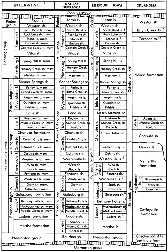
1. Recognition of subgroups of Kansas City is optional. Also, units such as Stanton, Plattsburg, Chanute, and others having composite lithologic characters, may be designated as formations or as limestone, shale, et cetera, according to predominant type of constituent rock.
2. Frisbie limestone not recognized in Nebraska.
3. Called South Bend or Little Kaw limestone by McQueen and Greene 1938).
4. Called Rock Lake or Victory Junction Shale by McQueen and Greene (1938).
5. Called Stoner or Olathe limestone by McQueen and Greene (1938).
6. Westerville limestone included in Cherryvale shale by Clair (1943).
7. Winterset limestone classed as members of Dennis limestone by Clair (1943).
8. Galesburg and Ladore shale classed both as formation and member by McQueen and Greene (1938).
9. Bethany Falls, Hushpuckney, and Middle Creek classed as members of Swope limestone by Clair (1943).
10. Oakes (1940); stratigraphic placement of beds above Wann formation uncertain.
11. Oakes (1940) includes Lost City limestone member locally instead of Stark and Canfield, but in many places only Winterset member is present.
Pleasanton Group
Definition
Lowermost deposits of Missourian age, mostly of clastic nature, are called Pleasanton, a name first used in a stratigraphic sense by Haworth (1895) for rocks between the uppermost Pawnee limestone and base of the Hertha formation. Pleasanton was similarly used in Missouri until 1938 (McQueen & Greene), when it was revised to exclude Desmoinesian strata. In Kansas (Moore, 1932) and Nebraska (Condra, 1935) the name was dropped.
Despite previous variation in the span of beds defined as Pleasanton, recent agreement of the state surveys of Iowa, Kansas, Missouri, and Nebraska at the Lawrence conference should stabilize future application of this name to the interval from the basal Missourian disconformity to the base of the Hertha formation (Fig. 14). The now-accepted definition, which was first used by McQueen & Greene (1938), precisely corresponds to "Bourbon formation" or group as previously recognized in Kansas and Nebraska. Priority in application to the stratigraphic span that here is assigned to the revised Pleasanton and consistency in numerous publications make Bourbon preferable to Pleasanton, but the latter name has been accepted in the interest of obtaining uniform interstate nomenclature. It is deemed acceptable on the basis of the unanimous agreement as to revised definition. The name Bourbon, which has been used by the Kansas Geological Survey since 1932, will be suppressed. The Pleasanton deposits are classed as a group.
Distribution and Thickness
The outcrop of strata belonging to the Pleasanton group is distributed as a south-southwest trending belt which crosses southeastern Kansas from Linn County to Montgomery County (Fig. 15). The width of this belt ranges from two to six miles. In northwestern Missouri, the mapped width of Pleasanton outcrops becomes considerably greater, especially in Bates, Cass, and Grundy Counties.
Figure 15. Distribution of outcrops of the Pleasanton group in Kansas and part of Missouri. Southward from northern Labette County, Kansas, the Pleasanton beds are not differentiated as a unit owing to disappearance of the Hertha limestone, which marks the top. Equivalent strata in this region are classed as the Seminole formation and lower part of the Coffeyville formation.
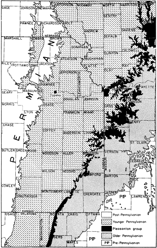
Inasmuch as most of the strata belonging to the Pleasanton group are fine-grained clastic sediments, which are non-resistant to weathering, the outcrop belt generally is covered by soil and vegetation; it forms a slope beneath the escarpment formed by lower limestone beds of the Kansas City group.
In southern Kansas (most of Labette County and southeastern Montgomery County) and in northeastern Oklahoma, the Pleasanton group cannot be differentiated from shaly and sandy beds which are equivalent to part of the Kansas City group. The Hertha limestone, which forms the base of the Kansas City group northward from Labette County, disappears southward. Rocks equivalent to the Pleasanton beds in this southern area are classed as the Seminole formation, below, and part of the Coffeyville formation, above.
The thickness of the Pleasanton group along its outcrop in Kansas ranges from 35 to 150 feet. Both exposed and buried parts of the group in eastern Kansas have greater thickness in the north than in the south. West of the Nemaha anticline (Marshall County to Sumner County) this rock division is reduced in thickness and seems to pinch out not far from the uplift. In eastern Nebraska, a few feet of clastic rocks which separate Marmaton and Kansas City beds are recognized as Pleasanton (Condra & Reed, 1943, p. 53); in its outcrop belt in western Iowa, the Pleasanton group ranges in thickness from a few to about 15 feet (Cline, 1941).
Lithologic Character
At the base of the Pleasanton rocks, lying unconformably on uppermost Desmoinesian strata, is the fairly persistent Hepler sandstone (Jewett, 1940, p. 8) (Fig. 16). This sandstone is believed to be the northward extension of the upper part of the Seminole formation of northeastern Oklahoma (Moore, et al., 1937, fig. 13; Oakes & Jewett, 1943, fig. 1). Probably it is nearly the time equivalent of the Chariton conglomerate of northern Missouri and southern Iowa (Weller, Wanless, Cline & Stookey,, 1942, fig. 1). Although the Hepler sandstone is persistent along its outcrop, it is replaced by shale or is very thin beneath the surface a short distance west of the Pleasanton exposures. In general, the Hepler is a sheet-like deposit and only locally in the northern part of the outcrop area and in near-by subsurface occurrence, this sandstone is found to fill sharply cut channels. Some of the channel fills are asphaltic where exposed, and some contain oil not far west of the outcrops.
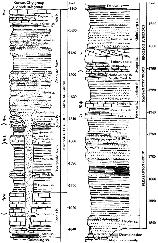
Figure 16. Generalized columnar section of the Pleasanton group and lower part of the Kansas City group in Kansas. These rocks comprise the lower part of the Missourian Series in eastern Kansas.
Several thin limestones are included in the lower part of the Pleasanton group. The lowermost of these in southern Kansas has been found to be the Checkerboard limestone (Oakes & Jewett, 1943), a thin but prominent marker bed which has been traced more than 150 miles southward in Oklahoma. In Kansas, the Checkerboard has not been identified north of Labette County but one of several thin limestones, which occur as far north as Bourbon or Linn Counties, may represent this unit. In Labette County, the Checkerboard limestone and underlying beds, including a thin deposit of coal and the Hepler sandstone, closely resemble a typical Cherokee cyclothem.
The lithologic character of the middle and upper parts of the Pleasanton group is highly variable. Thick black, carbonaceous shale, having characteristics of oil shale and containing dark limestone concretions to 2 feet in diameter, appears in southeastern Kansas. Farther north, in northern Bourbon and southern Linn counties, alternating layers of dark shale and dark flaggy limestone occupy the same position in the Pleasanton group; they range in total thickness to approximately 50 feet. Still farther north, in Linn and Miami counties, massive sandstone beds, some of which fill channels as much as 40 feet deep, are exposed. These sandstones collectively are called Knobtown sandstone (Greene, 1933, p. 13). In some areas the upper part of the Pleasanton contains very fine-grained, greenish sandstone, which is unlike most Pennsylvanian sandy deposits in the northern midcontinent. Such sandstone, together with carbonaceous shale and flaggy limestone, comprises a relatively minor portion of the Pleasanton group as a whole. Gray and brownish shale, some of which is unusually free from sand and contains marine fossils, is the dominant rock type.
In general, rocks of the Pleasanton group are more dominantly marine in southeastern Kansas than farther north in the state, a condition opposite to that of the overlying Kansas City and younger Pennsylvanian deposits. Locally in southern Kansas, the basal sandstone has a sandy limestone facies and contains marine invertebrates. The thick black shale accumulations and the alternating deposits of dark shale and flaggy limestone are seemingly nonfossiliferous, but marine fossils occur somewhat sparsely in the lighter-colored shale. The Knobtown sandstone in northeastern Kansas and western Missouri is judged to be a marine deposit which was transported to this area from an easterly source. It is significant that shale beds adjacent to and below channel fillings are almost entirely free of sand. Locally, a slight erosional disconformity is found at the top of the Pleasanton rocks, separating them from the Hertha limestone.
Marine invasions of eastern Kansas during early Missourian time when Pleasanton deposits were formed, probably came from the west and southwest. Land-derived clay and sand accumulated rather rapidly, and occasionally marine plants and animal remains formed calcareous beds east of the Nemaha anticline. Farther west, in the more open sea, deposition took place more slowly.
Kansas City Group
Definition
The Kansas City group was named (Hinds, 1912, p. 7) from exposures in the bluffs of the Missouri River and tributaries at Kansas City, Missouri. A revised definition of the group was adopted by the conference of state geological surveys at Lawrence in May 1947 (Fig. 14). The term is to be used in Iowa, Kansas, Missouri, and Nebraska but is not applicable to Missourian deposits in Oklahoma. The lower boundary of the group is placed at the base of the Hertha formation and the upper limit is drawn at the base of the Plattsburg formation. This modifies the originally designated limits by addition of the "Lane shale" of Missouri usage (Island Creek shale, Farley limestone, and Bonner Springs shale) at the top of the group, and to the same extent changes usage which has been followed by the Missouri Geological Survey since 1912. The new upper boundary of the Kansas City group coincides with definition of this line employed during the past 15 years in Kansas (Moore, 1932) and Nebraska (Condra, 1935), but the lower limit of the group (top of the Dennis formation) used by the Kansas and Nebraska surveys in recent years differs from the new definition which follows original Missouri survey usage and that followed in Iowa. Subdivisions of the Kansas City group, as previously defined and as now recognized, are shown in Figure 14.
The term Kansas City, especially in combination with the overlying Lansing as Kansas City-Lansing, has been very widely used by geologists in the northern midcontinent for designation of subsurface beds extending from Hertha to Stanton. Surface nomenclature adopted by the State surveys thus accords with that which has come to be accepted as best suited to subsurface requirements.
Distribution and Thickness
Rocks of the Kansas City group are very well exposed in and around Kansas City, Missouri, the type locality, and Kansas City, Kansas (Fig. 17). Outcrops appear in the bluffs of the Missouri and Kansas River Valleys and along tributary streams as far northwestward as Leavenworth and westward to the vicinity of De Soto, Kansas. The very irregular eastern margin of Kansas City outcrops in this region is marked by a prominent escarpment which trends northeastward across southern Clay County, Missouri, north of the Missouri River, and obliquely across Jackson and Cass counties, Missouri, east and south of Kansas City. From the Kansas City area the outcrop belt trends southwestward across eastern Kansas, the most important exposures of rocks belonging to the Kansas City group being found in Johnson, Miami, Linn, Anderson, Bourbon, Allen, Neosho, Wilson, Montgomery, and Labette Counties. Along most of this trend, the belt is 25 or more miles in width. Its eastern edge is topographically defined by the escarpment of lower Kansas City limestone beds. The western margin is similarly marked by the escarpment made by the Lansing limestones.
Figure 17. Distribution of outcrops of the Kansas City group in Kansas and parts of adjoining States. This group consists of escarpment-forming limestone formations and intervening shales and sandstones. South of central Montgomery County, Kansas, the outcrops shown on the map belong to the upper part of the Skiatook group (upper Coffeyville, Hogshooter, Nellie Bly, and Dewey formations) and lower part of the Ochelata group (Chanute, Iola, and lower Wann beds).
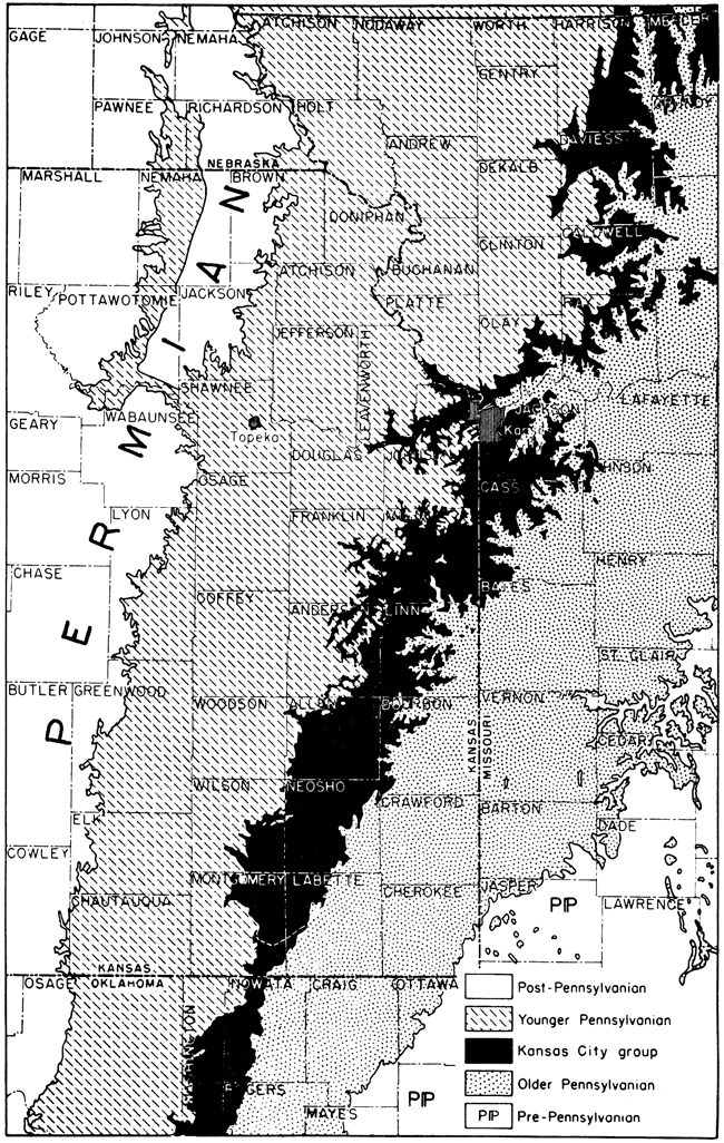
Southward from east-central Montgomery County, Kansas, the rocks equivalent to the Kansas City group are not differentiated lithologically or topographically from strata below and above in such manner as to make recognition of the group readily possible. It is not a natural assemblage of beds. The rock succession of Missourian age in this region near the Kansas-Oklahoma boundary and southward across eastern Oklahoma, accordingly, is classed in two groups called Skiatook, below, and Ochelata, above. Equivalents of the Kansas City group are mainly clastic deposits. Their stratigraphic classification is shown in Figure 14.
The Kansas City group is the thickest division of the Missourian Series. It is about 350 feet thick in the latitude of Iola and 275 to 325 feet thick in the Kansas City area. Northward thinning of beds belonging to the group is shown by measurements of 165 feet in Richardson County, southeasternmost Nebraska, and 100 feet in the Platte Valley, south of Omaha.
Lithologic Character
As a whole, the Kansas City group is characterized by prominence of relatively thick, persistent limestones (Fig. 16). Between the limestones are shales of varying thickness, predominantly light-colored and clayey to sandy in composition. Thin but very persistent black platy shale units are associated with most of the limestone formations of the Kansas City group. Sandstone is not a prominent constituent of this division of the Pennsylvanian rocks in northeastern Kansas but it increases in abundance southward to such extent that between the latitude of Iola and the Kansas-Oklahoma boundary sandstone is quantitatively as great or greater than limestone in the Kansas City group. Most of the sandy deposits are thin-bedded and fine-grained but some deposits are fairly thick-bedded and medium- to coarse-grained. Coal beds are found in the middle part of the Kansas City group. Most layers are very thin and impersistent, but the Thayer coal, which attains a thickness of 29 inches (Schoewe, 1944, p. 97) in Montgomery County, Kansas, is mined at several places.
Some of the rock subdivisions of the Kansas City group are amazingly uniform in lithology and thickness, whereas others are decidedly variable in physical features and show somewhat erratic changes of thickness. Physiographically, the group is characterized by well-defined escarpments which mark the outcrop of limestone formations, especially the Dennis, Iola, and Wyandotte.
Much of the variability of Kansas City beds, including especially southward change of facies, seems to be correlated with successive uplifts in the area of the Chautauqua arch (Barwick, 1928, p. 177), which is a pre-Mississippian westward-trending extension of the Ozark uplift in southern Kansas and northern Oklahoma. The more striking structural features of the arch were formed by warping before Mississippian sedimentation, for the Mississippian rocks progressively overlap the truncated older Paleozoic formations of the arch. Movements occurred at intervals throughout middle Missourian time and culminated in regional warping late in the Missourian Epoch. There has long been such difficulty in tracing Oklahoma equivalents of Kansas City beds (for example, the Hogshooter, Dewey, and Avant limestones) into the standard Kansas section, that the question of correlation has come to be known as the "State Line Problem". Many of the difficulties lie in the existence of overlaps, long unrecognized, in connection with which key horizons are cut out locally, and in the abnormal thinning of many units over the high area along the State boundary. Features of middle Missourian sedimentation which show definite relation to the Chautauqua arch include: (1) overlaps from the south and north across higher parts of the arch, (2) thinning of marine units in this area, (3) greater proportion of nonmarine and channel deposits over the arch, and (4) a striking duplication of facies in northeastern Kansas and northeastern Oklahoma areas, which are separated by rocks showing very different lithologic facies in the intervening territory near the Kansas-Oklahoma boundary.
Cyclic Sedimentation
Deposits included in the Kansas City group exhibit regularities of sequence which denote both cyclothems and the arrangement of successive cyclothems of differing character which belong to so-called megacyclothems (Moore, 1936, p. 29). Simple cyclic sequences are represented by nonmarine sandstone, overlain by sandy to clayey shale containing land plant remains, underclay, a coal bed, and shale or limestone containing marine fossils. Some of the marine beds contain invertebrates interpreted as representing a very near-shore assemblage; in such faunas, are inarticulate brachiopods, certain types of calcareous brachiopods (Derbyia, Juresania) in abundance, thick-shelled clams (especially Myalina) and radially ribbed scallops (Aviculopecten and other genera), associated with more or less common snails (especially bellerophontids) and some bryozoans. Off-shore faunal assemblages are characterized by a varied group of marine invertebrates and particularly the wheat-grain foraminifers called fusulinids (Triticites in Kansas City beds). Algal limestones occur at the top of several limestone formations of the Kansas City group, and these beds evidently represent the shallow-water deposits of retreating phases of the marine inundations.
Features of cyclic sedimentation observed in part of the Kansas City group of eastern Kansas and in lower Lansing beds are indicated graphically in Figures 18 and 19, which show correlation of elements belonging to a number of different cyclothems. The stratigraphic position of the respective cyclothems is recorded by the index section on Figure 18.
Figure 18. Sections of lower Lansing and upper Kansas City beds showing cyclothems grouped in megacyclothems. The individual cyclothems are indicated by the letters B, C, and D. Megacyclothems comprise the entire sequence of beds in any one of the three plotted sections, M, N, O. Stratigraphic position of the sequences is shown on the index section in Figure 19.
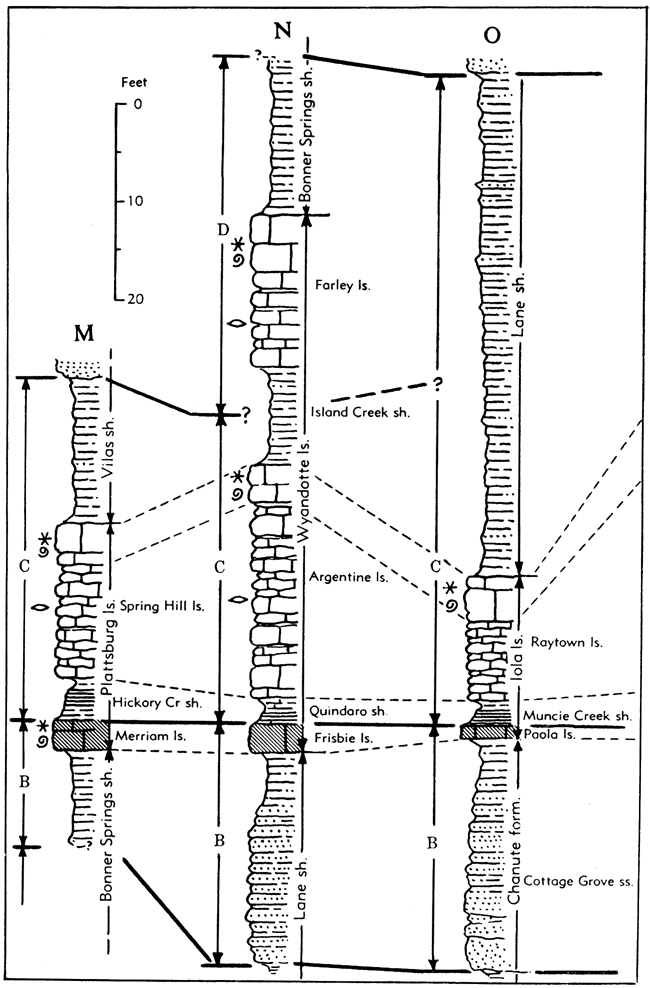
Figure 19. Sections of lower Kansas City beds showing cyclothems and megacyclothems. These units are differentiated as explained in description of Figure 18.
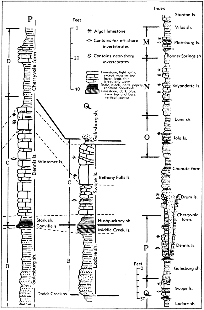
The cyclothems designated by the letter "B" are mostly distinguished by presence of sandstone at the base and medium- to dark-blue dense brittle vertical-jointed massive limestone at the top. Invariably, the upper limestones of the "B" cyclothems are characterized by thinness--a few inches to 4 or 5 feet maximum. A coal bed occurs between the basal sandstone and the upper limestone of some of these cyclothems.
The cyclothems which are marked by the letter "C" are characterized by the distinctive carbonaceous black platy shale layer, a few inches to 3 or 4 feet thick, at the base. The black shale is overlain by thin light-colored shale and this in turn by thick light-gray to nearly white fine-textured limestone which typically occurs in thin uneven beds separated by wavy shale partings. The thin-bedded wavy limestone contains a varied assemblage of marine invertebrates, generally including fusulinids. The top portion of the limestones is massive or thick-bedded, nodular or even-textured, and commonly somewhat siliceous; it contains algal remains and where invertebrates are found, the assemblage is dominated by mollusks, a.few brachiopods belonging to certain genera (especially Composita), and some bryozoans. Oö1ite occurs in the position of this algal limestone and in no other part of the section. The thick light-colored limestone is overlain by clayey to sandy shale which is mostly unfossiliferous.
Cyclothems indicated by the letter "D" are differentiated less definitely and they are not characterized generally by the distinctive peculiarities of the "B" and "C" sequences. Wherever recognized, they are clearly separable from subjacent and superjacent cyclothems by deposits which denote retreat of marine waters, whereas the central part of such cyclothems records more or less off-shore sedimentation during marine submergence.
The index letters employed for designation of cyclothems shown in Figures 18 and 19 correspond to those used in drawing the Shawnee megacyclothems. Correspondence of the "B" and "C" cyclothems in the Missourian and Virgilian parts of the Upper Pennsylvanian section respectively, is obvious. It is interesting to observe that nowhere in the Kansas City and Lansing groups are known to exist distinct equivalents of the "A" cyclothems of Shawnee megacyclothems, although these are strongly marked features of the latter.
Classification
The strata included in the Kansas City group are judged to be divisible advantageously into three main parts of subequal thickness, which are treated as subgroups. In upward order, these are called Bronson, Linn, and Zarah (Fig. 14). They differ in dominant lithologic characteristics and are bounded by unusually persistent marker beds.
The Bronson beds are distinguished by prominence of persistent limestone formations, in upward order called Hertha, Swope, and Dennis. Between these units are predominantly shaly deposits named the Ladore and Galesburg formations, which increase in thickness southward and contain a good deal of sandstone.
The Linn subgroup forms the middle part of the Kansas City group in which shale, associated with mostly rather thin limestones, is a characteristic lithologic feature. Formations recognized in this part of the section, in upward order, are named Cherryvale, Drum, Chanute, and Iola. The limestone units tend to thicken locally. Shale and sandstone predominate toward the south.
The Zarah portion of the Kansas City group contains the Lane shale at the base, Wyandotte formation (mainly limestone) in the middle, and Bonner Springs shale at the top. The Wyandotte beds are prominent in the Kansas City region and northward but disappear about 75 miles southwest of Kansas City. Where the Wyandotte is absent, the Zarah subgroup comprises the Lane-Bonner Springs shale.
Bronson Subgroup
General Description
The lower main division of the Kansas City group, as now defined, consists of the old "triple limestone" (Haworth, 1895, p. 458), which was named Bronson by Adams (1904). It extends from the base of the Hertha formation to the top of the Dennis formation (Fig. 16). Along the outcrop from central eastern Kansas into Iowa, the Hertha, Swope, and Dennis formations are respectively separated by relatively thin shales and they form a well-defined escarpment which rises above the Pleasanton lowland belt.
The uppermost Bronson unit (Winterset limestone) extends as far southward as T. 8 N. in Oklahoma, some 60 miles south of Tulsa, but the Hertha disappears before the Kansas-Oklahoma State line is reached. Where the normal, lower boundary of the subgroup (and group) can be followed no longer, classification must be modified by reducing the stratigraphic span so as to include only units that can be recognized and traced, or nomenclature suited to northern territory must be discarded in favor of different terminology that is adapted to southern Kansas and northeastern Oklahoma. The latter course has been followed. South of the point where the Hertha disappears, lower Missourian deposits are referred to the Skiatook group. Rocks equivalent to the Bronson subgroup are named, in upward order, Coffeyville formation and Dennis formation (Hogshooter limestone in Oklahoma).
Bronson rocks are partly marine and partly nonmarine. In the north, where the total thickness is less than 100 feet, almost the entire section is composed of sediment that accumulated on the shallow sea floor. In this area considerably more than half of the subgroup consists of limestones separated by thin shales, which seemingly are mostly marine. Farther south, the shale formations are thicker and they merge into largely nonmarine deltaic deposits, which extend far southward into the Oklahoma basin. The Bronson limestones are calcareous tongues which divide the clastic deposits.
Chert is present in nearly all limestone units of the Bronson subgroup. It is conspicuous in the Winterset and Bethany Falls limestones and is not confined to any one type of limestone. Crossbedded oölitic (algal) limestone replaced by chert furnishes evidence of the secondary origin of some of the chert. Also, the chert in some limestones is most plentiful in places where the rocks have been longest exposed.
The thickness of the Bronson subgroup ranges from about 55 feet in the Platte Valley of Nebraska to about 175 feet in southern Kansas. The average thickness of this division in the vicinity of Kansas City is about 80 feet and in the latitude of Iola, about 100 feet.
Bronson rocks, associated with a few underlying and overlying beds, comprise three megacyclothems which may be designated Hertha, Swope, and Dennis. Each is composed of two or more cyclothems in which individual phases generally are not as distinct as in some other parts of the section.
Hertha Limestone
The lowest formation of the Kansas City group, which is called Hertha (Adams, in Adams, Girty, & White, 1903, p. 35), is divisible into three members, in upward order called Critzer limestone, Mound City shale, and Sniabar limestone (Fig. 16).
The limestone members vary somewhat in lithologic features from place to place, and each may exhibit characters seen in the others. Accordingly, they are distinguished most readily and definitely by their position below and above the distinctive Mound City shale member. The Sniabar limestone is more persistent than the Critzer member, but locally the latter is by far the most conspicuous part of the Hertha formation. The three members are identified as far south at T. 32 S., R. 19 E., Labette County, Kansas, and as far north as southern Jackson County, Missouri. The southernmost exposure in which identifiable Hertha beds have been seen is in southwestern Labette County (sec. 19, T. 33 S., R. 18 E.), 11 miles north of the Kansas-Oklahoma boundary. Calcareous shale equivalent to part of the Hertha formation is recognized, however, in a zone about 135 feet below the top of the Coffeyville formation in southeastern Montgomery County, near the Oklahoma border. Along its outcrop in Kansas, the formation ranges in thickness from a few inches to about 30 feet.
The Hertha formation is identified at various points in northwestern Missouri and is known to extend into Iowa, whee it is overlapped by Cretaceous beds. In eastern Nebraska, the Hertha is exposed in the Platte Valley and along the Missouri River at Jones Point near the mouth of Weeping Water Creek, north of Nebraska City (Condra, 1930). The formation can be identified in cuttings from wells west of its outcrop area in eastern Kansas, northwestern Missouri, southwestern Iowa, and eastern Nebraska.
Critzer limestone member. The Critzer limestone (Jewett, 1932, p. 99) lies next above uppermost Pleasanton beds and is overlain by the Mound City shale. Locally, it is separated from the Pleasanton group by a disconformity. As seen in most exposures, the Critzer is a light-gray, sandy, impure, massive limestone ranging from 2 to 5 feet in thickness. In southern Kansas. where it becomes thinner, this member is composed of nodular, hard, dark limestone, probably of algal origin.
Normally, the lower part of the Critzer limestone contains a molluscan fauna characterized by large bellerophontid gastropods; the middle part commonly bears corals and brachiopods; and the upper part consists of algal limestone. In many northern outcrops, the molluscan facies comprises the whole member and the rock appears as a single massive bed. At some places, it is almost entirely made up of thin-and-wavy bedded gray limestone containing corals and brachiopods, the lower molluscan and upper algal phases being inconspicuous or absent.
The thickness of the Critzer limestone ranges from a few inches to about 11 feet along its outcrop in Kansas. Where thick, it commonly forms a rimrock above steep slopes developed on Pleasanton beds.
Mound City shale member. The middle member of the Hertha formation, called the Mound City shale (Jewett, 1932, p. 99), ranges in thickness from a featheredge to 8 feet, the average being about 5 feet. The greatest thickness is in the northern part of the outcrop area. Where well developed and well exposed, this shale is divisible into three parts: (1) a lower nonfossiliferous, blocky gray shale, which locally is black; (2) a thin bed of crinoidal limestone or zone of limestone nodules; and (3) an upper blocky gray shale rich in chonetid brachiopods, ramose bryozoans, and (locally) small horn corals and crinoid fragments. A thin bed of coal, which is observed in western Missouri in the lower part of the Mound City shale, probably corresponds to the black shale. The lower gray shale contains chonetid brachiopods and some other fossils; pectinoid clams and phosphatic-shelled brachiopods (Orbiculoidea, Lingula) have been found in the black shale.
Sniabar limestone member. The upper member of the Hertha formation called the Sniabar limestone (Jewett, 1932, p. 99), includes all limestone and shale beds in the formation above the Mound City shale. In places where the Critzer member is absent and the Mound City shale cannot be differentiated from upper Pleasanton beds, this limestone comprises the entire Hertha formation.
The Sniabar is dominantly a fine-grained gray limestone which weathers brown. Along most of its outcrop in Kansas, this limestone is a massive resistant ledge, but locally it is a thinly wavy-bedded rock which breaks down into slabs. In southern Kansas, silty layers alternate with purer limestone, and shale partings are common.
Coralline limestone, bearing abundant Aulopora, locally comprises nearly the entire thickness of the Sniabar member, but corals are more characteristic of the basal part. In some places, however, the lower few inches is composed almost wholly of crinoid fragments. Productid brachiopods (Marginifera) are very common in this limestone at places in southern Kansas. Algal limestone commonly forms the uppermost part of the member.
In Kansas the thickness of the Sniabar limestone ranges from a few inches to about 11 feet.
Ladore Shale
The Ladore (Adams, 1904, p. 18) is a clastic formation between the Hertha and Swope limestones (Figs. 14, 16). It lies above the Sniabar and below the Middle Creek limestone, but south of central Neosho County, where the Middle Creek disappears, the Ladore shale is overlain by the middle shale member (Hushpuckney) of the Swope formation. Since such a contact of shale-on-shale generally cannot be distinguished, the combined beds are designated as Ladore-Hushpuckney. The Ladore beds are the northward equivalent of part of the Coffeyville formation, which is recognized southward from west-central Labette County, Kansas.
A strikingly abrupt change in thickness and lithology of the Ladore shale is observed in southeastern Allen County, Kansas. North of the line between T. 25 S. and T. 26 S. it is marine shale containing locally limestone nodules and nodular limestone, the thickness of the entire Ladore being only 2 feet or a little more. Much of the limestone shows evidence of algal origin. Southward from the line mentioned, the shale expands rapidly to 20 feet or so of sandy deltaic deposits, in which sandstone and coal appear. In southern Neosho County and farther south, these sandy Ladore deposits are 60 to 70 feet thick.
Swope Limestone
The Swope formation (Moore, 1932, p. 90) includes beds above the Ladore shale from the base of the Middle Creek limestone to the top of the Bethany Falls limestone (Figs. 14, 16). The expression of cyclothem units arranged in megacyclic sequence is closely comparable to that seen in limestone formations of the Shawnee group, Virgilian Series. The lower Swope limestone (Middle Creek) has typical lithologic features of the thin, dense, vertical-jointed limestone which belongs to the cyclothem next above the lowermost cyclothem of Shawnee megacyclothems and the black platy middle Swope shale (Hushpuckney) and the upper Swope limestone (Bethany Falls) match corresponding strata of the third cyclothem of the Shawnee megacyclothems. No other equivalents of Shawnee cyclic units are distinguished.
The thickness of the Swope limestone at the type locality, in the southeast part of Kansas City, Missouri, is about 30 feet. This is the average thickness of the formation northeastward into Iowa and southward to Bourbon County, Kansas, east of Chanute. Farther south, the limestone gradually becomes thinner and disappears a few miles south of Mound Valley, in Labette County.
Middle Creek limestone member. Named from outcrops near LaCygne in eastern Linn County, the Middle Creek limestone member (Newell, in Jewett, 1932, p., 101) of the Swope formation conformably overlies the Ladore shale and is overlain by black fissile shale of the Hushpuckney shale member of the Swope (Fig. 19). It is a dark bluish, dense, hard, brittle, even-textured limestone, which in most outcrops shows vertical joints. The thickness of the member ranges from a few inches to about 8 feet, the maximum being observed in western Bourbon County. The thickness in any one region shows very slight change. The limestone is identifiable in northwestern Missouri and Iowa, but disappears southward in central Neosho County, Kansas.
Hushpuckney shale member. Very persistent shale between the two limestone members of the Swope formation has been named the Hushpuckney shale (Newell, in Jewett, 1932, p. 101). The lower part of the shale is black and fissile; it contains few observed fossils other than conodonts and other microfossils. The upper half to two thirds of the member consists of bluish or bluish-gray clay shale (Fig. 19). The thickness of the Hushpuckney shale ranges from 3 to 6 feet, the average being 4 feet. The member is distinguishable in northwestern Missouri and across eastern Kansas as far as Erie, where the Middle Creek limestone, which separates it from the Ladore shale, disappears.
Bethany Falls limestone member. The Bethany Falls limestone (Broadhead, 1866, p. 320) is the main limestone unit of the Swope formation, occurring above the Hushpuckney shale and beneath the Galesburg shale. The name is derived from the vicinity of Bethany, county seat of Harrison County, in northwestern Missouri. It is somewhat variable from place to place, but can be identified at most outcrops very readily and definitely. The Bethany Falls is traced from south-central Iowa to southern Kansas not far from the Oklahoma boundary.
Two chief subdivisions of the member are recognized--(1) a lower unit consisting of light-gray, dense, thin-bedded limestone, which occurs in uneven, somewhat wavy layers separated by shale partings and (2) an upper unit consisting of very light gray massive, nodular or oölitic limestone. The lower unit which ranges in thickness from less than 1 foot to about 20 feet (average about 12 feet) contains fairly abundant fossils consisting mostly of brachiopods and bryozoans (Figs. 16, 19). The upper subdivision of massive nodular limestones ranges in thickness up to about 7 feet, and where it is represented by oölite, to about 13 feet. This unit is mostly unfossiliferous and is judged to be algal in origin. At many places the oölitic part of the Bethany Falls, which may show cross-bedding, is weathered so that the oölitic granules are removed by solution, leaving the material between the oölites behind; accordingly, the rock is very porous. The oölitic phase of the upper Bethany Falls limestone is widely developed in Kansas south of the Kansas River, but is not common northeastward. The total thickness of the Bethany Falls limestone ranges from about 12 to 27 feet, the average in eastern Kansas being about 18 feet.
The outcrop of the Bethany Falls limestone is marked in many places by the occurrence of large joint blocks, 10 to 20 feet in diameter, which have moved various distances down hillsides owing to creep. No other limestone of the Missourian section exhibits this feature so commonly as the Bethany Falls limestone. It is well shown in many ravines near Kansas City.
Galesburg Shale
The Galesburg shale (Adams, in Adams, Girty, & White, 1903, p. 36) includes predominantly shaly strata between the Swope and Dennis limestones (Figs. 14, 16). Type exposures are near Galesburg in southern Neosho County, Kansas. The Bethany Falls limestone member of the Swope occurs everywhere next below the Galesburg. Throughout east-central Kansas, rock next above the Galesburg shale is the Canville limestone which is the basal member of the Dennis formation, but in northeastern Kansas and northwestern Missouri, the Galesburg is directly overlain by the Stark shale member of the Dennis. In southern Kansas and northern Oklahoma, the only recognizable member of the Dennis is the Winterset limestone. The upper boundary of the Galesburg formation, therefore, shows more varied relationships than the lower.
The Galesburg formation near Galesburg, Kansas, comprises about 70 feet of unfossiliferous gray and brown clayey to sandy shale, and near the top, some sandstone. Sandstone becomes increasingly prominent southward, and there are several fairly persistent thin coal beds. It is worthy of notice that the nonmarine facies of the Galesburg formation extends farther northward than nonmarine deposits of the Ladore shale. In western Bourbon County, near Uniontown, the Galesburg shale is about 10 feet thick. At Kansas City, it consists of 2 to 3 feet of buff calcareous nodular shale which is readily separated from the overlying black, fissile Stark shale, even though no limestone (Canville) intervenes.
Although very thin in northeastern Kansas and northwestern Missouri, the Galesburg shale is traceable into Iowa. The southern limit of the Galesburg as a distinct stratigraphic unit is in southern Labette County, Kansas, for the Swope limestone disappears in this region. To the south the Galesburg merges with the upper part of the Coffeyville rocks.
Dennis Limestone
The Dennis limestone (Adams, in Adams, Girty, & White, 1903, p. 36) is the uppermost formation of the Bronson subgroup. It overlies the Galesburg shale and is succeeded conformably by the Cherryvale shale. (Figs. 14, 16, 19). Near Dennis, in northwestern Labette County, and for a considerable distance northward, the formation contains three members: (1) the thin blue dense blocky Canville limestone at the base, (2) the black fissile and gray or buff Stark shale in the middle, and (3) the thick gray or blue, thin-bedded or in part massive, oölitic Winterset limestone at the top. Along many miles of Dennis outcrop, the upper limestone not only constitutes the main element of the formation, amounting to 90 percent or more of the total thickness, but it includes all limestone beds belonging to the Dennis; the Canville limestone member at the base is missing. In such areas, the stratigraphic span of the Dennis formation commonly is not restricted to that of the Winterset member, because the Stark shale can be distinguished readily from the underlying Galesburg shale. The Dennis limestone, in many places may thus consist of two members, the Stark shale, below, and the Winterset limestone, above.
The thickness of the Dennis limestone ranges from 5 or 6 feet, in an area a few miles southwest of Coffeyville, to more than 70 feet. The Winterset and Stark members are continuous to south-central Iowa, and the Winterset extends to southern Oklahoma, where it is the main (or only) component of the formation called Hogshooter limestone.
Canville limestone member. The Canville limestone (Jewett, 1932, p. 102), named from a locality in Neosho County, overlies the Galesburg shale and is next beneath the Stark shale (Figs. 16, 19). It is a fine-grained, dense, hard rock which shows prominent vertical joints. As seen at some outcrops, it is a single layer about 1 foot thick, but where the thickness is greater, up to an observed maximum of about 3 feet, two or three beds may occur. The member becomes thin southward from the type region and is not known in Kansas south of Erie, in central Neosho County, although it reappears locally in Oklahoma. The Canville disappears also near the Linn-Miami County line, some 40 miles south of Kansas City and is not seen farther north. The known area of its development, therefore, is confined to Neosho, Bourbon, and Linn counties, Kansas. In terms of relation to cyclic sedimentation, the Canville member is exactly homologous to the Middle Creek limestone, representing the same part of the Dennis megacyclothem that the Middle Creek is in the Swope megacyclothem. Both of these limestones are dense blue vertical-jointed strata occurring next below black platy shales.
Stark shale member. The middle member of the Dennis limestone is named Stark shale (Jewett, 1932, p. 102), from a village in Neosho County, Kansas. It occurs above the Canville limestone wherever the latter is present and lies below the Winterset limestone (Figs. 16, 19). North of the point in Linn County where the Canville limestone disappears, the Stark shale rests directly on Galesburg shale, but because the lower part of the Stark member is hard, black, fissile shale, which is very unlike the soft, light-colored, nonfissile Galesburg, the contiguous shales are differentiated easily. The contact between them is sharp.
The Stark shale normally consists of two parts--a lower unit of black fissile shale, 1 to 3 feet thick, and an upper unit consisting of gray or buff, calcareous to clayey shale, 2 to 5 feet thick. At Kansas City, the total thickness of the Stark member is about 4 feet. The black shale contains conodonts and macerated plant remains. Small phosphatic concretions occur commonly. The upper shale contains a varied brachiopod and pelecypod fauna in many places. The most common fossils are Derbyia crassa and Aviculopecten. The distinctive brachiopod Liorhynchus rockymontanum is found in this shale at Kansas City.
Winterset limestone member. The uppermost member of the Dennis limestone, named the Winterset limestone (Tilton & Bain, 1897, pp. 517-519), is defined from outcrops in Iowa a few miles southwest of Des Moines. In normal sequence, the Winterset rests on the Stark shale and is overlain by shale belonging to the Cherryvale formation (Figs. 16, 19). From central Neosho County, Kansas, northeastward to Iowa, the Winterset rests on the Stark shale, which along this part of the outcrop can be identified as a distinct stratigraphic unit, whether the Canville limestone underlies it or not. In territory south of Neosho County, except locally, roughly coincident with disappearance of the Canville, the Stark loses its diagnostic physical characters so that a boundary between it and the underlying Galesburg shale cannot be defined. Inasmuch as field observations indicate that the few feet of shale occurring next below the Winterset limestone unquestionably is continuous laterally with Stark beds, the Galesburg shale, combined with Stark shale equivalents, may be designated appropriately as Galesburg-Stark shale. Because a definite boundary cannot be drawn at the base of presumed Stark beds, the Dennis formation may be defined as composed of one member--the Winterset limestone. Underlying shale equivalent to the Stark, is, in effect, classified as uppermost part of the Galesburg formation.
The Winterset limestone is typically a light bluish-gray to bluish, fine-grained limestone which occurs in somewhat uneven to distinctly wavy thin beds separated by thin shale partings. In places the lower part is thick-bedded, dark-gray limestone which contains abundant fine, very irregular primary calcite "veins", which probably represent algal. structures. Beds of shale, including some black platy beds a foot or more thick, occur in a number of sections of the Winterset limestone. Near the top a prominent zone of very dark-gray to black chert concretions is found commonly, and in places this type of chert occurs in the middle part of the member. The associated limestone beds may be distinctly siliceous. Light-gray oölitic limestone is present at the top or in the upper half of the member locally, especially in east-central Kansas. Farther south, irregularly bedded, pseudo-brecciated and "veined" light-gray limestone is prominent in the upper part of the member. This rock, which is probably algal in origin, has a thickness of more than 50 feet in some areas. Near Cherryvale and Coffeyville, the typical Winterset limestone is succeeded by very dense dark-blue, fine-grained siliceous to sandy limestone beds interbedded with shale. These beds are unfossiliferous flagstones.
Fossils are abundant at many places in the Winterset limestone. The thin wavy-bedded strata commonly contain numerous brachiopods, including especially abundant shells of small productids (Marginifera), and bryozoans. The siliceous and oölitic beds contain numerous pelecypods and gastropods. Large nautiloid cephalopods and some ammonoids have been collected in the Winterset limestone of the Kansas City area (Miller, Lane, & Unklesbay, 1947). Fusulinids of the Triticites irregularis type are numerous in some of the brachiopod-bearing beds. Well-preserved land plant remains have been collected from shaly beds of the member.
The equivalence of the Winterset limestone to the Hogshooter limestone of Oklahoma has been determined by tracing outcrops and by comparison of sections at frequent intervals along the outcrops.
Linn Subgroup
General Description
The middle portion of the Kansas City group, from the base of the Cherryvale formation to the top of the Iola formation, is defined as the Linn subgroup (Moore, 1948), named from Linn County, Kansas, which contains excellent exposures of all constituent units (Fig. 14, 16). The subgroup is characterized by relative prominence of shale, but there are persistent limestones, mostly only a few feet thick, and locally much sandstone. A main reason for this segregation of beds is the regularity of stratigraphic units belonging to it, in contrast to variability of limestone and shale subdivisions belonging to the upper part of the Kansas City group. Also, the top of the Linn division has been found to be one of the best datum planes for structural mapping. It is thus employed in oil and gas exploration, especially in western Missouri and parts of eastern Kansas. The Linn subgroup comprises the Cherryvale formation, the Drum limestone, the Chanute formation, and the Iola limestone. The average thickness in Kansas is approximately 110 feet.
A prominent disconformity occurs within the subgroup (at the base of the Chanute shale), and at several places it extends down to or into the Bronson beds. No seemingly significant faunal change is associated with this break but it indicates unusual physical changes incident to the close of one megacycle (Drum) and the beginning of another (Iola). Irregularities in sedimentation in beds next above this disconformity are most strikingly seen from the vicinity of Chanute southward. They are associated with warping of the Chautauqua arch in southern Kansas. In northeastern Oklahoma and extending a short distance into Kansas, this disconformity is designated as the boundary between the Skiatook group, below, and the Ochelata group, above.
Cherryvale Formation
The Cherryvale formation (Haworth, 1898, p. 47) includes beds from the top of the Winterset limestone to the base of the Drum limestone (Figs. 14, 16). At its type locality, in the vicinity of Cherryvale, Montgomery County, Kansas, the section consists entirely of bluish-gray, clayey to silty shale, but farther north there are persistent limestones (Block, Westerville) which extend into Iowa and Nebraska. These limestones and the shale subdivisions lying below and above them are classed as members of the Cherryvale formation. The average thickness of the Cherryvale formation in Kansas is about 60 feet.
Fontana shale member. The basal part of the Cherryvale formation is the Fontana shale member (Newell, in Moore, 1932, p. 91), named from a village in Miami County. It conformably overlies the Winterset member of the Dennis limestone and underlies the Block limestone (Figs. 16, 19). It is a fairly uniform clay shale of greenish-gray to buff color, which contains scattered calcareous nodules. Locally, ferruginous calcareous shale occurs at the base. The member is mostly barren of fossils, but near the top, abundant specimens of the small brachiopod Chonetina flemingi var. plebeia are common in many places.
The Fontana shale is 15 feet thick near Fontana and about 5 feet thick in the vicinity of Kansas City. Southward the shale thickens to 25 feet in Linn County. Since the Winterset and Block limestones are found at various places in northwestern Missouri and southern Iowa, the Fontana shale can be recognized from Linn County, Kansas, to Iowa, but it is not differentiated from other Cherryvale beds south of Linn County.
Block limestone member. The Block limestone (Newell in Moore, 1932, p. 91), named from a small settlement in Miami County, occurs conformably between the Fontana shale, below, and the Wea shale, above (Figs. 16, 19). It is a blue-gray, fine-grained, hard limestone which occurs in moderately thick even beds, commonly intersected by vertical joints. At some outcrops the beds are thin and wavy or nodular, and near Kansas City this member is composed of several thin dense blue limestones separated by a few inches to a foot or two of shale. Fusulinids are common in the Block limestone and the brachiopod Marginifera wabashensis is abundant at many places.
The thickness of the member ranges in most places from 3 to 8 feet, the average being about 4 feet. The unit has been identified at exposures from Linn County, Kansas, northward to Iowa, but has not been traced south of Linn County.
Wea shale member. The Wea shale (Newell, in Moore, 1932, p. 91), named from outcrops in northeastern Miami County, occurs next above the Block limestone and is overlain by the Westerville limestone. The shale is mostly olive-green in color and clayey, but a persistent thin zone of maroon silty to clayey shale occurs near the top. The shale is more calcareous to the north.
The thickness of the Wea shale in eastern Kansas ranges from about 10 to 30 feet, the greatest thickness being observed in eastern Johnson County, a few miles southwest of Kansas City. The unit is traceable across northwestern Missouri into Iowa, but south of the type region, the Westerville limestone is mostly missing, so that the shales below and above this limestone are not clearly separable. The stratigraphic relationships of the shales can be determined in well-exposed sections because of lithologic distinctions between the Wea and Quivira shales. It is not practicable, however, to draw a boundary at the top of the Wea shale where the Westerville limestone is absent, and the shale between the Block and Drum limestones is designated as Wea-Quivira shale. Likewise, this member cannot be differentiated from the underlying Fontana shale in mapping where the Block limestone is absent.
Westerville limestone member. A persistent and distinctive stratigraphic unit in the vicinity of Kansas City and northward to the type area in Iowa, a few miles southwest of Des Moines, is the Westerville limestone (Bain, 1898a, pp. 276-277). It is identified in Nebraska, but seems to be absent south of Miami County, Kansas. The Westerville member occurs next above the Wea shale and underlies the Quivira shale.
The lithologic characters shown by Westerville beds in northeastern Kansas and northwestern Missouri are much more variable than those of adjacent limestone units. Commonly, a lower and upper division can be distinguished, the former by its fine texture and moderately thin, somewhat uneven bedding, and the latter by prominence of massive or cross-bedded oölite-like algal limestone. This algal limestone has been extensively used as building stone in the Kansas City area, and is known as the "Kansas City oölite". Both parts of the member are light bluish-gray to nearly white, and weather gray or buff, but their appearance, nevertheless, is quite different one from the other. In places the upper Westerville is dense, siliceous, chert-bearing rock, which weathers light brown. In the Kansas City area fossils are uncommon except in the oölite, which yields a rich fauna of mollusks, brachiopods, bryozoans and various other invertebrates. Many fossils described by Sayre (1931) from the Kansas City area were obtained from oölitic limestone which was thought to be Drum limestone (equivalent to the oölitic, richly fossiliferous Corbin City member of southern Kansas), but actually came from the Westerville limestone. In northern Missouri, Iowa, and Nebraska, oölite is not common in the upper Westerville and the fine-grained light blue-gray rock which generally makes up most of this member contains very abundant small fusulinids.
The thickness of the Westerville limestone averages about 8 feet.
Quivira shale member. The Quivira shale (Newell, in Moore, 1932, p. 91) comprises strata between the Westerville limestone, below, and the Drum limestone, above. Type outcrops occur a few miles west of Kansas City, in Johnson County, Kansas. It consists mostly of unfossilferous olive-green clay shale, but in most sections about 1 foot of black carbonaceous shale containing corneous brachiopods is found in the upper part and in some outcrops about the same thickness of maroon clay shale occurs at the base. The middle part of the Quivira shale in the Kansas City area contains a rather inconspicuous nodular light gray limestone. The upper part contains nonmarine deposits, including underclay and coal, which are overlain by a thin dense limestone, calcareous, fossiliferous shale, and black platy shale, which bears Orbiculoidea and Lingula. These are characteristic phases in normal order representing parts of two successive cyclothems.
The thickness of the Quivira shale in northeastern Kansas ranges from 4 to 11 feet. In the Kansas City area, the thickness averages 7.5 feet. The Quivira is differentiated only in the region from Miami County northward across Johnson and Wyandotte Counties, Kansas; in Jackson and Platte Counties, Missouri; and in southeastern Nebraska.
Drum Limestone
In central Montgomery County, Kansas, where the type locality of the Drum limestone (Adams, in Adams, Girty, and White, 1903, p. 37) occurs, this formation rests conformably on the Cherryvale shale, and it is overlain conformably or disconformably in different places by the Chanute formation (Figs. 14, 16). In northeastern Kansas and northwestern Missouri, the Drum limestone lies conformably on the Quivira shale member of the Cherryvale formation.
The Drum limestone is composed partly of fine-grained, dense, somewhat thinly and unevenly bedded limestone; partly of granular, more or less crystalline, crinoidal limestone; and partly of oölite, probably of algal origin. Locally there are deposits of fine to coarse limestone conglomerate. Fossils are very abundant at many places in the fine-grained thin-bedded part and in the oölite, especially the latter. The fauna is rich in its variety of species. Many fossils from the Drum oölite of the type area near Independence, Kansas have been described and figured by Sayre (1931), but fossils from various other oölitic limestones, which were miscorrelated with Drum, are included, unfortunately, in the "Drum" fauna.
The thickness of the Drum limestone ranges from less than 2 feet to a known maximum of about 60 feet, found locally east of Independence. The average thickness is about 5 feet. The Drum has been identified at many places from the Oklahoma line northward to Kansas City and it extends through northern Missouri to Iowa and Nebraska. The limestone was removed by pre-Chanute erosion in parts of southern Kansas, and therefore the outcrop is discontinuous.
Two subdivisions of the Drum limestone are recognized, the Dewey (Cement City) limestone member below, and the Corbin City limestone member above. At some exposures these units are separated by a few inches of shale but elsewhere they are in disconformable contact.
Dewey (Cement City) limestone member. The Dewey limestone was named by Ohern (1910, p. 30) from Dewey, Oklahoma, where this rock is quarried extensively for manufacture of cement. Field studies in southern Kansas and northern Oklahoma have established beyond reasonable doubt the equivalence of Dewey limestone exposures in the type area of that unit to the lower part of the type Drum, which is the fine-grained, dense, light bluish-gray thinly bedded rock described as one type of lithology observed in the Drum beds. The Dewey limestone may be identified, therefore, as comprising the lower member of the Drum limestone. It is overlain disconformably near Independence, Kansas, by the oölitic Corbin City limestone, which is absent at Dewey and, indeed, in most other places outside of Montgomery County, Kansas.
Limestone, which is called Cement City (Hinds & Greene, 1915, p. 27), occurs in the Kansas City section next above the shale (Quivira) that overlies the Westerville limestone. Field mapping and extensive stratigraphic studies by the Kansas Geological Survey have shown that the Cement City limestone (not the rock now called Westerville) is properly correlated with part of the type Drum limestone. The Cement City corresponds to the fine-grained, dense lower Drum and is judged to be the same as Dewey. Inasmuch as Dewey is the older name in stratigraphic usage and is widely recognized by geologists in Oklahoma, this term must be chosen in preference to Cement City for designation of the most persistent part of the Drum formation. Missouri geologists and others are not certain of the accuracy of statements as to identity of Dewey, lower Drum, and Cement City, and accordingly, they prefer to use Cement City as the name of the lower member of the Drum limestone. This name is accepted by the interstate conference of May 1947, and accordingly, the unit is here indicated as Dewey (Cement City) limestone.
The Dewey (Cement City) member is less prominent in exposures of the Drum near Independence than the overlying oölitic Corbin City member, but it is the most persistent and really most important of the two units. At most outcrops in Kansas, Oklahoma, and Missouri, it is the only member present. The fresh limestone is blue-gray to pale-drab in color and on weathering the rock becomes light-gray, somewhat mottled with brown, or the member may become entirely brown. The texture of the rock is typically very fine and dense. Thin wavy bedding may be observed, especially on weathered outcrops, but in many places the member tends to appear as a single massive ledge which breaks along widely spaced joint planes to make large blocks. In southern Kansas, the wavy thin shale partings between the dense nodular limestone beds are somewhat more evident than to the north, and they yield a profusion of finely preserved bryozoans. A persistent zone of Caninia torquia is found near the top of the Dewey (Cement City) limestone in northeastern Kansas, and since this fossil is not observed in adjacent beds it is an aid in identifying the member. A variety of brachiopods, bryozoans, and, less commonly, other invertebrates occurs in this limestone.
The thickness of the Dewey (Cement City) in most of the Kansas outcrop and near Kansas City ranges from 2 to 10 feet.
Corbin City limestone member. The main part of the Drum limestone near Independence, where locally it is 60 feet in thickness, consists of oölite called the Corbin City member (Moore, 1932, p. 92). Lithologically and faunally this member is very sharply differentiated from the Dewey (Cement City) member, on which it rests disconformably in southern Kansas. Near Cherryvale, the irregularities in the upper surface of the Dewey (Cement City) are very abrupt, having a relief of nearly 5 feet. The oölitic limestone fills hollows and covers high parts of the underlying dense blue-gray rock. To the southwest, west, and northwest of Coffeyville, the Corbin City member is represented by limestone conglomerate, in which pebbles, cobbles, and locally rounded boulders of limestone 1 foot in diameter are embedded in a matrix of sandy, partly oölitic limestone. Despite the apparently unfavorable surroundings, there are well-preserved fossils in parts of the matrix. Some of the limestone pebbles are identical in lithologic features to the Dewey (Cement City) member and others correspond to dense dark-blue flaggy limestone beds which belong normally a few feet below the Dewey (Cement City) limestone in this region. The oölitic limestone, which is so prominent near Independence, is very light gray and weathers creamy white. Much of this rock is prominently cross-bedded. Its rich fauna contains a large variety of beautifully preserved brachiopods, bryozoans, and especially mollusks (Sayre, 1931). Near Kansas City, a limestone 1 foot or less in thickness, separated from the Dewey (Cement City) by a few inches of shale which contains abundant Teguliferina, is thought to represent the Corbin City member. This limestone is suboölitic to coquinoid and contains algal structures called Osagia. All the observed characters indicate definitely that the Corbin City limestone is the algal-molluscan phase of the Drum cyclothem.
The thickness of the Corbin City member ranges from a featheredge to approximately 60 feet, but the thickness is highly variable within short distances.
Chanute Formation
Definition of the Chanute formation (Haworth and Kirk, 1894, p. 109) is somewhat confused because of miscorrelations of the limestones below and above in the course of early stratigraphic studies of Upper Pennsylvanian rocks in Kansas. It is clear, however, that this name was intended to designate shale and sandstone beds which form the plain extending eastward from Chanute to the prominent escarpment made by the limestones of the lower part of the Kansas City group. The Iola limestone, which overlies this shale and sandstone unit, is well exposed in the vicinity of Chanute and it can be traced without difficulty to Iola, about 20 miles to the north. As seen at most places, the Chanute formation comprises the beds between the Drum limestone, below, and Iola limestone, above (Figs. 14, 16). A disconformity is recognized at the base of the Chanute beds in parts of southeastern Kansas and northern Oklahoma, including especially the region of the Chautauqua arch. The disconformity is observed also in the vicinity of Chanute, where the Drum limestone and underlying shale are cut out so extensively that basal Chanute sandstone is found resting directly on different beds of the upper Dennis limestone. Although the Chanute beds locally fill channel-like depressions cut in Drum, Cherryvale, or Dennis strata, in no area are deep troughs found corresponding to the diagram in the left part of Figure 16. Areas of eroded pre-Chanute rocks are many miles wide, so that stratigraphic relations are those of local overstep.
The Chanute formation is mainly composed in most areas of yellowish-brown to buff sandy shale and dark-gray to greenish clay shale, but especially toward the south, it contains much thin-bedded sandstone and at least one persistent coal bed (Thayer) (Schoewe, 1944). Except in the southern Kansas and northern Oklahoma region, where the disconformity at the base of the formation is clearly evident, cutting downward as much as 100 feet well below the horizon of the Drum limestone, sandstone occurs chiefly in the upper part of the Chanute, above the coal bed mentioned. Where this sandstone is absent the coal, which extends almost uninterruptedly from Kansas City into Oklahoma, lies near the top of the Chanute formation but in southern Kansas the coal, which has a maximum thickness of about 2.5 feet, occurs as much as 50 feet below the top of the Chanute. A widespread deposit of maroon shale, 1 to 5 feet thick, averaging about 2 feet, occurs in northeastern Kansas and northwestern Missouri near the base of the Chanute. In the region of the Chautauqua arch in southern Kansas, most of the Chanute deposits are coarse sandstone, presumably nonmarine, whereas the formation comprises thin marine sandstone and shale toward the northeast and southwest of the arch. Marine fossils are not common in this formation but they occur in places. A fairly well-preserved assemblage of land plants has been collected from Chanute beds near Thayer, in southwestern Neosho County.
The thickness of the Chanute shale ranges from about 10 feet at some places near Kansas City to 100 feet or more in southern Kansas. The average thickness in northeastern Kansas is about 25 feet and the thickness increases rather uniformly southward.
Noxie sandstone member. Lower Chanute sandstone, lying below the Thayer coal in the Chautauqua arch region, is designated as the Noxie sandstone member (Moore et al., 1937, p. 43) of the Chanute formation. The sandy shale and sandstone of this part of the Chanute are especially prominent where the base of the formation lies unconformably on the Dennis limestone or part of the Cherryvale shale. The thickness of the Noxie member is approximately 40 to 75 feet.
Cottage Grove sandstone member. The Cottage Grove sandstone member (Newell, in Moore, 1932, p. 92) comprises sandstone and associated sandy shale lying above the Thayer coal (Figs. 16, 18). It constitutes approximately the upper half or more of the formation in much of southern Kansas. The sandstone is yellowish-brown or tan and includes both thin-bedded and massive sandstone. Some parts of the member are soft and friable. Others consist of tightly cemented rock that resists weathering. The Cottage Grove member is a prominent escarpment-forming sandstone in northeastern Oklahoma (Oakes, 1940, p. 63). The thickness of the Cottage Grove sandstone ranges from 2 feet in the north to about 50 feet in southern Kansas.
Iola Limestone
The Iola limestone (Haworth & Kirk, 1894, p. 109) is a prominent light-gray limestone about 30 feet thick at Iola, Allen County, where it is extensively quarried. Beneath this limestone is the Chanute formation and above it at Iola is the Lane-Bonner Springs shale, which is formed by the coalescence of the Lane and Bonner Springs shales of northeastern Kansas. The main part of the Iola formation is the Raytown (Avant) limestone, nomenclature of which is explained in description of this member. At the type locality, the Iola limestone is composed chiefly of light bluish-gray, irregularly thin-bedded fine-grained limestone which contains numerous thin (algal?) "veinlets" of calcite. In fresh exposures, the rock appears massive, but where weathered, somewhat uneven bedding is distinct. Between Iola and Kansas City the lowermost limestone of the Iola formation becomes increasingly distinct as a dense blue bed and is identifiable as a typical homologue of the Middle Creek, Canville, Merriam, Captain Creek, and other limestones occurring next below black platy shales (Fig. 18). It is a thin but very persistent member having importance as a cyclothem element and as a stratigraphic marker. The shale above this limestone, which is partly black and fissile, persistently carries small phosphatic nodules.
Miscorrelation of the Iola formation by Haworth & Bennett (1908) in tracing limestone in this part of the section northeastward to Kansas City has been responsible for long-standing error in nomenclature of Missourian units in northeastern Kansas and northwestern Missouri. The Drum limestone also was misidentified at Kansas City. The supposed Drum of this area recorded in reports issued prior to 1932, is now known to be the Westerville limestone (Bain, 1898), named from Iowa. Work mainly by N. D. Newell (Moore, 1932) has shown that the Iola limestone is actually represented at Kansas City by beds called Paola, Muncie Creek, and Raytown. The "Iola limestone" of Haworth & Bennett in the Kansas City area was renamed by Newell (in Moore, 1932) (Frisbie limestone, Quindaro shale, Argentine limestone). Appropriate revision of classification which was adopted by Kansas and Nebraska was not accepted by Missouri (McQueen & Greene, 1938; Clair, 1943) until the field conference of May 1947, when Clark, Greene, and Searight, after step-by-step review of outcrops between Kansas City and Iola, accepted the identity of the Paola-to-Raytown and the type Iola sections.
The Iola formation is well developed in northeastern Oklahoma (Oakes, 1940) where it is divided into the Paola, Muncie Creek, and Avant members. The Avant limestone (Ohern, 1910) occupies the stratigraphic position of the Raytown limestone (Hinds & Greene, 1915) but lithologic dissimilarity, which indicates different cyclic relationships, suggests that these two units may not be exactly synonymous.
Settlement of the "Iola problem" has led automatically to a number of changes in the Missouri survey's classification of middle and upper Kansas City beds so as to bring interstate agreement in nomenclature (Fig. 14). (1) The Union Station shale (Clair, 1943) member of the "Chanute formation" is suppressed because it is a synonym of Chanute as a whole. (2) The Cement City limestone, previously classed as a member of the Chanute shale, is recognized as representative in the Kansas City area of the Drum limestone, but the Missouri survey proposes to continue use of the name Cement City. (3) The Paola limestone, Muncie Creek shale, and Raytown limestone, which were treated as members of the Chanute shale, are recognized as belonging to the Iola formation. (4) The Liberty Memorial shale (Clair, 1943), overlying the Raytown limestone, is no longer considered as uppermost member of the Chanute shale. This name is suppressed as a junior synonym of Lane shale. (5) The Frisbie limestone, Quindaro shale, and Argentine limestone, which were indicated as members of the "Iola limestone" in western Missouri, are classified with the overlying Island Creek shale and Farley limestone as members of the Wyandotte formation. (6) The Island Creek shale and Farley limestone, which were associated with the overlying Bonner Springs shale as members of the "Lane shale," are included in the Wyandotte formation. (7) The Bonner Springs shale is recognized as a formational unit lying between the Wyandotte and Plattsburg formations.
The Iola limestone is known to extend northeastward to south-central Iowa and northward to the Platte Valley in Nebraska, in both of which regions the thin dense blue basal limestone and the overlying black fissile shale are found to be well defined and more persistent than the upper limestone member. In southern Kansas the Iola formation becomes very thin and locally is absent, but in northern Oklahoma it is represented in part by the Avant limestone. The thickness of the Iola ranges from a featheredge to a maximum of about 40 feet, near Chanute, Kansas. The average thickness of the formation in northeastern Kansas is about 7.5 feet.
Paola limestone member. The Paola limestone member (Newell, in Moore, 1932, p. 92), named from the county seat of Miami County, Kansas, lies at the base of the Iola formation (Figs. 16, 18). It consists of fine-grained, dense, hard, brittle limestone, and breaks with a subconchoidal fracture. It occurs as a single massive bed, 1 to 2 feet thick, and is typically intersected by vertical joints. The color of the fresh rock ranges from dark blue to bluish-gray, and unlike some of the higher beds in the formation, which weather creamy or brown, the Paola limestone remains bluish-gray after weathering. The upper surface of the member is slightly hummocky, being marked by irregularly disposed depressions and protuberances. Worm borings, marked by iron-stained, unevenly cylindrical material which differs slightly from the matrix, extend downward a few inches from the top of the bed. The Paola member is identified beneath the Avant limestone in Oklahoma, near Independence in southern Kansas, and is persistent northward into Iowa and Nebraska as far as the Iola is known.
Muncie Creek shale member. Above the Paola limestone is the Muncie Creek shale member (Newell, in Moore, 1932, p. 92) of the Iola. This shale occurs next beneath Raytown limestone in the Kansas City region and beneath the Avant limestone in Oklahoma. In the type region of the shale just west of Kansas City, Kansas, the lower part of the Muncie Creek member is composed of black fissile shale. The upper part is gray or buff clay shale containing numerous dark-gray or black phosphatic concretions, one-fourth to one-half inch in diameter. Northward, the black shale zone of the member is very persistent, but southward it becomes thinner and disappears in southern Johnson County. The light-colored shale and the zone of concretions can be traced to Iola. In exposures near Independence, Kansas, and in northern Oklahoma, the black fissile shale reappears. The thickness of the Muncie Creek shale ranges from less than 1 foot to a maximum of about 3 feet. If it were not for the geographic persistence and significance of this unit in terms of cyclic sedimentation, differentiation of such a thin shale as a member would hardly be justified. Some of the phosphatic nodules occurring in the Muncie Creek shale contain well-preserved ammonoids, arthropods, brachiopods, and fish remains.
Raytown (Avant) limestone member. The Raytown (Avant) limestone member represents the main part of the Iola limestone, overlying the Muncie Creek shale and occurring next below the Lane shale (Figs. 16, 18). The Raytown limestone (Hinds & Greene, 1915, p. 27), named from outcrops in Jackson County, Missouri, a few miles southeast of Kansas City, and the Avant limestone (Ohern, 1910, p. 31), defined in Osage County, Oklahoma, are identified (also, for the Avant, Oakes, 1940, p. 71) as equivalent to the upper division of the type Iola limestone. Inasmuch as the Raytown is more firmly determined to have this relationship than the Avant, and is the most commonly used term in States north of Oklahoma, it is recognized in nomenclature here used; moreover, geologists unacquainted with the stratigraphy of middle Missourian rocks of the Kansas-Oklahoma boundary area are inclined to be skeptical of the upper Iola-Avant correlation, in view of the fact that this limestone is not continuous at the outcrop between Iola and Avant.
The Raytown (Avant) limestone near Kansas City, appears very massive in fresh exposures but on weathered crops, rather even beds a few inches thick are evident. Southwestward, the limestone becomes gradually thinner bedded, with uneven wavy partings between the layers. The color changes also to a light-gray and weathered outcrops are light-buff or creamy-white. This is the character of the member at Iola. The main part of the Raytown (Avant) limestone generally is overlain by thin algal and crinoidal limestone or by alternating beds of more or less flaggy limestone and shale. These rocks represent the more calcareous phase of the closing cyclothem of the Iola megacycle. The member contains abundant fossils at most places but the composition of the fauna differs somewhat in the south and north. At Iola, a large variety of brachiopods, bryozoans, and crinoids has been obtained near the top of the member. Near Kansas City, large productids (Linoproductus, Echinoconchus) and somewhat smaller ones (Juresania) are very abundant. Neospirifer dunbari is locally common and bryozoans occur in profusion.
The thickness of the Raytown (Avant) limestone averages about 5 feet along the outcrop from northwestern Missouri to the vicinity of Tulsa, Oklahoma, where it disappears. South of Miami County, Kansas, however, the member gradually thickens to about 35 feet near Iola. In Oklahoma the Avant limestone, in part equivalent to the Raytown, ranges from a featheredge to 15 feet or more.
Zarah Subgroup
General Description
The upper part of the Kansas City group, comprising approximately one third of the section, is designated as the Zarah subgroup, named from the village of Zarah on Kansas Highway 10 at the Santa Fe Railway crossing in western Johnson County. The subgroup includes beds between the top of the Iola formation and base of the Plattsburg formation (Figs. 14, 20). Near Kansas City, this interval is mainly characterized by prominent limestone members of the Wyandotte formation, occurring between the relatively thin Lane shale and Bonner Springs shale, which comprise the lower and upper parts of the subgroup, respectively. The thickness of subdivisions varies greatly from place to place. Average thickness of the subgroup in Kansas is about 100 feet.
Figure 20. Generalized columnar section of rocks belonging to the Kansas City, Lansing, and Pedee groups in Kansas. These strata comprise the middle and upper parts of the Missourian Series in Kansas.
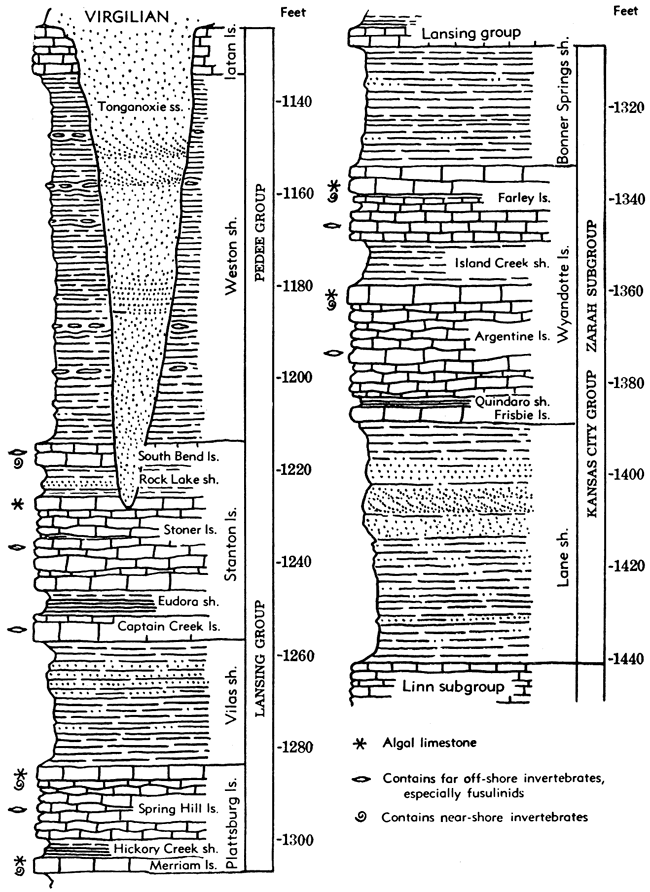
The Wyandotte extends northward into Iowa and Nebraska but southwestward from Kansas City it becomes thinner and the underlying Lane shale thicker. In eastern Anderson County, the Wyandotte is locally absent and in northern Allen County it is found to grade laterally into calcareous ripple-marked sandstone. Where the Wyandotte is missing, there is a virtually indivisible shale section between the Iola and Plattsburg formation and this shale is termed Lane-Bonner Springs shale. As a shale unit, the Zarah portion of the Kansas City group can be followed southward to Montgomery County, nearly but not quite to the Oklahoma line. In southernmost Kansas and northern Oklahoma it is equivalent to lower Ochelata beds.
Lane Shale
The Lane shale (Haworth, 1895, p. 277) includes beds between the top of the Iola limestone and base of the Wyandotte limestone (Figs. 14, 18, 20). It is developed as a distinct unit from the type locality in Franklin County, Kansas, northward, but disappearance of the Wyandotte limestone a short distance south of Lane makes it impossible to recognize the upper boundary of the Lane shale. Accordingly, as has been noted, in this region the Lane is combined with overlying shale as Lane-Bonner Springs shale.
The Lane beds are variable in lithologic character and in thickness. At some places the entire unit consists of dark bluish-gray clayey shale. This type of deposit is mostly found where the formation is thin, that is, about 15 to 35 feet in thickness. In parts of the Kansas City region, the clay shale contains fairly common marine invertebrates, including remarkably preserved complete crinoid crowns (especially Aesiocrinus magnificus) which are displayed in several museums. Where the Lane shale is thick, that is, 50 to 110 feet, most of the shale is sandy and micaceous. The color ranges from light-gray to yellowish-brown or buff. Thin plates and beds of friable sandstone a few inches thick appear, especially near the top. The thick sandy shale contains carbonaceous streaks but coal beds are not observed. Fossils are mostly lacking, but a few land plant remains are found at some outcrops.
The Lane shale is a thin but persistent unit from eastern Miami County, Kansas, northeastward. It has been recognized in northwestern Missouri, southwestern Iowa, and in the Platte Valley section of southeastern Nebraska. The thickness of the shale in Johnson and eastern Miami counties, Kansas, ranges from 16 to 40 feet, the average being about 25 feet. In western Miami and eastern Franklin counties, the thickness increases to about 100 feet. The Lane-Bonner Springs shale is sparsely fossiliferous, dark-bluish, clayey to fine silty shale, and is about 75 feet thick near Iola and about 60 feet thick farther south in Kansas.
Wyandotte Limestone
The Wyandotte limestone (Newell, in Moore, 1932, p. 92) comprises the beds between the Lane and Bonner Springs shales (Figs. 14, 18, 20). It consists predominantly of light-colored limestone but contains two shale members, of which the upper one locally attains a thickness of 20 feet or more. As a whole, the formation is readily traceable on the basis of its physical characters, stratigraphic position, and influence on topography.
The Wyandotte has a maximum thickness of about 60 feet in Johnson and Leavenworth Counties, Kansas, but is thinner to the south. The formation pinches out abruptly southwest of Lane, in Franklin County, and is recognized only locally southward as far as Allen County. It has been traced far northward, however, being identified in southwestern Iowa and along the Platte Valley in Nebraska. The members of the Wyandotte limestone (in upward order) are Frisbie limestone, Quindaro shale, Argentine limestone, Island Creek shale, and Farley limestone.
Frisbie limestone member. The basal Wyandotte member, called the Frisbie limestone (Newell, in Moore, 1932, p. 92) consists of dark-blue or blue-gray dense limestone, which differs from succeeding beds in its massive character and (where typically developed) presence of vertical joints (Figs. 18, 20). The member is not very fossiliferous but commonly shows thin irregular calcite "veinlets" which seem to be of organic origin. Numerous brachiopods, bryozoans, and crinoids have been collected from this limestone in the Kansas City area, however. The thickness of the Frisbie limestone ranges from 1 to 3 feet.
Quindaro shale member. Shale and shaly limestone overlying the Frisbie limestone is defined as the Quindaro shale member (Newell, in Moore, 1932, p. 92) of the Wyandotte limestone (Figs. 18, 20). Locally this shale is black, fissile, and carbonaceous, but more commonly it is yellowish and calcareous and beds of this type grade laterally into shaly limestone which is not sharply separated from limestones above and below. The thickness of the Quindaro shale is only 1 to 2 feet.
Argentine limestone member. Normally, the thickest subdivision of the Wyandotte formation is the Argentine limestone member (Newell, in Moore, 1932, p. 92), which succeeds the Quindaro shale and is overlain by the Island Creek shale, or (where this shale is absent) by the Farley limestone (Figs. 18, 20). The Argentine limestone is light bluish-gray when fresh and weathers creamy-white, grayish-white, or light-buff. The bedding is thin and uneven, many of the layers being distinctly nodular. The rock is mostly very fine-grained but there is much crystalline calcite in the form of very thin irregular (algal?) "veinlets" and small cavity fillings. Sparse gray and brownish chert is somewhat characteristic. In the Kansas and Missouri River valleys the lower part of the rock is shaly and locally comprises alternating thin beds of limestone and shale. Fossils are numerous in most places, the fauna consisting chiefly of brachiopods and bryozoans.
The Argentine limestone is about 30 feet thick at Kansas City and has an average thickness of 20 feet in Johnson and Miami counties, Kansas. This member disappears south of Lane but is persistent northeastward in Missouri. It is identified in Iowa and southeastern Nebraska.
Island Creek shale member. Bluish-greenish clay shale, which overlies the Argentine limestone in many places, belongs to the Island Creek shale member (Newell, in Moore, 1932, p. 92) of the Wyandotte formation (Figs. 18, 20). At the type locality, northwestern Wyandotte County, Kansas, the Island Creek is 43 feet thick, which is nearly the observed maximum. In outcrops not far distant, the shale diminishes to a featheredge. In some exposures, most of the interval between the Argentine and Farley limestones is occupied by fine-grained massive sandstone. The member is nonfossiliferous.
Farley limestone member. A thin limestone lying between the Argentine limestone (formerly believed to be Iola) and the Plattsburg formation (Figs. 18, 20) in Platte County, Missouri, was named Farley by Hinds & Greene (1915, p. 29). Later, it was found that two limestones, lithologically similar to the Farley, occur in this part of the section in the Kansas and Missouri river valleys above Kansas City; collectively they were called Farley (Moore, 1932, p. 92; Newell, 1935, p. 60). Still later studies have shown that in Kansas north of Miami County, an extremely variable assemblage of limestone and shale beds occurs next above the lithologically more persistent Argentine limestone. Many types of limestones are seen, suggesting that more than one cycle of marine deposition may be represented. With little doubt, the type Farley represents only one or two of the limestone elements of this variable unit, but the name may be applied to all. Among the Farley beds thus specified, the most characteristic are oölitic-appearing algal limestone, limestone breccia or conglomerate, and dense mottled pinkish limestone. Cross-bedding is common in both the algal limestone and breccias. Wavy- and thin-bedded mottled limestone, chiefly in the lower part, is somewhat similar to the main body of the underlying Argentine limestone. A thin bed of greenish-gray sandy shale containing a molluscan fauna occurs rather persistently in the approximate middle part of the Farley section. In general, the Farley limestones contain many fossils, especially shells of mollusks. Large nautiloid cephalopods are common at some places. The thickness of the Farley member ranges from a featheredge to about 40 feet.
Bonner Springs Shale
The Bonner Springs shale (Newell, in Moore, 1932, p. 93) includes strata between the Wyandotte formation, below, and the Plattsburg limestone, above (Figs. 18, 20). The formation consists of 10 to 25 feet of gray or buff shale, the sandy lower part of which grades locally into soft sandstone filling channel-like depressions several feet deep carved in underlying strata. These sandy beds contain remains of land plants in some places. The upper part of the shale consists of olive-green clay shale and, near the top, 1.5 feet or less of maroon clay shale, which is persistent in Miami and Johnson counties, Kansas. The maroon shale is commonly overlain by a thin layer of ocher-yellow to greenish, calcareous shale or soft nodular limestone. Locally, as at DeSoto, Johnson County, and one-half mile west of Bonner Springs, Wyandotte County, the Bonner Springs shale is absent, apparently due to nondeposition or perhaps to erosion preceding Plattsburg deposition, for a shell breccia at the base of the latter formation rests directly on the Farley member of the Wyandotte limestone.
The maximum observed thickness of the Bonner Springs shale is about 45 feet. South of the point in east-central Kansas where the Wyandotte beds disappear, the Bonner Springs shale is not separable from the Lane beds and the entire section between the Iola and Plattsburg limestone is designated as Lane-Bonner Springs shale. Thus, it comprises the undifferentiated Zarah subgroup of southern Kansas.
Lansing Group
Definition
As originally defined (Hinds, 1912, p. 7), the name Lansing was applied to strata from the top of the so-called Iola limestone (Frisbie-Argentine of present classification) in the Kansas City area to the top of the Stanton limestone. The overlying shale (Weston) was thought to be a part of the Douglas "shale." The Lansing beds were designated as a formation and divided into members termed (in upward order) Lane shale (now recognized as Island Creek shale, Farley limestone, and Bonner Springs shale), Plattsburg limestone, Vilas shale, and Stanton limestone. When work by Condra (1927), Newell (1935) and others led to subdivision of the Plattsburg and Stanton units into persistent limestone and shale components, which were classed as members, it became necessary to treat Plattsburg, Vilas, and Stanton as formations and to change Lansing formation to Lansing group. Moore (1932) revised the assigned span of the Lansing group by transferring beds below, the Plattsburg to the Kansas City group. Usage of the Kansas Geological Survey in definition of the Lansing group consisting of the Plattsburg, Vilas, and Stanton formations, was accepted by the inter-State conference (Fig. 14).
Distribution and Thickness
The Lansing group is exposed in a belt which trends south-southwestward across Kansas from northern Leavenworth County to western Montgomery County (Fig. 21). The belt is much narrower than that of the Kansas City outcrops on the average, especially in areas where the shale which separates the lower and upper limestone formations is comparatively thin and escarpments made by the latter are close together. The eastern edge of the outcrops is topographically prominent and easily mapped, whereas the western margin is very obscurely marked and difficult to map precisely. The western boundary is drawn along the not-sharply-defined line where the gently inclined smooth plain developed on the uppermost Lansing limestone merges with hilly slopes formed by lower Pedee shales. The hard rocks of the Lansing group make rugged topography wherever the strata are crossed by major streams, for tributaries of these streams cut through the Lansing rocks in deep ravines. Excellent exposures of rocks belonging to the group are seen in Wyandotte, Leavenworth, Johnson, Franklin, Anderson, Woodson, and Wilson Counties, Kansas.
Figure 21. Distribution of outcrops of the Lansing and Pedee groups in Kansas and parts of adjoining States. These groups comprise the uppermost part of the Missourian Series. South of west-central Montgomery County, Kansas, strata equivalent to Lansing and Pedee are classed as belonging to the upper part of the Ochelata group.
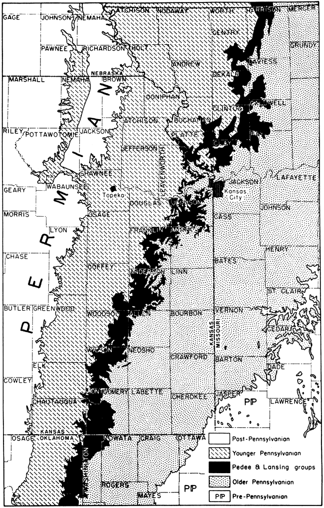
In northwestern Missouri, the Lansing formations are concealed in most places by glacial drift, but nevertheless the outcrop belt is generally expressed in the topography. Outcrops of Lansing strata are identified in Iowa and along the Platte River Valley in Nebraska, but because shales separating the Lansing from lower and higher limestones are thin, and because glacial drift is mostly very thick, there is no Lansing escarpment. Southward from Montgomery County, in southern Kansas, the Lansing is not clearly differentiated because the lower limestone formation disappears and the upper limestones become thin and somewhat discontinuous. The equivalent rocks in Oklahoma are classed as belonging in the upper part of the Ochelata group.
Rocks of the Lansing group seem to lie conformably on uppermost Kansas City beds in most places, but in southern Kansas and northeastern Oklahoma the lower Lansing rests disconformably on underlying rocks, with progressive overlap toward the area of the Chautauqua arch. Physical evidence of this hiatus is seen also near Bonner Springs, Lane, and Greeley, Kansas. It consists of the local absence of pre-Plattsburg beds, irregularities of contact, and local occurrence of conglomerate at the base of the Plattsburg. Slight regional warping of Kansas City and older rocks in the Chautauqua arch area, which does not affect Lansing beds, is associated with absence of lower Lansing deposits.
The thickness of the Lansing group averages about 75 feet, but in parts of southern Kansas it is more than 150 feet.
Lithologic Character
The Plattsburg-to-Stanton division placed in the revised Lansing group is characterized by dominance of limestone and along most of the outcrop the Lansing limestones lie closely together, forming a prominent escarpment which is widely separated from escarpments made by lower and higher limestones. Shales belonging to this group are partly marine and partly nonmarine. The nonmarine shaly deposits, which are quantitatively most important, are silty to sandy and mostly unfossiliferous. Sandstone is a very inconspicuous constituent of the Lansing group.
Cyclic features of Lansing sedimentation are illustrated in Figure 18 and are described briefly in the introductory part of discussion of the Kansas City group.
Classification
Formations belonging to the Lansing group are named, in upward order, Plattsburg limestone, Vilas shale, and Stanton limestone. These units are readily differentiated along the outcrop and are identified at many places in the subsurface area of Lansing distribution. In well records, it is common practice, however, to mark the easily determined top of the Lansing strata and to unite Lansing with underlying Kansas City beds, dominantly limestone, under the designation of Kansas City-Lansing. These rocks are oil-bearing in many parts of central and western Kansas.
Plattsburg Limestone
The Plattsburg limestone (Broadhead, 1866, p. 317), named from outcrops in northwestern Missouri, overlies the Bonner Springs shale and occurs beneath the Vilas shale (Figs. 14, 18, 20). It shows little variation in lithologic and faunal characters and can be recognized without difficulty at most outcrops. The Plattsburg is identified in southeastern Nebraska, and has been traced from south-central Iowa across northwestern Missouri and eastern Kansas to a point near the Oklahoma boundary where it disappears. Marine fossils, especially the brachiopods Enteletes, Marginifera, and Composita, are common in certain zones, and a varied sponge fauna occurs in the Plattsburg throughout much of central and southern Kansas.
The thickness of the formation ranges from less than 5 feet to more than 100 feet, the average being about 20 feet. A noteworthy feature is the considerable variation of thickness in short distances along parts of the outcrop.
The Plattsburg limestone contains two limestone members, Merriam and Spring Hill, and an intervening shale member, Hickory Creek. With varying clearness in different places, these show characters that are typical of certain subdivisions of the typical megacyclothem.
Merriam limestone member. The lowermost member of the Plattsburg limestone, named Merriam limestone (Newell, in Moore, 1932, p. 93), commonly contains three distinct divisions: (1) a lower blocky, drab to light-gray, highly fossiliferous layer, which weathers gray or white; (2) a middle unit consisting of fine-grained dense, vertically jointed bluish limestone; and (3) an upper unit consisting of algal and granular limestone (Figs. 18, 20). The lower limestone contains numerous productids and a few other brachiopods, including locally a zone of Composita at the base. The large flat pelecypod, Myalina ampla, is characteristic of the lower Merriam, as is also the alga Osagia, which commonly occurs in such abundance as to form an appreciable part of the rock. In many places, this part of the Merriam member is oö1itic.
The lower Merriam limestone ranges in thickness from a few inches to about 5 feet. The middle part of the Merriam is a typical homologue of the Paola, Middle Creek, and similar limestones. This bed is mostly poor in fossils, but the upper part contains numerous irregularly disposed cylindrical tubes which are filled with yellowish-brown ferruginous clay. These tubes are interpreted as worm borings. The middle division of the Merriam limestone member is about 1 foot thick. The upper unit ranges from a featheredge to about 8 feet in thickness and is less persistent than the lower two parts. It contains rather abundant nautiloid cephalopods.
Hickory Creek shale member. The middle Plattsburg member is named Hickory Creek shale (Newell, in Moore, 1932, p. 93) from outcrops in Franklin County, Kansas. It ranges in thickness from less than an inch, in a few places, to a maximum of about 40 feet. Where thin, the shale contains a black carbonaceous zone, as is characteristic of the shales overlying limestones like the middle unit of the Merriam (Figs. 18, 20). Where the shale is thick, it is gray or yellowish in color and clayey. Fossils are rare or lacking.
Spring Hill limestone member. The uppermost division of the Plattsburg formation is named Spring Hill limestone (Newell, in Moore, 1932, p. 93). The lower part consists of thin-bedded bluish-gray, fine-grained brittle limestone which bears numerous Enteletes, Marginifera, and, in Nebraska, abundant fusulinids. The upper part contains light-gray oölitic limestone, or granular drab-colored somewhat argillaceous coquinoid limestone. In addition to Osagia and possibly other algal remains, abundant echinoid spines and numerous specimens of a robust Composita are found in the upper part of the Spring Hill limestone (Figs. 18, 20).
The lower unit of the Spring Hill member has an average thickness of about 5 feet and the upper unit about 7 feet, making an average total of about 15 feet. Great variation in thickness, however, characterizes this limestone, for it is observed to range from a featheredge to 50 feet.
Vilas Shale
The Vilas shale (Haworth, 1898, p. 51) is the middle formation of the Lansing group, named from a town in northeastern Wilson County, west of Iola (Figs. 14, 18, 20). The shale is gray to buff, clayey and sandy, and is mostly barren of fossils. Near Kansas River a persistent zone of fine-grained gray, hard, ripple-marked sandstone occurs near the top or in the middle. Farther south, much reddish-brown soft sandstone and sandy shale occurs locally in the Vilas.
Average thickness of the formation in the north is about 15 feet but in southern Kansas thickness increases to 80 feet or more locally. Abrupt variation in thickness is characteristic of the Vilas.
Stanton Limestone
The Stanton limestone (Swallow & Hawn, 1865, p. 6; Newell, 1935, p. 76) overlies the Vilas shale conformably and, except where Virgilian strata directly overlie Stanton limestone, is succeeded conformably by the Weston shale of the Pedee group (Figs. 14, 20, 30). It forms a fairly prominent escarpment from northeastern Kansas to the southern part of the State. The thickness of the formation ranges from about 20 feet to at least 100 feet at a few places in southern Kansas. Along the Kansas and Missouri River Valleys, the Stanton is fairly uniform in character and averages 35 to 40 feet in thickness, but in east-central Kansas and farther south there are great local variations. For example, near Elk City in Montgomery County, the Stanton is approximately 100 feet thick, but 3 miles southward it is only 10 feet thick. Near the Oklahoma-Kansas line it is difficult to trace the Stanton, but in the vicinity of Ramona, south of Bartlesville, Oklahoma, limestone equivalent to the Stanton is thick and readily identified. These beds in Oklahoma are classed as part of the Wann formation (Oakes, 1940, p. 72) (Fig. 14).
The Stanton formation contains five members (in upward order): Captain Creek limestone, Eudora shale, Stoner limestone, Rock Lake shale, and South Bend limestone.
Captain Creek limestone member. The lowest member of the Stanton is called Captain Creek limestone (Newell, 1935, p. 76), from outcrops near Eudora, Douglas County, Kansas. It is readily identified in most sections by its distinctive lithologic character and by its position beneath black fissile shale of the Eudora member (Figs. 20, 30). The limestone is dark-gray or blue, dense, brittle, and hard. It is massive or even-bedded and in most places shows prominent vertical joints. Beautifully preserved specimens of the brachiopod, Enteletes pugnoides, are abundant in the Captain Creek limestone throughout most of northeastern Kansas, and a robust fusulinid, Triticites neglectus, occurs commonly on bedding planes of the member. This dense blue limestone is a typical representative of the cyclothem element previously noted in several limestone formations, occurring next below black platy shales. Such beds are a characteristic feature of Missourian and Virgilian megacyclothems, in which they belong to the second cyclothem of this sequence. At the top of the Captain Creek limestone, as seen at some exposures, a peculiarly brecciated siliceous bed, a few inches thick, bears mottled pink and blue color.
The Captain Creek limestone is identified throughout northern Kansas and northwestern Missouri, and has been recognized in Iowa and in the section of the Platte Valley, southeastern Nebraska.
The thickness of the member is 4.5 to 5.5 feet along Kansas River and most places farther north, but southward it increases to more than 10 feet in parts of Miami County and, according to Newell, 40 feet northwest of Independence, Kansas.
Eudora shale member. The shale overlying the Captain Creek limestone is named the Eudora shale member (Condra, 1930, p. 12) of the Stanton, from excellent exposures near Eudora, on Kansas River east of Lawrence. It is a very constant unit in northeastern Kansas and northwestern Missouri. The lower part consists of black fissile shale or in some places of dark clay shale containing a thin carbonaceous layer (Figs. 20, 30). The upper part is greenish- to bluish-gray in color, and is soft and clayey.
The thickness of the Eudora shale ranges from only 1 foot in some northern outcrops to 50 feet in part of Montgomery County, Kansas. The average thickness is about 5 feet. Megascopic fossils are rare in the Eudora shale of northeastern Kansas, but well-preserved molluscan shells are fairly common in southern Kansas, and in northeastern Oklahoma in equivalent beds.
Stoner limestone member. Light bluish-gray to nearly white limestone which commonly weathers very light-gray or creamy-white overlies the Eudora shale and comprises the Stoner limestone member (Condra, 1930, p. 11) of the Stanton (Figs. 20, 30). Normally, this is the thickest limestone subdivision of the formation. The member is named from outcrops in the Platte Valley of Nebraska. Beds of the Stoner limestone are mostly thin and wavy, with thin shaly partings between the layers; the rock is fine-grained, but in places much crystalline calcite is irregularly distributed.
This member is 11 to 15 feet thick along Kansas River and elsewhere in northeastern Kansas, but in parts of southern Kansas, where the Stanton attains a thickness of 100 feet, the member measures about 50 feet.
The fine-grained, light-colored character, thin wavy bedding, large relative thickness, and stratigraphic position next above black fissile shale, are all typical attributes of a megacyclothem element (representing the third cyclothem of type Shawnee examples). Seemingly, it marks the culminating part of the complexly oscillatory submergence which is inferred to be represented by a megacyclothem. The Stoner limestone is less fossiliferous on the average than most limestone units which are homologous to it. To the north, it contains abundant Triticites of the T. irregularis type.
Rock Lake shale member. Overlying the Stoner limestone is a persistent shale which is classed as the Rock Lake shale member (Condra, 1927, p. 59) of the Stanton limestone (Figs. 20, 30). Like the Stoner, it is named from outcrops in the Platte Valley. The contact at the base of the shale in many places is irregular, suggesting a slight disconformity. Commonly, a thin layer of greenish-gray clay shale is seen in the lower part of the member, but most of the unit consists of reddish-brown to dark-buff sandy shale or soft sandstone. The sandstone is shaly, even-bedded, or massive. A persistent red shale zone occurs in the middle part of the Rock Lake shale in southeastern Nebraska. The thickness of this member ranges from about 1 foot to 15 feet.
The Rock Lake shale contains locally a remarkable assemblage of well-preserved land plants of Permian aspect, including abundant Walchia, mingled with remains of amphibians, fishes, a scorpion, and marine invertebrates (Moore, Elias, & Newell, 1936).
South Bend limestone member. The uppermost member of the Stanton formation is the South Bend limestone (Condra & Bengston, 1915, p. 23) which lies conformably on the Rock Lake shale and conformably beneath the Weston shale (Figs. 20, 30). It is named from a locality in the Platte Valley of Nebraska, where this limestone and associated beds clearly represent a cyclothem having several well-defined phases; this cyclothem is distinct from that to which the Stoner limestone belongs. The most persistent beds of the member consist of dark-gray, fine-grained limestone. The brachiopod Meekella striatocostata and a fusulinid similar to Triticites moorei are the most common fossils.
The thickness of the South Bend limestone in northeastern Kansas is rather constantly about 4 to 5 feet, and in southeastern Nebraska, it is about 10 feet. The member is identified at numerous exposures in northwestern Missouri, but has not been identified definitely in southern Kansas.
Pedee Group
General Description
In the vicinity of the Kansas River, deposits of Virgilian age rest directly on upper beds of the Lansing group, but to the north and south there are post-Lansing strata of variable thickness that belong to the Missourian Series. These rocks are assigned to the Pedee group (Figs. 14, 20). They lie conformably on the Stanton formation and are bounded above by the disconformity that divides Missourian and Virgilian deposits. The lower part of the Pedee group is called Weston shale, and the upper part, which is definitely recognized only north of Kansas River, is named Iatan limestone.
It is probable that along the Missouri River in the vicinity of Iatan and Weston, between Leavenworth and Atchison on the Missouri side, and in some other places where the Iatan limestone is present, some shale of Missourian age may occur above the Iatan. Such shale is assignable to the Pedee group, but no beds in this position are identified definitely. Evidence of the exact position of the Missourian-Virgilian boundary near Iatan and Weston is lacking but inasmuch as the thickness of the zone within which the boundary belongs is only 5 to 20 feet, this uncertainty is not of great importance. Observation of somewhat variable lithologic characters in this zone, its irregular local changes in thickness, and at least in some places, unevenness of the top of the Iatan limestone, indicate that the disconformity here belongs at the top or a few feet above the Iatan. In other areas the Missourian-Virgilian disconformity plainly cuts downward far into the Weston or even well below the top of the Stanton formation, as in the Kansas River Valley.
The Pedee group is about 100 feet thick southeast of St. Joseph, but locally, as throughout much of Platte County, Missouri, and in the Kansas River Valley, Pedee beds are only a few feet thick or they are lacking. In southern Kansas Pedee deposits have a thickness of about 200 feet at some places, as just west of Caney.
Weston Shale
The Weston shale (Keyes, 1899, p. 300) includes the beds between the top of the Stanton limestone and the base of the Iatan limestone (Figs. 14, 20). Where the Iatan is absent, the top of the Weston is marked by the disconformity at the base of the Virgilian Series. Here, the next beds above the Weston may consist of coarse conglomerate, massive or irregularly bedded sandstone, red shale, or sandy brownish and bluish shale belonging to various horizons of the Douglas group.
The Weston shale is a fairly uniform dark bluish to bluish-gray marine clay shale, which in many places is characterized by the presence at several levels of many flattish, elliptical ironstone concretions. Fossils are not very numerous in the shale, but in places thin highly fossiliferous limestone beds in the Weston can be traced for several miles. No coal beds or sandstones have been observed in the Weston of northern Kansas and northwestern Missouri, but toward the south there are some layers of shaly to even-bedded sandstone and much of the shale is silty to fine sandy in texture.
The thickness of the Weston shale ranges from a featheredge to a maximum of about 140 feet. On account of post-Missourian erosion, the thickness of the Weston in near-by sections may be very dissimilar.
Iatan Limestone
The Iatan limestone (Keyes, 1899, p. 300) overlies the Weston shale conformably and is overlain disconformably by the Stranger formation, basal deposits of the Virgilian Series (Figs. 14, 20). The limestone is light bluish-gray or nearly white, both in fresh and weathered exposures, but parts of the Iatan are mottled with brown after prolonged weathering. The bedding is indistinct and somewhat uneven, so that the rock appears rough and shelly but very massive. Large blocks, separated by joint planes, tend to break from the outcrop and creep down steep slopes. The texture of the limestone is very fine and dense, but there are very numerous thin, irregular plates of clear, calcite which are differentially etched by weathering. Numerous nodular fragments of dense limestone are thought to be algal deposits. Brachiopods, bryozoans, crinoid stem fragments, and locally, small corals, are the most common fossils, but fossil remains are not abundant in most places. Fusulinids are numerous at the top of the formation between Weston and Iatan, Missouri, and in the lower half of the Iatan outcrops at St. Joseph. At the latter place the upper bed of the Iatan is a molluscan-algal phase limestone, containing Derbyia, mollusks, and crowded with large Osagia.
The thickness of the Iatan ranges from less than 5 feet to about 22 feet, the maximum being observed a short distance south of Iatan. The formation is extensive in northeastern Kansas and northwestern Missouri, north of Leavenworth and southward at least to the vicinity of Baldwin, in southern Douglas County, Kansas. The limestone which has been called Iatan in country farther south is mostly a lower Virgilian unit, the Haskell, but some limestone outcrops may represent true Iatan. A limestone belonging beneath the post-Missourian disconformity and above the Stanton limestone is observed near Caney in southern Kansas and northern Oklahoma.
Prev Page--Middle Pennsylvanian || Next Page--Upper Pennsylvanian, Virgilian Series
Kansas Geological Survey, Geology
Placed on web Jan. 26, 2009; originally published Nov. 1949.
Comments to webadmin@kgs.ku.edu
The URL for this page is http://www.kgs.ku.edu/Publications/Bulletins/83/07_up.html