![]()
Prev Page--Geologic Formations--Quaternary || Next Page--Ground Water
Geologic History
The geologic history of this area is recorded in the rocks at and beneath the surface and is similar to that of much of central and western Kansas. This area is underlain by 4,000 to 4,500 feet of limestone, sandstone, shale, clay, silt, sand and gravel, and small amounts of salt and gypsum. Much of the geologic history must be inferred from studies of records of deep oil wells, but the details of this history are beyond the scope of this report. The geologic history of the area in Cenozoic time merges into the physiography and much of the more recent geologic history is interpreted from study of the landscape.
Paleozoic Era
Many oil wells have been drilled in McPherson, Harvey, Sedgwick, and Reno counties and much of the early Paleozoic sediments is known from drill cuttings. Drills have penetrated marine limestones and shales of Cambrian, Ordovician, Silurian, Devonian, Mississippian, Pennsylvanian, and Permian age, which indicates that the area was covered by seas during much of the Paleozoic era. The absence of deposits of Silurian and Devonian age in part of this area probably is due to erosion after those sediments were deposited, and indicates that this probably was a land area during parts of the Silurian and Devonian periods. The sedimentary record is broken at intervals, indicating that this was an emergent area for relatively short periods of time, followed by reinvasion by seas and renewed deposition of marine material.
[Note: Silurian and Devonian rocks do not occur in parts of this area.]
In early Permian time marine limestones and shales of considerable thickness were deposited in this area. Rocks of the Leonardian Series indicate a change in the environment of deposition in late Permian time. The Wellington formation is composed of marine deposits, for the most part, and contains considerable amounts of salt and gypsum. The presence of these minerals indicates that the sea in this region became less extensive and that the climate then probably was arid. The Ninnescah shale and Stone Corral dolomite similarly signify the retreat of the Permian sea and the aridity of the late Paleozoic climate.
Mesozoic Era
Deposition of rock-forming materials evidently was terminated by an uplift that brought the region above sea level at the close of the Paleozoic Era. Central Kansas probably stood above sea level through the latter part, if not all, of Triassic time and through Jurassic time, during which there was little or no deposition and probably considerable erosion. No rocks of Triassic or Jurassic age are known in this area. Locally a zone of pebbles and cobbles of source unknown to the authors occurs on the irregular surface of the Permian rocks below the Cretaceous rocks in this area. These pebbles may be residual, in part, or may have been deposited in early or middle Mesozoic time; at least, they are older than the oldest Cretaceous rocks known in Kansas.
Cretaceous Period
The Lower Cretaceous sea transgressed the land areas from Texas northward and first reached central Kansas in middle Comanchean time, for the Cheyenne sandstone present in southern Kansas does not occur in this area. In discussing the origin of the Cretaceous rocks in Kansas, Stanton (1922, p. 263) states: "During a large part of Comanche time the northern shore of the Mexican sea was in northern Texas, or not far beyond it, as evidenced by the nature of the Trinity and Paluxy sands and the northward thinning of all the limestones. In later Comanche time, however, about the beginning of the Washita, a somewhat rapid northward transgression of the sea began, which soon reached southern Kansas and by the close of the Washita had extended as far north as Sauna, in central Kansas. The advance was probably of a halting nature, with possibly slight reversals of movement, so that with shallow waters, low-lying lands, shifting currents, and varying amounts of sediment received, the shoreline sometimes rapidly shifted many miles both north and south and east and west, thus giving alternations of purely marine beds with those that represent swamp or terrestrial conditions."
Stanton notes further (1922, p. 270): "I agree with Twenhofel's suggestion that it is reasonable to regard the Cheyenne, Kiowa, Mentor, and associated rocks as all deposited during one general transgression of the sea, but I would interpret the Dakota as representing merely a halt in that advance rather than a complete retreat of the sea from the Great Plains area."
The above remarks are in accord with the authors' field observations of the stratigraphy and lithology of the Kiowa shale in this area. The Dakota formation occurs west of McPherson County in Ellsworth and Rice counties and probably was deposited in part of the area covered by this report, having been removed by post-Cretaceous erosion. The Upper Cretaceous shales and limestones which occur elsewhere in Kansas are absent in central Kansas and if deposited they have since been removed by erosion. At the close of the Cretaceous period, orogenic movements uplifted the Rocky Mountain area and affected at least part of the rock formations in Kansas.
Cenozoic Era
Tertiary Period
After tilting of the Cretaceous and older rocks at the close of the Mesozoic Era erosion during a long period removed much of the Cretaceous sediments from this area and also much of the Pennsylvanian and Permian sediments east of this area. Erosion was active until late Tertiary time and then the sediments of the Delmore formation were deposited during middle Pliocene. The Delmore formation was laid down by streams eroding the Cretaceous and Permian rocks north and east of the area the materials having been deposited in depressional areas and valleys of southward-flowing streams. Early Tertiary erosion removed overlying rocks and exposed the salt-bearing part of the Wellington formation to solution by ground and surface waters. A depressional area resulted in the eastern part of the area and became progressively deeper as solution and erosion proceeded westward down the dip of the Wellington. This stratigraphic control of erosion determined the direction of the principal late Tertiary streams in this area. The vertebrate fossils of middle Pliocene age found in McPherson County indicate a climate warmer than the present.
Sediments of late Pliocene age have not been recognized in this area and, unless removed by subsequent erosion no deposition occurred here during the closing part of the Pliocene. Elsewhere indications of reduced vigor and load of late Tertiary streams are recorded in the less clastic rocks deposited then. The close of the Tertiary Period in North America was marked especially by uplift of the Pacific Northwest region and additional uplift, of the Sierra Nevada range. The Rocky Mountains and neighboring areas were uplifted to a lesser extent at this time, resulting in rejuvenation and change of existing streams and in the inception of new streams.
Quaternary Period
Pleistocene Epoch
After the physical disturbance at the end of the Tertiary Period there was a gradual climatic change in North America which resulted in the formation of the great ice sheets which distinguish the Pleistocene Epoch. Glaciers did not reach the area covered in this report but erosion and deposition by streams which were fed by meltwater from mountain glaciers are recorded in the unconsolidated deposits of the McPherson formation. The alternating cold and mild climates of the Pleistocene conditioned life in this area and the vertebrate fossils collected from the several formations reflect this climatic variation.
Early in the Pleistocene a stream flowing southwestward entered this area near Lindsborg and continued past McPherson and Moundridge southward west of Wichita. Tributary streams entered the main stream from the northwest, northeast, and east. Remnants of the highest terraces along the Smoky Hill River indicate that a large tributary entered the area from the northwest, occupying nearly the same position as the present river but flowing at a much higher level. The deposits of silt, sand, and gravel of the McPherson formation in the southwestern part of the area were laid down by tributaries flowing southeastward. Sand and gravel, in part cemented, and silt occurring along the eastern margin of the alluvium of the present Arkansas and Little Arkansas rivers in the southeastern part of the area indicate that tributaries flowed southward toward the main channel. A drainage divide now exists immediately east of the area shown on Plate 1, but the divide was at a higher level and was considerably farther east early in the Pleistocene. The finer sediments of the McPherson formation imply that the early Pleistocene streams had a lower gradient than those active in this area later in the epoch.
Volcanic ash was deposited in early McPherson time. As suggested by Landes (1928, p. 19), the original source of the ash must have been volcanic vents southwest of this area--perhaps the Capulin group of volcanoes in northeastern New Mexico.
Toward the close of the first stage of the Pleistocene Epoch recorded in this area the streams which had been active in eroding the McPherson Valley seemingly became overloaded and the silt, in the older part of the McPherson formation was deposited over much of the valley. Solution of soluble material in the Wellington formation continued, but deposition of silt and fine sand by streams at grade characterized early McPherson time. An unconformity of some magnitude occurs between the older deposits of the McPherson formation and the channel deposits of the formation.
The streams were rejuvenated after the period of quiescence following deposition of the early sediments of the McPherson, possibly by some renewed uplift in the mountains, but largely by an increased quantity of water available to the principal stream and tributaries flowing southward through the McPherson Valley. The source of the additional water available to streams at this time may have been the melting of the ice of the mountain glaciers which may have reached their culmination during the period following deposition of the older beds of the McPherson. Continued solution of salt in the Wellington formation caused the stream to migrate westward in this area. The extent of erosion during this period is indicated by the depth of the buried McPherson channel in relation to the surface of the older sediments of the McPherson (Pl. 6). The location of the stream system which carved the McPherson channel has been described above. Terraces along the Smoky Hill River northwest of this area together with test drilling furnish the basis for conclusions regarding the location and magnitude of the streams.
After underloaded streams had completed the erosion described, the streams seemingly became overloaded, because of either a smaller supply of water or an abundance of available detritus and the valleys began to be filled. Some time after this valley filling had been in progress it is believed that the stream flowing southward into the area was captured by headward erosion of an eastward-flowing stream in the vicinity of Salina and the direction of flow was reversed. The tributary stream entering the area from the northwest flowed into this reversed drainageway and was directed northward also. This divergence into a new stream system changed the gradient of the captured streams and downcutting began anew. The junction of the two streams northwest of McPherson became less angular and moved northward, ultimately resulting in the anomalous bend in the present course of the Smoky Hill River between Salina and Marquette. Sharps Creek, while flowing at a level somewhat higher than at present, seems to have occupied a course southeastward from the SE cor. T. 18 S., R. 5 W. at the time the major stream was captured. Later, as the junction of the principal stream and tributary moved northward and cut downward, Sharps Creek was captured and became a part of the new drainage system. A large tributary of the southward-flowing stream through the McPherson Valley entered the area from the northwest and occupied a course nearly the same as the present Arkansas River from Hutchinson to a point east of Mt. Hope where it joined the main stream. After the capture of the master stream farther north, this tributary continued to flow southeastward and is represented by a section of the present Arkansas River.
The sand dunes which occupy part of the area between the Little Arkansas River and the Arkansas River in the west-central part of the mapped area (Pl. 1) have been in the process of formation since early McPherson time. The older dunes probably were beginning to form while the streams depositing the McPherson formation were flowing southward through the area. After the drainage of the master stream was reversed near Lindsborg, the dunes formed across the old channel northwest of Burrton at the place now marked by a topographic saddle. Dune formation has continued and the higher dunes, differentiated on Plate 1, are still active, especially in times of drought. The source of the sand forming the dunes probably was from the south and southwest; at least, the prevailing winds have been from those directions during the period of record. It is noted that prevailing winds may have been from different directions during the Pleistocene.
After the McPherson Valley was abandoned by the southward-flowing stream, the channel began to be filled by the slow movement of soil, silt, and other rock waste down the slope of the valley sides. At high stages the tributary occupying the course of the present Smoky Hill River near Marquette probably overflowed southwestward, depositing silt in the old channel and forming a temporary lake. The winds which deposited the sand in the dunes athwart the old channel undoubtedly carried silt and clay farther northward, depositing part of the material in and along the channel. This material was then transported down the valley sides into the old channel by rills and rivulets following heavy rains. The filling of the McPherson Valley is continuing by these processes today and vestiges of the old drainageway are manifest in the linear series of lakes and depressional areas which occur from a point northwest of McPherson southwestward toward Colwich.
Recent Development of Land Forms
Sand dunes.--The higher sand dunes shown on Plate 1 have been developed by the southerly and southwesterly winds prevailing at present. The effectiveness of the wind action was more pronounced during periods of drought, and the recent activity of the dunes during the decade from 1930 to 1940 is noteworthy. The winds sweeping across the Arkansas Valley plain transport sand northward adding new material, at the same time reworking sand deposited in the dunes during earlier periods. The dunes are encroaching on the channel of the Little Arkansas River north and northeast of Burrton. The subdued older sand dunes which occur locally on the Arkansas Valley plain are not active at present; a soil zone sufficient to sustain cultivated crops has developed on these dunes and they are becoming less prominent landforms as farming continues.
Remnants of what probably once were sand dunes occur in a belt trending northeastward between Goessel and Canton (Pl. 14). As noted above, these dunes are believed to have developed from partly cemented sandstones in the Kiowa shale formerly cropping out in the same area now occupied by the faint dune remnants. Admixture of silt and clay and the development of a thick soil zone have stabilized these vestigial landforms.
Some recently developed small sand dunes, not shown on Plate 1, occur near Wichita and elsewhere along the Arkansas and Little Arkansas rivers. These dunes, generally occupying comparatively small areas, have been formed by winds sweeping the sandy floodplains of the streams at times of prolonged low stage. Many of these recent dunes are in locations vulnerable to flood waters and are only transient landforms.
Sinkholes.--The undrained depressions in the land surface which occur in a linear area from a point north of Conway to Colwich (Pl. 1) have been developed in recent times and many of them are still subsiding. The small sinkhole shown in Plate 20A and B developed about 1929. Between 1929 and September 1937, when the photograph was taken, the submerged bridge had been raised three times by McPherson County engineers. The largest sink, located in T. 19 S., R. 4 W., is known as Big Basin and occupies an area of about 4 square miles. This area has been artificially drained but the outline of the sink is plainly marked on the aerial photograph shown on Plate 21. Lake Inman, the largest natural lake in Kansas, occupies an undrained depression covering about 160 acres. Lake Inman and smaller sinks and incipient sinks in the area around it are shown on Plate 22.
Plate 20--Sink holes in McPherson and Harvey counties. A, B, Aerial and surface photographs of a sink hole at the SW cor. sec. 22, T. 21 S., R. 4 W. C, Aerial photograph of sink hole in secs. 9 and 16, T. 24 S., R. 3 W. Arrows point north and are about 0.5 mile long. A and C, U.S. Department of Agriculture photographs; B, by S. W. Lohman.
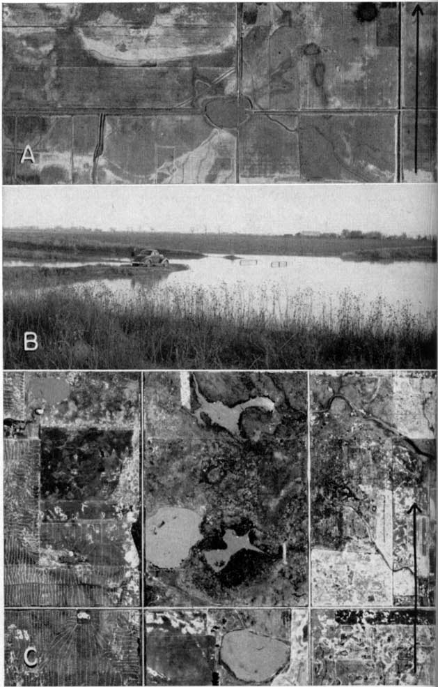
Plate 21--Composite aerial photograph of Big Basin and vicinity. many small sink holes and small areas of incipient sinking also are shown. Arrow points north, is about 0.5 mile long, and is located in the E sec. 14, T. 19 S., R. 4 W. U.S. Department of Agriculture photograph.
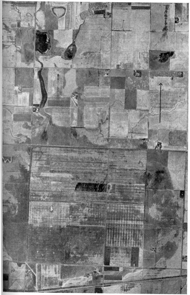
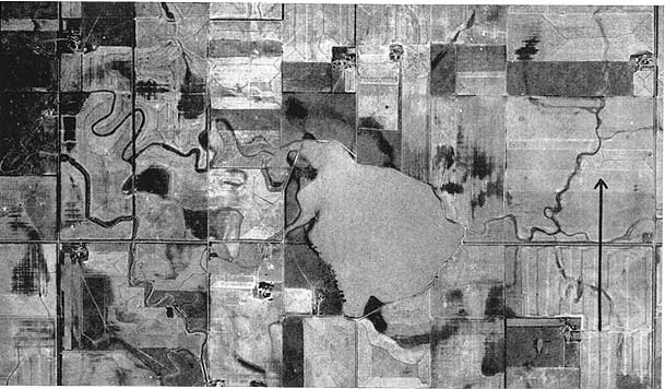
Plate 22--Aerial photograph of Lake Inman and vicinity. The small dark areas denote incipient sinking. The arrow points north and is about 0.5 mile long. U.S. Department of Agriculture photograph.
The ultimate physical cause of the sinkholes has been and is the removal of salt by solution from the underlying Wellington formation. Bass (1926a) has shown that the salt beds in the Wellington extend into this area and that the line of sinkholes in McPherson, Harvey, and Sedgwick counties practically coincides with the present eastern margin of the salt beds. Although it is evident that sinking has occurred recently at many places, some filling of the sinkholes has taken place concurrently. In the latter part of April 1944, after a period of excessive precipitation, many of the sinks were filled with water laden with silt and clay derived from higher parts of the area. More than 4 square miles in Big Basin and much of the area southward toward Lake Inman and Buhler were inundated by muddy water. The slow draining of the floodwater allowed much of the suspended silt and clay to be deposited in the low areas. At other times, following heavy rains, soil is washed into the depressions from areas in the immediate proximity, smoothing the edges of the sinkholes and contributing to their filling. As subsidence ceases the sinkholes will become filled and no longer will be prominent physiographic features.
Stream terraces.--Terraces bordering streams are records of erosion by streams as they shifted course laterally while flowing at a level higher than at present. Stream terraces are preserved as topographic features owing to a change in quantity of water or load carried by streams or because of a change in gradient.
Terraces are present along the Arkansas, Little Arkansas, and Smoky Hill rivers and to a minor extent along smaller streams in this area. The margin of the alluvium along the Arkansas and Little Arkansas rivers is marked by a topographic break in most places. In some places smaller terrace remnants occur along the floodplains of the streams; such terrace remnants along the Smoky Hill River are shown on Plate 1. Terraces along the Arkansas River are shown on Plate 23, and those along the Smoky Hill River are shown on Plate 24. Remnants of higher terraces along the Smoky Hill River are shown on Plate 1 and are part of the McPherson formation. High terraces along the Smoky Hill become more nearly continuous westward in Ellsworth and Russell counties (Frye, Leonard, and Hibbard, 1943). Lateral erosion by streams is aided by other erosional processes, especially along some of the smaller tributaries. That slumping of stream banks may be a contributing factor to terrace development is illustrated by features shown on Plate 11C. Here the surface of the soft sandy Kiowa shale has become saturated following a season of excessive precipitation, and slumping has occurred along the steep bank. If these slump blocks were to remain as shown and the vegetal regimen were re-established, terracettes or "sheep trails" would result. If, however, the small stream whose present channel is at the base of the bluff carries away part of the material and further slumping occurs, the valley wall will recede and a small terrace comparable to the one shown in the foreground will be developed.
Plate 23--Composite aerial photograph of showing a part of Arkansas river and vicinity. Note sink holes, flood scars, scarcity of trees along the river, and extreme flatness of the terrace surface. The small stream enters the river in the NW sec. 20, T. 25 S., R. 2 W. Small arrows point to terrace edge. Large arrow points north and is about 0.5 mile long. U.S. Department of Agriculture photographs.
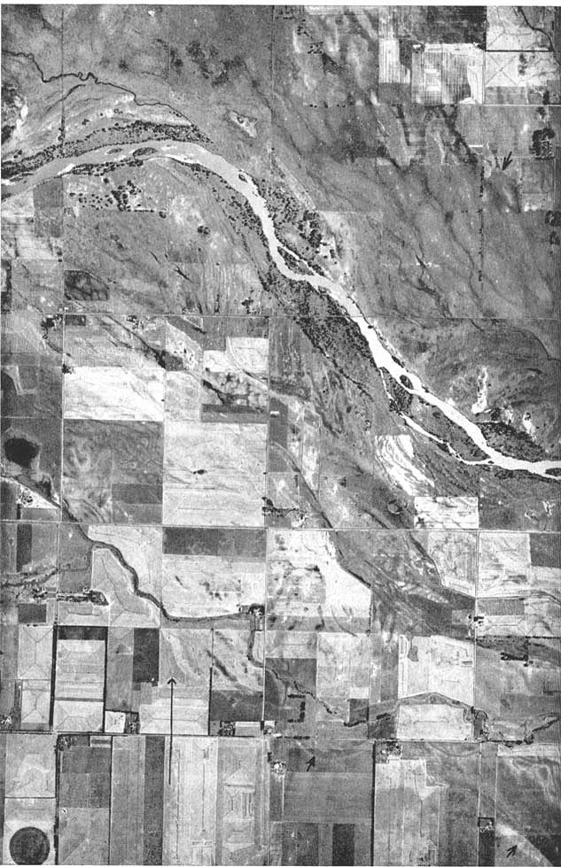
Plate 24--Composite aerial photograph showing a part of the Smoky Hill River valley in T. 17 S., R. 5 W. compare with Arkansas river (Pl. 23). note oxbow lake, left center, and imminent cutoff, right center. Small arrows point to terrace borders. Large arrow [in lower center] points north and is about [1 mile long]. U.S. Department of Agriculture photograph.
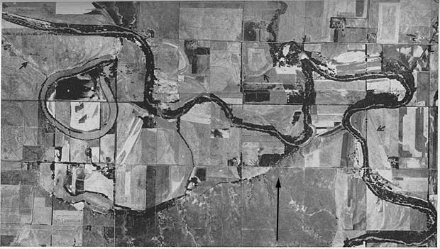
Major streams.--The three major streams in the area, Arkansas, Smoky Hill, and Ninnescah rivers, all may be classed as consequent or interrupted - consequent streams with reference to the present cycle of erosion. The Arkansas River is at present an aggrading stream in this area, as indicated by the braided pattern of the sand bars and the evidence of recent deposition by the section of the river shown on Plate 23. That the Smoky Hill River recently has been eroding its valley laterally and more recently has begun to cut downward entrenching its valley is apparent from the abandoned meanders and low terraces shown on Plate 24. The Ninnescah River seems to be a younger stream with a steeper gradient than either the Arkansas or Smoky Hill, and little or no alluvium occurs in its valley; the Ninnescah shale is exposed along the Ninnescah River throughout its course in this area. As soon as rock waste becomes available to the river it is carried away; hence the valley floor and gently sloping valley sides are nearly devoid of alluvium.
Prev Page--Geologic Formations--Quaternary || Next Page--Ground Water
Kansas Geological Survey, South-central Kansas
Comments to webadmin@kgs.ku.edu
Web version April 2005. Original publication date July 1949.
URL=http://www.kgs.ku.edu/Publications/Bulletins/79/08_georecent.html