![]()
Prev Page--Geography || Next Page--Geologic Formations--Cretaceous
Geologic Formations and Their Water-bearing Properties
In addition to the following discussion of the geologic formations in this area, a considerable amount of data concerning them is included elsewhere in this report. Logs of 354 test holes and wells are grouped at the end of the report and the locations of the test holes and wells for which logs are given are shown on Plate 7. Mechanical analyses of the unconsolidated deposits are included in the section on the physical properties of the water-bearing materials. Records of typical wells tapping the formations are given in Table 37. Analyses of water derived from the several formations are given in Table 13.
Summary of Stratigraphy
[Note: Since the completion of field work and preparation of the manuscript for this report, further studies by the State Geological Survey have resulted in modification of the stratigraphic conclusions and classification; therefore the text of this bulletin differs from the accepted nomenclature of the Kansas Survey. The pressing need for public release of the valuable hydrologic data contained in the report, however, has prompted us to publish it as approved by the United States Geological Survey. -- R. C. Moore.]
The rock formations that crop out in the parts of Harvey, McPherson, Marion, Reno, and Sedgwick counties included in this report are of sedimentary origin and range in age from Permian to Recent. The areas of outcrop of the various formations are shown on Plate 1. The principal water-bearing formations are the sandstones of the Kiowa shale, the Delmore formation, McPherson formation, and alluvium of the Arkansas, Little Arkansas, and Smoky Hill River valleys. The stratigraphic relationships of these and other formations are shown on the geologic profiles (Pl. 6). The character and ground-water supply of the geologic formations in this area are described briefly in the generalized section in Table 6, and in more detail under geologic formations and their water-bearing properties.
***Plate 6 in pocket***
***Plate 7 in pocket***
Table 6.--Generalized section of the geologic formations in parts of Harvey, McPherson, Marion, Sedgwick, and Reno counties.
| System | Series | Formation | Thickness (feet) | Physical character | Water supply |
|---|---|---|---|---|---|
| Quaternary | Recent | Alluvium unconformable on older formations |
0-75± | Silt, clay, and cross-bedded coarse-grained sand and gravel containing silt and clay. | Yields large to very large supplies of relatively hard water to wells in the Arkansas and Little Arkansas valleys. Smaller quantities are obtainable from the Smoky Hill Valley. |
| Younger dune sand unconformable on older dune sand |
0-50± | Fine- to medium-grained eolian quartz sand. These younger, higher dunes are subject to shifting and blowout and are devoid of vegetation. | The higher dunes are above the water table in most places but constitute a valuable intake area. | ||
| Recent and Pleistocene | Older dune sand unconformable on older formations |
0-100± | Fine- to medium-grained, rounded eolian quartz sand, cross-bedded. Several cycles of deposition set off by soil zones. In general these dunes have a cover of vegetation and are subdued in form. | Yields small quantities of soft water to domestic and stock wells. Water contains considerable iron. Forms an important catchment area for rainfall. | |
| Pleistocene | McPherson formation unconformable on older formations |
0 - 260 | Buff to brown silt, clay, sand, and gravel. Channel deposits composed of coarse-grained sand and gravel. Contains volcanic ash. | Yields large to very large supplies of moderately hard to hard water, especially from channel deposits, to municipal, industrial, and farm wells. A few contact springs occur at base. | |
| Tertiary | Pliocene | Delmore formation unconformable on older formations |
0-75 | Gray to buff silt, clay, and carbonate, fine- to medium-grained sand, small amount of gravel. Material largely derived from Cretaceous and Permian rocks in and near the area of outcrop. | Yields small supplies of relatively hard water to stock and domestic wells. |
| Cretaceous | Comanchean* | Kiowa shale unconformable on older formations |
0-120 | Dark-gray to black, gypsiferous shale; gray to buff, sandy shale; soft, cross-bedded sandstone; hard, limonitic sandstone; "quartzite"; and thin fossiliferous limestones. | Yields small supplies of hard water to farm and stock wells, and to small springs. |
| Permian | Leonardian* | Stone Corral dolomite | 0-8 | Gray, cellular, thin-bedded dolomite on outcrop in McPherson County. Contains anhydrite and gypsum in subsurface westward. | Yields no water to wells in this area. |
| Ninnescah shale | 0-275 | Soft to hard, brick-red shale. Contains some thin beds of gray and green shale, thin argillaceous limestone and gypsum. | Yields meager supplies of highly mineralized water to farm wells. | ||
| Wellington formation | 550± | Soft, gray, calcareous shale containing gypsum, anhydrite, salt, and thin beds of argillaceous limestone. | Yields meager supplies of highly mineralized water to farm wells from weathered surface zones and crevices in unweathered beds of shale and limestone. | ||
| *Classification of the State Geological Survey of Kansas. | |||||
The geologic formations in this part of Kansas were first mapped by C. S. Prosser and J. W. Beede. They were described and the unconsolidated deposits were named the McPherson Equus beds by Haworth and Beede in 1897 (also described by Beede, 1898). On the geologic map of Kansas (Moore and Landes, 1937), a large part of the sand dune area and the alluvium along the Arkansas, Little Arkansas, and Smoky Hill rivers were distinguished from the McPherson formation.
Early in the course of the present investigation, it was deemed advisable to re-map the geology of the area; therefore a reconnaissance geologic map was prepared. In a previous publication Lohman and Frye (1940) (1) restricted the McPherson formation (the Equus beds of early reports) to include only the fluvial deposits of Pleistocene age, (2) assigned a new name, the "Emma Creek formation," to the other beds included in the McPherson formation that they thought were of Pliocene age, and (3) mapped the "loess" as a separate unit. In the present report (1) the name "Emma Creek" is abandoned because the beds at the type locality of the formation are now determined to be Pleistocene and are now included in the McPherson, (2) other beds outside the type locality which were assigned to the Emma Creek and whose age has been verified as Pliocene are now given a new name, the Delmore formation (see text), and (3) much of the loess of Lohman and Frye (1940) is included in the McPherson (see text discussion). Further discussion of changes in mapping and in definition of stratigraphic units is included below.
Permian System
Wellington formation
Character and thickness.--The lithologic character of the beds included in the Wellington formation has been described by Bass (1929, p. 99-103), Ver Wiebe (1937), and Norton (1939, p. 1758-1766). The part of the Wellington that crops out in the area shown on Plate 1 consists dominantly of soft calcareous gray and bluish-gray shale containing several thin beds of argillaceous limestone and gypsum. Some beds of maroon and green shale occur near the top of the formation. Beds of gypsum in the Wellington, characterized by local deformation, crop out along Gypsum Creek near its junction with Smoky Hill River and elsewhere (Pl. 8C), and thick beds of rock salt are mined from the Wellington in Reno and Rice counties. Although the salt is not exposed in this area, it is known to underlie the western part (Bass, 1926a). Thin impure limestones of the Canton limestone member of the Wellington crop out in the eastern part of the mapped area. Descriptions of parts of the Wellington formation penetrated in test holes are given in the logs of test holes and wells. The Milan limestone member, which marks the top of the Wellington in southern Kansas, was not recognized near Lindsborg where the upper contact was drawn at the line or zone of color change from predominantly gray shale to red shale.
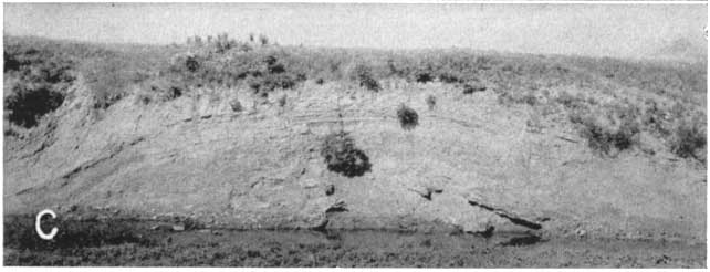
Plate 8C--Gray shale and gypsum in the Wellington formation in NE sec. 3, T. 27 S., R. 1 E.; gypsum at water's edge. Small structure caused by solution. Photograph by C. C. Williams.
The exposed part of the Wellington formation is about 150 to 200 feet thick in this area. Thicknesses as great as 550 feet have been recorded in oil and gas wells.
Distribution and surface form.--The Wellington formation forms the bedrock floor under more than half of this area and as shown on Plate 1, the formation crops out in the eastern and northeastern parts of the area. At Wichita and for about 15 miles north from that city the Wellington crops out along the low bluff that forms the east wall of the Arkansas Valley. In places, as at Wichita, this outcrop band is very narrow and discontinuous and is mantled by the overlying Pleistocene deposits. The soft shales and evaporites of this formation yield on erosion a gently rounded and rolling topography. Northeast of Newton thin limestones cause small "breaks" locally along drainage ways.
Age and correlation.--The term Wellington was introduced as a stratigraphic name by Cragin (1896, p. 16-18). The original definition placed the base of the formation at the top of the "Geuda salt" (within the Wellington formation as now defined) and the top was placed at the base of the Harper sandstone. Later, Bass (1929, p. 99-103) redefined the Wellington including in it rocks occupying the stratigraphic interval between the Herington limestone below and the "Red Beds" above. Norton (1939, p. 1758-1766) summarized the history of the classification of the Wellington formation and, in defining the Ninnescah shale, restricted the Wellington to the interval between the Herington limestone below and the Ninnescah shale above. This definition is the one in use currently. Present classification by the State Geological Survey of Kansas places the Wellington formation at the base of the Sumner group, lowermost group of the Leonardian Series in Kansas.
Water supply.--The Wellington formation yields small quantities of water to wells in the area southeast of Lindsborg, near Roxbury, northeast and southwest of Newton, and east and northeast of Wichita. Some wells in neighboring areas derive water from both the Wellington and McPherson formations. No large supplies of water are available from the Wellington owing to the physical character of the rocks comprising it, but some domestic and stock wells are supplied with very hard water from the shallow weathered zone at the top of the shale and from deeper crevices in the shale and thin limestone beds. Most wells yield enough water in wet years for domestic and stock use, but in dry years many wells fail.
The high mineral content of the water in the Wellington formation is shown graphically on Figure 29. Samples of water collected from the Wellington contained dissolved solids ranging from 1,114 to 2,044 parts per million, total hardness ranging from 640 to 1,302 parts per million, and chloride ranging from 79 to 677 parts per million. Most of the hardness in water from the Wellington formation is noncarbonate, or permanent, hardness.
Ninnescah shale
Character and thickness.--The Ninnescah shale, as the name implies, is predominantly a shale unit throughout its occurrence in Kansas. It conformably overlies the Wellington formation. It is composed largely of brick-red shale but contains some beds of green shale and thin argillaceous limestone near the base, and a rather persistent impure limestone about 5 feet thick near the middle of the formation. Thin beds of light-gray and red sandstone composed of very fine to medium grains occur in the upper part of the Ninnescah. Gypsum occurs in thin cross-cutting and intersecting veins, having been deposited secondarily in the red and green shale.
A small local occurrence of barite in the Ninnescah was observed along the west bank of a ravine near the NW cor. SE sec. 3, T. 19 S., R. 5 W., in McPherson County. The barite occurs filling small spheroidal cavities in light-tan to buff soft siltstone. The barite is generally soft owing to weathering but in some cavities it is hard and unweathered. The barite, though weathered, displays fibrous crystalline form, and masses of the crystals are arranged in conical, stellate, and other forms. The siltstone containing the barite is a few feet thick and is a local facies of the red shale seen elsewhere along the ravine.
The Ninnescah shale forms the bedrock below unconsolidated materials in the western and southwestern part of the area. The Ninnescah shale attains a maximum thickness of about 275 feet in the area of outcrop. Norton (1939, p. 1767-1774) has described the character and thickness of the Ninnescah shale in detail.
Distribution and surface form.--As shown on Plate 1, the Ninnescah shale crops out in the northwestern, west-central, and southwestern part of this area. Good exposures of parts of the Ninnescah may be seen in the northwestern part of the area especially in T. 17 and 18 S., R. 5 W. where erosion by small streams has produced the greatly dissected topography shown on Plate 9. In the southwestern part of the area along tributaries to the Ninnescah River, from which the formation was named, good exposures and characteristic topographic expression of parts of the Ninnescah shale may be observed (Pl. 10).
Plate 9--Aerial photograph showing topographic expression of the Kiowa shale and the Ninnescah shale in secs. 32 and 33, T. 17 S., R. 5 W. and in secs. 4 and 5, T. 18 S., R. 5 W. Sandstone containing "Mentor" fossils caps the bluffs. The white line marks the contact between the formations. The small arrow points to the Natural Corral locality of Twenhofel. The large arrow points north and is about 0.5 mile long. U.S. Department of Agriculture photograph.
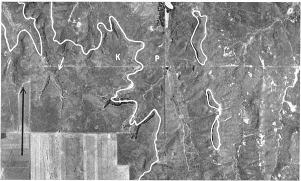
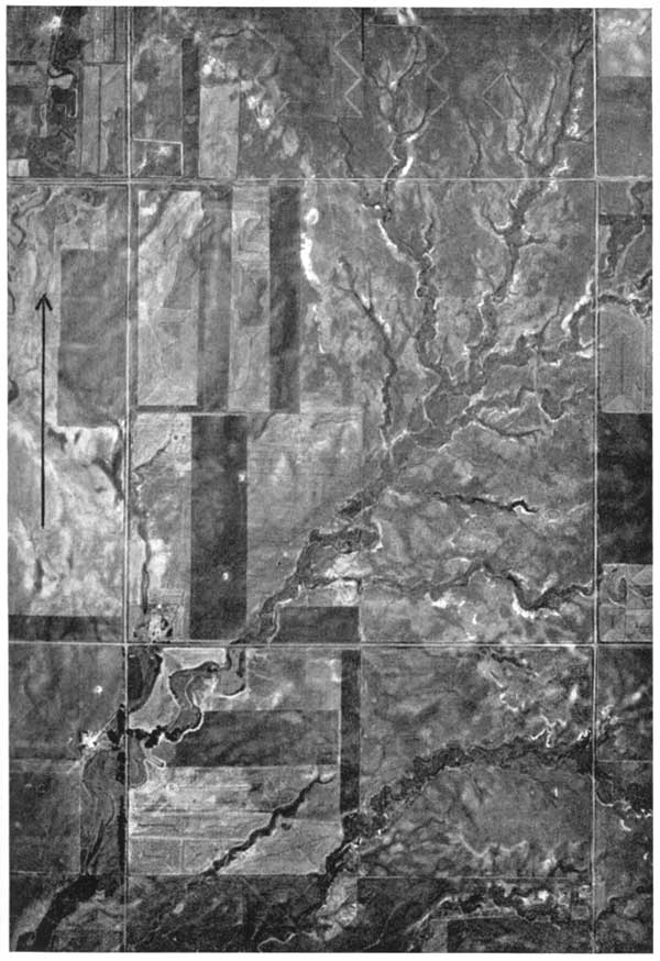
Plate 10--Aerial photograph showing the topographic expression of the Ninnescah shale in the area of outcrop. The square mile in center is sec. 16, T. 25 S., R. 5 W. The arrow points north and is about 0.5 mile long. U.S. Department of Agriculture photograph.
Norton (1939, p. 1767) states: "The [Ninnescah shale] is predominantly a shale throughout most of its occurrence in Kansas, and, because of its excellent exposures on both forks of the Ninnescah River in south-central Reno and north-central Kingman Counties, is here named the Ninnescah shale. . . . At the outcrop, it is 425 feet thick near the Oklahoma line, thinning to 280 feet 50 miles farther north. Though composed largely of red shales, this formation has a minor amount of gray shale beds and thin, impure, limestone beds, and beds of calcareous sandstone and sand, which maintain their lithologic character in a wide area and have been found useful in mapping the structure of south-central Kansas."
In the west-central part of this area, west of a line from Buhler to Conway, the Ninnescah is exposed only in a few localities along the eastern margin of the outcrop area and in small stream valleys south and southwest of Conway, south and southeast of Windom, and southwest of Inman. Unconsolidated materials consisting for the most part of tan to brown silt underlie an area comprising most of the southern half of T. 20 S., the northeastern part of T. 21 S., R. 5 W., and the northwestern part of T. 21 S., R. 4 W. This material is 39 feet thick at test hole 126, west of Inman, but is locally very thin and is composed of reworked windblown silt and slope-wash materials, products of the weathering of the Ninnescah shale nearby. Paucity of exposures precluded showing these deposits on the geologic map.
Age and correlation.--As described by Norton (1939, p. 1,767-1,774) the Ninnescah shale is the basal formation of the Salt Fork division, Cimarron Series. The State Geological Survey of Kansas presently classifies the Ninnescah as the middle formation of the Sumner group, Leonardian Series.
Water supply.--The Ninnescah shale yields water to wells in the west-central and southwestern parts of the area, and is very much like the Wellington formation in its water-bearing properties. Small supplies of very hard water may be derived from wells penetrating the weathered zone at the top of the shale, the thin sandstones at depth, or crevices in the shale and in the thin limestones. Few data concerning water supplies from the Ninnescah were collected, but many stock wells that yield small quantities of water from the shale were observed in T. 25 and 26 S., R. 5 W., and in T. 26 S., R. 4 W. At several of these wells salts were precipitated along the courses regularly taken by water overflowing from stock tanks. As shown on Figure 29, water from the Ninnescah is highly mineralized and is very hard. In the two samples collected from this formation, dissolved solids were 2,217 and 2,616 parts per million, total hardness 1,882 and 1,308 parts per million, and noncarbonate hardness 1,512 and 1,166 parts per million. Gypsum in the Ninnescah, as in the Wellington formation, causes most of the hardness in the water.
Stone Corral dolomite
The Stone Corral dolomite was described in detail by Norton in 1939 (p. 1,774-1,781). The type locality of the Stone Corral dolomite is in sec. 11, T. 20 S., R. 6 W., 2 miles west of the area covered by this report, where it conformably overlies the Ninnescah shale. At the type locality the Stone Corral consists of a massive porous dolomite about 6 feet thick, which forms a prominent scarp for several miles along the west side of the Little Arkansas River valley. This formation becomes thicker in the subsurface westward, where it is composed mostly of anhydrite. The porous nature of the dolomite at the outcrops results from solution of the gypsum and anhydrite. The Stone Corral crops out in sec. 31, T. 19 S., R. 5 W., and in sec. 6, T. 20 S., R. 5 W. (Pl. 1). The topographic expression is not so pronounced in McPherson County as at the type locality in Rice County. The Stone Corral dolomite is classified by the State Geological Survey of Kansas as the upper formation of the Sumner group, Leonardian Series. The Stone Corral yields no water to wells in this area.
Prev Page--Geography || Next Page--Geologic Formations--Cretaceous
Kansas Geological Survey, South-central Kansas
Comments to webadmin@kgs.ku.edu
Web version April 2005. Original publication date July 1949.
URL=http://www.kgs.ku.edu/Publications/Bulletins/79/05_geoperm.html