![]()
Prev Page--Abstract || Next Page--Geography
Introduction
Location and Size of the Area
That part of south-central Kansas considered in this report includes all of McPherson County, all of Harvey County except the eastern tier of three townships, 13 townships in north-central and northwestern Sedgwick County, the western tier of five townships in Marion County, and the easternmost two tiers of 10 townships in Reno County. The area embraces a total of 65 townships or about 2,340 square miles. The location of the area within the state is shown in Figure 1.
Figure 1--Area covered by this report and other areas in Kansas for which cooperative ground-water reports have been published or are in preparation.
Purpose and Need of the Investigation
The area embraced by this report includes the principal area of outcrop of the important Pleistocene water-bearing formation--the McPherson formation (the Equus beds of early reports), which covers a broad area between the Smoky Hill and Arkansas River valleys. The area also includes large segments of these two valleys, which are underlain by alluvium and bordering areas underlain by Permian, Cretaceous and Tertiary deposits. In 1897 attention was focused upon the McPherson formation as a productive source of ground water by Haworth and Beede. It has long been utilized as a source of public-water supply by the cities of McPherson, Galva, Canton, Inman, Buhler, Moundridge, Halstead, and Newton, and prior to this investigation it had also been regarded as a possible source of supply for the City of Wichita. The discovery and development of several large oil fields in the area presented a hazard to the McPherson formation and associated water-bearing formations as a source of public water supply, for, owing to improper methods of disposal, a large quantity of brine produced with the oil eventually found its way into the underground reservoirs.
These and other problems made it necessary to acquire a better understanding of the hydrology and geology of the area and led to the beginning of an investigation in the area in July 1937 by the United States Geological Survey in cooperation with the State Geological Survey of Kansas and the Division of Sanitation of the Kansas State Board of Health.
The investigation was made under the general administration of R. C. Moore and K. K. Landes, State Geologists, Earnest Boyce, Director and Chief Engineer of the Division of Sanitation of the Kansas State Board of Health, and O. E. Meinzer, geologist in charge of the Division of Ground Water of the Federal Geological Survey. During the first year the investigation was under the immediate supervision of the late D. G. Thompson, senior geologist of the Federal Survey; thereafter it was under the immediate supervision of S. W. Lohman, Federal geologist in charge of ground-water investigations in Kansas through June 1945.
History and Methods of Investigation
1937.--After preliminary conferences with cooperating state officials, D. G. Thompson began a reconnaissance of the area in July 1937 and early in August was joined by S. W. Lohman. Thompson was called away on other work in September and for the remainder of the field season the work was carried on by Lohman, assisted part of the time by James I. Nelson. During the first field season an inventory of most of the public water supplies in the area and of many domestic, stock, and industrial wells and a few irrigation wells was made, samples of water for chemical analysis or chloride determination were collected from municipal and representative domestic and industrial wells, a 19-day pumping test was run on well 608 and a network of observation wells was laid out. In December 1937, periodic measurement of the observation wells in the area was begun by G. H. Von Rein.
1938.--The investigation was greatly enlarged and altered in scope during the summer of 1938, when the City of Wichita also began financial cooperation with the Federal and State Geological Surveys and the State Board of Health, in order to determine whether a sufficient quantity of soft, freshwater could be obtained within an economic distance to supply the needs of the city and to replace the then existing supply of hard, brackish water.
Nineteen cable-tool test holes (Pl. 2B) were put down in the Arkansas River valley by the city, under the supervision of the Geological Survey, in order to determine the thickness and character of the water-bearing beds and the quality of the water. During the drilling, samples of material were collected and logs of the formations penetrated were prepared by John C. Frye, Bruce F. Latta, and Fred T. Holden. Mechanical analyses and determinations of permeability of the cuttings were made by Frye and Von Rein. By the use of pneumatic packers (Pl. 3), samples of water were obtained from each water-bearing stratum. From one to three 1 1/4-inch screened well points attached to 1 1/4-inch pipes were left in each hole to serve as observation wells. About 60 driven wells were put down by Von Rein assisted by two city employees (Pl. 4A) in part to aid in the construction of the water-table contour map (Pl. 1), but mainly to study both the lateral and vertical migrations of oil-field brines. Instrumental levels were run to all test holes and to many water wells by Ray S. Delamater, instrument man, and James S. Tandy, rodman. Additional wells were inventoried and sampled by Latta and Delamater. This and other work led to the conclusion that the quantity of fresh and relatively soft water required by the City of Wichita was obtainable from an area underlain by unconsolidated deposits south and west of Halstead, about 22 miles northwest from Wichita.
***Plate 1 in pocket***
Plate 2A--Test hole being drilled in McPherson County by hydraulic-rotary rig owned and operated by State Geological Survey. Photograph by S. W. Lohman.
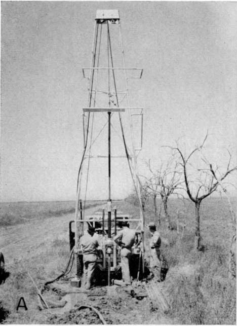
Plate 2B--Setting casing in cable-tool test hole drilled for City of Wichita. Photograph by S. W. Lohman.
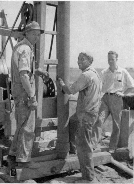
Plate 3--Pneumatic packers used in obtaining water samples from cable-tool test holes drilled for City of Wichita. After packer and screened well point (below) are lowered into place in the test hole, compressed air expands the rubber cylinder tightly against the walls of the hole thus preventing water standing in the hole from entering the pump pipe. Photographs by S. W. Lohman.
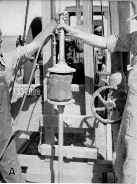
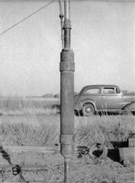
Plate 4A--Driving wells for use in tracing migration of oil-field brines that have seeped in to ground-water reservoir. Photograph by S. W. Lohman.
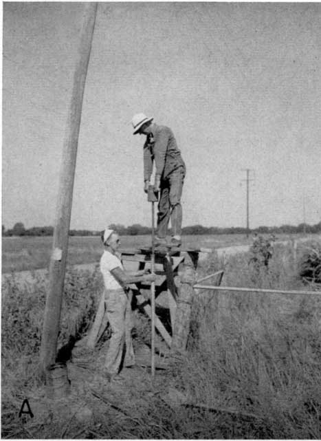
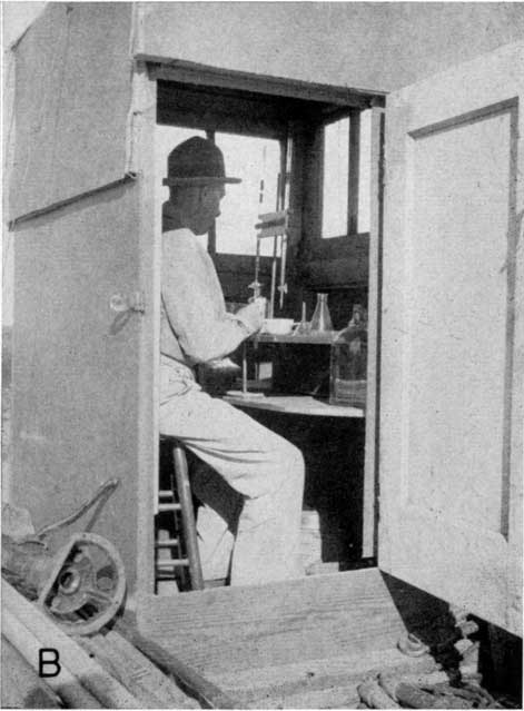
Plate 4B--Portable laboratory mounted on truck for determining chloride content of water samples pumped from driven test wells. Photograph by S. W. Lohman.
1939.--In the winter of 1939, 40 hydraulic rotary test holes were put down under the supervision of Black and Veatch, consulting engineers, for the City of Wichita in order to select the sites for the permanent water-supply wells, and a contract was let by the city to the Layne-Western Company for the construction of the 25 supply wells. During this time John C. Frye completed a reconnaissance of the geology of the area and prepared a preliminary geologic map. Additional wells were inventoried and additional levels were run.
In the summer of 1939, 40 additional test holes (Pl. 2A) were drilled in the area by Ellis D. Gordon, Perry McNally, and Fred T. Holden, using a hydraulic-rotary test drill owned and operated by the State Geological Survey.
1940.--Prior to September 1940, when the new Wichita well field, which was partly financed by the Federal Public Works Administration, was put into operation, the observation-well program was considerably intensified in the well-field area in order to provide the basic data necessary to later make a quantitative study of the well-field area by comparison of water-level contour maps made just before pumping began and at quarterly intervals thereafter. A preliminary report which gave a resume of the geology and hydrology of the area was issued (Lohman and Frye, 1940).
1941-42.--In the summer of 1941, Charles C. Williams was assigned to begin study of the water-level and pumpage data from the Wichita well-field area; however, this work was interrupted in the fall of 1941.
1943.--In the summer of 1943, Williams extended the geologic mapping to include the southwestern part of the area, obtained additional data on the public-water supplies, collected auger samples from the zone of water-level fluctuations at several of the observation wells in the Wichita well-field area for determination of specific yield, and laid out sites for additional test holes. Thirty-six additional test holes were put down in 1943 by O. S. Fent, Mil Klingaman, and Glen Shanteau using the portable hydraulic-rotary rig of the State Geological Survey.
1944-45.--Additional geologic work was done by Williams in 1944, using a new base map at a scale of one inch to the mile prepared from aerial mosaics and supplemented in the field by large-scale aerial photographs. Williams was assisted for about a month by Claude W. Hibbard, formerly Curator of Vertebrate Paleontology of the Museum of Natural History, University of Kansas, and was visited in the field several times by S. W. Lohman and J. C. Frye. Results of the geologic mapping are shown on Plate 1. Hibbard collected many additional vertebrate fossils from the area and prepared a paper on the vertebrate paleontology (Hibbard, 1948). In the fall of 1944, 31 additional test holes were put down by Fent and Klingaman, and in the spring of 1945 Fent and Klingaman assisted by Clifford Dennis drilled 35 more test holes. All the drill cuttings from these test holes and those drilled earlier were examined by Williams using a binocular microscope.
In the summer of 1944 C. K. Bayne inventoried additional wells in the southwestern and northeastern parts of the area and he and R. L. Miles ran instrumental levels to these wells and to the test holes. The locations of the wells visited during the course of the investigation are shown on Plate 5, together with the depth to water level below land surface in the several parts of the area.
***Plate 5 in pocket***
Preparation of report.--Final drafting of the maps and illustrations was done by Robert White, G. Riemer, and W. W. Wilson. Original plans for preparation of the text were interrupted by transfer of personnel. Most of the text, therefore, was prepared by Williams, who wrote all of the sections except the abstract, introduction, the section on saltwater intrusion, and the section on public-water supplies, which were written by Lohman. The base map for Plates 1, 5, 7, and 29 was prepared by Williams at a scale of one inch equals a mile from several sources: the roads and other cultural features were taken from base maps of the State Highway Department or from the new 7 1/2-minute topographic maps of the Wichita area, supplemented by field checks and use of large-scale aerial photographs; the drainage was taken from aerial index mosaics of the Department of Agriculture. The geologic map (Pl. 1) was compiled by Williams from field mapping by Williams, Frye, and Hibbard. Part of the geologic mapping by Williams, particularly in the northern part of the area, was done on large-scale aerial photographs.
The 229 analyses of water given in Table 13, and the many additional chloride determinations (Pl. 29), were made mainly by Robert H. Hess, former chemist, in the Water and Sewage Laboratory of the State Board of Health, but in part by E. O. Holmes, Selma Gottlieb, and H. A. Stoltenberg, chemists in the same laboratory, and in part by Margaret D. Foster and W. M. Noble, chemists in the laboratory of the U.S. Geological Survey at Washington.
Previous Geologic and Hydrologic Work
Permian rocks.--The early history of geologic investigations of the upper Permian rocks in Kansas and the stratigraphy of the Permian formations in the area covered by this report were discussed by Prosser in 1897. The lithologic character and stratigraphy of the Permian rocks were described by Moore (1920), Bass (1929), Ver Wiebe (1937), and Norton (1939).
Cretaceous rocks.--Cragin (1895) described the fossiliferous sandstones and shales of Cretaceous age in this area and applied the name Mentor formation to them. Prosser (1897) reviewed the history of geologic study of Lower Cretaceous rocks in Kansas and assigned the rocks of this area to the Comanchean Series. Twenhofel (1924) described the geology and invertebrate paleontology of the Comanchean and "Dakota" formations of central and southern Kansas. Plummer and Romary (1942) described and classified the pre-Greenhorn Cretaceous beds of central Kansas. Latta (1946) reviewed the history of nomenclature and described the Comanchean stratigraphy of southern and central Kansas.
Pleistocene deposits.--The Pleistocene age of unconsolidated stream-deposited silt, sand and gravel, and volcanic ash (Udden, 1891; Harnley, 1895) in central Kansas was established half a century ago by vertebrate fossils (Cope, 1889, 1895; Udden, 1891; Lindahl, 1892; Williston, 1897). These deposits, referred to as the "Sheridan beds" (Scott, 1897, pp. 532-533) or the "Equus beds," were named the McPherson Equus beds and described in some detail by Haworth and Beede in 1897 (pp. 285-296; Beede, 1898). Additional vertebrate fossils have been collected from this area and described (Deere, 1908; Hay, 1917, 1924, p. 48; Nininger, 1928; Harnly, 1934; Mohler, 1938; Frye and Hibbard, 1941; Hibbard, 1948). Very little geologic work was done in the area after .the work of Haworth and Beede until ground-water investigations were started cooperatively by the State and Federal Geological Surveys in 1937. Preliminary results of this cooperative work have been published (Frye, 1939; Lohman and Frye, 1940; Moore, 1940; Frye and Hibbard, 1941).
Hydrologic studies.--In 1897 Haworth and Beede briefly discussed the occurrence of ground water in McPherson and Harvey counties. The quality and availability of water in Harvey, Marion, McPherson, Reno, and Sedgwick counties were studied and reported on by Parker (1911). In 1913, Haworth described the well waters in Kansas and included in his report a brief description of the Arkansas River and a discussion of ground water in the McPherson-Newton area. In 1914, O. E. Meinzer prepared a preliminary report on ground water for irrigation in the vicinity of Wichita. Preliminary results of cooperative ground-water studies begun in 1937 by the State and Federal Geological Surveys have been published (Lohman and Frye, 1940; Moore, 1940). A report (Lohman, 1942) on the availability of ground-water supplies for national defense industries in south-central Kansas includes a brief description of the ground-water resources of this area. The ground-water conditions in the vicinity of Hutchinson were studied by Williams (1946). A paper was published in 1947 summarizing the methods used in estimating the ground-water supply in the Wichita well-field area (Williams and Lohman, 1947). An observation-well program was begun in 1937 and records of the observation wells in this area have been published by the U.S. Geological Survey in the series of Water Supply Papers on water levels and artesian pressures in the United States (Meinzer and Wenzel, 1938, 1939, 1940, 1942, 1943, 1944, and 1946).
Cooperative investigations of the intrusion of saltwater in this area were made by the U.S. Bureau of Mines and the Kansas State Board of Health in 1934-35 (Wilhelm and Schmidt, 1935; Wilhelm, Thorne, and Pryor, 1936; and Jones, 1938).
Unpublished geologic and engineering reports on the ground-water conditions in this area have been prepared by R. C. Moore, State Geological Survey of Kansas, and by engineers of the City of Wichita, Wichita Water Company, and the Kansas Gas and Electric Company.
Acknowledgments
The writers are indebted to the many well owners, well drillers, city water superintendents, and others in the area who so willingly supplied information concerning water wells. Special acknowledgment is given the late D. G. Thompson of the Federal Geological Survey for planning the initial phases of the investigation; to the district geologists of several oil companies who contributed information from core records on the depth to bedrock; to E. D. St. John, of the Kansas Gas and Electric Company, for permission to run a pumping test on well 608 at the company's Ripley Station; to O. H. Penny and Harry Boyd-Snee, Wichita representatives of the Laughlin-Simmons Company, for many elevations of section corners; to the following officials of the City of Wichita--Burt C. Wells and Alfred MacDonald, former city managers, the late P. L. Brockway, former city engineer and director of service, M. E. Rogers, former superintendent and engineer in charge of the Water Supply Division, Department of Service, and Robert H. Hess, former chemist and present superintendent and chemist in charge, for their splendid cooperation and assistance; to C. H. Kelley, former superintendent, and Robert Meeker, assistant superintendent, respectively, of the Wichita Water Company, for information on wells of the company and assistance in making the investigation; to R. O. Joslyn, president, L. M. Heckman, vice president, and Darwin Soder, Wichita representative, respectively, of the Layne-Western Company, for logs and records of many wells put down by their company; to Ray E. Lawrence, member of the consulting engineering firm of Black and Veatch, for records and logs of test holes and the new Wichita supply wells and other data; to A. W. Heffling, consulting engineer, for information on public water supplies; to Guy Hall, former McPherson county engineer, for information on fossil localities and outcrops of "quartzite" in McPherson County; to Ogden S. Jones, geologist in charge of the Oil Field Section and Robert Mitchell, former geologist of the Oil Field Section, both of the Division of Sanitation of the State Board of Health, and to Ludwig Schmidt and C. J. Wilhelm, U.S. Bureau of Mines, for information on saltwater intrusion in the area; to A. B. Leonard, Department of Zoology, University of Kansas, for determining the age of invertebrate fossils collected in the area; and to all others who aided in the field or in the preparation of the report. The writers are especially indebted to Claude W. Hibbard, formerly Curator of Vertebrate Paleontology, Museum of Natural History, for his assistance in the field and for preparing his paper on the vertebrate paleontology of this area, to the several field assistants listed above under "History and methods of investigation" for their able work in helping compile the field data; and to C. E. Jacob, C. V. Theis, and V. C. Fishel of the U.S. Geological Survey, for helpful advice and criticism of the material comprising the section on "Potential perennial yield of the Wichita well-field area."
The manuscript for this report, in addition to review by several members of the State and Federal Geological Survey staffs, has been read by George S. Knapp, Chief Engineer, and Robert Smrha, Assistant Chief Engineer of the Division of Water Resources, Kansas State Board of Agriculture; by Paul D. Haney, Director and Chief Engineer, and by Ogden S. Jones, Geologist, of the Division of Sanitation, Kansas State Board of Health.
Prev Page--Abstract || Next Page--Geography
Kansas Geological Survey, South-central Kansas
Comments to webadmin@kgs.ku.edu
Web version April 2005. Original publication date July 1949.
URL=http://www.kgs.ku.edu/Publications/Bulletins/79/03_intro.html