Kansas Geological Survey, Bulletin 70, Part 3, originally published in 1947
Originally published in 1947 as Kansas Geological Survey Bulletin 70, Part 3. This is, in general, the original text as published. The information has not been updated.
The texture and composition of widespread loess deposits in central and northern Kansas are described. The discovery of buried soils in uplands of these areas provides basis for correlating loesses of the central part of the State with those in northern Kansas and in Nebraska. The loess deposits are classed as belonging to the Sanborn formation, originally defined in northwesternmost Kansas, inasmuch as they correspond to the type section of the Sanborn in lithologic character and stratigraphic span. Subdivisions of the Sanborn formation are correlated with units in Nebraska and Iowa and are here designated the Loveland silt member (Loveland soil at the top), the Peoria silt member (Brady soil at the top), and the Bignell silt member (surface soil at the top). Names are not proposed for the channel facies of the silt members.
This report is an outgrowth of a field conference in central Kansas May 3 to 9, 1947, which was arranged for the purpose of examining previously described loess localities and making preliminary study of an extensive area in which Pleistocene loess had not been recognized. Attempts were made to establish the identity of eolian deposits that blanket the extensive upland plains, to correlate these deposits with named units in Nebraska and elsewhere in Kansas, and to establish the relationship of the loess sheets to the earlier Pleistocene channel fillings.
During the conference it became evident that there was urgent need for descriptive differentiation of the several loess sheets and their associated soils, particularly in the area where they had not been previously noted, and for establishment of a usable nomenclature.
Appreciation and thanks are expressed to the various members of the field conference party for many pertinent comments and suggestions. Responsibility for errors or inaccuracies of observation or interpretation, however, is our own. The conference party consisted of the following: from the United States Department of Agriculture, James Thorp, principal soil scientist and regional soils inspector, W. I. Watkins, soil scientist, and Paul Brown, assistant soil scientist; from the United States Geological Survey, A. R. Leonard, ground-water geologist; from the University of Ghent, Belgium, Rene Tavernier, professor of geography, an investigator of periglacial geology; from the University of Kansas, H. T. U. Smith of the Department of Geology; and John C. Frye and O. S. Fent of the State Geological Survey.
Our thanks are expressed to Ada Swineford for making the mechanical analyses given in Table 1, and to Russell Runnels for the chemical analyses given in Table 2. Subsurface data used in the preparation of figures and for general information over central Kansas were obtained from logs of test holes drilled by the ground-water division of the Geological Survey. The manuscript was improved by the helpful criticism of Raymond C. Moore, James Thorp, and E. C. Reed.
Loess in the central Kansas region north of the Arkansas River has previously been described in the "Equus beds" area, particularly in McPherson County (Frye, 1939; Lohman and Frye, 1940), Cloud and Republic counties (Wing, 1930, p. 15), and Mitchell and Osborne counties (Landes, 1930, p. 14). In a reconnaissance report on Pleistocene deposits of north-central Kansas, Hibbard, Frye, and Leonard (1944) have reported that loess constitutes much of the Sanborn formation in Jewell, Smith, Phillips, Norton, Decatur, Rawlins, Rooks, Trego, and Sheridan counties. The extent of the loess has been mapped only in the "Equus beds" area and in no previous report has the loess been differentiated by a definite stratigraphic name. Vertebrate and invertebrate faunas from both above and below an extensive soil in the Sanborn formation of north-central Kansas have been listed (Hibbard, Frye, and Leonard, 1944).
The loess in each of these areas has been considered to be of late Pleistocene age, but age equivalence among the several areas was not determined, nor has more than one age of loess at a single locality been recognized except westward from Jewell County adjacent to the Nebraska line. Loess was thought to cap the Permian and Cretaceous upland plain in McPherson County along the Rice County line for a distance of about 10 miles both north and south of Conway, to lap over the rim of the filled McPherson channel, and to overlie the Pleistocene fill of stream-deposited gravel, sand, silt, and volcanic ash. Eastward from the filled valley, the loess blanket thins toward the east to a featheredge along the Marion County line. In Cloud and Republic counties, loess was described as an extensive upland blanket attaining a maximum thickness of 30 to 40 feet, and in Mitchell and Osborne counties it was thought to occur as a thin discontinuous upland blanket.
Westward from Jewell County, a part of the Sanborn formation has been described as gray-yellow loess having a maximum thickness of more than 30 feet. This loess lies on a prominent soil (Loveland) that belongs within the Citellus zone of Nebraska classification. This soil was developed on a thin section of reddish loess or upon water-laid silt and sand. Hibbard, Frye, and Leonard (1944) did not recognize the soil farther south, and therefore thought that correlations with the Nebraska section could not be extended generally over central Kansas.
Extensive sheets of eolian loess upon the uplands in Nebraska have been recognized for many years. Lugn (1935) described these deposits and their geographic extent in the state and correlated the two most extensive loess sheets with the Loveland and Peorian deposits of Iowa, utilizing a well-developed extensive soil at the top of the Loveland as a stratigraphic datum. Later, Schultz and Stout (1945) applied the name Bignell to patchy loess deposits above the thin Brady soil (Schultz and Stout, in press) developed in the upper part of the Peorian of earlier classification. Recently (Condra, Reed, and Gordon, 1947) the correlation of these deposits has been reviewed and substantiated throughout Nebraska by regional subsurface data. Condra, Reed, and Gordon (1947, pp. 25-26) describe the Loveland formation of Nebraska as follows.
The valley phase of the Loveland consists of stratified silts and clays with some laminae of very fine sand with two or more zones of small to large calcareous concretions. It is generally light gray to buff in the lower and middle parts of the formation crrading to pinkish brown in the upper part. This phase grades upslope into the massive loess of the upland phase.
The upland phase of the Loveland formation typically is considerably thinner than the valley phase. It consists of massive loess which mantles the pre-Loveland surface and it is pinkish brown to reddish through its entire thickness.
The colluvial or slope phase of the formation consists of a poorly sorted silty to sandy, occasionally pebbly clay which is pinkish brown to reddish in color and its occurrence is limited to the steeper sideslopes of the pre-Loveland valleys. It is easily confused with highly weathered till because of its poor sorting and because till boulders are occasionally incorporated in it, having been rolled or washed down the steep slopes from the till. However, it rests unconformably on the till or is separated from it by a lag-concentrate gravel layer (upland phase of the Crete formation).
. . . The formation is capped by a persistent old soil in exposures extending intermittently from Illinois to west central Nebraska and into Missouri, Kansas, and northeastern Colorado. The old soil has been called the Sangamon soil in Illinois but in Nebraska and Iowa it is known as the Loveland soil. The Loveland soil is thickest and best preserved where the formation has little relief as on channel fill and in level uplands.
Concerning the Peorian loess, they state, in part (p. 31):
A relatively dry cycle followed the withdrawal of the Iowan ice sheet from Iowa, South Dakota, and Minnesota, and Peorian loess of middle to late Wisconsin age was deposited to variable thickness and widely on the Loveland loess in Nebraska and other areas, where it had not been removed by erosion, and on exposed areas of Todd Valley sand, the Citellus zone, and older formations. However, the term Peorian, as now used, represents the time interval between the Iowan and Mankato substages in Iowa and should not be applied formationally where this interval includes both till and loess substages, as in Illinois and parts of South Dakota. Nor is it possible to subdivide the Peorian substages in Nebraska very satisfactorily because the Tazewell, Cary and Mankato tills are absent here and deposits of their age are represented by alluvial and eolian deposits in the large valleys and by nearly continuous loess deposition in the Loess Plain and Loess Hill regions of the state where the lower boundary of this loess (Peorian) is the Loveland soil and the upper boundary is the present day soil. However, there are places in the uplands of the state where the Peorian shows zonal features that can be used in local stratigraphic correlation, but they are too variable for regional correlation.
And concerning the Bignell (p. 33):
The Bignell loess is in part re-worked Peorian. It was blown from flood plains and valley sides and deposited on terraces and on uplands bordering the Platte, Republican, Elkhorn, Missouri and other valleys. The type locality is south of Bignell, Nebraska. The thickness of this loess is variable, and its age at most places probably is Mankatoan to Recent.
Loess of one or more ages blankets the uplands, gentle-valley slopes, and high terrace levels over much of central Kansas. It is the prevalent surficial material in northern Kansas from the Missouri Valley to the Colorado line. A thin veneer of loess occurs also immediately below the surface of much of southwestern Kansas. Thin discontinuous deposits of loess have been observed resting on the Lower Permian and Pennsylvanian bedrock at a few localities in east-central and southeastern Kansas, and in the south-central region materials identifiable as loess have not been recognized over large areas. The extensive tracts of dune sands and relatively coarse-textured alluvial sediments of south-central Kansas may be genetically related to the loess of other areas.
The loess mantle of central Kansas ranges in thickness from 100 feet to a feather edge, so thin that it is entirely included within the profile of the present soil. The average thickness is not determinable but it is commonly 5 to 30 feet, and over some of the upland areas where the loess forms a nearly continuous blanket it may not exceed 20 feet. The presence of loess has been unsuspected in some areas because, contrary to popular belief, it commonly forms gentle slopes. It gives rise to a deep rich soil that supports an extensive agriculture. The present surface soils of many upland areas give no indication of the underlying bedrock throughout a region underlain by formations ranging from Permian redbeds and Cretaceous sandstones to chalks and noncaleareous shales. We judge that loess is the parent material of the present soils over at least one-third of Kansas.
The texture and chemical composition of the central Kansas loess are typical of similar deposits elsewhere. Size-grade analyses of samples collected from surface outcrops and auger holes have been made under the supervision of Ada Swineford and are reported in Table 1. This table also shows analyses of loess from other areas in Kansas previously reported.
Swineford has made the following statement concerning the texture of the material (personal communication):
Pipette analyses show the size frequency distributions of the silt samples (nos. 1 to 8 in Table 1) to be similar to those of loess collected by Frye in northwestern Kansas (Swineford and Frye, 1945; Frye, 1945), in that 50 to 75 percent falls within the diameter range 0.01 to 0.05 mm. They differ, however, in having a slightly larger percentage of particles of clay size, and the samples from southernmost localities contain a larger quantity of fine sand. The clay may have been developed by soil processes, and the fine sand suggests proximity to a local source area.
The deposit represented by sample no. 9, lying on a high terrace in the lee of the Hutchinson dune tract, may represent material transitional between the dune sand to the south and southwest and loess to the north. The size-frequency distribution in itself does not indicate whether the material is primarily a wind or water deposit, or a result of alternate action of wind and water.
Table 1--Mechanical analyses of acid insoluble fraction of samples of Sanborn silt from central Kansas. (Analyses by Ada Swineford and Catharine Ruggles.)
| Sample no. |
Location | Stratigraphic position | Size distribution (percent by weight), in mm | ||||||||||
|---|---|---|---|---|---|---|---|---|---|---|---|---|---|
| 1-0.5 | 0.5-.25 | .25-.125 | .125-.0625 | .0625-.0312 | .0312-.0156 | .0156-.0078 | .0078-.0039 | .0039-.00195 | .00195-.00098 | .00098 | |||
| 1 | SE cor. sec. 20, T. 9 S., R. 6 W., Mitchell County. | Auger sample, 0.5 foot above Loveland soil, 4.5 feet below surface. | 0.2 | 0.2 | 0.3 | 31.0 | 32.4 | 12.0 | 8.5 | 6.5 | 3.4 | 5.5 | |
| 2 | SE cor. sec. 20, T. 9 S., R. 6 W., Mitchell County. | Auger sample, B horizon buried Loveland soil, 8 feet below surface. Loveland silt member. | 0.1 | 0.1 | 0.1 | 0.4 | 42.4 | 20.9 | 13.8 | 8.2 | 5.0 | 3.4 | 5.5 |
| 3 | NE sec. 29, T. 8 S., R. 6 W., Mitchell County. | Auger sample, 4 feet above Loveland soil, below surface soil. | 0.7 | 0.1 | 0.2 | 18.8 | 42.4 | 17.7 | 7.8 | 6.0 | 2.7 | 3.7 | |
| 4 | E of Cen. sec. 5, T. 7 S., R. 3 W., Cloud County. | Road cut, Peoria silt member, 10 feet below surface, above Greenhorn limestone. | 0.4 | 0.1 | 0.2 | 26.4 | 43.9 | 13.5 | 2.1 | 8.0 | 2.1 | 3.4 | |
| 5 | SW cor. sec. 24, T. 19 S., R. 6 W., Rice County. | Road cut, Loveland silt member, 4.5 feet below surface. | 0.7 | 1.9 | 3.2 | 25.8 | 38.4 | 10.8 | 5.2 | 6.2 | 2.3 | 5.6 | |
| 6 | SW sec. 7, T. 18 S., R. 7 W., Rice County. | Road cut, Peoria silt member, 1 foot above Loveland soil. | 0.1 | 0.2 | 8.6 | 47.6 | 21.5 | 6.9 | 4.9 | 3.9 | 1.9 | 4.6 | |
| 7 | NW NW sec. 22, T. 20 S., R. 7 W., Rice County. | Road cut, Loveland (?) silt member, 3 feet below surface. | 1.4 | 3.4 | 6.0 | 46.3 | 19.0 | 10.5 | 4.3 | 3.8 | 1.7 | 3.6 | |
| 8 | NW NW sec. 22, T. 20 S., R. 7 W., Rice County. | Auger sample, Loveland (?) silt member, 7 feet below surface. | 0.3 | 2.8 | 6.9 | 8.1 | 36.1 | 14.9 | 12.6 | 6.2 | 5.1 | 2.5 | 4.6 |
| 9 | NW SW sec. 17, T. 22 S., R. 4 W., Reno County. | R. R. cut, post-Loveland, 4 feet below surface. | 1.2 | 17.2 | 29.0 | 13.8 | 22.4 | 3.2 | 2.5 | 4.2 | 1.9 | 1.5 | 3.1 |
| Selected analyses of Sanborn silts previously reported. | |||||||||||||
| A | NW sec. 8, T. 8 S., R. 35 W., Thomas County. | R. R. Cut, Peoria silt member, 30 feet below surface. | 0.3 | 5.0 | 64.2 | 18.5 | 4.2 | 3.1 | 1.2 | 1.0 | 2.4 | ||
| B | NW sec. 8, T. 8 S., R. 35 W., Thomas County. | R. R. Cut, Peoria silt member, 10 feet below surface. | 0.1 | 0.4 | 0.7 | 4.1 | 46.3 | 30.6 | 6.8 | 4.7 | 1.8 | 1.2 | 3.3 |
| C | SW cor. sec. 4, T. 1 S., R. 41 W., Cheyenne County. | Road cut, Peoria silt member. | 0.1 | 3.4 | 67.2 | 16.7 | 4.0 | 1.8 | 1.1 | 0.8 | 4.8 | ||
| D | SW cor. sec. 28, T. 3 S., R. 36 W., Rawlins County. | Road cut, Peoria silt member, 25 feet above base of loess. | 0.1 | 3.3 | 55.9 | 22.4 | 6.9 | 3.0 | 1.7 | 1.1 | 5.5 | ||
| A nd B: Frye, 1945, p. 72. C and D: Swineford and Frye, 1945, p. 250. | |||||||||||||
Chemical analyses of the same samples reported in Table 1 have been made by Russell Runnels in the laboratories of the State Geological Survey and are shown in Table 2.
Table 2--Chemical analyses of silt samples from central Kansas. (Sample numbers correspond to those in Table 1.) Analyses by Russell Runnels in the laboratories of the State Geological Survey.
| 1 | 2 | 3 | 4 | 5 | 6 | 7 | 8 | 9 | |
|---|---|---|---|---|---|---|---|---|---|
| SiO2 | 68.81 | 70.29 | 70.44 | 71.37 | 70.03 | 72.77 | 68.58 | 65.38 | 68.61 |
| R2O3 | 18.20 | 18.61 | 18.93 | 18.92 | 15.88 | 14.42 | 16.65 | 18.52 | 19.72 |
| CaO | 2.67 | 0.79 | 1.15 | 1.27 | 2.56 | 1.82 | 2.19 | 3.94 | 0.96 |
| Loss on ignition* | 4.42 | 3.95 | 3.04 | 3.00 | 4.16 | 4.27 | 3.86 | 5.24 | 3.64 |
| Total | 94.10 | 93.64 | 93.56 | 94.56 | 92.63 | 93.28 | 91.29 | 93.09 | 92.93 |
| Undetermined difference (Na, K, MgO, SO3) | 5.9 | 6.36 | 6.44 | 5.44 | 7.37 | 6.72 | 8.71 | 6.91 | 7.07 |
| Calculated CaCO3 | 4.77 | 1.41 | 2.05 | 2.27 | 4.57 | 3.25 | 3.91 | 7.04 | 1.71 |
| Solubility in HCI (determined independently) | 14.7 | 8.5 | 21.2 | 13.6 | 12.1 | 12.2 | 13.2 | 15.1 | 16.2 |
| *Determined after drying to 140°C. | |||||||||
Strongly conflicting opinions have been expressed concerning the origin of deposits classed as loess. The term has been used by some workers in a genetic sense and by others in a lithologic sense. For the past 50 years (Haworth, 1897, p. 276) the extensive upland silt deposits of northwestern Kansas have been thought to be of eolian origin and this conclusion has been further substantiated by recent work (Swineford and Frye, 1945; Frye, 1945a, pp. 86-88). Elias (1931, p. 180), in describing the loess of Wallace and adjacent counties in Kansas, has recognized (1) eolian deposits capping the uplands, (2) deposits on the slopes which he thought were made during Recent time by reworking of material on the divides, and (3) silts in the valley bottoms that he interpreted as representing a reworking by streams. He applied the term loess, nevertheless, to all three phases of the deposit, and thus used it to designate lithology rather than origin. The same relationship of colluvial slopes to upland loess and alluvium has been described in Thomas County (Frye, 1945, pp. 74-78) and elsewhere in western Kansas (Frye, 1946).
The loess sheets that mantle extensive upland areas are deposits of silt moved by wind from more or less distant sources to approximately their present position. Initial depressions on the depositional surface are judged to have held water for considerable time during unusually wet seasons and to have received sediment moved by sheet wash from adjacent slightly higher surfaces. This conclusion is substantiated by lenticular concentrations of snail shells which in some instances are those of aquatic species (A. B. Leonard, personal communication). The floors of these initial depressions may have been sufficiently modified by soil processes to develop a more resistant near-surface layer and so produce reversals of the microtopography of the loess plain during subsequent periods of wind scour.
The physiographic setting at the times of major loess accumulation constitutes the key to the interpretation of the several facies of the sediments. The major loess sheets were seemingly deposited subsequent to intervals of erosion, contemporaneous with and immediately following the placement of alluvial fillings in the major valleys. Eolian action spread silts over broad uplands, lee slopes in sharply dissected areas, and high terrace surfaces. Some slopes not blanketed with eolian material were covered with colluvial or sheet wash deposits derived both from the eolian silts of the uplands or high terrace levels and the bedrock of the local slopes. The upper part of the alluvial fills in some valleys consists of fine-textured material. After cessation of active fluvial upbuildings, the winds continued to shift the silt and fine sand, at some localities producing deposits of eolian silt on the surface of earlier alluvium of the same depositional cycle. At least once during late Pleistocene time there was an interval of relative equilibrium that allowed weathering and surficial processes to develop a soil much thicker than the modern soil of the same localities. This buried soil is present not only under the upland plain but is traceable onto alluviated terrace surfaces and even onto colluvial slopes. Other thinner soils suggest that comparable conditions existed for lesser intervals at several times.
In 1931 M. K. Elias (p. 163) applied the term Sanborn formation to Pleistocene deposits, mostly loess, in northwestern Cheyenne County, Kansas, south of the town of Sanborn, Nebraska. He described this formation as occurring in Wallace County and adjacent parts of Kansas. Since that time the term Sanborn has been used extensively in northwestern and north-central Kansas to include not only loess but also Pleistocene sand and gravel deposits (Leonard and Frye, 1943; Hibbard, Frye, and Leonard, 1944; Moore, Frye, and Jewett, 1944; Frye, 1945; 1945a; 1946a). During the summer of 1944, the type area of the Sanborn formation was visited by M. K. Elias, E. C. Reed, and C. B. Schultz of the University of Nebraska, and C. W. Hibbard and John C. Frye of the University of Kansas. Although no specific locality was originally designated as type section of the Sanborn, Elias stated that the exposures studied in canyons in the NW sec. 20, T. 1 S., R. 41 W., northwestern Cheyenne County, Kansas, occur within this type area and constitute a satisfactory type section. In this and adjacent canyons there is exposed 170 to 180 feet of Sanborn deposits resting on Cretaceous Pierre shale. More than half of this thickness is thought to be a stratigraphic equivalent to the Peorian loess as defined by the Nebraska Geological Survey in southwestern Nebraska. Furthermore, a soil developed on material possessing the characteristics of the Loveland formation in Nebraska occurs in the lower part of the sections, in the same stratigraphic position as the Loveland soil in the Citellus zone of that state. A less well-developed soil that is found near the top of the section may be equivalent to the Brady soil which separates Peorian loess from Bignell loess in Nebraska.
Correlations of the various units exposed in the type section of the Sanborn have been made eastward across northern Kansas to the glaciated area. During the May 1947 field conference, the loesses and buried soils were traced by outcrops and auger holes southward from Jewell County across the uplands of Mitchell and Lincoln counties to Rice and McPherson counties.
In view of these various facts, it is proposed that the late Pleistocene loesses, associated deposits, and lateral facies generally occurring in northern and central Kansas, be classed as the Sanborn formation, and the several stratigraphic units--Loveland silt, Peoria silt, and Bignell silt--and their lateral coarse-textured facies be assigned rank as members. It is desirable to retain Sanborn as the stratigraphic unit of formational rank generally in this region because it is a convenient mapping unit, whereas the subdivisions, assigned rank as members, are difficult or impossible to delineate in sufficient detail to be usable mapping units. It also furnishes a general classification for this complex of silts and coarser clastics in parts of the region where certain correlation of the several members has not been made while allowing the classification to be brought into harmony with regions north and east of Kansas.
Loveland silt member--The Loveland loess was described from exposures in western Iowa, at and north of the town of Loveland, along the bluffs of the Missouri River. In the Missouri Valley area, this loess consists of massive leached reddish silt that unconformably overlies glacial till and stratified sand and silt, which locally contains volcanic ash. The Loveland has been traced westward across Nebraska (Lugil, 1933; Condra, Reed, and Gordon, 1947) and southward from Nebraska as far as central Kansas (Fig. 1). In this report, stratigraphic equivalents of the Loveland are designated the Loveland silt member of the Sanborn formation. The member includes the eolian silts of the uplands and stratigraphically continuous colluvial silts on some slopes and fluvial-eolian silts of lower levels. A member name is not proposed for the channel facies of these silts that may be in part or entirely age equivalents to the Crete formation of Nebraska classification. The extensive thick soil (Pl. 1, B and C) developed on the Loveland silt and overlain by younger Sanborn deposits has been generally called the Loveland soil (Condra, Reed, and Gordon, 1947, p. 26). In central Kansas the upper 30 inches of this buried soil is commonly leached of its calcium carbonate (Pl. 2C). At some localities a thin leached zone that may record a time of very slow accumulation of silt following the development of the Loveland soil occurs in the base of the Peoria silt.
Fig. 1--Generalized north-south cross section through the Pleistocene deposits in central Rice County, Kansas. Based on logs of test holes drilled by the Geological Survey and on surface data. The relation of the Sanborn formation and its several members to the bedrock topography, Ogallala formation, and early Pleistocehe deposits is shown. Names shown in parentheses for pre-Sanborn Pleistocene units represent tentative correlation with named formations of the Nebraska classification. The ratio of vertical to horizontal scale is 200 to 1, and in the reduced cross section below, it is 20 to 1. [A larger version of this figure is available.]
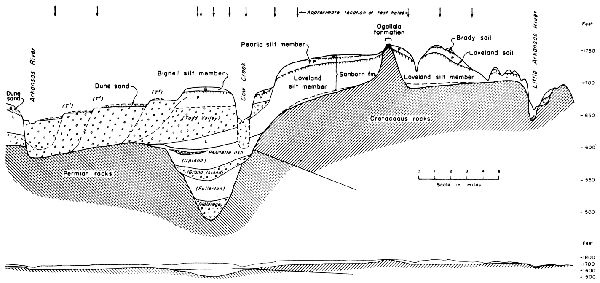
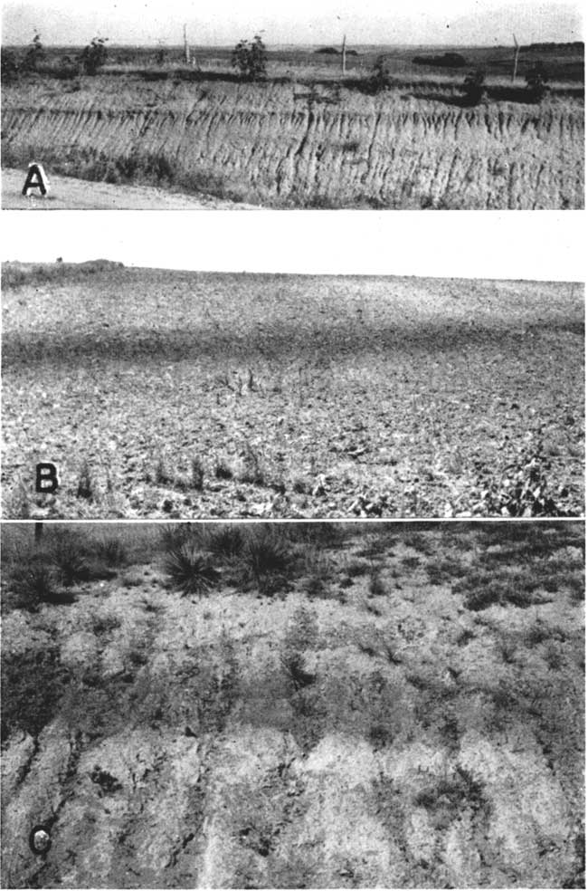
Plate 1--Buried soils in the Sanborn formation. A, Brady soil developed on Peoria silt member and overlain by Bignell silt member. Road cut, N. line, NW sec. 26, T. 2 S., R. 23 W., Norton County, Kansas. Fossil snails are abundant in the Peoria silt member below the depth of leaching of the Brady soil. B, Loveland soil overlain by Peoria silt, truncated by modern sloping surface, exposed in a plowed field. The concentration of clay in the B horizon of the soil commonly gives rise to a slight break in slope at the outcrop of the soil. NW NE sec. 21, T. 3 S., R. 12 W., Smith County, Kansas. C, Loveland soil, overlain by Peoria silt, in cut along Kansas Highway 9, sec. 18, T. 5 S., R. 23 W., Norton County, Kansas.
Along the northern tier of Kansas counties the Loveland silt occurs extensively beneath the upland levels. It commonly has a thickness ranging from 5 to 15 feet in Decatur, Norton, and Phillips counties (Fig. 2, Pl. 2A), and to as much as 40 feet where it overlies the buried early Pleistocene valleys in Jewell and Republic counties. It is more than 20 feet thick where it underlies Peoria silt on a prominent terrace along the Republican Valley in Cloud County.
Plate 2--Sanborn formation in central Kansas. A, Loveland silt member with rubble of Greenhorn limestone at base unconformably overlying Greenhorn limestone, exposed in road cut, SE cor. sec. 10, T. 1 S., R, 2 W., Republic County, Kansas. , Peoria silt member overlying Loveland soil, SE SE sec. 28, T. 25 S., R. 16 W., Phillips County, Kansas. (Photo by A. R. Leonard), C, Loveland soil exposed in road cut, showing characteristic structure of a grasslands soil in the A and B horizons, NW SW sec. 7, T. 18 S., R. 7 W., Rice County, Kansas.
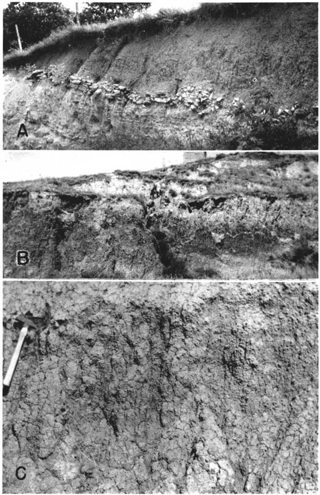
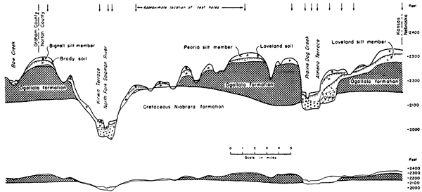
Fig. 2--Generalized north-south cross section through the Pleistocene deposits in eastern Norton County, Kansas. Based on logs of test holes drilled by the Geological Survey and on surface data. The relation of the Sanborn formation to the Cretaceous and Pliocene bedrock is shown. Name in parentheses shows tentative correlation with Nebraska classification. Ratio of vertical to horizontal scale is 100 to 1, and in the reduced cross section below, it is 20 to 1. [A larger version of this figure is available.]
South of the northern area the upland silts were examined in surface exposures and auger holes. Loveland soil was observed below Peoria silt under the uplands of Mitchell and Lincoln counties, and although deposits of Loveland silt are known to be extensive in this area its thickness is not accurately known. Its topographic position indicates a thickness of at least 20 feet under part of this extensive upland plain.
The Loveland silt member in the central Kansas area may attain a thickness of as much as 80 feet where it overlies the buried McPherson Valley, and s test hole in a buried valley in northwestern Rice County penetrated at least 90 feet of Loveland silt with Loveland soil at the top, below Peoria silt. Thicknesses of 40 to 60 feet are common in northern Rice County, and in a buried channel near Chase at least 25 feet of Loveland silt occurs unconformably below channel sands and gravels judged to be equivalent to the Todd Valley formation of Nebraska classification (note cross section, Fig. 1, and logs, Fig. 3). North of the Arkansas Valley, at least as far west as Kinsley, the uplands are mantled by as much as 15 to 20 feet of Loveland, generally capped by a distinct Loveland soil.
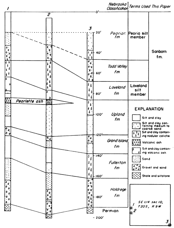
Fig. 3--Logs of three test holes penetrating the deposits of a filled valley near Chase, in the SW sec. 10, T. 20 S., R. 9 W., Rice County, Kansas. Test holes drilled by the Geological Survey. Subdivisions of the Sanborn formation and tentative correlation with Nebraska classification are shown.
Peoria silt member--The Peorian loess has been described in western Illinois and Iowa and is exposed unconformably above Loveland loess in the Missouri Valley area of Iowa and Nebraska. This unit has been traced westward from the Missouri Valley across Nebraska to Colorado (Lugn, 1935; Condra, Reed, and Gordon, 1947), and southward as far as central Kansas. Since the term Peorian is now generally used in a time sense, the adjectival ending is dropped for the stratigraphic unit here called the Peoria silt member of the Sanborn formation. The Peoria silt member in upland areas may be a complex of loesses of slightly different ages, at a few places separated by feebly developed soils (Condra, Reed, and Gordon, 1947, p. 31). Its lithologic continuity throughout Kansas and Nebraska warrants the inclusion of the complex of loesses, associated colluvial silts on some slopes, and fluvial-eolian silts on lower levels within a single member. The buried soil on the Peoria silt member is generally thinner than the Loveland soil but is recognizable in widely separated areas (Pl. 1A). It has been named the Brady soil from a locality in southwestern Nebraska by Schultz and Stout (in press). Member names are not proposed for the channel facies of these silts that may be entirely or in part equivalent in age to the Todd Valley formation and Terrace No. 3 of Nebraska classification (Condra, Reed, and Gordon, 1947, p. 49).
Peoria silt occurs extensively in the northern tier of Kansas counties (Pl. 2B) in the upland areas and on slopes, overlain locally by deposits of Bignell silt above the buried Brady soil. At the type locality of the Sanborn formation, more than 100 feet of Peoria silt is exposed and thicknesses of 50 to 75 feet have been noted in Rawlins and Decatur counties. The High Plains surface in Sherman, Thomas, and Sheridan counties is generally underlain by 30 to 50 feet of Peoria silt, and thicknesses of as much as 30 feet have been noted in Norton, Phillips, Smith, and Jewell counties.
In Cloud County, 8 to 12 feet of Peoria silt overlying Loveland soil has been penetrated in test holes on the prominent terrace along Republican River, and more than 15 feet has been observed overlying Greenhorn limestone on the uplands south of the valley. The upland surfaces in Mitchell and Lincoln counties are veneered with thin Peoria silt that is commonly 5 to 10 feet thick.
Loveland soil was encountered under the upland plain of east-central McPherson County in auger holes at depths of 2 to 6 feet, but the correlation of the surface silt with the Peoria or Bignell is not known. As much as 15 feet of comparable silt overlies the Loveland soil in the McPherson channel.
In the uplands of northern Rice County 4 to 7 feet of Peoria silt occurs above Loveland soil with Brady soil at the top. The relation of the several silt members and soils is well shown in a road cut where the following section was measured.
| Measured section in the NW SW sec. 7, T. 18 S., R. 7 W., Rice County, Kansas | Thickness, feet |
|||
|---|---|---|---|---|
| Sanborn formation | ||||
| Bignell silt member | ||||
| 4. | Silt, light tan to yellow gray; thin soil developed at top | 1.5 | ||
| Peoria silt member | ||||
| 3. | Silt, light tan, shows faint columnar cleavage; contains some very fine to fine sand and irregular nodules and tubules of calcium carbonate. Prominent Brady soil at top. | 6.4 | ||
| Loveland silt member | ||||
| 2. | Silt, dark brown gray, blocky; contains fine sand and tubules and root casts of calcium carbonate. A and upper B horizons of Loveland soil | 2.0 | ||
| 1. | Silt, tan; contains very fine sand and calcium carbonate nodules. A few snails. | 4.5 | ||
| Dakota formation | ||||
| Clay and shale | ||||
| Thickness of Sanborn formation exposed | 14.4 | |||
North of the Arkansas Valley, at least as far west as Kinsley, the uplands are mantled by as much as 4 to 10 feet of Peoria silt which overlies Loveland soil.
Bignell silt member--The name Bignell loess was proposed in 1945 by Schultz and Stout (p. 241) for deposits that overlie the soil, now termed Brady, on the uplands adjacent to the Platte Valley of western Nebraska. Deposits here included in the Bignell silt member of the Sanborn are not as continuous as the Loveland or Peoria silt members. The Bignell silt may include a complex of several loesses that in some localities include one or more feebly developed buried soils. In some places, the silts constituting the upper part of this member are so young that only an incipient soil occurs under the present surface. The channel facies of the Bignell silt may be represented by the deposits of Terrace No. 2 of central, southern, and eastern Nebraska (Condra, Reed, and Gordon, 1947, p. 49).
Few exposures that clearly show the relation of Bignell silt to the older members of the Sanborn formation have been studied in Kansas. In northwestern Kansas, thin deposits of Bignell overlying Brady soil and Peoria silt have been observed in Decatur, Graham, Greeley, Logan, Phillips, and Thomas counties, and in central Norton County, road cuts expose as much as 6 feet of Bignell above Brady soil at the top of extensive Peoria silt that is underlain by Loveland soil and Loveland silt. In central Kansas, the Bignell, where it has been recognized, is quite thin, and locally it is included entirely within the profile of the modern soil. In parts of Rice County, it is thought to be the fine-textured equivalent to the latest generation of sand dunes and sheet sand deposits, and the thin loess that occurs on lee slopes in the sharply dissected area north of the Smoky Hill Valley may be Bignell.
Condra, G.E., Reed, E.C., and Gordon, E.D., 1947. Correlation of the Pleistocene deposits of Nebraska: Nebraska Geol. Survey, Bull. 15, pp. 1-73, figs. 1-15.
Elias, M.K., 1931, Geology of Wallace County, Kansas: Kansas Geol. Survey, Bull. 18, pp. 1-254, figs. 1-7, pls. 1-42.
Frye, J.C., 1939, Physiographic significance of loess near McPherson, Kansas: Am. Assoc. Petroleum Geologists Bull., vol. 23, pp. 1232-1233.
Frye, J.C., 1945, Geology and ground-water resources of Thomas County, Kansas: Kansas Geol. Survey, Bull. 59, pp. 1-110, figs. 1-13, pls. 1-6. [available online]
Frye, J.C., 1945a, Problems of Pleistocene stratigraphy in central and western Kansas; Jour. Geology, vol. 53, pp. 73-91.
Frye, J.C., 1946, The High Plains surface in Kansas: Kansas Acad. Sci. Trans., vol. 49, pp. 71-86, fig. 1, pls. 1-3.
Frye, J.C., 1946a, Review of studies of Pleistocene deposits in Kansas: Am. Jour. Sci., vol. 244, pp. 403-416, fig. 1.
Haworth, Erasmus, 1897, Physical properties of the Tertiary: University Geol. Survey of Kansas, vol. 2, pp. 251-284, pls. 38-44.
Hibbard, C.W., Frye, J.C., and Leonard, A.B., 1944, Reconnaissance of Pleistocene deposits in north-central Kansas: Kansas Geol. Survey, Bull. 52, pt. 1, pp. 1-28, figs. 1-2, pls. 1-2. [available online]
Landes, K.K., 1930, The geology of Mitchell and Osborne counties, Kansas: Kansas Geol. Survey, Bull. 16, pp. 1-55, fig. 1, pls. 1-15. [available online]
Leonard, A.B., and Frye, J.C., 1943, Additional studies of the Sanborn formation, Pleistocene, in northwestern Kansas: Am. Jour. Sci., vol. 241, pp. 453-462, figs. 1-3, pl. 1.
Lohman, S.W., and Frye, J.C., 1940, Geology and ground-water resources. of the "Equus beds" area in south-central Kansas: Econ. Geology, vol. 35, pp. 839-866.
Lugn, A.L., 1935, The Pleistocene geology of Nebraska: Nebraska Geol. Survey, Bull. 10, pp. 1-223, figs. 1-22, pls. 1-4.
Moore, R.C., Frye, J.C., and Jewett, J.M., 1944, Tabular description of outcropping rocks in Kansas: Kansas Geol. Survey, Bull. 52, pt. 4, pp. 137-212, figs. 1-9. [available online]
Schultz, C.B., and Stout, T.M., 1945, Pleistocene loess deposits of Nebraska: Am. Jour. Sci., vol. 243, pp. 231-244, figs. 1-4, pls. 1-2.
Swineford, Ada, and Frye, J.C., 1945, A mechanical analysis of wind-blown dust compared with analyses of loess: Am. Jour. Sci., vol. 243, pp. 249-255, fig. 1.
Wing, M.E., 1930, The geology of Cloud and Republic counties, Kansas: Kansas Geol. Survey, Bull. 15, pp. 1-51, figs. 1-2, pls. 1-18. [available online]
Kansas Geological Survey, Geology
Placed on web June 8, 2007; originally published in 1947.
Comments to webadmin@kgs.ku.edu
The URL for this page is http://www.kgs.ku.edu/Publications/Bulletins/70_3/index.html