![]()
Prev Page--Comanchean || Next Page--Logs
Gulfian (?) Series
Dakota (?) Formation
General statements--Tester (1931, p. 283), after a critical study of the basal Cretaceous rocks in Kansas, Nebraska, and western Iowa, concluded that it was impractical to separate the "Dakota" rocks of Kansas-and the "Kiowa-Mentor series" of Kansas because of their close relationship and similar physical histories. Later workers (Plummer and Romary, 1942, pp. 318-319; Frye and Brazil, 1943, pp. 20-24; Swineford and Williams, 1945, pp. 111-121), however, have separated the Kiowa shale and Dakota formation on the basis of lithology and origin, the contact generally being placed arbitrarily at the top of the highest bed of marine origin.
At most places in Kansas where the Kiowa shale and Dakota formation occur together, it is difficult to determine the contact between the two formations with certainty. The contact is not abrupt as might be expected between marine and continental beds, and the boundary can not be drawn consistently above or below any one bed having a distinctive lithology, for no such bed occurs at the contact. The two formations seem to be entirely conformable and gradational. In places the contact is represented by a transition zone in which rocks having predominantly marine characteristics are interbedded with rocks having predominantly continental characteristics. This feature is well shown in a section at Natural Corral, a box canyon about 5 miles southwest of Marquette in western McPherson County, where a bed of sandstone containing terrestrial plant material occurs below the so-called "Mentor beds," which contain marine fossils and are included in the Kiowa shale (Twenhofel, 1924, p. 32; Moore, Frye, and Jewett, 1944, p. 154).
In the upper part of the Medicine Lodge Valley in the Belvidere area, the Kiowa shale grades with apparent conformity into beds of sandstone, shale, and clay which contain fossil plants and are lithologically similar to certain beds in the Dakota formation of central Kansas. These plant-bearing rocks cannot be traced into beds of known Dakota age, but on the basis of their fossils and similar lithology they are here classed as Dakota (?) formation. It is recognized, however, that the presence of fossil plants is not a diagnostic criterion and that marine rocks of the Kiowa shale may occur above these plant-bearing beds elsewhere in the subsurface. A query is used to indicate the tentative nature of the correlation.
Character--The Dakota (?) formation as herein described includes all the beds formerly classed as "Kirby clay" and "Reeder sandstone" and in addition higher beds found only in the subsurface. The line of division between the Dakota (?) formation and the Kiowa shale is arbitrarily placed at the top of the highest known bed of predominantly marine origin. The Dakota (?) formation in Kiowa County is overlain unconformably by silt, sand, and gravel of Tertiary and Quaternary age.
The best exposures are found at the head of Spring Draw (Pl. 3A, measured section 2), where about 10 feet of hard dark-brown iron-cemented sandstone containing large nodular concretions (Pl. 3B) is underlain by about 12 feet of tan and brown fine ,to medium loose sand. Below the sand is red and light-gray silty shale that grades downward into tan clay shale containing small red iron concretions, mottled red and gray clay shale, and light-gray silty shale containing thin beds of yellow-buff fine-grained sandstone. The clay and clay shale is about 20 feet thick and is underlain by sandstone of the Kiowa shale. This is the type section for Cragin's (1895, p. 381) "Reeder sandstone" (the upper sandy unit) and for Gould's (1898, p. 175) "Kirby clays" (the lower clay unit).
Plate 3A--The Dakota (?) formation (a, Gould's "Kirby clays"; b, Cragin's "Reeder sandstone") at the head of Spring Draw in the SE sec. 4, T. 30 S., R. 18 W. In the foreground are "mortor beds" of the Tertiary Ogallala formation.
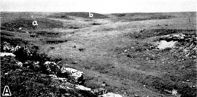
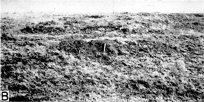
Plate 3B--Hard iron-cemented sandstone of the Dakota (?) formation. Type locality of Cragin's "Reeder sandstone." Exposure is at the end of Spring Draw opposite "b" in Plate 3A.
In an exposure in the E2 sec. 16, T. 30 S., R. 17 W., at the top of a high hill on the south side of Medicine Lodge Valley, the Dakota (?) consists of 2 feet of hard dark-brown sandstone underlain by 5 feet of tan to gray clay (measured section 3). No plant remains have been found at this locality.
Distribution and thickness--The Dakota (?) formation is exposed in only two places in the Belvidere area (Fig. 3) in the SE sec. 4 and SW sec. 3, T. 30 S., R. 18 W., and in the E2 sec. 16, T. 30 S., R. 17 W. Most of the formation was removed from this area by post-Dakota erosion. The maximum exposed thickness of the formation in the Belvidere area is 42 feet.
The Dakota formation is exposed over a wide area in central and north-central Kansas where it attains a thickness of about 275 feet (Plummer and Romary, 1942, p. 330). Smaller areas of outcrop occur north of Arkansas River in Ford, Hodgeman, Pawnee, and Barton counties, and in the extreme southwestern part of the State (Fig. 1).
Fossils--The series of beds exposed in Spring Draw (measured section 2) is correlated with the Dakota formation on the basis of their similar lithology and fossil plants. Gould (1900, p. 30) collected the following fossil plants from the Reeder sandstone (beds 6 and 7 of measured section 2):
Proterides daphnogenoides Heer
Embrothrites dapltneoides Lesquereux
Laurus plutonia Heer
Eucalyptus geinitzi Heer
Eucalyptus gouldi Ward
Eucalyptus sp.
Fragments of dicotyledonous plants have also been collected from the Kirby clay, bed 5 of measured section 2 (Twenhofel, 1924, p. 29).
No plant remains have been found in beds 15 and 16 of measured section 12, in the E2 sec. 16, T. 30 S., R. 17 W., but because of their similar lithology they are tentatively assigned to the Dakota formation.
Prev Page--Comanchean || Next Page--Logs
Kansas Geological Survey, Geology
Placed on web Aug. 28, 2007; originally published December 1946.
Comments to webadmin@kgs.ku.edu
The URL for this page is http://www.kgs.ku.edu/Publications/Bulletins/64_6/05_gulf.html