![]()
Prev Page--Nomenclature || Next Page--Gulfian
Comanchean Series
General Statements
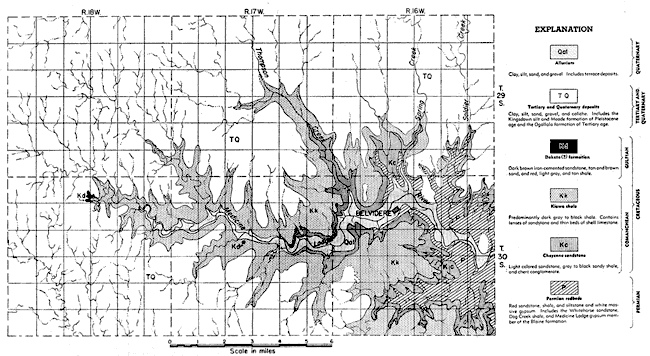
The main outcrop area, and type locality, of the Comanchean rocks of the southwestern United States is in Texas, where the thickest and most complete section is found. Other outcrop areas of Comanchean rocks occur in eastern New Mexico, southern and western Oklahoma, southeastern Colorado, and central and south-central Kansas. These have been called "outlying areas" by some writers because they are not connected with the main area of outcrop in Texas. The surface distribution of Comanchean rocks in Kansas is shown in Figure 1. Only a small part of the area shown has been mapped in detail; therefore the boundaries are generalized.
The base of the Comanchean in Kansas is marked by a pronounced unconformity. Where the base is exposed it lies on a mature erosional surface developed on various Permian rocks. A thin zone of well-rounded pebbles and cobbles occurs locally at the Permian-Cretaceous contact. In the Belvidere area this zone of pebbles and cobbles was found at the Permian-Cheyenne sandstone contact in Champion Draw, about one-half mile south of Belvidere. The pebbles here are 1 to 3 inches in diameter, are composed of gray and pink quartzite, quartz, and chert. and are embedded in a matrix of gray to yellow-tan medium sand. Some of the chert pebbles have weathered into soft gray to white granular masses that may be easily broken by hand. Charles C. Williams (personal communication) has observed a similar zone of pebbles and cobbles in western McPherson County where it occurs at the contact between the Permian and Kiowa shale, and Plummer and Romary (1942, p. 320) report its occurrence at the contact between the Permian and the Dakota formation in northern Clay County. The relationship between these pebbles and cobbles and the overlying Cretaceous rocks has not been determined. They may represent the earliest continental deposits of Cretaceous age as suggested by Plummer and Romary (19421, p. 320) or they maybe the remnants of a formerly more continuous deposit laid down during earlier Mesozoic time.
Cheyenne Sandstone
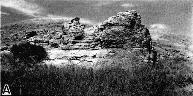
Character--The Cheyenne sandstone was named by Cragin (1889, p. 65) in 1889 from Cheyenne Rock--an indurated mass of this sandstone that forms a prominent ledge on the north side of the Medicine Lodge Valley about three-fourths of a mile west of Belvidere (Pl. 1A). It unconformably overlies the eroded surface of the Permian Whitehorse sandstone in the Belvidere area and is conformably overlain by the Kiowa shale. The upper contact in most places is sharply defined and abrupt, although Moore (in Twenhofel, 1924, fn., p. 21) believes there is evidence, at least locally, of an unconformity.
Plate 1A--Prominent ledge of Cheyenne sandstone known as Cheyenne Rock, from which the Cheyenne received its name. Cheyenne-Permian contact is concealed by weeds in foreground. Kiowa shale forms rounded hill in background. North bluff of Medicine Lodge Valley about three-quarters of a mile west of Belvidere.
The Cheyenne consists chiefly of light-colored fine- to medium-grained friable cross-bedded sandstone and lenses of sandy shale and conglomerate. Minor amounts of clay, selenite crystals, iron nodules, and pyrite occur in different parts of the formation. The bedding is extremely irregular and discontinuous so that it is impossible to trace any one bed for more than a short distance (Pls. 1A, 1C, and 2A). Most of the beds are merely lenses of limited extent.
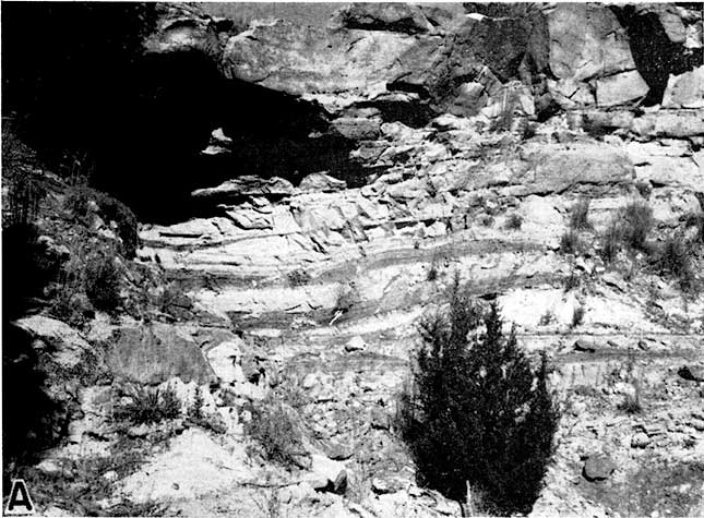
Plate 1C--Cheyenne sandstone and Kiowa shale in Champion draw. The thin bed in the middle of the picture is the shell limestone ("Champion shell bed") at the base of the Kiowa. Note how the top of the Cheyenne grades laterally from light-colored sandstone (at left) into dark-colored sandy shale (at right).
Plate 2A--Exposure of the Cheyenne sandstone in the SW sec. 26, T. 30 S., R. 16 W. Massive sandstone containing thin lenses of sandy shale (see measured section 6).
Sandstone is by far the most dominant type of rock in the Cheyenne. The most common colors of the sandstone are white, light gray, and tan, but in some places iron staining has produced beautiful shades of yellow, red, purple, and brown along bedding and lamination planes or in irregular splotches. The brightly colored zones are most common in the upper half of the formation. The texture of the sandstone ranges from flour-like material of silt and clay size to fine gravel, but fine- to medium-grained sandstone is most common. The material in general is well sorted although the degree of assortment varies from one part of the formation to another and from one locality to another.
Quartz grains comprise the greater part of the sandstone although minor amounts of other minerals are also present. Pyrite and small pellets or concretions of limonite are locally present in the sandstone. Where present, pyrite is generally found near the top of the formation, and limonite concretions, which are small and of irregular shapes, are more common in the lower part. The insoluble residues of 25 samples of Cheyenne sandstone from the Belvidere area were studied by Swineford and Williams in conjunction with an investigation of the subsurface characteristics of the Cheyenne sandstone of a part of Russell County, Kansas (Swineford and Williams, 1945). The predominant heavy minerals in the samples were zircon, tourmaline, staurolite, ilmenite, and leucoxene, but also present were small amounts of rutile, hornblende, titanite, cassiterite, and muscovite. In addition to quartz, the prominent light minerals in the samples were feldspar and chert.
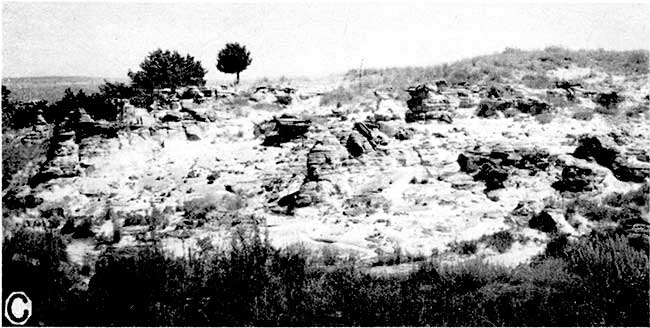
The sandstone as a whole is loosely cemented and is therefore easily eroded, but there are hard zones or layers that resist erosion. Differential erosion of the hard and soft layers by rain wash, running water, and wind has produced many fantastic and oddly shaped forms in the sandstone. Buttes, badland areas, steepwalled canyons, box canyons, high steep-sided ledges, overhanging cliffs, "chimney-rocks", "pulpit rocks", and many other forms may be seen in the outcrop area of the Cheyenne sandstone (Pls. 1A, 2A, and 3C), many of which have received names. The name "Natural Corral" has been applied to a box canyon in the middle of sec. 36, T. 30 S., R. 16 W. Another well-developed but unnamed box canyon occurs in the SE sec. 9, T. 30 S., R. 16 W. Both of these box canyons have been used in the past as corrals by putting a fence across the open end. Two prominent ledges of sandstone west of Belvidere are known as Cheyenne Rock and Osage Rock.
Plate 3C--Small badland area in the SW sec. 22, T. 30 S., R. 16 W., produced by differential erosion of the Cheyenne sandstone.
Lenses of pebble conglomerate were found at or near the base of the Cheyenne sandstone at nearly every exposure examined in Kiowa County (see measured sections 4, 5, 6, 7, 8, and 10). The conglomerate is poorly cemented and consists of pebbles of red, gray, and clear quartz and weathered white to gray chert in a matrix of fine to coarse quartz sand. Most of the chert pebbles are subangular to subrounded, and the quartz pebbles are subrounded to well rounded. The pebbles range in size from about 2 mm to about 10 mm in diameter. Most of the lenses of conglomerate range from only a few inches to 1 foot in thickness. The thickest section was found in the SW sec. 26, T. 30 S., R. 16 W., where 45.5 feet of conglomerate was measured at the base of the Cheyenne (Pl. 2B and measured section 7).
Plate 2B--Exposure of the Cheyenne sandstone in the SW sec. 26, T. 30 S., R. 16 W. Part of thick lens of conglomerate overlain by massive fine- to medium-grained sandstone (see measured section 7).
Thick lenses of gray to black sandy and silty carbonaceous shale are common in the upper part of the Cheyenne sandstone and thinner lenses of shale are found near the base. In some places the upper 5 to 16 feet consists almost entirely of shale, which laterally grades into sandstone (Pl. 1C). Remains of fossil plants, lignite, and selenite crystals are common in the shales in the upper part of the formation.
Cragin (1895, pp. 366, 367) divided the Cheyenne sandstone into two members. He named the upper member "Elk Creek beds" and the lower member "Corral sandstone" (column 10, Fig. 2). The "Elk Creek beds" were subdivided into the "Stokes sandstone" above and the "Lanphier beds" below. These units can be recognized at their type localities, but because of the lensing nature of the beds it is impossible to trace them from one exposure to another with certainty. Moreover, in many localities the shaly "Lanphier beds" are missing and the upper part of the Cheyenne consists almost entirely of sandstone. In other areas shale lenses extend to the top of the formation. Therefore, as Twenhofel (1924, p. 14) has pointed out, these divisions have no stratigraphic value beyond their type localities.
Distribution and thickness--South-central Kansas is the only place in the state where the Cheyenne sandstone is exposed. Here it crops out as an irregular narrow band around the headwaters of Medicine Lodge River, Mule Creek, Bluff Creek, and other streams in Barber, Kiowa, and Comanche counties. Exposures of sandstone in Clark County are of undetermined age but may belong to the Cheyenne sandstone. The best exposures are found in the Belvidere area where the Cheyenne crops out in irregular bands on both sides of the Medicine Lodge Valley (Fig. 3).
Fig. 3--Geologic map of the Belvidere area, Kansas. A larger version of this figure is available.
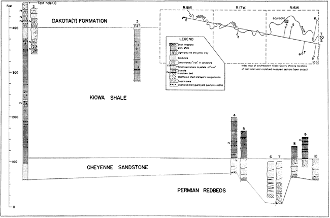
There is considerable variation in the thickness of the Cheyenne sandstone, chiefly because of the uneven erosion surface on which the sediments were deposited (Fig. 4). The measured thicknesses of the sandstone in the Belvidere area ranged from 32.5 feet in Champion Draw (measured section 4) south of Belvidere to more than 94 feet in the SW sec. 26, T. 30 S., R. 16 W. (measured section 7). The top of the formation was not present at the latter section. The average thickness of the Cheyenne sandstone in this area as based on measured sections is about 45 feet.
Fig. 4--Correlated outcrop sections of the Cretaceous rocks of the Belvidere area, Kansas. A larger version of this figure is available.
Fossils--Fossil leaves, logs, and branches are found in the Cheyenne sandstone in some places and seem to be most common in the upper part of the formation. No fossil remains of animals are known to have been collected from the Cheyenne sandstone.
The flora of the Cheyenne sandstone has been summarized and described by Berry (1922, pp. 202-203). It contains 23 species, including 4 ferns, a supposed cycadophyte seed of doubtful relationship, the fragment of a trunk of the genus Cycadeoidea, 4 coniferophytes, and 11 angiosperms of which 1 is a supposed monocotyledon and 10 are dicotyledons.
Age and correlation--The proper position of the Cheyenne sandstone within the Comanchean series has been a matter of dispute for many years. Twenhofel (1924, p. 45) placed the Kiowa shale in the Washita division of the Texas Comanchean series and stated that because the Cheyenne lies beneath the Kiowa shale it is older than the Washita. Bullard (1928, p. 53) made the following statement concerning the age of the Cheyenne:
The fact that the Cheyenne is overlain by a formation containing a very characteristic basal Washita fauna would indicate that the Cheyenne is of pre-Washita age, perhaps Fredericksburg. . . . The question of the exact correlation of the overlying formation, the Kiowa, will be discussed later and it will be shown that there are many elements of Fredericksburg aspects in it, so that until a more accurate correlation of the Kiowa is accomplished the best statement that can be made in regard to the age of the Cheyenne is that it is pre-Washita, or may represent a portion of the most basal Washita.
On the basis of the flora, Berry (1922, p. 226) concluded that the Cheyenne is younger than the Trinity and older than the Woodbine, which would place the Cheyenne in the Fredericksburg or Washita division in approximate accordance with the conclusions reached by Twenhofel and Bullard.
Origin--The Cheyenne sandstone of Kansas is generally considered to be of continental origin and to have been deposited on or near the strand line of a northward advancing Comanchean sea (Plummer and Romary, 1942, p. 340). Probably the most comprehensive discussion of the origin of the Cheyenne sandstone is that given by Twenofel (1924, pp. 18-20), who believes that the Cheyenne was deposited on a dry coastal plain, partly by aggrading streams that spread sediments over their flood plains and built deltas, and partly by wind action. Goldman (quoted by Berry, 1922, p. 204) suggested a delta origin for these sediments. Berry (1922, p. 203) believes that most of the sand was deposited by wind and that the clay was waterlaid and represents flood-plain or playa deposits.
The above explanations of the origin of the Cheyenne sandstone of Kansas have two points in common: (1) the Cheyenne is dominantly a continental deposit, and (2) sedimentation took place on or near a shore line. Whether the sediments represent eolian deposits, deposits of aggrading streams, delta deposits, or a combination of these still remains to be determined.
Kiowa Shale
The Kiowa shale, as the term is used in this paper, includes the thick series of marine shale, sandstone lenses, and fossiliferous limestones that occurs above the Cheyenne sandstone and below the Dakota formation. No member of the formation is recognized, but it includes units formerly called Champion shell bed, Spring Creek clay, Greenleaf sandstone and the lower part of Gould's (1900) Medicine Beds. It is equivalent to Twenhofel's (1924) Belvidere formation (Fig. 2). The Kiowa shale was named by Cragin (1894a, p. 49) from exposures in Kiowa County, Kansas.
Character--The contact between the Kiowa shale and the underlying Cheyenne sandstone is conformable in most places, but locally it may be unconformable (p. 235). The Kiowa shale is overlain conformably by the Dakota formation or unconformably by the Meade (Pleistocene) and Ogallala (Tertiary) formations. Although many good exposures of the Kiowa are found in this area, the top and bottom of the formation are nowhere found in the same exposure. The lower part of the formation and its contact with the Cheyenne sandstone is well exposed in the vicinity of Belvidere (measured sections 4, 5, 8, and 9) and the upper part and contact with the Dakota (?) formation is exposed in Medicine Lodge Valley and its tributary valleys several miles upstream from Belvidere (measured sections 2 and 3).
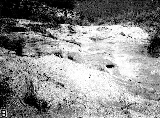
The Kiowa shale consists dominantly of thinly laminated dark-gray to black shale in the lower part grading upward into gray, tan, mottled tan, red, and brown clay and clay shale. The shale in the lower part generally is black and has been called a paper-shale because it is so thinly laminated. A conspicuous feature of the formation, especially of the lower part, is the presence of thin beds of shell limestone--a name that has been given to these beds because they consist almost wholly of fossil shells. These limestone beds are 3 to 18 inches thick, generally are light gray, and locally contain gypsum or pyrite. The matrix consists of shell fragments and sand or of sand and clay. In some places oxidation of the pyrite has caused the rock to disintegrate and the fossils have been largely decomposed. Where this has happened, the shell bed is stained with iron, which gives it a red-brown or rusty color. A shell bed at the base of the Kiowa shale was named the "Champion shell bed" by Cragin (1895, p. 368), who gave it a rank equivalent in stratagraphic value to the Cheyenne sandstone and Kiowa shale. The term "Champion shell bed," however, has only local value in designating this basal layer. The bed is persistent in parts of the Belvidere area, where it forms a prominent bench above the Cheyenne sandstone (Pl. 1B and 1C), but was not recognized in any of the test holes drilled in other parts of Kiowa County. There seems to be no essential difference between the "Champion shell bed"' and other shell beds in the Kiowa, although Cragin believed the fauna of the "Champion shell bed" was different from that of the rest of the Kiowa shale.
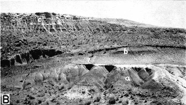
Plate 1B--Exposure of (a) Cheyenne sandstone, (b) Kiowa shale, and (c) Pleistocene deposits in the NE sec. 5, T. 30 S., R. 16 W., about 1 1/4 mile north of Belvidere.
A large lens of cross-bedded yellow-tan to buff fine-grained sandstone occurs in some places at the top of the Kiowa shale on the Greenleaf and Parkin ranches about 10 miles west of Belvidere. The thickness of the sandstone lens in Spring Draw in the SE sec. 4, T. 30 S., R. 18 W., is 29 feet (measured section 2). Smaller lenses of yellow-tan angular clay pebbles occur in the sandstone, and a thin bed of iron-cemented sandstone that contains small clay pellets and shark teeth caps the sandstone in the SE sec. 2. T. 30 S., R. 18 W. Gould (1898, p. 174) named this the "Greenleaf sandstone" from exposures on the Greenleaf ranch. Inasmuch as the sandstone is merely a lens of limited extent, differentiation of it as a stratigraphic unit is not justified. The same applies to the "Spring Creek clay"-the term Gould (1898, p. 174) used to describe the clay underlying the "Greenleaf sandstone." These units have not been recognized with certainty outside their type areas. Near the top of a high hill on the south side of the Medicine Lodge River in the E2 of sec. 16, T. 30 S., R. 17 W., about 5 feet of cross-bedded tan to buff fine-grained sandstone is exposed (measured section 3) at the top of the Kiowa shale that may be the thinned extension of the sandstone lens exposed on the Greenleaf and Parkin ranches or it may be a part of another lens. Thinner beds or lenses of sandstone occur throughout the Kiowa shale. They range from less than 1 inch to about 18 inches in thickness and consist of white or light- to dark-gray fine-grained sandstone. The "Champion shell bed" in many places is capped by a thin bed of sandstone.
Gypsum, generally in the form of selenite, is common throughout the formation and occurs both in the beds of shell limestone and at many different places in the shale. A layer of fibrous aragonite having a cone-in-cone structure was found capping beds of shell limestone in two (4 and 9) of the sections measured and was found interbedded between gray to tan shale and black shale in one section (3). Small red-brown iron concretions are found in various parts of the Kiowa shale, but are more abundant in the clay and clay-shale near the top of the formation (measured section 2). Ironstone, occurring in beds from less than 1 inch to about 20 inches in thickness, is also common in the upper part of the formation.
Distribution and thickness--The Kiowa shale is exposed extensively on beth sides of the Medicine Lodge Valley in the southeastern part of Kiowa County (Fig. 3). There is no complete section of the Kiowa exposed anywhere in this area, but the thickness of the Kiowa in test hole 1 (log 1) In the SE sec. 4, T. 30 S., R. 18 W., was 293 feet.
The Kiowa shale is exposed over a wide area in central Kansas where the maximum thickness is reported to be 100 to 125 feet (Plummer and Romary, 1942, p. 323).
Fossils--More than 50 species and varieties of invertebrate fossils have been identified from the Kiowa shale (Twenhofel, 1924, pp. 22, 23). In addition to the above invertebrates, fragments of fossil insects have been found in the black shale immediately above the "Champion shell bed" (Gould, 1899, p. 284).
Numerous vertebrate fossils have also been collected from the Kiowa shale in this area. A list of the vertebrate fossils found in the Kiowa shale is given by Twenhofel (1924, p. 23). Most of the forms described were found in the vicinity of Belvidere.
The beds formerly referred to as the "Spring Creek clay" and "Greenleaf sandstone" do not contain as many fossils as lower beds of the Kiowa. According to Gould (1900, p. 26), 12 invertebrate forms, shark teeth, and fish scales have been collected from thin sandstone beds and iron concretions of the "Spring Creek clay," which is represented by beds 1 to 3 of measured section 2. Fossils from the "Greenleaf sandstone" (bed 4 of measured section 2) are poorly preserved. They include four invertebrate forms and shark teeth (Gould, 1900, p. 26).
Age and correlation--That the Kiowa shale is of Comanchean age has not been questioned since Cragin (1889, p. 37) and Hill (1889, p. 115) first correlated the fauna of the Kiowa with the fauna of the Comanchean series of Texas. The proper position of the Kiowa shale in the Comanchean series of Texas, however, has been a matter of dispute for many years. The first attempt at correlating the Kiowa shale with a specific part of the Texas section was made by Hill (1889, p. 115), who correlated the basal shell bed ("Champion") with the Fredericksburg division. Cragin (1890, p. 75) correlated all of the marine beds that overlie the Cheyenne sandstone with the Fredericksburg division. In 1895 Hill (p. 273) changed his earlier correlation and stated that the fauna of the Kiowa shale was characteristic of the Washita division. In a letter quoted by Prosser (1897, pp. 114-115), Cragin maintained that the fossils from the "Champion shell bed" and those from the overlying shales comprised two distinct faunas and stated that the "Champion shell bed" should be referred to the Fredericksburg and the overlying shales to the basal Washita. Twenhofel (1924, pp. 23-45) said that there are no essential differences between the faunas of the "Champion shell bed" and the overlying shales. He placed the Kiowa shale in the Washita division but recognized that there are some things in the fauna of Fredericksburg aspect. Bullard (1928, p. 61) correlated the Kiowa shale (except the Champion shell bed) with the Kiamichi clay (basal Washita) of the southern Oklahoma and northern Texas section and the "Champion shell bed" with the Goodland limestone (Fredericksburg), but stated that the line between the Fredericksburg and the Washita was difficult to establish on the basis of paleontologic evidence.
The available evidence indicates, therefore, that the Kiowa shale is equivalent in age to the Washita division and possibly in part to the Fredericksburg division of the Texas section.
The upper part of the Purgatoire formation of western Oklahoma (Stovall, in Schoff, 1943, p. 79) and southeastern Colorado (Sanders, 1934, p. 865) has been correlated with the Kiowa shale of southern Kansas.
Origin--The Kiowa shale is marine in origin and probably represents shallow-water deposition of a transgressing sea. Detailed descriptions of the mode of deposition of the Kiowa have been given by Twenhofel (1924, pp. 26, 27) and Plummer and Romary (1942, pp. 340, 341).
Prev Page--Nomenclature || Next Page--Gulfian
Kansas Geological Survey, Geology
Placed on web Aug. 28, 2007; originally published December 1946.
Comments to webadmin@kgs.ku.edu
The URL for this page is http://www.kgs.ku.edu/Publications/Bulletins/64_6/04_coman.html