![]()
Prev Page--Introduction || Next Page--Comanchean
Historical Summary of Cretaceous Nomenclature
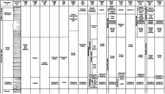
The following review of tho development of the present classification of the Cretaceous rocks of southern Kansas includes only papers dealing with the classification and nomenclature of these rocks. Papers describing the lithology, paleontology, or paleobotany of the various rock units are cited in the descriptions of the various formations. Figure 2 shows in chart form a generalized geologic section of the Cretaceous rocks of southeastern Kiowa County, the classifications that have been applied to these rocks by various authors in the past, and the classification used in this paper.
Fig. 2--Generalized geologic section of the Cretaceous rocks of the Belvidere area showing the classifications that have been supplied to these rocks by various authors in the past and the classification used in this paper. A larger PDF version of this figure is available.
The first reference to the geology of the southern Kansas area was made by Mudge in 1878 (p. 55). On a geologic map of the State (p. 47) he shows Upper Carboniferous and Cretaceous rocks in Kiowa County, the dividing line passing diagonally from the northeastern corner to the southwestern corner of the county. Mudge (p. 55) states that the area south of Arkansas River and west of Harper County had received little work but seemed to be represented by the "Fort Benton and Dakota groups." St. John published a geologic map of the state in 1883 on which he shows Cretaceous rocks covering all of Kiowa County.
The first description of the rocks in southeastern Kiowa County was given by Cragin in 1885 (p. 90):
They belong to the Benton and later deposits . . . . The deposit (at the Black Hill) is a bed of carbonaceous and rapidly decomposing shale. In connection with the shale are found fragmentary seams of poor lignite. Immediately above and below this is a layer of shell conglomerate made up largely of Ostrea and Gryphaea.
Below these is a formation quite unlike any other I have seen or heard of in Kansas . . . . It is a variegated sandstone . . . displaying a most beautiful variety of colors . . . . I have no positive evidence of the Niobrara here as yet, but I am inclined to think it here, and that it would be found to begin shortly above the horizon of the Black Hill shale.
Black Hill, to which Cragin refers, is in the southeastern corner of Kiowa County in sec. 36, T. 30 S., R. 16 W.
The following year Cragin (1886, p. 166) changed his earlier correlation of the Black Hill section by concluding that the variegated sandstone marked the upper limit of the Dakota and the overlying dark shale marked the base of the Benton. A year later, St. John (1887, pp. 143-144) wrote:
. . . . only the Dakota and Niobrara members [of the Cretaceous] have been with certainty identified in this southwest region . . . . The lowermost deposits [of the Dakota formation] consist of soft white-and-yellow-stained sandstone, in places obliquely laminated, with hard, indurated layers, the weathering of which produces monumental forms . . . . This sandstone . . . is succeeded by dark blue, drab and buff shales, 50 to 70 feet, including above a soft yellow, sometimes reddish, obliquely laminated sandrock, five feet, more or less, and below a stratum of drab, sometimes sandy, shales two to five feet, containing streaks of lignite and fragments of bituminized wood . . . .
Succeeding the shale horizon occur successive beds of shaly limestone, alternating with drab and buff, more or less arenaceous shales, which are charged with fossils, mostly belonging to a species of Gryphaea resembling G. Pitcheri, an Exogyra, Trigonia, Turritella . . . etc . . . . . The association of species and abundance of individuals strongly recall occurrences in Texas . . . it would appear that the present region marks the limits of the northern extension of this peculiar southern fauna of the Cretaceous . . . .
Hay (1887, p. 22) said that the variegated sandstone referred to by Cragin was undoubtedly Dakota and that where he had observed the base it seemed to rest on the eroded surface of the "Red Rock".
Cragin (1889, pp. 35-37) published the first detailed description of a section of Cretaceous rocks southwest of Belvidere on Medicine Lodge River and listed the fossils collected from them. He notes that in an earlier paper he (pp. 33, 37)
. . . . wrongly assigned all the formations between the great gypsum horizon and the base of the Tertiary southwest of Sun City to the Benton epoch. . . .
The . . . . study of the Medicine River Cretaceous suffices to show something very like the fauna of the recently discovered Comanche series of Texas, which is said to be lower than the Dakota, or lowest hitherto known American Cretaceous.
Hill (1889, p. 115), in referring to Cragin's paper, said that the rocks in Kiowa County represent the Comanchean series, and he correlated the variegated sandstone with the Trinity division of the Texas coastal plain region and the overlying shell bed with the Fredericksburg division. Cragin (1889a, p. 65) tentatively accepted Hill's correlation for the sandstone and named it the Cheyenne sandstone, from Cheyenne Rock opposite Belvidere, Kiowa County, Kansas. The following year Cragin (1890, 1890a) described more fully the lithology, paleontology, thickness, and distribution of the Cheyenne sandstone and overlying shale, the latter of which he placed in the Fredericksburg division.
Hay made a reconnaissance of the geology of southwestern Kansas in 1885 and in his report (Hay, 1890, pp. 27-30) correlated the lower sandstone (Cheyenne) with the Dakota and the shell bed and black shale with the Fort Benton, but stated that he realized that the beds above the "Jura Trias" (Permian) might possibly belong to the Comanchean series of Texas.
In 1891 Cragin visited the Comanche rocks in northern Texas with Hill and agreed with him in correlating the Cheyenne sandstone of Kiowa County with the Trinity sandstone of Texas and the shales overlying the Cheyenne with the Fredericksburg shale (Cragin 1891a, pp. 179-181). The first geologic map to show Comanchean rocks in Kansas was published the following year by Williston (1892); on this map "Comanche Cretaceous" rocks are shown in the southeastern and southwestern corners of Kiowa County.
Hay outlined the geology and mineral resources of Kansas and described the different geological formations of the state. In describing the strata above the redbeds along the Medicine Lodge Valley, he said (Hay, 1893, pp. 108-109):
. . . . there seems no doubt but that they belong to lower horizons than the Kansas Dakota. There is no reason why the Texan names given to the beds--Trinity for the lower, fine-grained sandstones, and Comanche Peak for the upper strata--should not be permanent, but some of the paleontologists still differ as to whether certain of the shells are Lower Cretaceous or of the Jurassic type. . . . I have placed them as Lower Cretaceous.
In 1894 three reports dealing wholly or in part with the Comanchean rocks of southern Kansas were published by Cragin (1894, 1894a, 1894b). In the second paper Cragin (1894a, p. 49) named the black shale above the Cheyenne sandstone the Kiowa shale, stating:
The designation, Kiowa shales, is proposed for the inferiorly dark-colored and superiorily light-colored shales that outcrop in several of the counties of southwestern Kansas, resting upon the Cheyenne sandstone in their eastern, and upon the "Red-beds" in their middle and western exposures, and being overlaid by brown sandstones of middle Cretaceous age, or Tertiary or Pleistocene deposits, according to locality.
The Kiowa shales are a locally modified northern extension of part of Hill's Comanche series, cut off from the main part by erosion. They are named from the place of their typical occurrence, Kiowa County, Kansas. . . .
In 1895, Hill (p. 273) announced the discovery of a typical dicotyledonous flora in the Cheyenne sandstone and stated:
This sandstone has heretofore been referred to the Trinity Division of Texas by Prof. F. W. Cragin, but the flora . . . . consists entirely of species hitherto supposed to be peculiar to the Dakota Group, while the flora of the Trinity Division of Texas . . . . is all of the non-dicotyledonous Potomac type. The Cheyenne sandstones are separated from the true Dakota sands of Kansas by nearly 200 feet of shale, containing a molluscan fauna . . . . characteristic of the Washita Division of the Comanche Series of Texas . . . .
Later in the same year Hill (1895a) described the flora of the Cheyenne sandstone and the fossils of the overlying shale, gave measured sections of Stokes Hill (Cragin's Black Hill) and Blue Cut (a railroad cut southwest of Belvidere), and correlated the Cretaceous rocks of southern Kansas, Oklahoma, and New Mexico. In introducing the term "Belvidere shales" for shale that lies above the Cheyenne sandstone, Hill says (1895a, p. 211):
Since writing this paper Prof. Cragin has proposed the name Kiowa for the shale beds. The name would no doubt have priority over the one herein used by me, but owing to doubt as to which sub-division Prof. Cragin would have included the beds 2, 3, and 4 (Cheyenne sandstone), I prefer to retain for the present the term Belvidere shales.
In his Blue Cut section, Hill (1895a, p. 210) lists the Cheyenne sandstone, "Belvidere shale", "Dakota' sandstone", and "Plains Tertiary." He says (1895a, p. 211) that these formations may be grouped into a generalized section which is characteristic of the bordering breaks of the plains in southern Kansas, western Oklahoma, and northeastern New Mexico. He calls this the Plains section (column 9, Fig. 2). Hill (1895a, pp. 223, 226-227) disagreed with Cragin's correlation of the Cheyenne sandstone and Kiowa shale, stating:
. . . . these fossils from the Kiowa shale are largely of the age of the Washita division of my Texas section, and not solely the Fredericksburg and Trinity divisions as maintained by Cragin . . . . The Belvidere beds represent in general the Washita division and probably the attenuated Fredericksburg as seen in the north Texas sections . . . . The Cheyenne sandstones are of far later age than the Trinity, and occupy a stratigraphic position at the base of the Washita midway between the Trinity and Dakota.
Cragin (1895) discussed Hill's conclusions and introduced two new formation names and several member names. He said (1895, p. 057) that he had formerly used the name "Belvidere" in a manuscript to designate the Comanchean shales of southern Kansas but withheld it from publication because of its similarity to the term "Belvedere,"--a name already given to certain Tertiary sand and gravel beds of Austria. He also proposed that, if the term "Belvidere" were retained, it should be used as a group name to include the Cheyenne sandstone and Kiowa shales, and not as a synonym for the name "Kiowa". This is the usage given "Belvidere beds" in Hill's (1895a, p. 211) Plains section. Cragin (1895, p. 368) gave formation rank to the thin shell bed at the base of the Kiowa shale and called it the "Champion shell bed," from Champion Draw--a small tributary of Medicine Lodge River south of Belvidere, and described the "Champion shell bed" as a "thin stratum of gray shell-conglomerate. " He adds:
In the Belvidere district proper the Champion shell-bed is remarkably persistent, though commonly less than a foot and rarely more than a foot and a half in thickness. Sometimes the bed consists almost wholly of shells cemented into rock by means of arenaceous limestone and calcite, again of a matrix of sand and clay mingled in varying proportion, containing few or many fossils and more or less impregnated with iron oxide and carbonate and sulphate of lime . . . . the forms of Invertebrata known from it already number thirty-six, or more than half of the entire number known from the lower Cretaceous sediments of Kansas south of the Arkansas River.
The Cheyenne sandstone was subdivided by Cragin (1895, p. 366) into the "Corral sandstone" below and the "Elk Creek beds" above. The "Corral sandstone"--named for Natural Corral, a short box canyon in the southeastern corner of Kiowa County--consists of 30 to 50 feet of sandstone. Cragin (1895, p. 366) says that the lower part of it is white, but the upper part is often beautifully variegated with the various bright reds mingled with yellow, purple, and brown. The upper part of the Cheyenne sandstone was named the "Elk Creek beds" because of exposures at the head of Elk Creek in southeastern Kiowa County (Cragin, 1895, p. 366), and Cragin subdivided the "Elk Creek beds" into the "Lanphier Beds" below and "Stokes sandstone" above. The "Lanphier beds" were named from exposures in a draw that runs through the Lanphier claim. Cragin (1895, p. 367) describes them as comprising
. . . . some ten or fifteen feet of incoherent, more or less shaly sands, sometimes passing into shales, often heavily charged with carbonaceous matter, pyrites of iron and selenite crystals, and including numerous fragments of lignite.
According to Cragin (1895, p. 367) the "Lanphier beds" grade upward into the "Stokes sandstone," which is
. . . . a few feet in thickness . . . . and . . . . consists of more constantly arenaceous and consolidated sediments. It is named from one of the localities of its outcrop, the head of what may be called Stokes draw, which proceeds from the foot of Stokes Hill near and south of Lanphier draw. At one of the . . . . localities on South Elk Creek . . . . the sandstone of the Stokes horizon, like that part of the Corral horizon at the same locality, is brilliantly colored, scarlet and other shades of red.
The Kiowa shale was subdivided by Cragin (1895, pp. 379-381) into two divisions, the lower of which was called "Fullington shales," from the Fullington ranch near Belvidere, and the upper the "Tucumcari shales," for Mount Tucumcari, New Mexico. A zone of Gryphaea tucumcarii, which characterizes part of the "Tucumcari shales," was originally discovered at Mount Tucumcari. The "Fullington shales," according to Cragin (1895, p. 379)
. . . . include the lower and major part of the Kiowa shales. They are not sharply separated from the overlying Tucumcari shales either lithologically or paleontologically. They include that portion of the Kiowa shales in which the Gryphaea is Marcou's G. roemeri.
Cragin further subdivided the "Fullington shales" into the "Black Hill shale" and the "Blue Cut shale". In describing the "Black Hill shale," Cragin (1895, p. 379) wrote:
. . . . the name was derived from the Black Hill adjoining Hell's Half acre on Elk Creek in Comanche County. The terrane consists of a bed of black carbonaceous clay-shale fifteen or twenty feet thick, resting upon the Champion shell-bed and characterized by a peculiar method of disintegration, breaking down under the weather into small, flat and thin, sharp-edged spalls resembling wafers, a peculiarity that has suggested for this shale the name of Wafershale.
The "Blue Cut shale" was named from a railroad cut a few miles south-southwest of Belvidere which was known by that name. This division was reported (Cragin, 1895, p. 380) to consist of
alterations of blue-black and gray argillaceous shales with minor beds of sandy shale, ferruginous sandstone and shell limestone.
Concerning the "Tucumcari shale," Cragin (1895, p. 381) stated:
The shells of the genus Gryphaea increase in size as found in successively higher horizons of the Belvidere beds from the appearance of the genus in the Champion shell-bed to its disappearance just below the base of the leaf-bearing Reeder (Dakota?) sandstone which surmounts the Kiowa shales in the upper valley of the Medicine Lodge River near the post office at Reeder . . . . To the zone characterized in part by . . . . G. tucumcarii, the name Tucumcari shales is here given . . . .
They are chiefly clay-shales, and lighter hued, as a whole, than the Blue Cut shales, which graduate insensibly into them. At their summit, they frequently contain bands and concretions of clay-ironstone . . . .
This is the first mention of the term "Reeder sandstone" in published literature. Cragin's complete classification of the Cretaceous rocks of southern Kansas is given in column 10, Figure 2.
A comprehensive report by Prosser (1897) on the Comanchean series of Kansas, including several measured sections and a thorough review of all previous work, recognizes this series as comprised of two formations--the Cheyenne sandstone and Kiowa shale--that are readily distinguished by both lithologic and paleontologic characters (column 11, Fig. 2). Prosser (1897, p. 114) considered the "Champion shell bed" as the basal part of the Kiowa shale. Concerning ferruginous sandstone occurring above the Kiowa shale in the upper part of Medicine Lodge Valley Prosser (1897, p. 118) says:
. . . . the writer . . . . in correlating this sandstone doubtfully with the Dakota simply follows the general custom. The writer, however, understands that Professor Cragin in his last paper has proposed for this ledge the name Reeder (Dakota?) sandstone . . . .
Gould (1898), after spending parts of four summers in the southern Kansas area, described a series of "transition beds" from the "Comanche to the Dakota Cretaceous," introducing several new names and giving the classification of the Cretaceous rocks shown in column 12, Figure 2. He used the term Cheyenne sandstone and Kiowa shales in the same sense as Prosser (1897), and wrote in regard to strata above the Kiowa shales (Gould, 1898, pp. 174-175):
. . . . The Spring Creek clays are named for Spring Creek, a southern tributary to the Medicine River 12 miles west of Belvidere, on which the clays are well exposed. The Greenleaf sandstone is named from the Greenleaf ranch on which the sandstone was first studied, and the Kirby clays from the Kirby (also known as the C. W. or Fullington) ranch on which the clays have a typical exposure. Professor Cragin's term, Reeder sandstone, is used to include all the sandstone between the Kirby clays and the true leaf-bearing Dakota. The entire series of transition beds is included under the term Medicine beds, named from the river near the head of which the beds are best studied.
The term "Dakota sandstone" refers to the true leaf-bearing sandstone. Spring Creek, to which Gould refers, is now known as Spring Draw, the name Spring Creek being applied to a northern tributary of Medicine Lodge River just east of Belvidere. Gould (1898, pp. 171-173) lists three sections of rocks that he measured on the Greenleaf and Kirby ranches. The Greenleaf and Kirby (now Parkin) ranches are about 10 miles west of Belvidere and 10 miles south of Greensburg.
In 1900 Gould described the Cretaceous rocks of southern Kansas more fully and classified them as shown in column 13, Figure 2. The names "Corral sandstone," "Lanphier beds," and "Stokes sandstone" apply only in the limited area where they were described (Gould, 1900, p. 18), and concerning the "Medicine beds" he stated (p. 25):
As used in my paper [Gould, 1898] the term included the dark brown sandstone, usually concretionary, below the true leaf-bearing Dakota. Leaves have since been found in the Reeder and the term [Reeder] becomes synonymous with Dakota.
In his conclusions Gould (1900, p. 40) stated:
. . . . Comanche fossils are known to extend many feet into the sandstones which were once considered Dakota, and even above horizons yielding typical Dakota leaves. . . . The opinion of the writer is that by the law of priority the base of the Dakota will eventually be recognized at the lowest stratum above the Cheyenne yielding typical Dakota leaves.
Gould later (1901, p. 133) discarded the term "Medicine beds" and said that the transition beds above the Kiowa shale should be classed either in the Comanchean or Dakota, although he was unable to draw a line between the two.
A report on the geology and underground water of the central Great Plains by Darton (1905) includes brief statements on the Cretaceous rocks of Kiowa County. The Comanchean series or Lower Cretaceous in central-southwest Kansas is considered to be represented by two formations: the Cheyenne sandstone and Kiowa shale (column 14, Fig. 2). In describing the Dakota formation of Kansas Darton stated (1905, p. 152):
Some outcrops of sandstone in the head of Medicine Lodge River, in the southeast corner of Kiowa County, are doubtfully referred to the Dakota; they lie directly upon upper members of the Comanche series.
The sandstone to which he refers probably is that described as the "Reeder sandstone" by Cragin and Gould.
In a report on the Comanchean and Dakota strata of Kansas, Twenhofel (1920, pp. 282-286) briefly describes the Cheyenne sandstone, Kiowa shales, and "Medicine beds" and discusses their origin. He uses the names "Spring Creek," "Greenleaf," "Kirby," and "Reeder" for the divisions of the "Medicine beds" (column 15, Fig. 2), as Gould (1898) had, and gives evidence for placing the Dakota of Kansas in the Comanchean series instead of at the base of the Upper Cretaceous.
Stanton (1922, p. 261) discusses some problems connected with the Dakota sandstone, as follows:
In the southern Kansas section . . . . the upper part of the Dakota and all of the later Cretaceous formations have been removed by erosion; there is a greater thickness of marine beds, with a well developed and distinctive Comanche fauna, represented in the sandstones which seem to form a transition to the Dakota; and at the base is the Cheyenne sandstone . . . . The flora of the Cheyenne sandstone resembles the Dakota flora, but may be specifically distinct.
The flora and origin of the Cheyenne sandstone were described by Berry (1922, pp. 202-203) who lists 23 fossil plants from the Cheyenne sandstone in the immediate vicinity of Belvidere. The "Spring Creek clay," "Greenleaf sandstone," "Kirby clay," and "Reeder sandstone," according to Berry (p. 199),
. . . . are chiefly local phases or lentils in the Kiowa, of little significance except as indicative of local and more or less contemporaneous variations in conditions of deposition, with perhaps a basal member of the Dakota sandstone represented in the "Reeder".
Twenhofel (1924) described in detail the geology and invertebrate paleontology of the Comanchean and "Dakota" formations of Kansas, and divided the rocks of southern Kansas into three formations: the Cheyenne sandstone, Belvidere formation, and "Dakota" formation (column 16, Fig. 2). The Cheyenne was used without modification of previous usage, but in regard to Cragin's divisions of the Cheyenne, Twenhofel (1924, pp. 14-15) says:
The writer does not consider it possible definitely to recognize any member beyond the limits of one locality, and the divisions of Cragin . . . . are considered to have no validity for more than local application . . . .
Concerning the upper two members of the Belvidere formation, Twenhofel (1924, pp. 27, 28) says:
The writer is not certain to what extent the differentiation of the Spring Creek and Greenleaf members as distinct from the Kiowa is justified, but since it has been done, and there are differences in the character of the sediments, it is considered best to continue the usage of these terms.
In describing the subsurface distribution of the Comanchean rocks in western Kansas, Twenhofel and Stryker (1925, p. 1105) held that in south-central Kansas the Comanchean strata consist of the Cheyenne sandstone at the base and the "Belvidere formation" above. They add:
Above the Belvidere formation are red sandstones of scattered and limited distribution which have been named the "Reeder formation". These belong to the "Dakota".
Bass (1926, pp. 59, 73-76) used the name "Dakota sandstone" to describe the strata between the Graneros shale and the Permian in Hamilton County, but stated that possibly it included representatives of the Purgatoire formation of eastern Colorado.
A lengthy report by Bullard (1928) on the Lower Cretaceous of western Oklahoma includes a discussion of the stratigraphy of the Lower Cretaceous rocks in the Belvidere area, Kiowa County. He discarded the term "Belvidere formation," elevated the members to formations, and for convenience of description, separated the "Champion shell bed" from the Kiowa shale, but says (192?, p. 50): ". . . . considered from the standpoint of the Kansas area alone, the Champion may well be included with the Kiowa." Bullard's (1928, pp. 50-63) classification of the Lower Cretaceous rocks of the Belvidere area is shown in column 17, Figure 2. He apparently considered the top of the "Greenleaf sandstone" to be the top of the Lower Cretaceous of this area, for he does not mention any of the beds above the "Greenleaf".
Elias (1931, p. 28; 1937, p. 10) and Landes and Keroher (1939, p. 24) grouped all of the Cretaceous rocks below the Graneros shale in western Kansas into the Dakota group. Tester (1931, pp. 234-283) assigned the name "Dakota stage" to the succession of sandstone and shale that lies beneath the Graneros shale and above the Pennsylvanian rocks at the type locality in eastern Nebraska, and stated that the Washita-Kiowa-Mentor series of Kansas belonged to the same general sequence as the Dakota stage.
In 1937, the Kansas Geological Survey (Moore and Landes, 1937) used the term Dakota group to include all Cretaceous strata below the Graneros. At a conference of Survey geologists in Lawrence in January 1941, a decision was reached by the state geologists to continue the use of the term "Dakota group" as interpreted by Tester (1931), which was to include all the strata from the base of the Cheyenne sandstone to the base of the Graneros shale. Local names were to be used for the subdivisions of the group in those areas where it was possible to subdivide it. Accordingly, all Cretaceous strata of Stanton County, Kansas, were placed in the Dakota group and subdivided into three formations: the Cheyenne sandstone at the base, the Kiowa shale, and the Cockrum sandstone (Latta, 1941, p. 70). This same classification was used in Morton County by McLaughlin (1941, p. 74).
In February 1942, several, conferences were held by Survey geologists in Lawrence on the nomenclature and classification of the pre-Greenhorn Cretaceous deposits of Kansas. As a result, the term "Dakota group," which formerly included the Cheyenne sandstone, the Kiowa shale, and the overlying beds to the base of the Graneros shale, was abandoned by the Kansas Geological Survey. In explanation Waite (1942, p. 137) wrote:
The group as previously defined, transgressed the Upper Cretaceous-Lower Cretaceous boundary line; a multiplicity of names has existed for the various units involved, many of them having been applied to such nonpersistent units as channel sandstone that cannot be correlated with certainty beyond the confines of their type localities, many of the stratigraphic units were never adequately described. Moreover, the Dakota group, as used previously in Kansas, could not be correlated with the Dakota sandstone at the type locality; it was not acceptable to the Committee on Geologic Names of the U.S. Geological Survey; it did not constitute a satisfactory genetic grouping of strata; and the term Dakota group was confused with other usages of Dakota and almost universally implied a sandstone.
It was proposed, therefore, to use the term "Dakota formation" for the nonmarine beds above the Kiowa shale and below the Graneros shale. This term was formally adopted for use in the main area of outcrop in central Kansas.
In a recent paper by Plummer and Romary (1942), the pre-Greenhorn Cretaceous beds of central Kansas are described and classified according to the revised usage of the State Geological Survey of Kansas. Their classification includes three Cretaceous formations below the Graneros shale: Dakota formation, Kiowa shale, and Cheyenne sandstone. The term "Cheyenne sandstone" is used in the same sense as originally defined by Cragin (1890) and includes (Plummer and Romary, 1942, p. 319)
"sandstone strata of continental origin that lie unconformably on Permian rocks and that conformably underlie the Kiowa shale."
Plummer and Romary (p. 319) retained the name Kiowa shale "to designate the dark-colored marine shale, sandstone, and fossiliferous limestone, which occur above the Cheyenne sandstone and below the beds here included within the Dakota formation." The Dakota formation (p. 319):
. . . . is restricted to include only the continental and littoral beds that occur above the Kiowa shale and below the Graneros shale. . . .
The Dakota formation is divided into parts, the lower of which is named the "Terra Cotta clay member" and the upper, the "Janssen clay member." The Terra Cotta member is defined to include massive clay, silt, and sandstone comprising approximately the lower two-thirds of the Dakota formation. The most conspicuous lithological feature of the Terra Cotta member is the widespread distribution of gray-and-red-mottled massive clay. The Janssen member includes beds of lignite, gray to dark-gray massive clay, silt, and some shale above the Terra Cotta member and below the Graneros shale.
The term "Dakota" has since been used as a formation name in Ford County (Waite, 1942, p. 141), Hamilton and Kearny Counties (McLaughlin, 1943, p. 120), Ellis and Russell Counties (Frye and Brazil, 1943, p. 21), and Finney and Gray Counties (Latta, 1944, p. 145).
Prev Page--Introduction || Next Page--Comanchean
Kansas Geological Survey, Geology
Placed on web Aug. 28, 2007; originally published December 1946.
Comments to webadmin@kgs.ku.edu
The URL for this page is http://www.kgs.ku.edu/Publications/Bulletins/64_6/03_nomen.html