![]()
Prev Page--Introduction || Next Page--Quality of Ground Water
Geology
Stratigraphy and Criteria Used for Subsurface Identification
The formations encountered in the test holes studied were of Permian, Cretaceous, Tertiary (?), and Pleistocene age. The Permian rocks have been tentatively classified as the Cedar Hills sandstone and the Salt Plain formation belonging to the Nippewalla group (Frye and Brazil, 1943, p. 16). Above the Permian, in ascending order, are the Cheyenne sandstone, Kiowa shale, Dakota formation, Graneros shale, Greenhorn limestone, and the Fairport chalky shale member of the Carlile shale. Where the Cheyenne sandstone is absent, the Kiowa shale lies directly upon Permian rocks. The uppermost deposits, unconformably overlying the Cretaceous rocks in the test holes, are here grouped as Tertiary (?) and Pleistocene rocks. A detailed discussion of the Cretaceous stratigraphy of the area has been given by Frye and Brazil (1943), and Rubey and Bass (1925) have also reported on the Cretaceous stratigraphy of Russell County. The physical characteristics of these formations as observed in test-hole samples are summarized below.
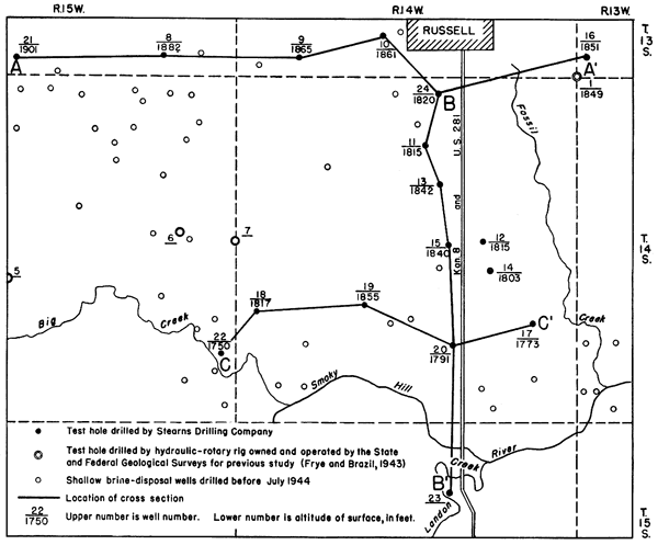
The formations are listed in Table 1, which is adapted from a similar table by Frye and Brazil (1943, p. 13). Locations of the test holes are shown in Figure 2. Numbers 22, 23, and 24 are commercial shallow disposal wells not drilled for the State Board of Health. Numbers 1, 5, 6, and 7 are holes drilled using a portable hydraulic-rotary drilling machine owned and operated by the State and Federal Geological Surveys for the investigation by Frye and Brazil (1943).
Table 1--Generalized section of geologic formations in test holes in southwestern Russell County.
| System | Series | Subdivisions | Thickness (feet) |
Physical Character | |
|---|---|---|---|---|---|
| Quaternary | Pleistocene | McPherson (?) formation and younger and older beds |
0-105 | Gravel, sand, silt, clay, and volcanic ash; locally cernented by calcium carbonate. Gravels contain igneous and limestone pebbles. | |
| Tertiary | 0-40 | Gravel, sand, silt, and clay; locally cemented by calcium carbonate. | |||
| Cretaceous | Gulfian* | Carlile shale |
Fairport chalky shale member |
45± | Shale, blue gray, massive to thin-bedded. |
| Greenhorn limestone |
Pfeifer shale member |
90-98 | Shale, and limestone, interbedded. Shale is calcareous, gray to black; limestone is thin-bedded, fossiliferous, gray. | ||
| Jetmore chalk member |
|||||
| Hartland shale member |
|||||
| Lincoln limestone member |
|||||
| Graneros shale | 14-40 | Shale, blue gray to brownish black, locally contains clay, siltstone, and sandstone. Contains pyrite. | |||
| Dakota formation |
Janssen clay member | 213-300 | Clay, shale, siltstone, and sandstone interbedded and varicolored. Contains abundant siderite, hematite, and limonite, and some lignite. | ||
| Terra Cotta clay member |
|||||
| -- ?? -- | |||||
| Comanchean | Kiowa shale | 50-105 | Shale, dark gray to black, containing beds of sandstone and siltstone and crystals of pyrite. | ||
| Cheyenne sandstone | 0-62 | Sandstone, medium to fine-grained, gray, and some shale and siltstone. | |||
| Permian | Leonardian* | Nippewalla group* | Siltstone, fine-grained sandstone, and shale; red and gray; loosely cemented. | ||
| *Classification of the State Geological Survey of Kansas. | |||||
Figure 2--Map of part of Russell County, Kansas, showing locations of test holes and brine-disposal wells.
Quaternary and Tertiary (?) Rocks
Deposits either of Pleistocene or Pleistocene and Tertiary age were found immediately below the surface in all except three of the test holes. The material consists of buff-colored clay, silt, sand, and gravel, locally cemented by calcium carbonate. Where present it ranges in thickness from 10 feet in test hole 12, one of the upland holes, to 105 feet in test hole 17 near Fossil Creek, a tributary to the Smoky Hill River. A map by Frye, Leonard, and Hibbard (1943) indicates that test holes 17, 18, 20, 22, and 23 were drilled into a high-terrace deposit of Pleistocene age, which was referred by them to the McPherson (?) formation. The test holes to the north, nos. 8, 9, 10, 12, 13, 15, 16, and 21, were drilled on the upland. The silt and sand deposits on this upland have been described by Frye, Leonard, and Hibbard (1943, p. 34) as "probably younger than the Ogallala formation of central Ellis County and . . . . certainly older than the high-terrace deposits along the Smoky Hill Valley."
Cretaceous Rocks
In the area under discussion the Tertiary (?) and Quaternary deposits are underlain unconformably by Cretaceous rocks which range downward from the Fairport chalky shale member of the Carlile shale to the upper part of the Dakota formation. The following descriptions apply only to the subsurface drill-hole cuttings and not to surface samples unless so stated. Contacts, particularly in the post-Kiowa formations, were picked with the aid of a report on the pre-Greenhorn Cretaceous rocks of north-central Kansas by Plummer and Romary (1942) and the report by Frye and Brazil (1943).
Carlile Shale
The lower part of the Fairport chalky shale member of the Carlile shale was encountered in the northwestern part of this area in test holes 8, 9, 10, and 21 and in test hole 10 reached a maximum thickness of 45 feet. The lower part of the member is dark blue-gray to black chalky shale including white specks of calcium carbonate. Globigerina are common in most of the samples, and shell fragments are present. The Fairport is lithologically similar to the upper part of the underlying Greenhorn limestone except that the chalk beds of the Fairport are thinner and not so closely spaced as those of the Greenhorn. The contact with the Greenhorn, which was based by Rubey and Bass (1925, p. 45) on a faunal break, is difficult to pick in well cuttings.
Greenhorn Limestone
The Greenhorn limestone consists of alternating beds of thin limestone and chalky shale similar to that of the Fairport. The upper limestones are chalky, whereas the lower ones are crystalline and harder. Shell fragments and Globigerina are common. The Globigerina in the well samples are identical to those identified by J. B. Reeside, Jr. as Globigerina bulloides D'Orbigny and Globigerina sp. undetermined (Rubey and Bass, 1925).
The top of the Greenhorn limestone is marked by a chalky limestone bed, and the contact with the Graneros shale below is indicated by the appearance of noncalcareous shale or sandstone. Blue-gray bentonite was seen near the base of the formation in cuttings from several test holes. Frye and Brazil (1943, p. 26) described the subsurface features of the Greenhorn in Ellis and Russell counties as follows:
Well cuttings from this formation consist of fragments of dark-gray calcareous shale and limestone. The shale fragments are typically speckled with light-gray flakes of calcium carbonate. These characteristics make the cuttings easily distinguishable from the Graneros shale below, but less easily distinguishable from the overlying Fairport chalky shale member of the Carlile shale. It is difficult to recognize subdivisions of the Greenhorn from well cuttings owing to the nearly uniform nature of the rocks. The hard limestone beds are, for the most part, too thin to distinguish and are fairly evenly distributed throughout the formation.
The Greenhorn limestone in this area ranges in thickness from 90 to 98 feet.
Graneros Shale
The Graneros shale in this area consists of dark-gray to brownish-black noncalcareous shale and thin beds of dirty, glauconitic, fine-grained sandstone. It differs from the Greenhorn limestone in the presence of sandstone and siltstone and the absence of Globigerina and calcareous matter; and from the underlying Dakota formation in the presence of glauconite and pyrite and the absence of kaolin and abundant siderite. Sandstone and siltstone occur in all the test holes penetrating the Graneros shale except 9, 10, 11, 21, and 23. In four test holes, 8, 13, 14, and 18, the Graneros is sandy throughout. In nos. 12, 16, and 19 sand is restricted to the basal part, and in no. 15 there is a thin siltstone near the top. Glauconite was found associated with the sandstones and siltstones in all the test holes.
The thickness of the Graneros shale seemingly ranges from 14 to 40 feet, although the minimum, which was encountered in test hole 9, is materially lower than the minimum of 25 feet given by Frye and Brazil (1943, p. 24). This discrepancy may be due to the presence of a thick, well-indurated bed of sandstone at the top of the Dakota formation in test hole 9, which may have formed a local topographic high at the time of Graneros deposition or have caused differential compaction of the clays.
Dakota Formation
The Dakota formation in this area is composed dominantly of varicolored clay and siltstone, including thin beds of fine-grained sandstone and numerous channel sandstones. It contains abundant siderite in the form of angular fragments and small pellets or botryoidal concretions, hematite, limonite, lignite, and charcoal. Crystals of pyrite are present in some of the sands. The formation ranges in thickness from 213 to 300 feet. The top of the Dakota is marked in some places by the presence of gray clay containing abundant concretionary siderite, and at other places by relatively coarse sandstone containing small amounts of siderite.
Lateral variation within the Dakota formation is pronounced, and although the area is small we have been able to identify only two zones with any degree of certainty in most of the test holes. The highest of these zones is the approximate contact between the Janssen clay member (upper) and the Terra Cotta clay member (lower), named from two railroad stations in Ellsworth County, Kansas, by Plummer and Romary (1942). The contact is described by them as follows:
The Janssen-Terra Cotta contact is not a sharp one, but in most places it can be drawn within a 5-foot zone. This contact is arbitrarily placed by us at the top of a zone of concentrated concretionary siderite, limonite, or hematite, which is overlain by a bed of gray massive clay containing varying amounts of siderite (possibly ankerite, in some cases) pellets and with yellow to yellow-orange coloring along oblique joints.
In 9 of the 16 test holes a zone of concentrated concretionary siderite was found below gray massive clay 40 to 81 feet below the base of the Graneros shale. The average thickness of the Janssen clay member of the Dakota encountered in these test holes is 64 feet. We did not observe yellow coloring in the gray massive clay, but it may possibly be a near-surface feature.
The second persistent zone is in the Terra Cotta clay member of the Dakota 40 to 80 feet above the base of the formation. A fine- to medium-grained well-sorted sandstone, in part cemented by calcium carbonate, and containing well-rounded grayish-green grains of glauconite, was encountered in seven of the test holes. In three other wells sandstone having the same type of cement was encountered 50 feet above the base of the formation, but glauconite was not observed. Frye noted glauconite in the same zone in test hole 6 (unpublished sample log). Neither glauconite nor calcite-cemented sandstone was found higher in the Dakota section except in two test holes where traces 30 feet below the top of the Terra Cotta clay member were found.
The presence of glauconite in a persistent zone suggests a short period of marine deposition. Tester (1931) discussed the occurrence of glauconite in various parts of the Dakota formation of the type locality in eastern Nebraska and concluded that it indicated marine conditions, even though glauconite sometimes develops by the alteration of an alkaline feldspar.
Whether or not the zone is marine, it is a useful marker in determining the approximate depth to the Kiowa shale in southwestern Russell County. Its regional extent is not known, although Plummer has noted the presence of calcium-carbonate cement in sandstone in outcrops at the same stratigraphic horizon in Ellsworth, Ottawa, and Washington counties (oral communication).
The lithology is variable below the calcite-glauconite zone. A thin bed of black shale was found to immediately underlie this zone in some test holes. Clay ranging in color from white to dark gray to red and gray mottled, siltstone, fine to coarse sand, lignite, and siderite pellets were encountered in a few test holes. Lower zones of calcitic and glauconitic sandstones were found in other holes. The base of the Dakota formation was defined in most test holes by a fine- to coarse-grained sandstone containing siderite pellets, much pyrite, and no glauconite, although in five test holes red and gray clay or siltstone was found in contact with the underlying dark Kiowa shale.
Kiowa Shale
General features--The Kiowa shale consists of gray to black thinly laminated shale and interbedded thin white sandstone and siltstone. In several test holes a sandstone approximately 20 feet thick was found in the middle part of the Kiowa. Shell fragments are common; pyrite is present in every sample, occurring as cement in the sandstones, as large massive chunks, as replacements of wood, and as cubic crystals. Lignite, charcoal, thin beds of limestone, and fragments of cone-in-cone structures were seen in the cuttings from a few test holes. Abundant charcoal was observed in samples which contained little pyrite. A small amount of brown ironstone or impure siderite occurs in the samples of shale and siltstone.
Mineralogy--The following heavy minerals were identified in 24 samples of sand of the Kiowa shale.
Zircon is common and consists primarily of subrounded and colorless euhedral grains, although some grains are pink and yellow. A few small, thin, colorless prisms of zircon occur in flakes of muscovite.
Most of the tourmaline grains are green but brown is also common. Others are bluish-green, blue, yellow to almost colorless, opaque, deep green to pale pink, and parti-colored in tones of brown and green. Most of the grains are angular or prismatic, but a few are well rounded. There are a few rounded grains of tourmaline having worn, colorless, authigenic terminations.
Ilmenite occurs as angular grains having rough surfaces. A few grains are partly altered to leucoxene.
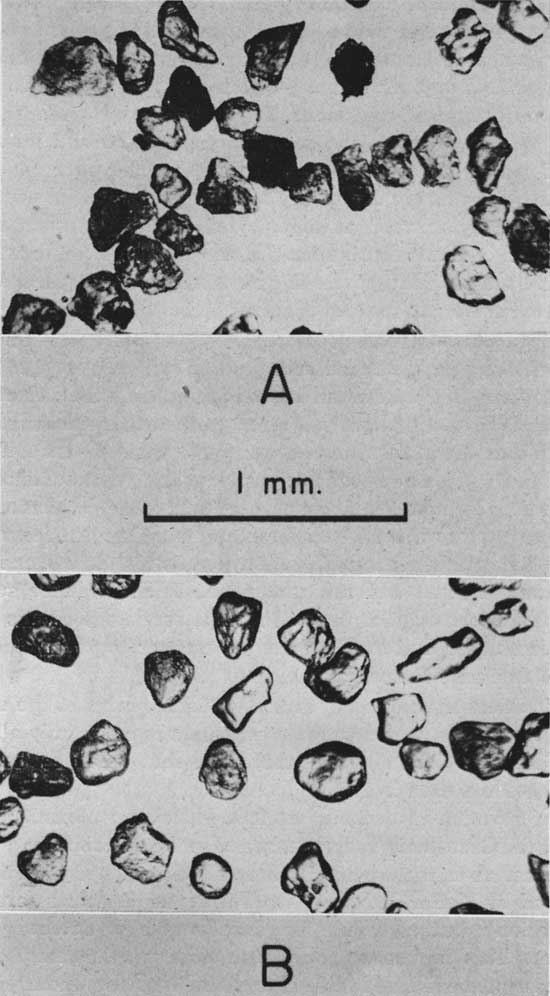
Most of the leucoxene of the Kiowa consists of yellowish or brownish, angular, semitranslucent to opaque grains having rough surfaces. Leucoxene exceeds ilmenite by at least 2 to 1 in every sample (Pl. 1) and in a few samples it is more than three times as common as ilmenite.
Staurolite is not common, but a few grains are present in nearly every sample, and the grains are large and irregular in outline. Many of them have "concertina" boundaries, owing probably to solution. Pleochroism is marked (X = pale yellow or colorless; Z = russet brown).
Garnet occurs in most samples, but its concentration is less than 2 percent. All the garnet in the Kiowa is colorless. The shape of the grains is irregular, and the surfaces of some grains are pitted.
One or two small grains of reddish-brown rutile occur in most samples.
Titanite occurs as fairly small yellowish-brown grains having clouded interiors; it is present in most samples.
Two varieties of hornblende are present in sands of the Kiowa shale, although their occurrence is rare. Blue-green hornblende was observed in a few samples, but the green variety is more common.
Chlorite minerals were found in all the sands of the Kiowa. We did not attempt to differentiate between the various minerals of the group.
The occurrence of barite is highly variable both in quantity and appearance. There are rounded grains, angular fragments, and particles curved around grains of quartz and other minerals. Some grains are clear; others are clouded with carbonaceous inclusions. Nearly all, if not all, the barite is authigenic; therefore it was not included in the mineral counts.
One or two large, deep purplish-brown, almost opaque grains of anatase having crystal facets or irregular surfaces were found in about one-third of the samples; they are probably authigenic.
Only one grain each of the following minerals was observed; these may have been derived from the Dakota formation. One grain of magnetite was identified by its characteristic dodecahedral crystal form, but occasional tests with a bar magnet did not reveal the presence of any more magnetite. One grain of diopside having dentate ends occurred in cuttings from test hole 15.
The following minerals were lost on acid digest. Calcite and aragonite occurred in shell fragments, cone-in-cone structures, and as cement. Pyrite occurred as cement, massive chunks, radiating masses, and cubes, some of which are striated. Anhydrite seems to have had approximately the same occurrence as that of barite. Impure siderite was present (but not so abundantly as in the Dakota formation) in the form of clay-ironstone or brown ironstone or mudstone.
The light fraction is predominantly quartz including less than 5 percent feldspar, as determined by staining tests (Russell, 1935). The feldspars are largely partly decomposed plagioclase and microcline. Most of the quartz grains are characterized by many fluid and automorphic mineral inclusions whereas acicular inclusions are rare. Chert is present in all the samples, and quartzite fragments occur in most of them.
Muscovite is common in most sands of the Kiowa. It contains varied inclusions; the outlines of the flakes range from well rounded to ragged.
Several rounded, grayish-green particles of glauconite are present in nearly every sample of sand from the Kiowa shale.
Mechanical composition of sands--Sands of the Kiowa shale are uniformly fine-grained; the mean diameters of all except two of the 19 sands analyzed fall within the limits 0.10 to 0.16 mm. One sample, from the base of the Kiowa in test hole 21, is coarser grained, having an average diameter of 0.20 mm, and possibly includes an admixture of the Cheyenne sandstone. The other sample, having a mean diameter not within the specified limits, is a very fine-grained sand from the middle of the Kiowa shale in test hole 19. Its mean diameter is 0.08 mm. The difference in size between the fine sands of the Kiowa and the basal sands of the Dakota formation generally is sharp.
The degree of sorting in the samples is highly variable, and has not been included in the cross sections because sorting values obtained from drill cuttings seem to be meaningless. In many samples, however, the logarithmic standard deviation (Krumbein and Pettijohn, 1938, p. 249f) is 0.5 or smaller. This value means that approximately 68 percent or two-thirds of the frequency distribution lies within one Wentworth grade. This high degree of sorting observed in samples of cable-tool cuttings taken from an interval of 5 feet or more, coupled with the low range in average size of sands of the Kiowa, may indicate uniform conditions of deposition.
Roundness evaluation of sands--With one exception, all the sands of the Kiowa shale showed extreme angularity in quartz grains of the size studied (0.177 to 0.125 mm), where most of the roundness values occur between 0.1 and 0.3 (Pl. 2A). The exception is in cuttings from test hole 20, in which a mixture of rounded and angular grains was found immediately above red shale of Permian age. A similar low degree of roundness was also observed in the tourmaline, ilmenite, leucoxene, and, to some extent, zircon grains.
Plate 2--Photomicrographs of quartz grains of the size range 0.125 to 0.177 mm from the Kiowa shale and Permian redbeds, showing difference in roundness: A, Kiowa shale, test hole 10, depth 472-481 feet; B, Permian redbeds, test hole 8, depth 560-565 feet.
The Dakota-Kiowa contact--The Dakota-Kiowa contact is not a sharp one, nor is it marked by any particular beds having distinctive lithology. The top of the Kiowa shale consists of gray to dark-gray shale in most test holes and fine-grained, micaceous, glauconitic sandstone in others. Fire tests on the gray shale below the basal sandstone of the Dakota forma-,ion show complete gradation from a dense, moderately light-firing material at the top to a dark, bloated clinker within about 20 feet. This gradation probably is due to surface weathering of the Kiowa shale before deposition of the Dakota formation (Plummer, oral communication); therefore, even though the light-firing clay is regarded by Plummer as typical of the Dakota formation, we have included it with the Kiowa in holes where it was found to grade into unquestioned Kiowa shale.
Diagnostic criteria for identification--The Kiowa shale is a lithologic unit consisting of gray to black shale, light siltstone, and fine-grained, angular, micaceous, glauconitic sandstone. It differs from the overlying Dakota formation in the absence of coarse sand, siderite pellets, and red clay, and in the presence of shell fragments, abundant pyrite, and cone-in-cone structures. Its outstanding distinguishing characteristic is the presence of thick beds of dark-gray, thinly laminated shale.
Cheyenne Sandstone
General features--The Cheyenne sandstone is predominantly buff to light-gray sandstone containing a small amount of shale and siltstone; in the area studied it ranges in thickness from a featheredge to 62 feet. In north-central Ellis County, west of this area, the formation attains a maximum thickness of more than 200 feet (Frye and Brazil, 1943, p. 17), and immediately east of the area studied the Cheyenne is reported to be absent. The Cheyenne sandstone unconformably overlies the Permian redbeds and is overlain by the marine Kiowa shale.
Mineralogy--Heavy minerals identified in 51 samples from the Cheyenne sandstone include the following species: zircon, tourmaline, ilmenite, leucoxene, staurolite, garnet, rutile, titanite, hornblende, barite, purplish-brown anatase, chlorite, and one or two grains each of topaz, pleonaste, and kyanite (Table 3). Several grains of an unidentified colorless biaxial mineral having high refractive indices were observed, two grains of which were also found in the Kiowa.
The heavy mineral suite consists predominantly of zircon, tourmaline, ilmenite, and leucoxene, as in the sands of the Kiowa shale, except that the amount of ilmenite in many samples from the Cheyenne exceeds that of leucoxene (Pl. 1). All varieties of tourmaline found in samples from the Kiowa occur also in the Cheyenne. In addition there are parti-colored grains in combinations of green and blue; green and yellow; green, blue, and brown; yellow and blue; and brown and blue. Garnet occurs in the colorless form and also in a pink variety.
In the facies of the Cheyenne sandstone in which the quartz grains are predominantly angular the heavy mineral suite is somewhat similar to that in the sands of the Kiowa shale, except that chlorite is less common than in the Kiowa.
The samples in which the quartz grains are predominantly rounded are characterized by the same restricted mineral suite as that of the typical Permian sands--zircon, tourmaline, ilmenite, leucoxene, staurolite, rutile, garnet, and authigenic barite. There are fewer angular and prismatic grains of tourmaline in this type of Cheyenne sandstone than in the sandstones of the Kiowa shale and the tourmalines are predominantly brown instead of green. The leucoxenes and ilmenites are also well rounded, and a large proportion of the leucoxenes have the porcelanous texture typical of leucoxene in the Permian sands. As in the Permian, the leucoxene-ilmenite ratio is less than unity in the rounded sands, except in cuttings from the test holes south of the city of Russell, where the ratio is more nearly the same as it is in the Kiowa (Pl. 1), although the ilmenite and leucoxene from these test holes are of the Permian type.
Calcite, pyrite, anhydrite, siderite, and hematite were lost when the samples were treated with acid. Calcite occurred as interstitial material in cuttings from a few test holes. The occurrence of pyrite was similar to that in the Kiowa shale except that pyrite was much less common in the Cheyenne sandstone encountered by the western test holes than in the Kiowa or in the Cheyenne encountered by the eastern holes. Anhydrite was common. Impure siderite was present in the same form as in the Kiowa shale, and impure hematite in the form of red ironstone was associated with it. Siderite and hematite were more common in cuttings from the eastern group of test holes.
In the Cheyenne sandstone, as in the Kiowa shale, the light fraction is predominantly quartz and includes less than 5 percent feldspar. The angular quartz grains are similar in appearance to those of the Kiowa. Some of the quartz grains in the rounded group are without inclusions of any kind, and others are characterized by parallel and subparallel bands of fluid inclusions. In general, inclusions in the rounded grains are fewer than in quartz grains of the Kiowa. Automorphic and acicular mineral inclusions are rare. The surfaces of the grains in the rounded group are commonly frosted or pitted. In both groups a few of the grains exhibit undulatory extinction, as do a few of the grains of quartz and muscovite in the Kiowa. Muscovite is rare in the Cheyenne. Chert is present in all the samples, and quartzite is present in most of them. Glauconite is present in many samples, but it is not as common as in the Kiowa.
Mechanical composition of sands--Those samples of Cheyenne sandstone in which the grains are predominantly rounded range in average size from 0.08 to 0.24 mm. In most of the test holes the' grain size of the lowermost sample of the Cheyenne sandstone is slightly coarser than that of the Permian material immediately underlying it. The geometric mean diameter of the angular facies of the Cheyenne sandstone is much more uniform, ranging from 0.15 to 0.20 mm. This range is uniformly larger than the mean diameter of the sands of the Kiowa shale.
Roundness evaluation of sands--On the basis of roundness, the Cheyenne sandstone may be subdivided into two types. One type has the low degree of roundness of the sands of the Kiowa shale, and the other type has the moderately high roundness of the underlying sands of the Permian beds. In the latter type, most of the roundness values of the size studied (0.177 to 0.125 mm) occur between 0.4 and 0.6. Some samples consist of mixtures of rounded and angular grains. The areal distribution and significance of the two types of sand in the Cheyenne will be discussed in the sections on lateral changes and depositional environment.
The Kiowa-Cheyenne contact--In most of the test holes the Kiowa-Cheyenne contact was found to be marked by a sharp change from fine-grained, micaceous, angular sand to medium- or fine-grained, non-micaceous sand which may be either angular or rounded. In a few test holes the top of the non-micaceous sand was found to occur at the base of dark-gray or black Kiowa shale.
Diagnostic criteria for identification--As work on the sand samples progressed, it became evident to us that the Cheyenne sandstone is comprised not only of sand from an immediate source (the underlying sandstones of the Permian) but also from a more distant region, which probably also supplied sand to the Kiowa shale. In parts of the area the sands in the Cheyenne were derived entirely from the Permian redbeds, but in other parts of the area. the sands in the Cheyenne were derived almost entirely from a different source. It was therefore impossible to use the criterion of grain roundness to differentiate between the Cheyenne sandstone and the Kiowa shale, and comparative mineralogy was found to be useful only where it reflected the conditions under which the sand was deposited. As most of the beds of sandstone which are unquestionably part of the Kiowa shale consist of white, fine-grained, micaceous, glauconitic sand and silt, and as marine shell fragments do not occur below the lithologic unit comprised by these beds of sand and the dark Kiowa shale, we have included the material below the micaceous sand and dark shale and above the Permian redbeds in the Cheyenne sandstone. We could find no other definite lithologic break. Another criterion consists of the presence of red ironstone or impure hematite in the Cheyenne and its absence in the fine-grained micaceous sandstone and dark shale of the Kiowa. These criteria are intended for use only in the immediate area with which this report is concerned. Farther southwest the Kiowa shale probably also contains fine sand grains of the rounded type, which were transported by streams crossing the area of red Permian sands.
Permian Rocks
General features--The Permian redbeds underlying the Cheyenne sandstone and Kiowa shale in Russell County consist of red and white sandstone, red siltstone, and red and gray shale. Beds of sandstone predominate in the western part of the area but are thin to absent farther east. The westward-dipping Cedar Hills sandstone (?) may possibly be truncated in the eastern part of the area, where the Salt Plain formation (?) may be in contact with the Comanchean.
Mineralogy--The heavy mineral suite of typical sand from the Permian redbeds is restricted to zircon, tourmaline, staurolite, rutile, ilmenite, leucoxene, and authigenic barite (Table 2), as described in the section on mineralogy of the rounded sands of the Cheyenne. Garnet, some of which is pink, occurs in about a third of the samples. One or two grains of each of the following were seen: epidote, spinel, hornblende, and anatase. In general, the amount of ilmenite exceeds that of leucoxene. Titanite and chlorite, present in only a few samples, are much more rare than in the Comanchean sands. The heavy mineral content of most of the Permian sands is less than 0.3 percent by weight.
Iron-oxide coating on the grains, fragments of impure hematite, and a variable amount of anhydrite were the major constituents removed during acid-treatment. Pyrite was rare to absent.
In the light fraction, the occurrence of quartz and feldspar is similar to that in the rounded facies of the Cheyenne sandstone. The quartz grains are commonly frosted. One grain of orthoclase surrounded by unworn authigenic feldspar was observed. The occurrence of glauconite is sporadic, and it is not so abundant as in the Kiowa shale. Muscovite is rare in the sand, but a moderate amount is present in some of the silty shale.
Mechanical composition of sands--The average diameter of sands of Permian age in the area studied ranges from 0.08 to 0.22 mm. In general, Permian sands from test holes in the westernmost part of the area are slightly coarser grained than those from test holes in the central part; east of the approximate center of T. 14 S., R. 14 W., the Permian rocks are predominantly red siltstone and red shale. Test hole 20, in the eastern part, penetrated more than 300 feet of uniform brick-red shale and siltstone. At least 165 of the 198 feet of Permian rocks penetrated by test hole 8, one of the westernmost tests, was red sandstone. Such evidence suggests that the eastern edge of the Cedar Hills sandstone occurs within the area studied, but the data are too meager to permit the mapping of a definite boundary line.
Roundness evaluation of sands--Quartz grains of the size for which roundness values were determined are essentially all fairly well rounded (Pl. 2B), and there are few particles having a roundness less than 0.4.
The Permian-Cretaceous contact--The unconformity at the base of the Cretaceous rocks is marked in the outcrops by a weathered zone. A thin zone of weathered and bleached material was observed by McFarland in the drilling of the test holes (oral communication), but as a rule we were unable to detect it in the samples. This failure probably resulted from the finely divided character of the silt and from admixture with the underlying unweathered redrock and overlying gray sandstone and siltstone. McFarland reported the thickness of the zone to be approximately 2 feet, which is comparable with the thickness seen in surface exposures.
In one or two test holes the color change from gray sandstone to red sandstone was found to be gradational within an interval of 10 or 20 feet, and in these tests the placing of the contact was somewhat arbitrary. Frye (oral communication ) has found surface exposures in Kiowa County in which large amounts of red Permian material have been incorporated into the basal beds of the Cheyenne sandstone without loss of color. There is no way known to us to determine from well cuttings whether or not this has occurred in Russell County.
Diagnostic criteria for identification--The outstanding distinguishing characteristic of the Permian redbeds is their red color. Although on the basis of roundness and mineralogy they can be distinguished from the sands of the Kiowa shale and angular facies of the Cheyenne sandstone, the red color and the associated scarcity of pyrite are the only features determinable by us which serve to differentiate between the Permian sands and the rounded facies of the Cheyenne.
Table 2--Mechanical analyses of sand samples from test holes in Russell County. (By Carrie B. Thurber)
| Test hole |
Depth (feet) |
Geologic subdivision |
Mechanical Analysis (percent by weight) | |||||||||
|---|---|---|---|---|---|---|---|---|---|---|---|---|
| Fine gravel (1.41- 1.0 mm) |
Coarse sand | Medium sand | Fine sand | Very fine sand | Silt and clay (less than 0.062 mm) |
|||||||
| (1.0- 0.71 mm) |
(0.71- 0.50 mm) |
(0-50- 0.35 mm) |
(0.35- 0.25 mm) |
(0.25- 0.177 mm) |
(0.177- 0.125 mm) |
(0.125- 0.088 mm) |
(0.088- 0.062 mm) |
|||||
| 8 | 518-28 | Cheyenne | 1.9 | 48.1 | 30.5 | 13.3 | 4.9 | 0.8 | 0.5 | |||
| 8 | 540-45 | Permian | .9 | 21.4 | 26.3 | 32.9 | 14.0 | 2.8 | 1.6 | |||
| 9 | 487-97 | Kiowa | 0.0 | .0 | .1 | .6 | 32.7 | 47.1 | 13.1 | 6.4 | ||
| 9 | 580-85 | Permian | 1.0 | 3.9 | 17.5 | 24.5 | 18.6 | 29.5 | ||||
| 10 | 472-81 | Kiowa | .5 | 1.6 | 12.9 | 27.9 | 26.5 | 20.1 | 10.5 | |||
| 10 | 505-15 | Cheyenne | .1 | 3.5 | 18.3 | 42.9 | 21.2 | 10.6 | 3.5 | |||
| 10 | 560-70 | Permian | .0 | 2.9 | 31.2 | 30.0 | 18.1 | 12.3 | 5.4 | |||
| 11 | 305-15 | Dakota | 12.0 | 47.6 | 21.0 | 10.1 | 3.5 | 1.7 | 4.0 | |||
| 11 | 400-10 | Kiowa | .2 | .9 | 1.2 | 4.2 | 21.6 | 38.5 | 13.2 | 20.2 | ||
| 11 | 457-65 | Permian | 1.2 | 10.6 | 22.8 | 32.6 | 19.3 | 13.5 | ||||
| 12 | 418-23 | Kiowa | .4 | 1.7 | 30.6 | 45.4 | 13.0 | 5.2 | 3.7 | |||
| 12 | 428-33 | Cheyenne | .3 | 1.7 | 13.5 | 39.9 | 27.1 | 10.0 | 7.6 | |||
| 13 | 415-20 | Kiowa | .5 | 2.9 | 18.8 | 44.1 | 22.9 | 5.8 | 5.1 | |||
| 13 | 445-54 | Cheyenne | .4 | 16.8 | 47.2 | 29.6 | 4.1 | 1.0 | 0.9 | |||
| 14 | 320-25 | Kiowa | 0.1 | 0.1 | .1 | .6 | 4.5 | 27.7 | 51.1 | 10.5 | 2.4 | 2.9 |
| 14 | 415-20 | Cheyenne | .4 | 3.3 | 8.7 | 20.1 | 37.6 | 15.4 | 6.7 | 7.8 | ||
| 17 | 195-205 | Dakota | .4 | 4.2 | 17.3 | 31.5 | 33.8 | 9.1 | 1.8 | 1.9 | ||
| 17 | 375-80 | Cheyenne | .2 | 3.5 | 50.4 | 35.8 | 6.9 | 1.7 | 1.6 | |||
| 17 | 425-30 | Permian | 1.0 | 11.0 | 36.5 | 42.5 | 6.7 | 1.7 | 0.7 | |||
| 18 | 420-25 | Cheyenne | 1.6 | 24.7 | 27.2 | 25.6 | 17.3 | 2.7 | 1.0 | |||
| 18 | 440-45 | Permian | .4 | 11.1 | 21.7 | 35.5 | 26.0 | 3.0 | 2.3 | |||
| 19 | 460-65 | Cheyenne | .3 | 8.9 | 37.1 | 29.7 | 19.9 | 2.3 | 1.8 | |||
| 19 | 485-95 | Permian | 0.9 | 1.2 | 1.6 | 1.8 | 5.3 | 25.4 | 37.4 | 15.6 | 5.1 | 5.7 |
| 20 | 380-85 | Dakota | .6 | .9 | 6.2 | 28.4 | 29.8 | 22.8 | 7.5 | 2.2 | 1.6 | |
| 21 | 375-80 | Dakota | .5 | 3.9 | 9.8 | 18.4 | 38.1 | 17.2 | 6.1 | 6.0 | ||
| 21 | 485-90 | Kiowa | .2 | .5 | 10.3 | 29.6 | 22.8 | 20.5 | 10.5 | 2.6 | 2.9 | |
| 21 | 500-05 | Cheyenne | .3 | 4.8 | 12.2 | 16.6 | 32.9 | 22.4 | 5.6 | 5.2 | ||
| 21 | 540-45 | Permian | 1.7 | 9.5 | 11.0 | 24.1 | 30.6 | 10.8 | 12.2 | |||
| 22 | 260-65 | Dakota | .3 | .8 | 3.6 | 39.0 | 36.4 | 9.2 | 10.6 | |||
| 22 | 310-15 | Kiowa | .4 | 1.3 | 43.3 | 36.9 | 7.0 | 11.1 | ||||
| 22 | 330-35 | Cheyenne | .7 | 9.1 | 11.6 | 29.2 | 39.8 | 5.6 | 3.9 | |||
| 22 | 360-65 | Permian | .1 | 11.6 | 21.6 | 29.9 | 30.1 | 4.4 | 2.3 | |||
| 23 | 480-85 | Cheyenne | .4 | 4.8 | 22.4 | 32.4 | 30.7 | 5.7 | 3.6 | |||
| 24 | 436-40 | Cheyenne | .3 | 1.4 | 3.0 | 14.7 | 41.4 | 33.4 | 4.5 | .8 | .5 | |
Table 3--Heavy mineral frequencies in cuttings from sands of the Kiowa and Cheyenne formations and the Permian redbeds, expressed as percentages. * = Trace
| Test hole no. |
Inclusive depths (feet) |
Ilmenite | Leucoxene | Tourmaline | Zircon | Staurolite | Garnet | Rutile | Titanite | Hornblende | Chlorite | Anatase | Others |
|---|---|---|---|---|---|---|---|---|---|---|---|---|---|
| Kiowa Shale | |||||||||||||
| 8 | 478-88 | 13 | 44 | 17 | 16 | 2 | 1 | 2 | * | 2 | 1 | - | - |
| 8 | 488-98 | 15 | 56 | 15 | 7 | 3 | 1 | 2 | 1 | - | 1 | - | - |
| 9 | 477-87 | 30 | 36 | 9 | 18 | 2 | 1 | 1 | - | 1 | 1 | - | * |
| 9 | 487-97 | 24 | 33 | 5 | 30 | 2 | 1 | * | 1 | * | 3 | - | * |
| 10 | 472-81 | 15 | 47 | 12 | 23 | * | * | - | * | - | 1 | - | - |
| 10 | 481-86 | 17 | 48 | 10 | 22 | 1 | 1 | * | - | - | 1 | - | - |
| 11 | 390-400 | 18 | 50 | 13 | 14 | 1 | - | 1 | - | * | 2 | - | - |
| 11 | 400-10 | 19 | 49 | 10 | 12 | 2 | 1 | 1 | * | 1 | 5 | - | - |
| 12 | 418-25 | 15 | 42 | 11 | 24 | 1 | 1 | 1 | * | 2 | 4 | - | - |
| 13 | 410-15 | 16 | 43 | 10 | 24 | 2 | - | 1 | 2 | 2 | 3 | - | - |
| 13 | 415-20 | 17 | 45 | 12 | 17 | 4 | * | 1 | 2 | 1 | 3 | - | - |
| 13 | 420-25 | 21 | 36 | 8 | 27 | 2 | 1 | 1 | 1 | 1 | 2 | 1 | - |
| 13 | 425-30 | 16 | 46 | 14 | 17 | 2 | * | * | 1 | * | 2 | - | - |
| 14 | 320-25 | 20 | 33 | 10 | 26 | 4 | 1 | 2 | 2 | * | * | 1 | 1 |
| 15 | 400-20 | 9 | 55 | 11 | 19 | 1 | * | 1 | 1 | * | 2 | 1 | - |
| 15 | 440-45 | 7 | 60 | 16 | 1 | 7 | 1 | * | - | * | 4 | * | * |
| 19 | 405-10 | 8 | 54 | 11 | 22 | * | * | 1 | 1 | - | 2 | - | - |
| 19 | 410-15 | 13 | 40 | 5 | 36 | - | * | * | 1 | * | 1 | * | 1 |
| 21 | 405-10 | 14 | 46 | 12 | 22 | 3 | * | 1 | 2 | - | * | - | - |
| 21 | 480-85 | 18 | 50 | 10 | 18 | 1 | * | 1 | 1 | - | 1 | * | - |
| 21 | 485-90 | 16 | 45 | 8 | 23 | 3 | 1 | 1 | 2 | * | 1 | 1 | - |
| 22 | 300-05 | 13 | 41 | 11 | 29 | 2 | 1 | 2 | * | - | 1 | - | - |
| 22 | 305-10 | 12 | 53 | 8 | 20 | 1 | * | 1 | 2 | - | 2 | - | * |
| 22 | 310-15 | 11 | 55 | 12 | 14 | 2 | 1 | 1 | 3 | * | * | - | * |
| Cheyenne Sandstone | |||||||||||||
| 8 | 498-508 | 53 | 17 | 12 | 14 | 2 | - | 2 | * | - | * | - | - |
| 8 | 508-18 | 44 | 24 | 14 | 13 | 3 | - | * | - | - | - | - | - |
| 8 | 518-28 | 55 | 13 | 17 | 11 | 2 | - | - | * | * | - | - | - |
| 8 | 528-35 | 49 | 29 | 11 | 10 | 1 | - | - | - | - | * | - | - |
| 9 | 532-37 | 34 | 30 | 7 | 26 | 1 | - | * | 1 | - | 1 | - | - |
| 10 | 500-05 | 24 | 43 | 10 | 21 | 2 | * | * | - | - | - | - | - |
| 10 | 505-15 | 49 | 27 | 8 | 15 | 2 | - | - | - | - | - | - | - |
| 10 | 515-20 | 48 | 19 | 10 | 23 | 1 | - | - | - | - | - | - | - |
| 11 | 420-30 | 15 | 55 | 14 | 14 | 2 | - | - | - | - | 1 | - | - |
| 12 | 423-28 | 21 | 29 | 22 | 23 | 3 | * | 1 | 1 | * | * | - | * |
| 12 | 433-38 | 13 | 49 | 19 | 16 | 1 | - | 1 | * | * | * | - | * |
| 12 | 438-43 | 21 | 33 | 18 | 21 | 3 | * | 2 | 1 | 1 | 2 | - | - |
| 13 | 445-54 | 17 | 49 | 15 | 13 | 2 | 2 | - | 1 | * | * | - | 1 |
| 13 | 454-61 | 7 | 43 | 18 | 24 | 2 | 3 | - | 1 | 2 | 1 | - | * |
| 13 | 461-64 | 6 | 42 | 14 | 34 | * | * | 1 | 1 | * | 1 | - | - |
| 14 | 420-25 | 23 | 37 | 7 | 28 | 1 | 1 | 1 | - | - | 2 | 1 | - |
| 15 | 445-50 | 16 | 52 | 8 | 13 | 8 | - | * | 1 | * | 1 | 1 | - |
| 15 | 450-55 | 17 | 37 | 14 | 20 | 7 | * | 1 | * | - | 1 | 2 | 1 |
| 15 | 455-60 | 23 | 33 | 14 | 25 | 4 | * | * | 1 | - | - | - | - |
| 15 | 460-65 | 28 | 32 | 13 | 21 | 2 | - | 2 | 1 | - | - | * | - |
| 16 | 480-85 | 22 | 43 | 14 | 16 | 2 | * | 1 | * | - | - | - | * |
| 16 | 485-90 | 12 | 57 | 16 | 13 | 1 | * | * | * | - | - | - | - |
| 17 | 365-70 | 17 | 36 | 13 | 25 | 4 | 1 | 1 | 1 | 1 | 2 | - | * |
| 17 | 370-75 | 18 | 39 | 11 | 20 | 5 | 2 | 1 | 1 | * | 2 | * | - |
| 17 | 375-80 | 16 | 50 | 11 | 10 | 9 | - | - | 1 | * | * | 1 | - |
| 17 | 380-85 | 25 | 42 | 5 | 21 | 3 | - | * | 1 | - | 1 | - | 1 |
| 17 | 385-90 | 12 | 36 | 10 | 25 | 12 | 2 | 1 | - | 1 | * | * | * |
| 18 | 410-15 | 35 | 35 | 11 | 14 | 3 | * | * | - | - | * | * | 1 |
| 18 | 415-20 | 44 | 36 | 6 | 12 | 2 | - | * | * | - | - | - | - |
| 18 | 420-25 | 36 | 36 | 10 | 17 | * | - | * | * | - | - | - | - |
| 18 | 425-30 | 21 | 42 | 22 | 9 | 4 | - | - | * | - | - | * | - |
| 19 | 445-50 | 33 | 30 | 10 | 24 | 1 | 1 | * | - | - | 1 | * | - |
| 19 | 450-55 | 39 | 28 | 10 | 18 | 4 | - | - | * | - | - | - | - |
| 19 | 455-60 | 30 | 35 | 12 | 18 | 4 | * | * | - | - | - | * | - |
| 19 | 460-65 | 26 | 39 | 10 | 19 | 3 | 1 | - | * | - | 2 | - | - |
| 19 | 465-70 | 27 | 44 | 8 | 15 | 2 | * | 1 | * | - | - | * | 1 |
| 19 | 470-75 | 23 | 42 | 10 | 16 | 6 | 1 | * | * | - | * | - | * |
| 21 | 490-95 | 18 | 48 | 8 | 18 | 3 | 1 | - | 2 | * | - | * | - |
| 21 | 495-500 | 13 | 46 | 13 | 20 | 4 | * | * | * | - | * | 1 | - |
| 21 | 500-05 | 17 | 43 | 9 | 22 | 1 | 1 | * | 1 | 1 | 2 | 2 | - |
| 21 | 505-10 | 19 | 50 | 8 | 18 | * | * | * | 1 | * | 3 | - | - |
| 21 | 510-15 | 26 | 33 | 17 | 18 | 3 | - | 2 | 1 | - | - | - | - |
| 21 | 525-30 | 47 | 28 | 7 | 14 | 3 | - | * | * | - | * | - | - |
| 21 | 530-35 | 47 | 24 | 11 | 12 | 3 | - | * | - | - | - | - | - |
| 22 | 330-35 | 57 | 16 | 6 | 17 | 3 | - | - | - | - | - | - | - |
| 22 | 335-40 | 50 | 21 | 11 | 16 | 1 | - | * | - | * | - | - | - |
| 22 | 340-45 | 52 | 20 | 7 | 18 | 2 | - | * | * | - | - | - | - |
| 22 | 345-50 | 56 | 18 | 10 | 15 | 1 | - | * | - | - | - | - | - |
| 22 | 350-55 | 47 | 29 | 11 | 12 | 1 | - | - | - | - | - | - | - |
| 22 | 355-60 | 42 | 34 | 10 | 10 | 1 | * | * | - | - | - | - | - |
| 24 | 436-45 | 18 | 50 | 9 | 10 | 5 | 2 | - | - | - | 1 | 1 | 2 |
| Permian Redbeds | |||||||||||||
| 8 | 535-40 | 53 | 15 | 8 | 22 | 2 | - | - | - | - | - | - | - |
| 8 | 540-45 | 47 | 21 | 13 | 16 | 2 | - | - | - | - | * | - | - |
| 8 | 545-50 | 60 | 17 | 7 | 15 | 1 | - | * | - | - | - | - | - |
| 8 | 550-55 | 52 | 17 | 13 | 15 | 3 | - | * | * | - | * | - | - |
| 9 | 537-42 | 35 | 32 | 10 | 20 | 1 | - | - | 2 | - | * | - | - |
| 9 | 542-50 | 98 | 68 | 3 | 26 | 2 | 1 | 1 | 1 | - | - | - | - |
| 9 | 550-60 | 36 | 36 | 5 | 19 | 2 | - | * | 1 | - | 1 | - | - |
| 10 | 520-30 | 44 | 28 | 12 | 15 | 1 | - | - | - | - | - | - | - |
| 10 | 540-50 | 39 | 34 | 7 | 19 | * | - | - | - | - | - | - | - |
| 11 | 457-65 | 22 | 38 | 11 | 25 | 1 | 1 | 1 | * | - | * | - | * |
| 11 | 465-75 | 27 | 43 | 12 | 14 | 1 | 1 | * | 1 | * | - | - | * |
| 11 | 475-80 | 28 | 41 | 14 | 13 | 2 | 1 | * | 2 | - | - | - | - |
| 11 | 480-85 | 21 | 42 | 14 | 16 | 3 | 2 | 1 | 1 | 1 | * | - | - |
| 18 | 430-35 | 49 | 30 | 8 | 13 | * | * | - | - | - | - | - | - |
| 18 | 435-40 | 49 | 22 | 9 | 17 | 2 | * | * | - | - | - | - | - |
| 18 | 455-60 | 44 | 26 | 6 | 22 | 1 | - | 1 | - | - | - | - | - |
| 18 | 465-70 | 42 | 32 | 10 | 15 | * | - | - | - | - | - | - | - |
| 19 | 475-85 | 33 | 34 | 10 | 18 | 2 | * | 1 | 1 | - | - | - | - |
| 19 | 485-95 | 34 | 36 | 10 | 15 | 2 | * | 2 | 1 | - | - | - | - |
| 19 | 510-16 | 44 | 27 | 7 | 19 | 1 | * | 1 | - | - | * | - | - |
| 21 | 535-40 | 50 | 20 | 13 | 14 | 3 | - | - | - | - | - | - | - |
| 21 | 540-45 | 58 | 16 | 5 | 21 | * | - | - | - | - | - | - | - |
| 21 | 545-50 | 46 | 29 | 8 | 14 | 2 | - | 1 | - | - | 1 | * | - |
| 22 | 360-65 | 41 | 33 | 5 | 19 | 2 | - | * | - | - | - | - | - |
| 22 | 365-70 | 47 | 32 | 6 | 12 | 1 | - | - | * | - | - | - | - |
| 22 | 370-75 | 51 | 23 | 9 | 13 | 2 | - | * | * | - | - | - | - |
| 22 | 375-80 | 50 | 28 | 7 | 13 | 1 | - | * | * | - | - | - | - |
| 22 | 380-85 | 39 | 33 | 10 | 15 | 1 | - | 1 | - | - | - | * | - |
| 22 | 385-90 | 40 | 35 | 12 | 11 | 1 | - | * | - | - | - | - | - |
| Test hole no. |
Inclusive depths (feet) |
Ilmenite | Leucoxene | Tourmaline | Zircon | Staurolite | Garnet | Rutile | Titanite | Hornblende | Chlorite | Anatase | Others |
Lateral Changes in Thickness and Character of the Kiowa and Cheyenne Formations
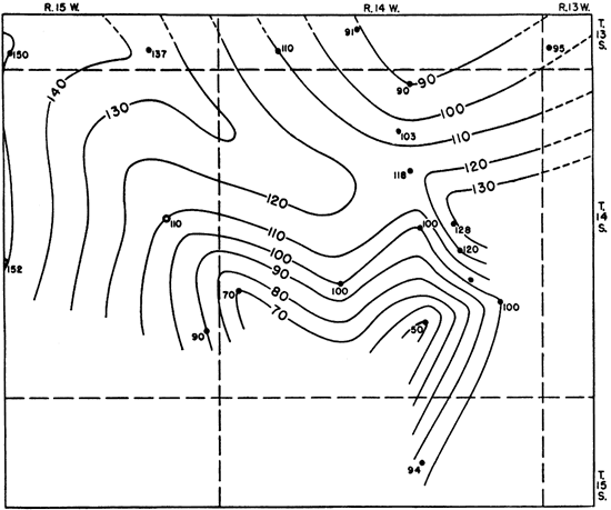
The Kiowa shale attains its greatest thickness in the northwestern part of the area, where it reaches a maximum of 105 feet in test hole 21. The formation gradually thins toward the east and southeast, where a minimum thickness of 50 feet occurs in test holes 18 and 20. Figure 3 is an isopachous map of the formation.
Figure 3--Map of part of Russell County, Kansas, showing changes in thickness of the strata between the base of the Dakota formation and the base of the Kiowa shale.
We were unable to trace any persistent lithologic zones within the Kiowa shale, although a fine-grained, micaceous sandstone, 5 to 30 feet thick, was found in the middle of the formation in several test holes. Micaceous sandstone occurred at the base of the formation in the northwestern test holes and was found to thin westward from 35 feet in test hole 10 to 10 feet in test hole 21. This basal sandstone was not encountered elsewhere except in test holes 12 and 15. Shell fragments were most abundant in samples from test holes south of the city of Russell. Fragments of cone-in-cone structures were present in samples of the Kiowa from test holes 13, 16, and 24.
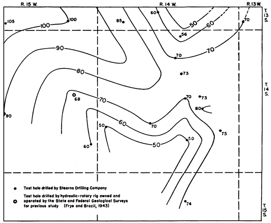
The thickest occurrence of the Cheyenne sandstone in the area was penetrated by test hole 5 of the report by Frye and Brazil (1943). The formation thins toward the southeast and northeast (Fig. 4), where its thickness is 20 feet and less, and thickens to 55 feet in test hole 12, south of Russell in the east-central part of the area. The Cheyenne sandstone encountered in test holes 8, 9, 11, 18, and 22 was found to consist almost wholly of rounded grains of the Permian type. In test holes 10, 15, and 16, the top part of the formation was found to contain angular sand like that of the Kiowa except for its larger grain size and absence of mica. There is an abrupt transition to rounded sand below. The degree of roundness is variable in cuttings from the remaining test holes.
Figure 4--Map of part of Russell County, Kansas, showing changes in thickness of the strata between the top of Permian redbeds and the base of the Kiowa shale. For explanation see Figure 3.
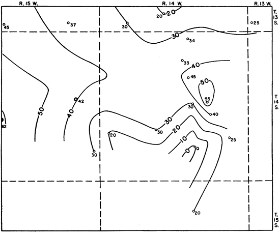
Figure 5 is an isopachous map of the Comanchean strata from the top of the Kiowa shale to the top of the Permian rocks. Under the assumptions that (1) the Kiowa shale is conformable on the Cheyenne sandstone, (2) the top of the Kiowa shale was a nearly flat surface at the close of Kiowa deposition, and (3) pre-Dakota erosion was negligible (as it seems to have been in surface exposures), the map becomes a paleotopographic map of the buried Permian surface in Comanchean time. The prominent features are a saddle between two high areas and a valley having a gentle slope downward toward the northwest. The pattern is reflected in the thickness maps of the Cheyenne and Kiowa formations (Figs. 4 and 5). The gradual slope of the Permian surface and the thickening of the Cheyenne sandstone toward the west are clearly illustrated in section AA' (Pl. 1A). Section BB' (Pl. 1B) shows the depression along a general north-south line across the saddle, and the corresponding thickening of the Cheyenne sandstone in the deepest part. The test holes in which the lower part or the entire thickness of the Cheyenne was found to consist largely of rounded sand grains are, with one exception, on the western flank of the Permian high area. The test holes in which the Cheyenne showed the lowest degree of roundness (12 and 17) are in areas east of the Permian "high," where the Permian rocks are composed of red clay and fine silt. Varying degrees of mixture of rounded and angular grains were found in test holes in the saddle and also in no. 21, in the northwest corner of the area. Silt and shale in the Cheyenne were found only in test hole 21 and in test holes in the saddle. Pyrite also was more common in the same test holes. The isopachous maps should not be regarded as accurate representations of fact because of the difficulty of picking contacts in several test holes. However, variation of a few feet in either direction should not significantly alter the general picture. Test hole 8, in which there was much caving, perhaps is not correctly represented in the Permian valley.
Figure 5--Map of part of Russell County, Kansas, showing changes in thickness of the Kiowa shale and Cheyenne sandstone. For explanation see Figure 3.
Depositional Environment of the Cheyenne Sandstone
The features described in the foregoing paragraphs suggest that more than one environment is represented in the Cheyenne sandstone of the area studied. The well-washed, well-sorted sands in the western part of the area were probably eroded from the underlying land surface by waves of an eastward-advancing early Cretaceous sea and deposited along a fairly open shore line, in part cut and planed by wave action. As the sea advanced beyond the edge of the Permian Cedar Hills sandstone (?) and cutting tools became less abundant, the effect of the pre-Cheyenne topography upon the environment may have been more important. The deposits of the Cheyenne associated with the Permian saddle have the following characteristics which may be attributed to deposition in an inlet or estuary: abundant pyrite, suggesting poor circulation of water and reducing conditions; high leucoxene-ilmenite ratios in sands presumably derived from deposits in which leucoxene-ilmenite ratios were low, attributed to "sour" waters by Milner (1940, p. 509); and much shale and silt indicating less vigorous wave action. Shaly and silty samples of the Cheyenne are restricted to the estuary and to the vicinity of the Permian valley which slopes toward the northwest corner of the area (Fig. 5).
The angular sand typical of the Kiowa shale, which in the estuary is mixed with sand locally derived from the Permian beds, is believed to have had its source in the land area to the east and northeast and to have drifted across the Permian saddle after swampy areas east of the saddle had been filled with debris. Currents flowing across the saddle and down the valley in the Permian rocks may have supplied the angular sand observed in test hole 21. The Permian topographic "high" may have prevented the admixture of angular sand with the rounded type in the western part of the area, except in the valley associated with the saddle, until sea level rose above the area.
The low degree of roundness of the sand of the Cheyenne sandstone encountered in test hole 17 probably resulted from the sheltering effect of the shale hill of Permian age to the west, which prevented the accumulation of rounded Permian sands.
The surprising uniformity in average size of the angular facies of the Cheyenne sandstone should be noted. The upper average-size limit may have resulted from a lack of coarse grains in the source material or from their removal during transportation. The small amount of fine material probably resulted from the same wave action that removed the mica. The conclusion follows, then, that if wave action had been significantly less we would automatically have referred the angular sands to the Kiowa shale. Other conditions may have helped to determine the grain size.
The abrupt vertical change to micaceous sand of the Kiowa shale, coincidental with the absence of shell fragments in the underlying material, may indicate a transition from extremely shallow-water conditions and effective wave action, by means of which the mica flakes of the angular facies of the Cheyenne sandstone could have been winnowed out and removed seaward, to the quiescent and typically marine environment of Kiowa time. In this connection the absence of pink garnet and parti-colored (except the brown-and-green variety) tourmaline in the Kiowa is noteworthy, for it indicates that conditions precluded the possibility of the reworking of underlying sands during early Kiowa time. The advent of the Kiowa sea in the area seemingly corresponded to the covering of the Permian ridge or high areas.
The same conditions seem to have prevailed in the outcrop area of the Cheyenne sandstone in Kiowa County. Below the "Champion shell bed," which marks the base of the Kiowa shale in Champion Draw, the beds of sandstone and siltstone consist of fairly well-rounded grains and show marked current bedding. The bedding is horizontal above the shell bed, and any sandstone present is fine-grained, angular, and micaceous.
Conclusions
The Cretaceous formations encountered in drill holes in this area can be distinguished by lithology and stratigraphic position. The chief characteristics used in differentiating between sands of the Kiowa shale and the Cheyenne sandstones are grain size and amount of mica. The Cheyenne sandstone in the area includes material from at least two sources, and it is believed to consist of relatively coarse basal Cretaceous sands and associated deposits wherever they may occur in the immediate region. The eastern edge of the Cheyenne sandstone probably is not in the area studied.
Prev Page--Introduction || Next Page--Quality of Ground Water
Kansas Geological Survey, Geology
Placed on web March 5, 2009; originally published Dec 31, 1945.
Comments to webadmin@kgs.ku.edu
The URL for this page is http://www.kgs.ku.edu/Publications/Bulletins/60_4/03_geol.html