![]()
Prev Page--Contents || Next Page--Geology
Introduction
Purpose of Study
At the request of the Division of Sanitation of the Kansas State Board of Health, a detailed investigation of the subsurface Cretaceous stratigraphy of southwestern Russell County was begun in September 1943 by the State Geological Survey of Kansas, the Division of Ground Water of the United States Geological Survey, and the State Board of Health. The purposes of the study were to determine the eastern boundary and diagnostic features of the Cheyenne sandstone, which is a legal shallow-disposal zone in the oil-field areas of Russell County, and, if possible, to propose criteria for differentiating the Cheyenne sandstone and adjacent beds by examining cuttings with a binocular microscope. The report is limited in scope to discussion of the subsurface geology of the area and the quality of ground water. The investigation was made under the general administration of John C. Frye, acting state geologist, and 0. E. Meinzer, chief of the Division of Ground Water of the Federal Survey, and under the immediate supervision of S. W. Lohman, district geologist of the Federal Survey.
Location and Size of Area
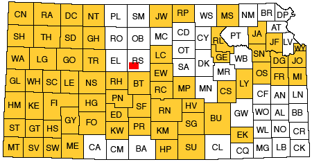
The area discussed in this report is 11 miles long and 9 miles wide and is south and west of the city of Russell in Russell County. It includes T. 14 S., R. 14 W. and parts of T. 13 S., R. 15 W.; T. 13 S., R. 14 W.; T. 13 S., R. 13 W; T. 14 S., R. 15 W.; and T. 15 S., R. 14 W. Its relation to the area studied by Frye and Brazil (1943) and to other areas in Kansas for which cooperative ground-water reports have been published or are in preparation is shown in Figure 1. Oil pools in this area during the test-drilling, program in 1943 were the Donovan, Big Creek, Big Creek East, Big Creek South, Gideon, Rusch, Williamson, Mohl, Smoky Hill, Jerry, and parts of the Gorham, Atherton, Russell, Trapp, and Hall-Gurney (Ver Wiebe, 1944, pp. 74-79).
Figure 1--Index map of Kansas showing area described in this report and areas covered by other online geologic reports, as of March 2009. For additional information, please visit the KGS Geologic Maps of Kansas Page.
Previous Subsurface Geologic Work
One of the first publications touching on subsurface Cretaceous stratigraphy of Russell County appeared about 2 years after the discovery of oil in the area. Twenhofel and Stryker (1925), after studying a group of drillers' logs of Comanchean strata in western Kansas, concluded that "the strata assigned to the Cheyenne show an erratic distribution in harmony with what seems to have been the method and environment of their deposition." Five of the logs were from wells in Russell County, and in four of them no reference was made to the presence or absence of the Cheyenne sandstone. In the fifth well, in sec. 17, T. 12 S., R. 15 W., the authors inferred that the Cheyenne was not present.
Bramlette (1925) published logs of two holes in Russell County, one of which was based upon studies of samples from the Russell County discovery well, the M.M. Valerius Oil and Gas Company No. 1 C.C. Oswald, in the SW SE sec. 8, T. 12 S., R. 15 W. In this log less than 10 feet of sandstone is indicated a few feet above the Permian redbeds; however, Bramlette did not attempt to differentiate between the Dakota, Kiowa, and Cheyenne. The other log reported by him is of the M.M. Valerius Oil and Gas Company No. 1 Phillips well, in the SW SW sec. 3, T. 13 S., R. 13 W., a dry hole. In this log the lowermost 75 feet of Cretaceous deposits is described as limestone and shale.
A recent report by Frye and Brazil (1943) on ground water in the oil-field areas of Ellis and Russell counties includes a description of the character and thickness of the Cretaceous rocks and the approximate location of the eastern edge of the Cheyenne sandstone based on examination of samples from 7 test holes and 35 oil and disposal wells in the area, supplemented by studies of many drillers' logs. Frye and Brazil placed the approximate eastern edge of the Cheyenne along a general north-south line 5 to 7 miles west of U.S. Highway 281 south of Russell in the area discussed in the present report.
Methods of Investigation
A test-drilling program was carried out by the State Board of Health using a cable-tool drilling machine owned and operated by the Stearns Drilling Company. Fourteen test holes were drilled specifically for this investigation under the supervision of John C. McFarland, geologist of the Oil-Field Section of the Kansas State Board of Health, and samples were also obtained from three shallow disposal wells drilled by the Stearns Drilling Company. Fifty-one water samples were collected from 12 of the test holes by McFarland and analyzed by Howard Stoltenberg, chemist in the Water and Sewage Laboratory of the Kansas State Board of Health. Altitudes of the test holes were determined by C. K. Bayne of the Geological Survey. The holes ranged in depth from 400 to 758 feet, and all penetrated Permian redbeds.
Examination of the well cuttings under a binocular microscope was followed by mechanical analyses, roundness evaluations, and studies of "light" and "heavy" fractions from Comanchean and Permian strata using a petrographic microscope. Fire tests were made on a few of the samples of finer grained clastics. J. M. Jewett, Bruce F. Latta, and Thad G. McLaughlin spent a few days with us in Kiowa County collecting sandstone samples from outcrops of the Kiowa shale and Cheyenne sandstone for comparison with the sands from Russell County.
Samples were taken from the bailer at intervals of 5 to 10 feet, and for most intervals two small cloth sample bags were filled in order to provide ample material for analysis. Each large sample of sand of pre-Dakota age and a few samples of sand from the Dakota formation were split in the laboratory with a Jones-type sample-splitter, and half of each was heated with hydrochloric and nitric acids to remove iron-oxide stain, calcite, and pyrite preliminary to determinations of roundness, grain-size, and mineralogy. The other half of each sand sample and the non-sand samples were examined under the binocular microscope. Particular attention was given to the color and surface texture of the grains, to the amount of pyrite, mica, and glauconite present, and to such features as the presence or absence of shell fragments, cone-in-cone structures, calcite cement, clay or silt matrix, siderite pellets from the Dakota formation, and type of "ironstone." Some samples of clay were boiled and washed for examination of the residue.
Approximately 50 grams of each sand sample after acid treatment was screened through sieves of half-Wentworth grades from 4 mm to 0.062 mm in a Ro-Tap sieve shaker for 10 minutes and weighed to the nearest one-hundredth gram. The logarithmic mean size was computed and converted to mean diameter in millimeters, and the results are tabulated in Table 2 and in the cross sections (Pl. 1). Samples which were too small or contained a large amount of shale or more than 50 percent silt by weight were not included. Fracturing of grains during drilling was found to have been negligible, for few of the angular grains associated with the rounder types of sand showed any remnants of rounded surfaces.
About 40 grams of the acid-treated fraction was taken for separation of the "heavy" minerals using bromoform. Heavy and light fractions were split by an Otto microsplit and mounted in Canada balsam. A minimum of 200 grains was counted on each slide of heavy minerals. Percentage occurrences of the heavy minerals, excepting barite, are listed in Table 3. The reader's attention is directed to the fact that the values in the table were derived from examination of well cuttings and are not comparable with mineral frequencies obtained from other types of samples.
In the determinations of roundness, "light" grains of the size range 0.177 to 0.125 mm were mounted under a cover glass on a glass slide in a mixture of one part glycerine to two parts water as suggested by Pye (1943), and the roundness values of a minimum of 50 grains were estimated by means of a visual comparison chart (Krumbein, 1941). The term "roundness" as used by Krumbein follows the practical definition by Wadell (1935), and relates to the degree of sharpness of edges and corners and not to the general shape of the grain. A particle having a roundness value of 0.1 has the sharp edges and general appearance of freshly crushed vein quartz, whereas a grain having a roundness value of 1.0 is without major surface irregularities or indentations.
Measurements were limited to grains of one size grade in order to eliminate the effect of size in comparison of samples. The particular size, 0.177 to 0.125 mm, was chosen because it constituted the major grade of most of the sands in the Kiowa and Cheyenne formations and the Permian rocks. The choice of a larger size would have produced higher roundness values. We did not differentiate between grains of quartz and feldspar in estimating roundness because the low percentage of feldspar could not materially affect the average values and because general observation indicated that the roundness of the feldspar grains was approximately the same as that of the quartz grains. Grains of chert and grains showing secondary growth were not included. The samples were examined by transmitted light under a petrographic microscope.
The roundness data are plotted as histograms in the cross sections (Pl. 1). Each bar represents one-tenth unit in the roundness scale, and the roundness values increase to the right. The final bar on the right-hand end represents the percentage of grains having a roundness value greater than 0.6. Along the vertical scale the distance representing 1 foot in the well log equals 20 percent on the histogram. Thus a histogram having most of the distribution on the left-hand side depicts an angular sand and one having most on the right-hand side depicts a rounded sand, and the general type may be determined at a glance.
In interpreting the results of detailed analyses of sand samples from well cuttings, the possibility of caving and its effects and the possibility of mixing of sands from two or more strata or sedimentation units must be carefully considered. In order to avoid the effects of caving as much as possible, casing was set at the top of some of the Comanchean sands in several of the test holes. At these particular points good samples are reasonably assured. The interpretation of most of the samples, however, requires careful scrutiny of the possibility of contamination from above. Siderite pellets from the Dakota formation in the upper part of the Kiowa shale in a few holes constitute indisputable evidence of caving. Samples from the uppermost 80 feet of the Kiowa shale in test hole 8 consist more largely of red clay and siderite pellets than of Kiowa shale, but this condition is rare. Caving, except from the Dakota, is believed by us to have been negligible for the following reasons: (1) in each test hole the break at the base of the micaceous sand of Kiowa type was fairly sharp; (2) shell fragments from the Kiowa were not found below the base of the formation; (3) although some samples from 5- or 10-foot intervals contain fragments of various lithologic types, some of these samples came from immediately below the bottom of the casing and nearly all were found in a limited area and are believed to be the result of environmental conditions; and (4) with one or two exceptions, no indisputable Comanchean material, such as shell fragments, cone-in-cone structures, or a large proportion of angular sand grains, has been found in samples of Permian rocks. Therefore as caving is demonstrably rare at most key horizons, its effect on the general picture seems to be unimportant.
Mixing of materials from adjacent sedimentation units or adjacent formations is inevitable in well cuttings in which the interval includes parts of both beds, and this fact must be kept in mind when interpretations are drawn from petrographic data. Although most of the data which follow are quantitative in character, it is not our intention to imply exact knowledge of the parameters of the sands which are supposed to have been sampled, but merely to point out general trends and diagnostic characteristics.
The stratigraphy was studied jointly by us, and the chemical analyses of ground water were studied by Swineford. Heavy-mineral analyses were begun by Williams and concluded by Swineford after the transfer of Williams to other work. The final report was prepared by Swineford.
Acknowledgments
Thanks are expressed to several members of the State and Federal Geological Surveys for advice and for assistance in collection of surface samples. We are particularly indebted to John C. Frye for innumerable suggestions and criticisms. The manuscript has been critically reviewed by S. W. Lohman and O. E. Meinzer of the Federal Geological Survey; George S. Knapp, chief engineer of the Division of Water Resources of the State Board of Agriculture; and Paul D. Haney, chief engineer, and Ogden S. Jones and John C. McFarland, geologists, of the Division of Sanitation of the State Board of Health. Excellent samples obtained by 0. G. Stearns of the Stearns Drilling Company under the direction of John C. McFarland made the study possible. Carrie B. Thurber made slides and mechanical analyses of the sandstones. Eileen Martin drafted the illustrations, and Edith H. Lewis edited the manuscript.
Prev Page--Contents || Next Page--Geology
Kansas Geological Survey, Geology
Placed on web March 5, 2009; originally published Dec 31, 1945.
Comments to webadmin@kgs.ku.edu
The URL for this page is http://www.kgs.ku.edu/Publications/Bulletins/60_4/02_intro.html