![]()
Prev Page--Contents || Next Page--Stratigraphy, Pleasanton
Introduction
Ongoing stratigraphic work since the mid-1960's has uncovered enough miscorrelations among well-known Missourian units along the Kansas outcrop belt to necessitate a revision of the nomenclature and classification of parts of the Pleasanton, Kansas City, Lansing and lower Douglas Groups (fig. 1) in this area. The outcrop belt of eastern Kansas and adjacent northwestern Missouri and northeastern Oklahoma contains not only the type region of the Missourian Stage, but also what appears to be the most complete and well-exposed rock succession of this age in the world that is tectonically undisturbed across such a large region. It essentially serves as an informal body stratotype for rocks of this age in the United States, and its completeness will allow it to playa significant role in the selection of Series and Stage boundaries within the Pennsylvanian Subsystem of the Carboniferous System by the Sub-Commission on Carboniferous Stratigraphy (SCCS) of the International Commission on Stratigraphy (ICS). Therefore, it is imperative that the miscorrelations be rectified and the nomenclature reflect the actual stratigraphic relations among the rock units. These modifications to stratigraphic nomenclature and classification also should provide a more consistent framework within which to realistically interpret geologic history and also to adequately address subtle stratigraphic problems involved in resource appraisal and environmental issues.
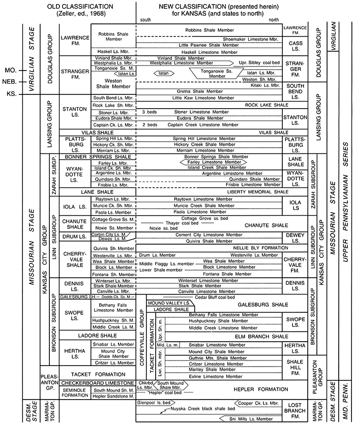
Figure 1--Comparison of old stratigraphic classification of Missourian succession in Kansas (Zeller, ed., 1968), with that revised herein, based on corrections of several long-standing miscorrelations (see figs. 2, 21, 28, 33). Uppercase names are formations or units of higher rank; uppercase and lowercase names are members or beds. Short lines with state abbreviations in upper left show different positions of Missourian-Virgilian Stage boundary currently recognized in those three states. That for Kansas (O'Connor, 1963) was not based on biostratigraphic criteria. Ongoing biostratigraphic work, following the 1983 North American Stratigraphic Code and utilizing mainly conodonts, suggests that the best position for the Desmoinesian-Missourian Stage (and the Middle-Upper Pennsylvanian Series) boundary is at the base of the Exline Limestone (Heckel, Boardman and Barrick, 2002) rather than the base of the Mound City Shale (Barrick et al., 1996), and that the best position for the Missourian-Virgilian boundary may be within the Haskell Limestone (Boardman et al., 1989; Barrick et al., 1995; Heckel et al., 1999). More members are recognized in the Shale Hill Formation above the Mantey Shale Member in Missouri (see figs. 2, 6). [An Acrobat PDF version of this figure is available.]
Much of the information presented here was extracted and updated from a comprehensive analysis of Missourian stratigraphy prepared by P. H. Heckel (available as Kansas Geological Survey Open-file Report 92-60), an informal report that provides more detailed discussion of the history of nomenclature of the units, more elaboration of the problems that have arisen with lateral tracing of some units along outcrop, locations of more reference sections that help to clarify our increasingly refined understanding of the stratigraphy, more discussion of interpretation of the genesis of the units, and more thorough discussion of biostratigraphic correlations of units within Kansas and with units in adjacent states. Concurrent stratigraphic studies at the Kansas Geological Survey, primarily in the subsurface of Kansas, have utilized thousands of wire line logs and over 100 cores, many adjacent to surface exposures, to substantiate the results of these surface investigations.
In order to rectify the miscorrelations, the lithostratigraphic framework of the succession in this area is modified in accordance with the procedure of the North American Stratigraphic Code (North American Commission on Stratigraphic Nomenclature, 1983, available online). The philosophy of this revision follows two additional basic guidelines appropriate to this particular succession of rocks.
The first guideline is to change the nomenclature currently in use in Kansas (and in many cases in the other states along the midcontinent outcrop belt: Missouri, Iowa, Nebraska, and Oklahoma) as little as possible beyond that which is mandated by the rectification of the miscorrelations. In some cases, this requires setting up new reference sections, including neostratotypes in place of original type sections of several familiar units (Hertha, Wea, Hepler). The names have become familiarly associated with strata consistently across the rest of the midcontinent that do not (or may not) correlate with the original type sections. This procedure tempers Article 8e of the North American Stratigraphic Code (1983) on the immutability of stratotypes, with Article 7c regarding the preferability of preserving well-established names. Precedence for this procedure in the midcontinent Missourian lies in the discovery by Newell (1935, p. 74) that the original type section of the Stanton Limestone in Kansas is equivalent to the slightly later named Plattsburg Limestone in Missouri. Common usage of the name Stanton was shifted to a higher limestone because of miscorrelation between the type sections. In his pragmatic resolution of the problem, Newell recognized the higher limestone in the Stanton type area as type Stanton Limestone, rather than replacing the name Plattsburg with Stanton, or the name Stanton with a little-used name from southern Kansas. In other cases, slight to moderate revisions of formations, boundaries, and component members are required to adequately characterize the stratigraphic relations of the units as now understood.
The second guideline is to select lithic boundaries that are required to define the basic lithostratigraphic units (formation, member) as close to significant sequence-stratigraphic (allostratigraphic, cyclothemic) boundaries, such as exposure surfaces and major marine flooding surfaces, as is reasonably possible in order to allow the familiar lithostratigraphic terminology to be easily utilized in modem discussions of genesis of the succession (Watney et al., 1989; Heckel, 1994, 2002; Heckel et al., 1999). This permits discrete unambiguous names to be applied to individual, predominantly marine units across much or all of the midcontinent and provides an appropriate format for correlation at all scales. Lateral continuity of the marine units (regardless of lithic changes within them) underpins correlation within the midcontinent basin and provides the framework for detailed correlations with coeval successions in other basins. The principles behind this guideline were discussed and utilized by Moore (1936, p. 20ff; see also Newell, 1935), and are sanctioned in Article 23e of the 1983 Code (p. 858): "Correspondence with genetic units.--The boundaries of lithostratigraphic units should be chosen on the basis of lithic changes and, where feasible, to correspond with the boundaries of genetic units, so that subsequent studies of genesis will not have to deal with units that straddle formal boundaries." This guideline is readily applied in cases where the entirely marine units (e.g., Swope Limestone) consist of a widespread transgressive limestone, offshore condensed-interval shale, and regressive limestone (see Heckel, 1994), which are lithically distinct from the underlying and overlying terrestrial-to-nearshore shales (e.g., Elm Branch Shale, Galesburg Shale). It is relatively straightforward in cases where the transgressive limestone is missing along much of the outcrop (e.g., Dennis Limestone, Dewey Limestone) because the dark phosphatic, offshore, condensed-interval shale members (Stark Shale, Quivira Shale) provide good lithic markers that tend to be distinct from the underlying lighter terrestrial shale to paleosol (Galesburg Shale, Nellie Bly Formation). In the subsurface the dark phosphatic shales show up conspicuously as positive spikes on gamma-ray logs. This type of boundary at the base of the dark shale is typically at or close to the genetically significant major marine flooding surface (Watney et al., 1989, 1995).
The second guideline is less easily applied where the regressive limestone is missing along most of the outcrop. In such cases, the offshore condensed-interval shale grades more transitionally upward into nearshore marine strata, in places coarser detrital deposits, and ultimately into similar terrestrial deposits that typically are difficult to distinguish from the marine regressive sequence. In these cases, it is just as important to separate the marine transgressive to condensed-interval highstand units, which contain most of the fossils useful for distant correlation (conodonts, ammonoids) from the thicker marine regressive deposits and the similar-appearing lowstand terrestrial detrital units that may contain palynomorphs or other terrestrial fossils of distinctly later age. The most useful procedure is to choose the most recognizable lithic change upward from conspicuously fossiliferous marine shale to unfossiliferous silty to sandy shale, siltstone, sandstone, or blocky mudstone. Heckel (1991) so designated the Lost Branch-Hepler formational boundary, recognizing that the boundary is likely to be of slightly different ages in different places. This procedure is a pragmatic compromise between 1) a more rigidly sequence-stratigraphic (but difficult) alternative of trying to distinguish unfossiliferous regressive marine sandy shales and sandstones from lowstand terrestrial shales and sandstones in order to draw a boundary between them; and 2) the strictly lithic alternative of terminating the marine limestone-dominated formation vertically and laterally where the limestone disappears. The latter could place a biostratigraphically important marine condensed-interval shale into more than one named lithostratigraphic unit in the same part of the same basin and lead to nomenclatural awkwardness and potential confusion when attempting distant correlation by means of its fossil content. This is the situation with the thin but biostratigraphically significant Gretna and Little Pawnee Shale Members (both named from Nebraska where they are lithically distinct from both adjacent units). These members are currently included in the base of the thick, sandy, sparsely fossiliferous Weston and Robbins Shale Members, respectively, in Kansas.
Using these guidelines, formations are typically either 1) the generally limestone-dominated (but occasionally shale-dominated) deposits of a marine transgressive-regressive stratigraphic sequence (cyclothem) resulting from a glacial-eustatic inundation and withdrawal of the sea (see Heckel, 1986, 1994), or 2) the generally sandy shale or mudstone to locally sandstone-dominated deposits of late regression, sea-level lowstand (and locally early transgression) between the marine formations. Named members generally represent a distinctive lithic unit (limestone or shale) deposited during a particular phase of deposition. In the marine limestone formations (1), they correspond to a position of sea-level highstand (condensed-interval shale member), or a trend of sea-level change (deepening for the transgressive limestone member, or shallowing for the regressive limestone member). In the shale-dominated formations (2), they typically represent a minor marine incursion that formed a less-widespread limestone member (e.g., Critzer, Farley) during an interval of generally lower sea-level stands. Both named and unnamed, locally mapped, distinctive rock units are recognized as beds within certain members and formations. Most previously named sandstone members are now recognized only informally as beds in their type regions because of their notorious lenticularity. This localized distribution had led to misleading and sometimes seriously incorrect correlations (e.g., the original Hepler Sandstone) when they were ranked as members and treated with the same presumed scale of lateral extent as the named limestone and shale members.
Prev Page--Contents || Next Page--Stratigraphy, Pleasanton
Kansas Geological Survey, Geology
Placed on web Oct. 20, 2014; originally published 2002.
Comments to webadmin@kgs.ku.edu
The URL for this page is http://www.kgs.ku.edu/Publications/Bulletins/246/02_intro.html