![]()
Prev Page--Introduction || Next Page--Stratigraphy, Coffeyville
Stratigraphy
Missourian Stage
The Missourian Stage was originally established as a provincial series (e.g., Moore, 1936, 1949; Bradley, 1956), but is now regarded as the lower stage of the Upper Pennsylvanian Series in Kansas (O'Connor, 1963; Zeller, ed., 1968). Although it is a chronostratigraphic unit, it had not been rigorously biostratigraphically defined, but rather used in a lithostratigraphic sense to comprise the Pleasanton, Kansas City, and Lansing Groups in Kansas and adjacent states (fig. 1). Ongoing biostratigraphic work is in the process of defining the Missourian Stage by means of first appearances of conodont species (see Boardman et al., 1989, 1990; Barrick et al., 1995, 1996; Heckel, Boardman, and Barrick, 2002), and the boundaries selected do not coincide with major lithostratigraphic (group) boundaries. In the meantime, lithostratigraphic work carried out over the past several years by the authors and their students and colleagues, supplemented by biostratigraphic data, has led to discovery of a number of miscorrelations and resulting misuse of commonly used lithostratigraphic names, which must be rectified before further work on these rocks can be published without perpetuating the confusion. The report that follows outlines the revisions that are necessary in the above three groups traditionally associated with the Missourian. It includes, in addition, the lower part of the overlying Douglas Group, traditionally regarded as Virgilian, which is now included biostratigraphically in the Missourian Stage (Boardman et al., 1989; Barrick et al., 1995; Heckel et al., 1999).
Pleasanton Group (revised)
The Pleasanton Group overlies the Marmaton Group (Lost Branch Formation) and is overlain by the Kansas City Group (Hertha Limestone with its base revised). It was named by Haworth (1895) for exposures near Pleasanton in Linn County, Kansas. The Pleasanton Group is approximately 100 ft (30 m) thick near the Missouri border and thins to less than 30 ft (9 m) thick in Neosho and Labette counties. The Pleasanton Group is revised to comprise two new formations, the Hepler Formation overlain by the Shale Hill Formation (fig. 1). The Pleasanton previously included, in ascending order, the Seminole Formation, Checkerboard Limestone, and Tacket Formation. The Seminole Formation contained two members, the Hepler Sandstone Member and South Mound Shale Member. The Seminole Formation had been extended from Oklahoma into Kansas by Jewett et al. (1965), but it is apparently equivalent to just the lower part of the newly revised Hepler Formation of the Pleasanton Group and is dropped from use in Kansas. The Checkerboard Limestone extends only a short distance into southern Kansas, and therefore is lowered in rank from formation to member status and included in the Hepler Formation. The South Mound Shale Member, its apparent lateral equivalent that extends farther into Kansas, also is included as a member of the Hepler Formation. The Tacket Formation is now recognized to be the southern equivalent of both the upper Pleasanton Group (Shale Hill Formation), and the overlying Hertha through Swope formations of the Kansas City Group (fig. 2). Therefore, the Tacket includes strata above the Pleasanton as well as the southern equivalent of the upper Pleasanton Group, and it is treated separately as part of the Coffeyville Group, which is now recognized in southernmost Kansas.
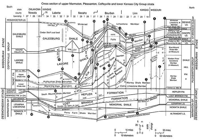
Figure 2--Correlation cross section of uppermost Desmoinesian and lower Missourian strata (upper Marmaton Group, Pleasanton Group, lower Kansas City Group-Bronson Subgroup, Coffeyville Group) from northeastern Oklahoma through southeastern Kansas to north-central Missouri, showing correction of two long-standing major miscorrelations (X-covered dashed lines), which has mandated large-scale revision of nomenclature and classification of lower Missourian strata (fig. 1). Datum is base of Exline Limestone Member. Upper case names are formations or groups, which are separated by thick lines; upper and lower case names are members or beds, which are separated by thin lines within formations. Parallel vertical lines represent limestones, dots represent sandstone, thick black vertical lines represent black phosphatic shale members or black phosphatic parts of thick members, cl represents coal bed, * represents type area of named unit. Numbers preceded by + on vertical lines represent footage omitted from diagram because of space considerations. Correlations of Exline Limestone, Hushpuckney Shale and basal Mound City dark shale across region have been confirmed by distinctive conodont faunas at many localities. Locations and references for measured sections indicated by black circled numbers are given in Appendix. [An Acrobat PDF version of this figure is available.]
Hepler Formation (revised and reclassified)
The Hepler Formation is raised in rank from member status and revised in Kansas to include all strata from the top of the Lost Branch Formation to the base of the Exline Limestone Member of the overlying Shale Hill Formation. The Hepler Formation comprises mostly unfossiliferous sandy shales, sandstones, and mudstones with an informal coal bed ("Hepler"), and includes the sparsely fossiliferous South Mound Shale Member and locally the thin lower and upper beds of the Checkerboard Limestone Member in southern Kansas. The name Hepler was originally applied to a sandstone by Jewett (1940) based on a type section near center of sec. 14, T. 27 S., R. 22 E. in southern Bourbon County north of the town of Hepler. Work by Sutton (1985), Bennison (1985), and Heckel (1991) showed that sandstone that had been called Hepler is present in three different stratigraphic intervals in Bourbon County, Kansas. The original type Hepler Sandstone of Jewett (1940) overlies the Memorial Shale above the Idenbro Limestone Member of the Lenapah Limestone (Jewett, 1945, p. 103). However, it is not known what unit overlies this sandstone, so it is uncertain whether it lies within the Memorial Shale or is incised downward from a higher unit. Because only sandstone above the more recently named Lost Branch Formation above the Memorial Shale has been recognized as Hepler elsewhere by the Kansas Geological Surveyor the Missouri Geological Survey, it is deemed appropriate to designate a new principal reference section for the Hepler nearby in a known stratigraphic position. Also, because this stratigraphic problem arose partly through the dubious practice of formally naming lenticular sandstones with the implicit assumption that they are laterally continuous, the name Hepler is expanded to include all the strata associated with the sandstones in the higher interval.
Accordingly, a new reference exposure for the Hepler Formation at its currently recognized stratigraphic position in all the rest of Kansas and in Missouri is designated at a section-line road crossing along Kansas Route 39 at SE corner sec. 4 and NW corner sec. 10, T. 27 S., R. 22 E. (fig. 3), approximately 2 mi (3.2 km) northwest of the original type Hepler Sandstone exposure. Because the dominant, shalier parts of the unit are generally poorly exposed, the boundaries of the Hepler Formation are defined in the Prong Creek Core, taken 1 mi (1.6 km) to the west (Heckel, 1991, p. 41- 43), which serves as the neostratotype (fig. 4). The upper boundary is the contact between the topmost Hepler gray shale and mudstone and the overlying Exline Limestone Member of the Shale Hill Formation. The lower boundary is typically the contact between basal Hepler sandstone or sandy shale and fossiliferous shale of the underlying Lost Branch Formation, or between basal Hepler mudstone and argillaceous limestone at the top of the Lost Branch Formation.
The Hepler Formation is nearly 60 ft (18 m) thick in its type region, where it is mainly silty shale to shaly siltstone and micaceous sandstone, mostly poorly exposed. It thins southward to 33 ft (6.6 m) at the type section of the Lost Branch Formation along Pumpkin Creek southwest of Mound Valley in central Labette County. Here it contains the thin "Hepler" coal bed above a gray mudstone at the base, overlain by dark coaly shale and thin sandstone, and ultimately by the fossiliferous South Mound Shale Member and the upper bed of the Checkerboard Limestone Member (fig. 2, sec. 31). It also thins northward to about 21 ft (6.3 m) around the K-3 roadcut, 1 mile (1.6 km) south of Uniontown (fig. 2, sec. 17), where it contains the coal above a mudstone at the base overlain by a thin sandstone, as exposed in a ravine just to the west of the roadcut. The Hepler Formation thins slightly into Linn County, where it locally contains more prominent sandstone, as exposed in the bank of the Marais des Cygnes River at Trading Post (fig. 2, sec. 9), and at various localities to the north (old quarry in SW-NE-NE sec. 25, T. 21 S., R. 24 E.) and east (road corner in NW corner of NE-NE sec. 3, T. 22 S., R. 25 E.) of Pleasanton.
South Mound Shale Member (reclassified)
The South Mound Shale Member is a distinctive marine shale unit with boundaries revised by Heckel (1991, p. 26-27), which is now reclassified as the top of the Hepler Formation in southern Kansas. It consists mainly of sparsely fossiliferous gray shale with a thin shaly skeletal limestone at the base, and a local thin sandstone or coal bed at the top. It overlies the informal "Hepler" coal bed and locally sandstone at the top of the lower part of the Hepler. It underlies argillaceous limestone to fossiliferous calcareous shale of the Exline Limestone Member of the Shale Hill Formation toward the north, and the hard, purer upper limestone bed of the Checkerboard Limestone Member of the Hepler Formation where the latter is present in extreme southern Kansas. The South Mound Shale Member was named by Jewett et al. (1965), who designated the type section just south of Mound Valley in Labette County, Kansas (center SE-SW sec. 2, T. 33 S., R. 18 E.). Better exposed reference sections have been designated by Heckel (1991, p. 44-46) in SW-NE sec. 10, T. 33 S., R. 18 E. near the Lost Branch stratotype, and along the north line of NE-NE-NW sec. 15, T. 30 S., R. 20 E. (fig. 2, sec. 26), which is the principal reference section, near the village of South Mound in southern Neosho County. The South Mound Shale Member ranges in thickness from 28 ft (8.4 m) at Mound Valley to 12 ft (3.6 m) at South Mound, thinning northward to 3 ft (0.9 m) below the argillaceous Exline Limestone Member in the streambank 3.3 mi (5.5 km) east of Kimball (SW-SE-SW sec. 27, T. 27 S., R. 21 E.; fig. 2, sec. 21) in northeastern Neosho County. It thins southward also (fig. 2), ultimately to disappearance as the two beds of the Checkerboard Limestone merge in northeastern Oklahoma.
Checkerboard Limestone Member (lowered in rank and reclassified)
The Checkerboard Limestone Member, as now recognized in extreme southern Kansas, comprises two beds. The upper bed overlies the South Mound Shale Member of the Hepler Formation and underlies the Lower Shale member of the Tacket Formation. The lower bed is equivalent to the thin shaly limestone bed in the base of the South Mound Shale Member. Named from Okmulgee County, Oklahoma, where it is classified as a formation (see Oakes, 1940), the type Checkerboard Limestone is apparently equivalent to the South Mound Shale Member because it seems to split into two beds in northern Oklahoma as seen along Wolf Creek (Heckel, 1991, p. 49) and along Little California Creek (fig. 2, sec. 35). Of these, the lower, relatively pure bed seems to grade into the lower, thin shaly limestone bed of the South Mound Shale, and the upper bed is that which was referred to as simply Checkerboard Limestone by Heckel (1991). Therefore, the Checkerboard Limestone is lowered in rank to member in Kansas, and both lower and upper beds are included with the South Mound Shale Member in the Hepler Formation. The best reference exposure for the upper bed in Kansas is along the top of the high bank of Pumpkin Creek in SW-NE sec. 10, T. 33 S., R. 18 E. above the Lost Branch type section (fig. 2, sec. 31) in Labette County, where it is about 1 ft (0.3 m) of hard, dense skeletal calcarenite. A reference exposure for the lower bed in Kansas in a place where it is classified with the South Mound Shale Member is at the principal reference section of the South Mound Shale Member in southern Neosho County. A reference exposure in a place where the lower bed is thicker (and can more readily be classified with the Checkerboard Limestone) is present in the west bank of the creek southeast of Tackett Mound just north of the road in SW-SE-SW-SE sec. 7, T. 32 S., R 19 E., in Labette County (see fig. 13). Northward for 0.6 mi (1 km) along this creek from this locality (toward the stratotype of the Tacket Formation), thin, hard, yellowish-weathering skeletal limestone beds of Checkerboard lithology occur within the South Mound Shale, lending further support for the facies equivalence of the Checkerboard Limestone Member and South Mound Shale Member.
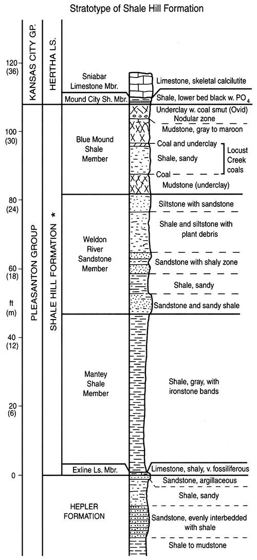
Shale Hill Formation (new name)
The Shale Hill Formation is recognized in Kansas to encompass the strata of the upper Pleasanton Group, above the Hepler Formation and below the revised Mound City Shale Member of the Hertha Limestone. The name Shale Hill was originally used by Howe (1982, but not a formal publication) for part of this succession from a complete exposure of these strata in a brick pit cut into Shale Hill at Utica, near the center of sec. 18, T. 57 N., R. 24 w., southwest of Chillicothe, Livingston County, Missouri (fig. 5). This is such an appropriate term for this shale-dominated unit in Missouri and Kansas that it is revised with correlatable boundaries for use in both states, an action tentatively accepted by Howe before his death (written communication, Aug. 26, 1992), as the name was never used further in its original more limited sense. The Shale Hill Formation consists predominantly of thick successions of gray shale (so characteristic of the Pleasanton Group), with subordinate limestone and sandstone in Kansas, where it is subdivided into four members, comprising two previously named limestone members and two newly named shale members. These are, in ascending order: Exline Limestone Member, Mantey Shale Member, Critzer Limestone Member, and Guthrie Mountain Shale Member (figs. 1, 2). The latter two members were formerly part of the Hertha Limestone, where the Critzer Limestone was the basal member, and the Guthrie Mountain Shale was the basal part of the overlying Mound City Shale Member. The lower Mound City thickens abruptly southward in southeastern Linn and north-central Bourbon counties and assumes the typical appearance of thick gray Pleasanton shale. Therefore both units are removed from the Hertha Limestone and included in the Shale Hill Formation, where they facilitate both field mapping and understanding of the depositional history of the upper part of the Pleasanton Group.
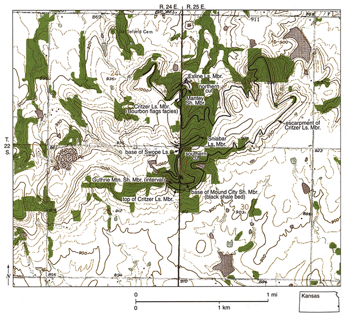
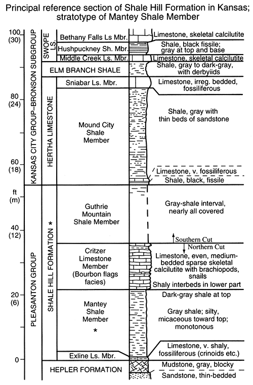
The upper boundary of the Shale Hill Formation is the contact between upper Shale Hill (Guthrie Mountain) gray shale or mudstone and the base of the widespread black shale bed (locally with thin limestone lenses) at the base of the revised Mound City Shale Member of the Hertha Limestone. The lower boundary of the Shale Hill Formation is the contact between the base of the Exline Limestone Member and gray mudstone at the top of the Hepler Formation. The Shale Hill Formation is 108 ft (32.4 m) thick at its stratotype (fig. 6; fig. 2, sec. I), and it thins gradually southward through west-central Missouri and eastern Kansas nearly to disappearance in southern Neosho and Labette County, where its position is in the base of the Lower Shale member of the Tacket Formation (fig. 2). The principal reference section of the Shale Hill Formation in Kansas is the set of roadcuts along US-69 (fig. 7), 4 to 5 mi (7-8 km) south of Pleasanton in Linn County, where it is 54 ft (16.2 m) thick (fig. 8; fig. 2, sec. 11). Here the Critzer Limestone Member (Bourbon flags facies) is well exposed, and the Mantey Shale Member (stratotype) is less well exposed beneath a recent cover of vegetation. The Exline Limestone Member has been dug out in the northern roadcut (W line NW-NW-SW sec. 19, T. 22 S., R. 25 E.), and the interval of the Guthrie Mountain Shale Member is measurable in the southern roadcut (E line NE-SE-NE sec. 25, T. 22 S., R. 24 E.).
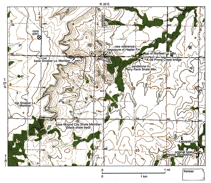
Figure 3--Map of parts of 1973 Porterville and 1973 Hepler, Kansas, 7 1/2-minute quadrangles, showing location of new reference exposure of Hepler Formation and location of Prong Creek Core (KPC) within which boundaries of Hepler Formation are defined and illustrated. Also shown are locations of older sandstone within Perry Farm Shale Member of Lenapah Limestone in bank of Prong Creek south of the K-39 bridge, and of original type section of Hepler Sandstone of Jewett (1940) to southeast, with which correlation is uncertain. Once thought to correlate with sandstone in Perry Farm Shale Member (Heckel, 1991, p. 43), the type exposure was described by Jewett (1945, p. 103) as lying above the Idenbro Limestone Member. which has been more recently confirmed by A. P. Bennison based on field work in E half sec. 22, T. 27 S., R. 22 E., 1 mi (1.6 km) to southwest.
Exline Limestone Member (newly recognized in Kansas)
The Exline Limestone Member is now recognized in Kansas. It overlies the Hepler Formation (including the north end of the South Mound Shale Member to the south), and it underlies the Mantey Shale Member. Long recognized in Missouri, the Exline Limestone was named by Cline (1941) from a stream bed exposure south of Exline in Appanoose County, Iowa, just north of the Missouri border. The Exline ranges from argillaceous fossiliferous limestone to calcareous crinoid-rich shale in Kansas, rarely more than 1 ft (0.3 m) thick and generally poorly exposed. The principal reference section for the Exline Limestone Member in Kansas is in a road ditch east of Turkey Creek (fig. 9), 3 mi (5 km) northeast of Uniontown in Bourbon County (north side, in center NW NW-NW sec. 12, T. 25 S., R. 22 E.), where it is 1 ft (0.3 m) of thin bedded argillaceous skeletal calcilutite (fig. 10; fig. 2, sec. 14). The Exline Member is well exposed as 0.5 ft (15 cm) of similar limestone, with sharp upper and lower contacts with adjacent shales, in the streambank 3.3 mi east of Kimball (SW-SE-SW sec. 27, T. 27 S., R. 21 E.; fig. 2, sec. 21) in northeastern Neosho County. It has been exposed more recently as a thin layer of shalier crinoid-rich limestone to calcareous shale with more diffuse contacts, 15 ft (4.5 m) below the limestone (Critzer) that is just downstream from the culvert beneath K-3 at the roadcut 1 mi (1.6 km) south of Uniontown (SE-NE-NW sec. 34, T. 25 S., R. 22 E.; fig. 2, sec. 17: see also Heckel et al., 1999, p. 32, Stop B1). In northern Oklahoma, the Exline Member changes facies into a bed of black shale above the upper bed of the Checkerboard Limestone (Heckel et al., 1999, p. 44, Stop B8; Heckel et al., 2002).
Figure 4--Measured section of Hepler Formation neostratotype and associated units in Prong Creek Core (taken near SE corner of NE SE sec. 5, T. 27 S., R. 22 E., and reposited at Kansas Geological Survey), showing relations with new reference exposure of Hepler Formation 1 mile (1.6 km) to east at SE corner of sec. 4 (fig. 3), and with lower sandstone in Perry Farm Shale Member of Lenapah Limestone 0.6 mi (1 km) farther east (just east of center of N line of sec. 10). It is not certain which sandstone horizon correlates with original type section of Hepler Sandstone of Jewett (1940), 2 mi (3 km) farther southeastward (center of sec. 14, all in same township). Vertical positioning of sections is based on modem elevations corrected for estimated regional westward dip of 20 ft per mi (~4 m/km). [An Acrobat PDF version of this figure is available.]
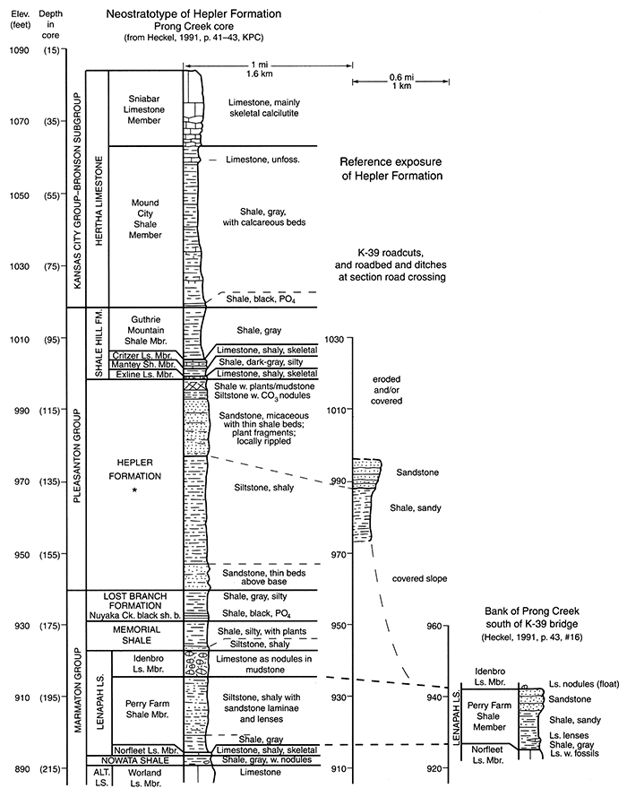
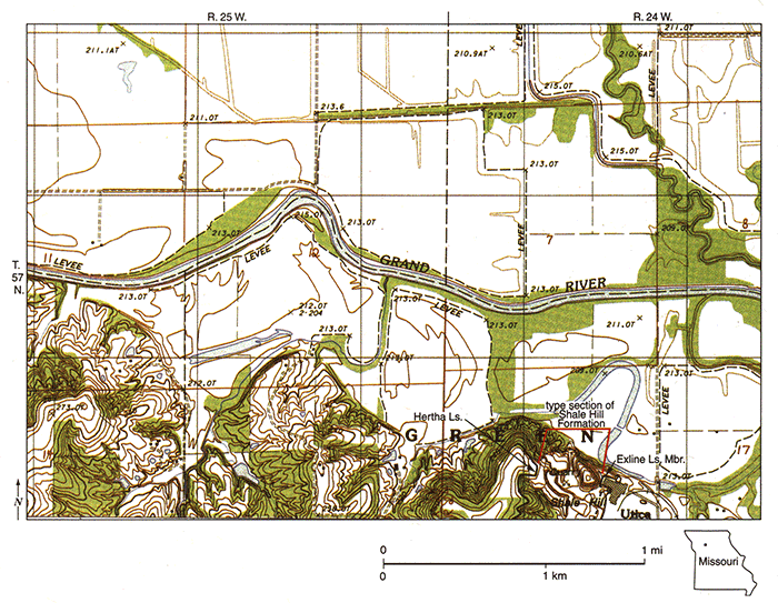
Figure 5--Map of part of 1984 provisional edition of Sampsel, Missouri, 7 1/2-minute quadrangle, showing location of type section of Shale Hill Formation in Glen-Gery Brick (formerly Midland Brick and Tile) Company quarry on northwest side of Utica, southwest of Chillicothe in Livingston County. Exline Limestone Member forms floor of pit and is exposed at top of cut behind main building to east. Hertha Limestone is exposed and accessible in slope above west face.
Mantey Shale Member (new name)
The Mantey Shale Member is newly defined in Kansas to encompass the strata above the Exline Limestone Member and below the Critzer Limestone Member. It is named from the crossroads settlement of Mantey in southeastern Linn County, where the upper part is exposed below the Bourbon flags facies of the Critzer Limestone Member 3 mi (5 km) north of town in two roadcuts, one along K-7 (east line of SE-SE sec. 30, T. 22 S., R. 24 E.), and the other along a gravel road (center of west line of NW sec. 33, T. 22 S., R. 24 E). The stratotype is selected 6.7 mi (10.8 km) northeast of Mantey at the principal reference section of the Shale Hill Formation in Kansas in the northern roadcut along US-69 (west line of NW-NW-SW sec. 19, T. 22 S., R 25 E.) where the position of the Exline Limestone Member is known (fig. 7). The Mantey Shale Member is 22 ft (6.6 m) thick at its type section (fig. 8; fig. 2, sec. 11), where it consists mainly of gray micaceous shale, becoming siltier toward the top, with a very thin bed of darker gray shale at the top in contact with the Bourbon flags facies of the Critzer Limestone Member. The lower contact is abrupt to transitional depending on how shaly the underlying Exline Limestone Member is in a particular place. The Mantey Shale Member thins southward through central Bourbon County (fig. 2) to disappearance as the thinned Critzer and Exline Limestone Members appear to converge in Neosho County. It thickens northward to at least 100 ft (30 m) in northern Linn County, where it constitutes most of the Pleasanton Group. The Mantey Shale Member contains sandstone of various thickness locally in the upper part, which is well exposed and 2 ft (0.6 m) thick at the second reference section north of Mantey, and well exposed and 14 ft (4.2 m) thick along a road leading down a hill west of the north end of Pleasanton (near north line NW-NW sec. 34, T. 21 S., R. 24 E.; fig. 2, sec. 10). Here the upper contact with the overlying Critzer Limestone Member is abrupt above a thin gray shale capping the sandstone. Northeastward in Missouri, the Missouri Geological Survey now recognizes several new members above the Mantey Shale Member (R. 1. Gentile and T. L. Thompson, in preparation); these include the Weldon River Sandstone Member overlain by the Blue Mound Shale Member (figs. 2, 6), and locally in the Kansas City area, the Knobtown Member, a fossiliferous sandstone to sandy limestone (fig. 2). The name Mantey replaces the name "Unity Farm" introduced by Howe (1982, an informal publication) for shale above the Exline Limestone Member and used for this unit in several informal working documents. This replacement is made because 1) the name Unity Farm, derived from a farm at Unity, Jackson County, Missouri, does not appear on any official topographic or county highway map, and 2) the type section designated by Howe (1982) in an abandoned and now water-filled brick pit has become increasingly slumped and covered to the point that only the top is still accessible.
Figure 6--Measured section of Shale Hill Formation stratotype in shale pit of Glen-Gery Brick Company (formerly Midland Brick and Tile), cut into Shale Hill (fig. 5) at Utica, at and east of center of sec. 18, T. 57 N., R. 24 W., Livingston County, Missouri; modified at top and base from Stratigraphic Section 25 of Howe (1982) with classification of units slightly modified. Missouri Geological Survey now recognizes members in sandstone-dominated upper part (Gentile and Thompson, in preparation), which are absent or not yet definitely recognized in Kansas.
Critzer Limestone Member (reclassified)
The Critzer Limestone Member overlies the Mantey Shale Member and underlies the Guthrie Mountain Shale Member (fig. 1, 2). It was named by Jewett (1932) from a type locality in sec. 17, T. 22 S., R. 23 E., just south of the former town of Critzer, 5 mi (8 km) west of Mound City in Linn County. It was previously classified as the lower member of the Hertha Limestone (Moore, 1949), but is now included as a member of the Shale Hill Formation in the Pleasanton Group because the southward-thickening Guthrie Mountain Shale Member, which is more characteristic of typical Pleasanton (Shale Hill) lithology, is now recognized as occurring between it and the main traceable part of the Hertha Limestone. Typical Critzer limestone facies is largely brown-weathering, typically massive, fine skeletal calcarenite, which is well exposed in reference sections at the hill west of the north end of Pleasanton (near center N line NW sec. 34, T. 21 S., R. 24 E.; fig. 2, sec. 10), and a roadcut northwest of Xenia (south line SW-SE-SE sec. 20, T. 23 S., R. 22 E.) in northwesternmost Bourbon County. Thicknesses in east-central Kansas range from 9 ft (2.7 m) in Bourbon and central Linn counties, thinning to commonly 1 or 2 ft (0.3 or 0.6 m) of shaly nodular limestone to the north.
The Bourbon flags are now recognized as a southeastern facies of the Critzer Limestone Member in east-central Kansas. This correlation resulted from careful bed tracing through the elongate area of abrupt southeastward thinning of the underlying Mantey Shale Member and corresponding thickening of the overlying Guthrie Mountain Shale Member (fig. 2) along a line extending from southeastern Linn into northwestern Bourbon County. The Bourbon flags consist of alternating 0.3-1-ft (0.1-0.3-m)-thick beds of very sparsely fossiliferous flaggy calcilutites and gray silty shales of equal or lesser thickness. The flags seem to be a slope facies (above thinning Mantey Shale Member: see Underwood, 1984) of the Critzer Limestone Member, which is more typically developed upon thick Mantey shale facies north of the flags. Maximum thickness of the Bourbon flags is approximately 35 ft (10.6 m). Good reference sections are along the northern US-69 roadcut 4 mi (7 km) south of Pleasanton (west line NW-NW-SW sec. 19, T. 22 S., R. 25 E.), the principal reference section for the Shale Hill Formation in Kansas and the stratotype of the Mantey Shale Member (fig. 8; fig. 2, sec. 11) in Linn County; the spillway to Hidden Valley Lake 4 mi (7 km) west of Mapleton (SE-SW-SE sec. 23, T. 23 S., R. 22 E.) and nearby roadcuts (where the unit is thick), and below the type Guthrie Mountain Shale Member (fig. 12; fig. 2, sec. 13) south of Mapleton (where the unit is thin) in Bourbon County.
Figure 7--Map of part of 1958 (photorevised 1978) Prescott, Kansas. 7 1/2-minute quadrangle, showing location of principal reference section of Shale Hill Formation in Kansas, and stratotype of Mantey Shale Member in roadcuts along US-69, 4 to 5 mi (6.5-8 km) south of Pleasanton. Lower three members (including Mantey Shale Member stratotype) are exposed in northern cut (east side), although Exline Limestone Member must now be dug out because of recent vegetative cover of much of shale slope; upper member (Guthrie Mountain Shale Member) interval is measured in southern cut (west side).
Guthrie Mountain Shale Member (new name)
The Guthrie Mountain Shale Member is newly defined in Kansas to encompass the strata lying above the Critzer Limestone Member and below the black shale bed at the base of the revised Mound City Shale Member of the Hertha Limestone (figs. 1, 2). It is a stratigraphically distinct gray shale unit that previously had been included as the lower part of the Mound City Shale Member where it is thin in central Linn County, but which had been commonly identified as the upper part of the Pleasanton Group where it is thick in southeastern Linn County and most of Bourbon County. Because it closely resembles the older, typically "Pleasanton" Mantey Shale Member of the Shale Hill Formation, it is removed from the Mound City Shale Member and the Hertha Limestone and reclassified (along with the intervening Critzer Limestone Member) with the Mantey Shale Member and thin Exline Limestone Member in the Shale Hill Formation of the Pleasanton Group. The name is derived from Guthrie Mountain, south of Mapleton in Bourbon County, where the upper part of the unit is exposed around the base of the hill. The type section is designated 1.5 miles (2.5 km) southwest of Guthrie Mountain (fig. 11) in a good complete exposure along the road running west from the center of NW sec. 8, T. 24 S., R. 23 E., where it is 60 ft (18 m) of gray, monotonous, silty, micaceous shale (fig. 12). The upper boundary is the contact between gray shale and the basal black phosphatic shale bed (with local limestone lenses) of the revised Mound City Shale Member, or its dark-gray equivalent where both units are thin. The lower boundary is the abrupt contact of gray shale above Critzer Limestone Member (including the Bourbon flags). The Guthrie Mountain Shale Member thins southward from its type section to only 1 or 2 ft (0.3-0.6 m) in the base of the Lower Shale member of the Tacket Formation in southern Kansas (fig. 2). It thins northward to 2 to 4 ft (0.6-1.2 m) of gray shale to mudstone, which becomes an underclay capped by the Ovid coal in Missouri. A reference section north of the type area is in the second roadcut along US-69 north of LaCygne Junction (NW-NW-SE sec. 31, T. 19 S., R 25 E.; fig. 2, sec. 8) in Linn County, where a complete section of the thin shelf facies of the gray Guthrie Mountain Shale Member, 3 ft (0.9 m) thick, is exposed beneath the black facies of the Mound City Shale Member.
Figure 8--Measured section of principal reference section of Shale Hill Formation in Kansas, and stratotype of Mantey Shale Member, composited in roadcut 4 to 5 mi (6.5-8 km) south of Pleasanton, along east side of US-69 on W line of NW-NW-SW sec. 19, T. 22 S., R. 25 E. (fig. 7) for lower three members, and in road cut along west side of US-69 (E line NE-SE-NE sec. 25, T. 22 S., R. 24 E.) for interval of upper (Guthrie Mountain Shale) member.
Prev Page--Introduction || Next Page--Stratigraphy, Coffeyville
Kansas Geological Survey, Geology
Placed on web Oct. 20, 2014; originally published 2002.
Comments to webadmin@kgs.ku.edu
The URL for this page is http://www.kgs.ku.edu/Publications/Bulletins/246/03_pleas.html