![]()
Prev Page--Stratigraphy, Lansing || Next Page--Appendix
Stratigraphy, continued
Douglas Group (redefined)
The Douglas Group overlies the Lansing Group and underlies the Shawnee Group. It is now recognized to comprise three formations in Kansas, in ascending order, Stranger Formation, Cass Limestone (newly extended into Kansas from Nebraska), and Lawrence Formation (figs. 1, 33).
Stranger Formation (redefined)
The Stranger Formation overlies the South Bend Limestone (Gretna Shale Member) and underlies the newly recognized Cass Limestone (Haskell Limestone Member) across eastern Kansas (figs. 1,33). The Stranger Formation consists mainly of shale to sandy shale with a large number of lenticular sandstone bodies, and it contains somewhat discontinuous thin limestone units and coal beds. The entire Stranger ranges from about 100 ft (30 m) thick in northeastern Kansas to at least 200 ft (60 m) thick southward. Previously subdivided completely into five named members, the Stranger Formation is now recognized to comprise the same five formal members, but with a large amount of unsubdivided strata, particularly in east-central and southeastern Kansas (fig. 33). The members are, in ascending order: Weston Shale Member, Iatan Limestone Member, both recognized only in northeastern most (Leavenworth County) and southernmost (Chautauqua County) Kansas; Tonganoxie Sandstone Member, recognized only in northeastern Kansas (Wyandotte and Leavenworth to Franklin counties) and capped by the Upper Sibley coal bed; Westphalia Limestone Member and Vinland Shale Member, both recognized across most of Kansas. Because the Tonganoxie Sandstone Member is now stratigraphically well enough delineated (Feldman et al., 1995) to be readily identified and constrained in its type area in northeastern Kansas, it excludes the multitudes of lenticular sandstones southward, some of which are now known to lie below the position of the Iatan Limestone Member. It also excludes the mudstone northward between the Iatan Limestone Member and Upper Sibley coal bed. The Stranger Formation was named by Moore (1932) and defined by Newell (1935) from exposures along Stranger Creek in southern Leavenworth County. Its principal reference section, essentially the original type section (fig. 33, section 11), extends from exposures of the South Bend Limestone (E line NE-SE-SE sec. 3, T. 12 S., R. 21 E.) up to the base of the Haskell Limestone Member (center S line sec. 3) about 2 mi (3 km) northwest of Linwood.
Weston Shale Member (revised)
The Weston Shale Member overlies the South Bend Limestone (Gretna Shale Member) and underlies the Iatan Limestone Member in northern Leavenworth and Atchison counties, Kansas, and northward (figs. 1, 33). Named by Keyes (1899) from Weston in Platte County, Missouri, its type section (fig. 33, section 9) was designated by Ball (1964) in the bluffs above Beverly, Missouri (SW-SE-NE sec. 31, T. 53 N., R. 35 W.), 4 mi (7 km) northeast of Leavenworth, Kansas. The Weston Shale Member is about 50-60 ft (15-18 m) of gray poorly fossiliferous silty shale with ironstone nodules at its type section, thinning southward and becoming poorly exposed in Kansas. It is recognized in Kansas only where the overlying Iatan Limestone Member is present, because some of the thick lower Stranger shales previously mapped as Weston in east-central Kansas where the Iatan is not yet identified could possibly be younger than the Iatan. The Weston interval is delimited beneath the lens of Iatan Limestone Member in eastern Chautauqua County, however, where it may be as much as 200 ft (60 m) of gray silty shale containing a considerable amount of sandstone that previously would have been called Tonganoxie. The thin fossiliferous Gretna Shale Member of the South Bend Limestone has been removed from the base of the Weston Shale Member (see above).
Iatan Limestone Member (now recognized in southern Kansas)
The Iatan Limestone Member overlies the Weston Shale Member and underlies the middle to upper part of the Stranger Formation in Leavenworth and Chautauqua counties in Kansas (figs. 1,33). Named by Keyes (1899) from Iatan in Platte County, Missouri, exposures. extend southeastward in the eastern bluffs of the Missouri River, where it is up to 18 ft (5.4 m) of skeletal calcilutite with phylloid algae. A reference exposure to the east along 1- 29 yielded critical conodonts (fig. 33, section 7). The Iatan Limestone Member is poorly exposed on the Kansas side of the Missouri River and is not known in the poorly exposed lower part of the Stranger Formation across most of eastern Kansas. The Iatan Limestone Member reappears around Peru in eastern Chautauqua County, where it consists of 1-2 ft (0.3-0.6 m) of shaly crinoidal limestone, exposed in the road ditch along US- 166 (NE- SE-SW sec. 23, T. 34 S., R. 12 E.) 3 mi (5 km) west of Niotaze (fig. 33, section 20, and illustrated in Heckel et al., 1999, p. 48, Stop C1). Locally it is up to 12 ft (3.6 m) of phylloid algae-dominated calcilutite, which is exposed in the old quarry 1 mi (1.6 km) northeast of Peru (SW-SE-SE sec. 10, T. 34 S., R. 12 E.). Both facies are exposed in the east bank of the creek south of old US-166, just west of Peru (near center of E line of SWSW sec. 16, T. 34 S., R. 12 E.), where the thinned algal facies overlies fossiliferous shale and crinoidal-limestone facies. This unit was mapped as Haskell Limestone Member by Ball (1964), but its conodont fauna is that of the type Iatan (Heckel, 2002) rather than that of the Haskell and overlying shale, which are now known to be exposed in higher strata along new US-166 around Peru (fig. 33, section 20; Heckel et al., 1999, p. 48, 50).
Tonganoxie Sandstone Member (restricted geographically)
The Tonganoxie Sandstone Member occurs in the middle of the Stranger Formation in northeastern Kansas above the stratigraphic position of the Iatan Limestone and below the Upper Sibley coal bed (figs. 1,33). Named by Moore (1936) from Tonganoxie in Leavenworth County, its principal reference section (fig. 33, section 10) comprises a series of exposures along US-24-40 (from S line SW-SE sec. 2, T. 11 S., R. 21 E., to center S line SE sec. 6, T. 11 S., R. 22 E.), 2 to 4 mi (3.2-6.4 km) east of Tonganoxie. The base is well exposed along K-7 (in SW-NW sec. 8, T. 11 S., R. 23 E.) above the principal reference section for the South Bend Limestone (fig. 35), 10 mi (16 km) east of Tonganoxie and 3 mi (5 km) north of Bonner Springs. The Tonganoxie Sandstone Member contains thick-bedded conglomeratic sandstone overlain by conspicuously crossbedded sandstone at the base (fig. 35) grading upward to thinner bedded and shaly sandstone. It totals perhaps up to 150 ft (45 m) in thickness in a 20-mi (33- km)-wide erosional paleovalley that was eroded through the Iatan Limestone Member, and in places through the South Bend Limestone and into the Rock Lake Shale (see Feldman et al., 1995). Although the notorious lenticularity of sandstone bodies at different horizons in thick shale-dominated formations such as the older Galesburg and Chanute caused the sandstone members in them to be reduced in rank to informal beds, the Tonganoxie Sandstone has been sufficiently well delineated by Feldman et al. (1995) to be retained as a formal member. However, it is recognized only in its type area from Wyandotte and Leavenworth, through Douglas to Franklin counties (figs. 1, 33). It contains the Ottawa coal bed at its base southwest of Ottawa in Franklin County (fig. 33, section 16). This geographic restriction of the name eliminates the problem of calling older sandstones southward "Tonganoxie" when they are known to lie below the Iatan Limestone Member, as is the case in eastern Chautauqua County.
Upper Sibley coal bed (unchanged)
The Upper Sibley coal bed overlies the Tonganoxie Sandstone Member (or the undivided main part of the Stranger Formation beyond the limits of the Tonganoxie), and underlies the Westphalia Limestone Member where it is present (figs. 1, 33). Named by Moore (1936) as the Sibley coal from Sibley (now Sibleyville) in Douglas County, it was referred to by Moore (1949) as the upper Sibley coal bed because by that time a lower coal bed was called the lower Sibley coal. The Upper Sibley coal bed is the most laterally continuous of all the coal beds in the Stranger Formation, as it extends from southern Douglas County through Leavenworth County, where it becomes 1.5 ft (0.5 m) thick east of Tonganoxie, and into Platte County, Missouri. Its principal reference section (fig. 33, section 15) is along a roadcut (east of center S line SE sec. 12, T. 14 S., R. 20 E.) 2.5 mi (4 km) east of Vinland (and 4 mi [7 km] southeast of Sibleyville) where it is 0.2 ft (6 em) thick just below the Westphalia Limestone Member.
Westphalia Limestone Member (unchanged)
The Westphalia Limestone Member overlies the Upper Sibley coal bed in northeastern Kansas and the undivided main part of the Stranger Formation southward, and it underlies the Vinland Shale Member throughout Kansas (figs. 1,33). Named by Moore (1936) from Westphalia in western Anderson County, the currently best exposure near his "typical" outcrops serves as its principal reference section (fig. 33, section 17: center Eline NE sec. 20, T. 21 S., R. 18 E.). The Westphalia Limestone Member is generally fusulinid-rich skeletal calcarenite (packstone) from its type area southward, where it attains 4 ft (1.2 m) in thickness in a good exposure below the spillway of Woodson County State Lake (fig. 33, section 18: SE-SW-NE sec. 14, T. 26 S., R. 14 E., illustrated in Heckel et al., 1999, p. 62, Stop D1). It can be traced southward to an exposure in a roadcut (center of W line SW sec. 23, T. 34 S., R. 12 E., illustrated in Heckel et al., 1999, p. 48, Stop C2) south of US-166, where it is stratigraphically between the Iatan Limestone Member and the Haskell Limestone Member (fig. 33, section 20). In Oklahoma, it is known as the Bowring Limestone (fig. 33, sections 22-23). The Westphalia Limestone Member in northeastern Kansas is up to 1.5 ft (0.5 m) of ostracode-rich calcilutite, which is well exposed above the Upper Sibley coal bed in its principal reference section 2.5 mi (4 km) east of Vinland (fig. 33, section 15).
Vinland Shale Member (unchanged)
The Vinland Shale Member overlies the Westphalia Limestone Member and underlies the Haskell Limestone Member of the Cass Limestone across eastern Kansas (figs. 1, 33). Named by Newell (1935) from Vinland in eastern Douglas County, its type section was delineated by Ball (1964) in a roadcut (E line SE-SE sec. 2, T. 14 S., R. 20 E.) 2 mi (3 km) northeast of Vinland, where it is 26 ft (8 m) of gray shale capped by sandstone (fig. 33, section 14). The Vinland Shale Member ranges from 4 to 40 ft (1.2-12 m) of sparsely to locally abundantly fossiliferous shale with lenticular sandstones. It is well exposed as nearly 5 ft (1.5 m) of fossiliferous myalinid-bearing shale overlying blocky mudstone between the Westphalia and Haskell Limestone Members below the spillway to Woodson County State Lake (fig. 33, section 18; see Heckel et al., 1999, p. 62, Stop DI).
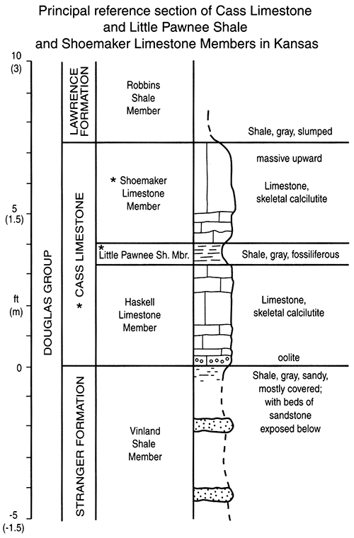
Cass Limestone (now recognized in Kansas)
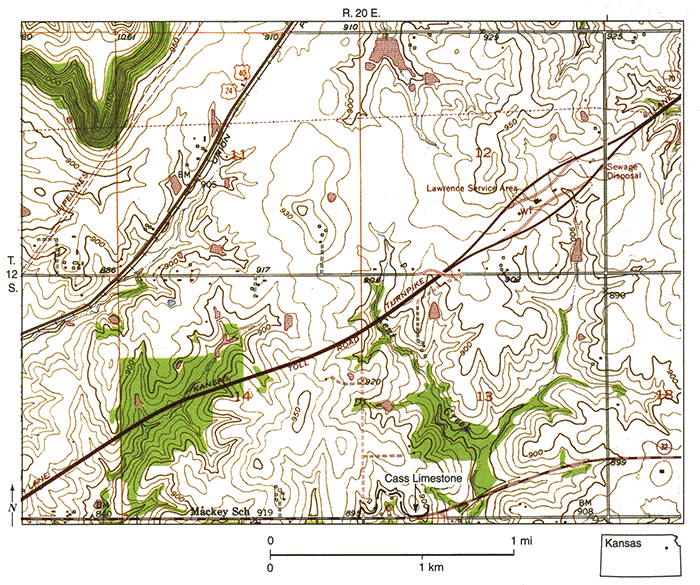
The Cass Limestone is now recognized as a formation in Kansas by transferral to it of the basal beds of the Lawrence Formation. The Cass overlies the Stranger Formation and underlies the revised Lawrence Formation (fig. 1). It comprises three members in ascending order: Haskell Limestone Member, Little Pawnee Shale Member, and Shoemaker Limestone Member (fig. 33). The Cass Limestone was named from Cass County, Nebraska, by Condra (1927), who later (1949) subdivided it into three members in ascending order: Shoemaker Limestone (as then revised), Little Pawnee Shale, and Haskell Limestone (as then erroneously correlated from Kansas). Because the thin, dark Little Pawnee Shale Member contains phosphate nodules and an abundant, distinctive conodont fauna that are found also in shale above the Haskell Limestone Member in its type region and throughout Kansas, the Haskell Limestone Member correlates with the basal rather than the upper member of the Cass Limestone in Nebraska (fig. 33). This displaces the name Shoemaker, which becomes available for the upper limestone member. The principal reference section for the Cass Limestone in Kansas is the roadcut along the north side of K-32 (center S line SW sec. 13, T. 12 S., R. 20 E.) in southwestern Leavenworth County (fig. 36), nearly 6 mi (10 km) west of Linwood, where all three members are present (figs. 37 and 33, section 12). Elsewhere in Kansas, only the Haskell Limestone and Little Pawnee Shale Members are currently known to be exposed.
Figure 36--Map of part of 1950 (photorevised 1978) Midland. Kansas, 7 1/2-minute quadrangle, showing location of principal reference section of Cass Limestone, Little Pawnee Shale Member, and Shoemaker Limestone Member in Kansas, in roadcut on K-32. east of junction with US-40-24, and west of Linwood in Leavenworth County.
Haskell Limestone Member (reclassified)
The Haskell Limestone Member is removed from the Lawrence Formation and is now classified as the basal member of the Cass Limestone in Kansas (figs. 1, 33). It overlies the Vinland Shale Member of the Stranger Formation and underlies the Little Pawnee Shale Member of the Casso Named by Moore (1932) from the Haskell Indian Institute (now Haskell Indian Nations University) in Lawrence, its type section (fig. 33, section 13) was designated by Moore (1936; see Ball, 1964) along 15th Street (center N line NE sec. 5, T. 12 S., R. 20 E.) on the east side of town. The Haskell Limestone Member generally ranges from 1 to 4 ft (0.3-1.2 m) mainly of skeletal calcilutite throughout Kansas. Oolite occurs locally at the base in its type region. Good reference sections for southeastern Kansas include the base of the spillway to Woodson County State Lake (fig. 33, section 18: SE-SW-NE sec. 14, T. 26 S., R. 14 E.; see Heckel et al., 1999, p. 62, Stop 0 J) and the new US-166 roadcuts east and west of Peru in Chautauqua County (fig. 33, section 20), where it has thinned to 0.3 ft (0.1 m).
Little Pawnee Shale Member (newly recognized in Kansas)
The Little Pawnee Shale Member is now recognized in Kansas in what had been considered the basal beds of the Robbins Shale Member of the Lawrence Formation (fig. 1). It overlies the Haskell Limestone Member everywhere in Kansas, and it underlies the Shoemaker Limestone Member of the Cass Limestone at its principal reference section on K-32 west of Linwood (figs. 37 and 33, section 12). Elsewhere, the Little Pawnee Shale Member underlies the Robbins Shale Member of the Lawrence Formation (the two latter units slightly revised by the removal from them of the Little Pawnee Shale Member and the Cass Limestone, respectively). The Little Pawnee Shale Member was named by Condra (1949) from Little Pawnee Creek in Saunders County, Nebraska, as the middle member of the Cass Limestone. Its principal reference section in Kansas is the same as that of the Cass Limestone on K-32, 6 mi (10 km) west of Linwood (fig. 36), where it is 0.6 ft (20 cm) of fossiliferous gray shale between the two limestone members (fig. 37), with sharp lower and upper contacts. Elsewhere in Kansas, the Little Pawnee Shale Member averages generally 1 ft (0.3 m) of gray to dark-gray fossiliferous phosphatic shale, locally with a thin bed of ironstone at the top. Where the overlying Shoemaker Limestone Member is absent, the upper boundary of the Little Pawnee Shale Member is more diffuse with the base of the thick, more silty, and much less fossiliferous gray Robbins Shale Member. Locally, the contact is sharper at the base of a siltstone or sandstone bed in the base of the Robbins Shale Member. Although it would be reasonably mapped with the Lawrence Formation in those places, its thinness would render it merely the line between the Cass and Lawrence formations on any map. Reference sections for the Little Pawnee Shale Member (along with the Haskell Limestone Member) include the spillway at Woodson County State Lake (fig. 33, section 18; Heckel et al., 1999, p. 62, Stop D I), and the US-166 roadcuts both east (center sec. 22, T. 34 S., R. 12 E.) and west (NE-NE sec. 20) of Peru in Chautauqua County. Along US-166, it is darker in color and greater in thickness (9-11 ft [2.7-3.3 m]) than it is elsewhere. In the eastern roadcut, it is overlain by a thin bed of sandstone (fig. 33, section 20; Heckel et al., 1999, p. 48), and in the western roadcut, it has thin lenses of shelly limestone at the top (Heckel et al., 1999, p. 50, Stop C3).
Figure 37--Measured section of principal reference section of Cass Limestone, Little Pawnee Shale Member, and Shoemaker Limestone Member in Kansas in roadcut on north side of K-32 at center of S line of SW sec. 13, T. 12 S., R. 20 E. (fig. 36), 6 mi (10 km) west of Linwood and 2.5 mi (4 km) east of junction with US-40, Leavenworth County, Kansas.
Shoemaker Limestone Member (newly recognized in Kansas)
The Shoemaker Limestone Member of the Cass Limestone overlies the Little Pawnee Shale Member and underlies the Robbins Shale Member of the Lawrence Formation (figs. 1, 33). This relationship is shown at the K-32 cut (fig. 36), 6 mi (10 km) west of Linwood in southern Leavenworth County (center S line SW sec. 13, T. 12 S., R. 20 E.), which serves as its principal reference section in Kansas (along with that of the Cass Limestone and Little Pawnee Shale Member). Here the Shoemaker Limestone Member is 3.3 ft (1 m) of skeletal calcilutite, with sharp contacts (figs. 37 and 33, section 12). The name Shoemaker (Condra, 1927) was originally applied to the entire Cass Limestone in Nebraska, but was later restricted to the lower limestone member there (Condra, 1949), when the upper limestone member was miscorrelated with the Haskell Limestone Member of Kansas. Recognizing both this miscorrelation and the result that the upper limestone member no longer had a name, R. R. Burchett of the Nebraska Geological Survey agreed that the displaced name Shoemaker can be applied to the upper limestone member there, a procedure that is accepted in Kansas. The Shoemaker Limestone Member is absent across most of eastern Kansas, but its position correlates with that of the Labadie Limestone of northern Oklahoma, which overlies the Little Pawnee Shale Member in central Osage County (fig. 33, sections 23-25).
Acknowledgments
We wish to thank the following persons who provided many types of aid during the several years that this manuscript has been in preparation: A. P. Bennison, independent consulting geologist, formerly of Tulsa, Oklahoma, discovered several critical outcrops in northern Oklahoma and southern Kansas, and provided much helpful discussion of many of the ideas concerning stratigraphic classification and nomenclature. Many graduate students, mostly from the University of Iowa, provided much of the stratigraphic information on specific units in their theses and dissertations, some of which are cited at appropriate places in the text; these students received various types of financial and other aid from the State Geological Surveys of Kansas, Oklahoma, and Missouri, and from the donors to the Petroleum Research Fund (administered by the American Chemical Society). Members of the informal Midcontinent Pennsylvanian Stratigraphic Working Group (organized under the auspices of the Midcontinent Section of the SEPM, and active in organizing annual field trips from the mid 1980's through early 1990's), provided much fruitful discussion of these topics. Specific members included: W. B. Howe (deceased) and T. L. Thompson of the Missouri Geological Survey; J. R. Chaplin and L. A. Hemish of the Oklahoma Geological Survey, who also oversaw drilling of critical Oklahoma cores; R. K. Pabian and R. R. Burchett of the Nebraska Geological Survey; J. A. French, formerly of the Kansas Geological Survey, who also oversaw drilling of critical Kansas cores; D. R. Boardman of Oklahoma State University and J. E Barrick of Texas Tech University, who provided much aid in identifying critical conodonts for correlation of several of the units. Reviewers of the penultimate manuscript include J. R. Chaplin (OGS), D. R. Boardman (OSU), T. L. Thompson (MGS), and R. R. West of Kansas State University, who provided many suggestions for improvement of the presentation of the information contained herein. J. A. French and J. P. Pope provided much appreciated field assistance in locating and sampling critical exposures. Funding for field and laboratory work was provided by the Allan and DeLeo Bennison Stratigraphic Research Fund and the John W. Swade Memorial Fund of the Department of Geoscience, University of Iowa. Marla Adkins-Heljeson of the Kansas Geological Survey shepherded the manuscript through the involved editorial process. S. L. Benoist (former University of Iowa graduate student) drafted the original of fig. 1, Pat Acker of the Kansas Geological Survey drafted a revised version of fig. 1 as well as fig. 2, and Jennifer Sims of the Kansas Geological Survey drafted all the rest of the figures and all revisions and prepared the cover art.
Prev Page--Stratigraphy, Lansing || Next Page--Appendix
Kansas Geological Survey, Geology
Placed on web Oct. 20, 2014; originally published 2002.
Comments to webadmin@kgs.ku.edu
The URL for this page is http://www.kgs.ku.edu/Publications/Bulletins/246/07_doug.html