Kansas Geological Survey, Bulletin 233, p. 253-262
by
D. L. Baars and W. Lynn Watney
Kansas Geological Survey
The basement structural fabric of the Paradox basin affected sedimentary facies throughout Phanerozoic time. Continental-scale basement wrench-fault zones were rejuvenated repeatedly throughout the Paleozoic. The Paradox pull-apart evaporite basin was formed along the northwest-southeast-trending Paradox-Wichita lineament in Middle Pennsylvanian time, facilitated by basement faults of the northeast-southwest-trending Colorado lineament. Structurally controlled shoaling conditions, formed by reactivation of basement faults, fostered marine sandstone reservoirs in Late Devonian time, crinoidal buildups in the Early Mississippian, and phylloid-algae mounds in Middle Pennsylvanian time. Apparently similar basement wrench-fault zones are present in Kansas. The midcontinent rift system is a north-northeast-south-southwest-trending fault zone that was reactivated during the Paleozoic. Northwest-southeast-trending faults along the Central Kansas-Bourbon arch complex appear to have offset structures of the midcontinent rift. Both trends are interpreted to be continental-scale conjugate wrench-fault zones with sinistral displacement along the midcontinent rift and dextral displacement along the Central Kansas-Bourbon arch complex. Stratigraphic relationships suggest repeated reactivation before Pennsylvanian uplift and erosion along the major structures. In both regions major structural lineaments are associated with smaller-scale fault patterns. Reactivation of these structures through time created paleotectonic trapping conditions at several stratigraphic intervals. Evidence is accumulating in Kansas that tectonically controlled paleotopography and paleobathymetry are major predictable factors in reservoir localization. Recognition of reactivated basement structural fabrics can provide* significant constraints on reservoir characterization and modeling.
An Acrobat PDF file containing the complete paper is available (800 kB).
Many stratigraphers base regional studies on the premise that sea-level fluctuations and their accompanying changes in tectonics and eustasy are the dominant influences on sedimentation, especially in Pennsylvanian and Lower Permian rocks. Recent studies by Vail (1987) and others emphasize the role of relative changes of sea level on sedimentation and the development of global unconformities. Sloss (1988, p. 1,665) insisted that "students and practitioners of sequence stratigraphy are, for better or worse, recorders and interpreters of tectonic evolution." There is no question that eustatic changes in sea level have significantly controlled sedimentation of late Paleozoic rocks, as with Pleistocene deposits, but tectonic controls cannot be ignored in facies modeling.
What are the effects of structural deformation on sedimentation, and what is the extent of the tectonic activity to be expected? The answers depend on the geographic proximity to structurally controlled basins and uplifts and the local heterogeneities of the basement on which the sediments were deposited. Basins of deposition and upland sources of clastic sediments depend on structural control. Carbonate sediments deposited on the shelves are hypersensitive to local water depth variations and to temperature, oxygen content, etc., which in turn depend on the configuration of the seafloor. We must not only recognize the regional effects of structure, such as the locations of basins and uplifts, but also consider the effects of local variations of structurally controlled paleobathymetry when generating facies models. In addition, we must consider that the effects of tectonic activity are often cumulative and repetitive through geologic time. Nonuniform tectonic activity will invoke a complex history in the sedimentary record. Basement heterogeneity provides the template for specific sites where deformation is episodic and focused.
Reactivations of major basement structures have controlled the development of significant salt deposits in the Paradox basin in the southern Rocky Mountains region, and prolific petroleum production has been localized in paleotectonically controlled carbonate reservoirs on the basin shelves. Eustatic sea-level changes were significant, but paleotectonic controls localized reservoir development (Baars and Stevenson, 1982). The accommodation space for marine sedimentation is provided by a combination of sea-level fluctuation and structural deformation. Many stratigraphic and structural similarities that behoove a comparative examination exist in the midcontinent.
Figure 1--Generalized location of the continental-scale structural lineaments in the western United States and location of the Paradox basin. [Modified after Baars and Stevenson (1982).]
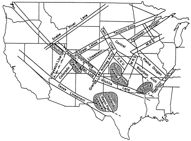
Figure 2--Major structural lineaments and their relationships to depositional features of the Paradox basin (Utah and Colorado). Note the association of the major Pennsylvanian oil fields (Aneth and Bug-Papoose Canyon fields) with major structures. [From Baars and Stevenson (1982).]
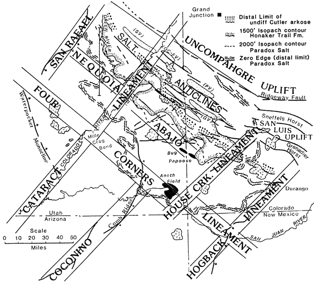
Structurally controlled shoaling conditions in the Paradox basin, formed by reactivation of the basement structural fabric, were conducive to sites of localized shallow-water sedimentation. Strong northwesterly trends of reservoir facies invariably overlie present-day structurally high blocks. Thus reactivated high fault blocks fostered marine offshore bars in Late Devonian time, and these became effective sandstone petroleum reservoirs (Baars, 1966). Further rejuvenation of the basement blocks led to production of local crinoidal buildups in Early Mississippian carbonate rocks, forming excellent petroleum traps (Baars, 1966). Later growth along basement faults formed subtle paleobathymetric shoals in Middle Pennsylvanian time. The shoals hosted phylloid-algae mounds along the southwestern shelf of the Paradox salt basin (fig. 2); prolific oil producers, such as the Aneth and Bug fields, resulted (fig. 2) (Baars and Stevenson, 1982).
The well-documented examples of structural influence on reservoir facies in the Paradox basin may serve as a working model for other regions where reactivation of basement structure is likely.
Basement structural lineaments of the southern midcontinent, for example, the southern Oklahoma aulacogen formed along the Paradox-Wichita lineament, have many similarities to those described in the southern Rocky Mountains. Earliest rifting and mafic igneous intrusions along this segment are dated at 550-525 Ma (Gilbert and McConnell, 1989). The Late Cambrian-Ordovician incipient Anadarko, Ardmore, and Marietta basins developed along the southern Oklahoma aulacogen, where up to 10,000 ft (3,000 m) of Cambrian-Ordovician sediments accumulated (Johnson, 1989). This deep structural trough lies in an analogous tectonic setting to the Paradox basin (fig. 1). The timing of the Oklahoma events coincides approximately with documented reactivation of the lineament in southwestern Colorado during Late Cambrian (Ignacio Quartzite) sedimentation (Baars, 1966) and the emplacement of northwest-trending tholeiitic diabase dikes along the adjacent Uncompahgre uplift (500 Ma) (Larson et al., 1985). Major Pennsylvanian reactivations along the lineament were only slightly older in the Oklahoma basins than in the Paradox basin (Johnson, 1989), resulting in similar tectonic histories. The northern shelf of the Anadarko basin, like the southwestern shelf of the Paradox basin, was paleotectonically controlled; both underwent significant subsidence during the Pennsylvanian and the Permian. In both cases the reactivated basement structure localized reservoir facies and unconformity relationships on the structurally high basin margins.
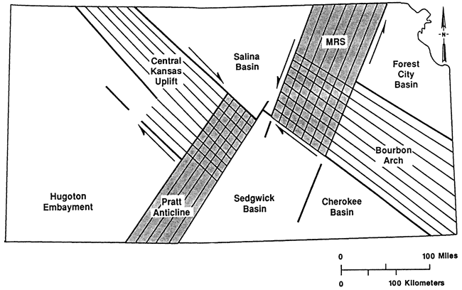
Paleozoic strata were deposited in Kansas on broad platforms, ramps, shallow basins, and localized uplifts. The location of these structural features varied throughout the Paleozoic, but consistent patterns of repeated localized uplift and subsidence are noted. From the midcontinent rift system in the Precambrian to the north Kansas basin and Oklahoma basin in the early Paleozoic and the Anadarko, Arkoma, Salina, Forest City, and Sedgwick basins in the late Paleozoic, a clear pattern of deformation geometries emerges. Structures apparently similar to basement wrench-fault zones of the Paradox basin underlie the Paleozoic section (fig. 3). The midcontinent rift system and intimately related Humboldt fault zone, dated at 1.1 Ga, constitute a north-northeast- south-southwest-trending fault swarm, the general location of which corresponds to the rifted zone, was reactivated several times during the Paleozoic. Northwest-southeast-trending faults along the Central Kansas-Bourbon arch complex appear to have offset structures of the midcontinent rift (fig. 4), although elements of the rift continue southward into the Sedgwick basin and the structural zone appears to broaden by splaying. Both trends are interpreted to be continental-scale conjugate wrench-fault zones with sinistral displacement along the midcontinent rift (Berendsen and Blair, 1986) and dextral displacement along the Central Kansas-Bourbon arch complex (Baars, 1990) (fig. 4). Faulting observed on the Kansas COCORP (deep reflection seismic) line and northeast-southwest-trending lineaments observed on gravity and magnetic maps across the midcontinent rift system coincide with faults and anticlines observed in the much younger Paleozoic strata. Also, trends of kimberlite deposits in Kansas follow basement discontinuities (Watney, 1983; Berendsen and Blair, 1986; Newell et al., 1987; Berendsen et al., 1988).
Figure 3--Inferred structures affecting the Precambrian basement in Kansas. The north-northeast-south-southwest fault complex in east-central Kansas is the midcontinent-Humboldt rift zone. Northwest-southeast faults are along the Central Kansas-Bourbon arch fault complex. These fault systems have all the characteristics of intersecting conjugate wrench-fault zones of late Precambrian age. Regional contours are from Cole (1976).
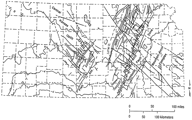
Figure 4--Interpreted structural relationships along major uplifts in Kansas.
Stratigraphic relationships suggest a long history of reactivation. The structurally controlled Precambrian hills on the Central Kansas uplift (Walters, 1946, 1958) were first buried by the Cambrian-Ordovician Arbuckle Group, which was locally removed by pre-Simpson erosion on structurally elevated fault blocks. The Middle Ordovician Simpson Group oversteps the Arbuckle and rests directly on Precambrian basement at several localities along the northern midcontinent rift and Nemaha complex and locally on the Central Kansas uplift (Walters, 1958). Local uplift and interstratal truncation suggest rejuvenation of structural blocks during the Late Ordovician, before the better known Pennsylvanian uplift and erosion of the major structural features (Dolton and Finn, 1989).
As in the Paradox basin, major structural lineaments in Kansas are associated with smaller-scale rhomboidal fracture patterns, drag-related en echelon folds, and complex, mutually offsetting fault patterns, especially in areas of intersecting basement structures. Reactivation of these structural features throughout time created unconformity-bounded trapping conditions at several stratigraphic intervals.
A typical example of episodic structural reactivation was documented in western Russell County, central Kansas, by Walters (1978, p. 60):
The . . . Gorham Oilfield is localized by a broad gentle anticline overlying a faulted Precambrian basement high. There is a displacement of 300 feet in the Precambrian granite. Faulting accounts for 50 feet of relief on the sub-Pennsylvanian unconformity surface. . . . At the level of the oil producing Lansing-Kansas City limestone . . . faulting is also evident to the extent of 50 feet of the total relief of 100 feet. The Hutchinson Salt has a thickness of less than 250 feet overlying the structurally highest area, as compared with over 300 feet in the surrounding synclinal areas. The Permian Stone Corral Anhydrite at the top of the Sumner Group . . . shows 30 feet of steep dip overlying the fault zone. Careful surface mapping of the outcropping Cretaceous Fence Post Limestone in the early 1920s disclosed 30 feet of closure, leading to the discovery of the oilfield in 1926.
In numerous examples, structurally controlled paleobathymetry localized phylloid-algae banks and lime-sand accumulations in Pennsylvanian carbonate rocks. For example, Cahoj field, located on the upper shelf of the Anadarko basin, shows structural control on facies development. Other fields in the adjoining area of Hitchcock County, Nebraska, also exhibit structural control (Watney, 1980; Dubois, 1985).
The Lansing and Kansas City groups are composed of a series of carbonate-dominated cycles deposited over extensive areas of a broad shelf in Kansas. Detailed mapping of the thickness and facies of the components of these cycles indicates clear correlations with contemporaneous local shelf topography related in many instances to sites of basement uplift. Multiple episodes of uplift can be attributed to these structures, including structural deformation during the cyclical events and during both earlier and later periods. For example, in Cahoj field Pennsylvanian strata rest directly on the Cambrian-Ordovician Arbuckle Group, whereas in the surrounding area the Pennsylvanian overlies Mississippian limestones. Thicker shoal-water carbonate deposits and porosity development occur both on and flanking Cahoj field (figs. 5 and 6). Nonmarine shales, which overlie the carbonate reservoirs and cap each cycle, thin up to 80% over these fields (fig. 7). These shales are assumed to have been passively deposited and are thicker in topographic lows. Local thinning of this shale provides a means to detect topographically positive sites.
Figure 5--Structure contour map, top of J zone carbonate in the Upper Pennsylvanian Kansas City Group, Rawlins County, Kansas. Productive areas of J zone carbonate are shown. Cahoj field lies where the Pennsylvanian locally lies unconformably on the Cambrian-Ordovician Arbuckle Group [from Watney (1980)].
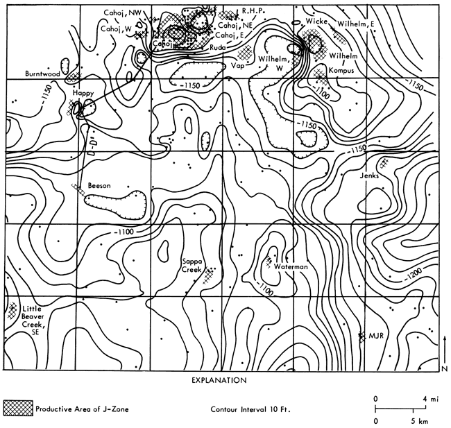
Figure 6--Carbonate facies map of upper regressive H zone carbonate in Rawlins County, Kansas. Cuttings and core control points are labeled. Facies include thick phylloid-algae mudbank and a grainstone shoal separated by areas of skeletal-lime mudstone to wackestone. Divisions shown within packstone facies separate areas in which the types of skeletal particles are different. Grainstone shoals in the north overlie Cahoj structure (compare with fig. 7). Carbonate mudbank in the south-central area is situated on a structural high, whereas mudbanks are located in modern structural lows [from Watney (1980)].
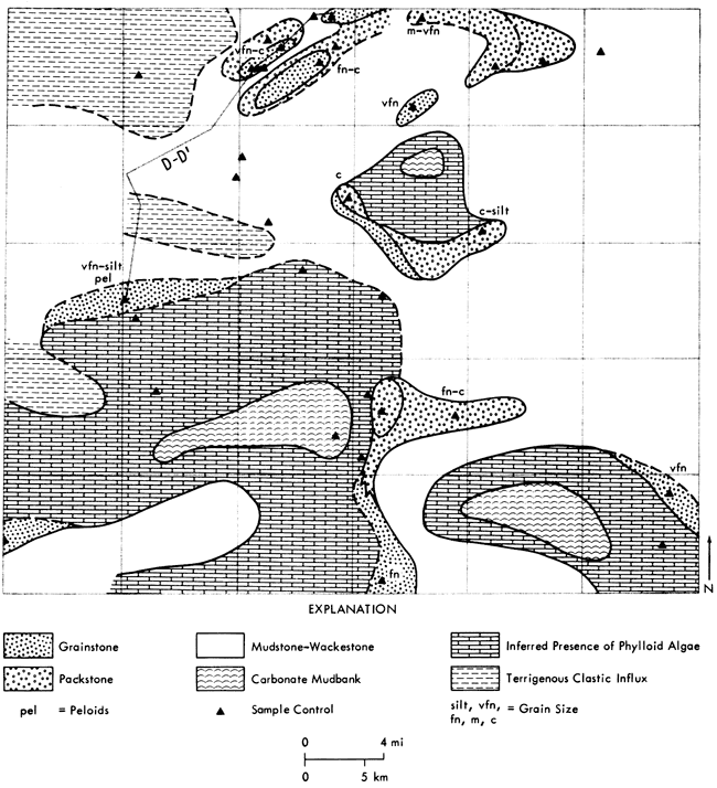
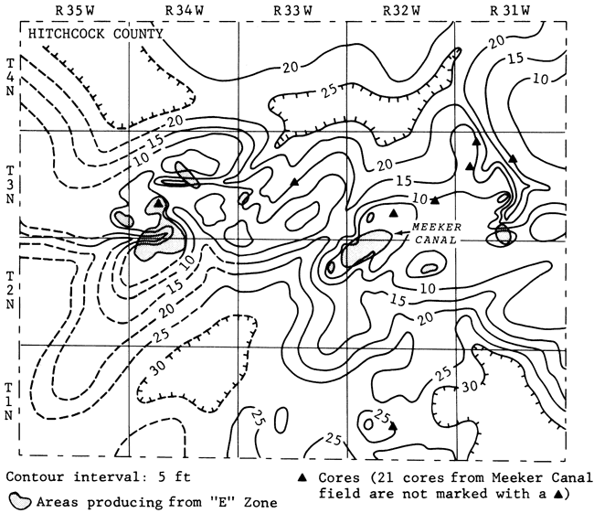
Figure 7--Thickness of nonmarine sediments of J zone in Hitchcock County, Nebraska. There is notable thinning of shale over producing areas [from Dubois (1985)].
Early subaerial diagenesis and weathering and erosion occurring at the close of each of the cycles in the Lansing and Kansas City groups are also closely linked to local paleotopography. Dubois (1985) notes deeper and more extensive solution cavity development (microkarst) on the flanks of the structures, probably reflecting a greater amount of available undersaturated ground water in these lower areas. The highs are affected by more subtle dissolution events.
In contrast to the upper shelf, the lower shelf setting around the Anadarko basin in southwestern Kansas was a broad ramp developed during most cycles. Extensive tracts of oolitic grainstones accumulated on this ramp. Local structures, such as those at Victory field (Watney and French, 1988) and Collier Flats field (Watney, 1985), are associated with unusually thick oolitic grainstones (figs. 8 and 9). In addition, other cycles in Victory field have grainstone deposits that flank the more positive areas of the field. Positive areas may or may not be sites for grainstone sedimentation, depending on the duration of sea-level stands during shallowing conditions across the ramp. Episodic structural movement, including that which occurred during deposition, and eustatic sea-level changes resulted in marked control on reservoir development.
Figure 8--Structure contour map on top of K zone. Well symbols denote production status in the zone. Shading indicates areas with elevations above -1610 ft (-491 m) [from Watney and French (1988)].
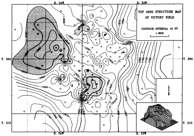
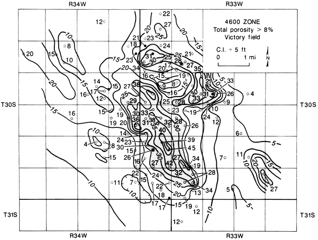
Figure 9--Thickness of porous carbonate with >8% porosity in the K zone. Shading indicates areas with thickness above 29 ft (8.8 m). Cores indicate that the porous limestone correlates with oolitic grainstone, much of which is oomoldic. Compare this map to the structure map of the K zone in fig. 10 of Watney and French (1988). The thickness from the top of the Cherokee Group to the base of the 4,600-ft (1,400-m) zone thins across Victory field, suggesting structural growth.
In general, western Kansas sedimentation was significantly modified by progressive, regional structural deformation that extended through the course of accumulation of the Kansas City Group (Watney, 1985). This affected both the type and location of depositional facies and the nature of diagenetic overprinting. The deformational pattern is linked to basement heterogeneity and tectonism.
A study in progress at the Kansas Geological Survey has revealed a high basement fault block in east-central Montgomery County in southeastern Kansas. According to subsurface data, an apparently northwest-trending fault running approximately through the town of Independence has a vertical displacement of more than 1,000 ft (300 m) at the top of the Precambrian basement. Northeasterly conjugate faults form an orthogonal high block. Potential-field mapping confirms the presence and orientation of the structure and indicates that a wedge of basaltic basement rock occurs on the down side within a regional granite-rhyolite terrane. Cambrian-Ordovician Arbuckle beds thin from 863 ft (263 m) on the down side to 416 ft (127 m) on the high side of the fault. Surface and near-surface studies by Evan Franseen and Howard Feldman (personal communication, 1990) indicate the presence of a thickened deltaic wedge in the Cherryvale Shale coincident with the southwestern comer of the basement fault block and a locally thickened oolite facies of the Drum Limestone Member parallel to and coincident with the master fault. This is clearly a case of facies localization in Pennsylvanian strata controlled directly or indirectly by recurrent basement structure.
On a larger scale in southeastern Kansas prominent episodes of outbuilding of a carbonate platform extended through two cycles in the Kansas City Group [approximately 20 mi (30 km) of southward migration during each period]. These two intervals of progradation are succeeded by another cycle that reflects notable backstepping of the shelf margin of at least 35 mi (56 km) (Watney et al., 1989). Tectonism in the Arkoma basin (foreland basin) to the south may have been responsible for the backstepping on the shelf. An abrupt rise in eustatic sea level may also have been the cause of shelf retreat. Blocky, linear shelf margins suggest that basement heterogeneity may have been important in defining the character of the shelf margin. The combined effects of tectonic subsidence, sea-level changes, and sedimentation of these deposits through computer simulation have been addressed by French and Watney (1990) and Watney et al. (this volume).
The assessment of controls on sedimentation requires an understanding of the evolving local and regional shelf configuration (subsidence and uplift) coupled with sea-level history. It is impossible to interpret how accommodation for sedimentation evolved unless both are considered in a quantitative manner (rates of change, duration, and magnitude).
Myriad possibilities exist in Kansas for localized paleotectonic traps associated with these structures. Detailed facies analyses, such as that published on the Viola Limestone by Bornemann et al. (1982), will undoubtedly disclose numerous examples of localized reservoir facies in other Paleozoic stratigraphic intervals.
Evidence is accumulating in Kansas that tectonically controlled paleotopography and paleobathymetry are major prediction factors in reservoir localization. Recognition of reactivated regmatic basement structural fabrics is important to facies and reservoir analysis and can provide significant constraints on reservoir characterization and modeling.
This report would not have materialized without the prolonged encouragement of Evan Franseen and the extra efforts of Renate Hensiek in drafting the illustrations. The manuscript was vastly improved by suggestions made by Bailey Rascoe, Bill J. Bunker, and Brian Witske; we appreciate their help and encouragement.
Baars, D. L., 1966, Pre-Pennsylvanian paleotectonics--key to basin evolution and petroleum occurrences in Paradox basin: American Association of Petroleum Geologists, Bulletin, v. 50, p. 2,082-2,111
Baars, D. L., 1976, The Colorado Plateau aulacogen--key to continental-scale basement rifting; in, Proceedings of 2nd International Conference on Basement Tectonics, D. W. Podwysocki and J. L. Earle, eds.: Denver, p. 157-164
Baars, D. L., 1990, Conjugate basement rift zones in Kansas, midcontinent, USA: Abstracts with Program, 9th International Conference on Basement Tectonics, Geological Society of Australia, p. 24
Baars, D. L., and Stevenson, G. M., 1982, Subtle stratigraphic traps in Paleozoic rocks of Paradox basin; in, Deliberate Search for the Subtle Trap, M. Halbouty, ed.: American Association of Petroleum Geologists, Memoir 32, p. 131-158
Berendsen, P., and Blair, K. P., 1986, Subsurface structural maps over the central North American rift system (CNARS), central Kansas, with discussion: Kansas Geological Survey, Subsurface Geology Series 8, 16 p. [available online]
Berendsen, P., Borcherding, R. M., Doveton, J., Gerhard, L., Newell, R. D., Steeples, D., and Watney, W. L., 1988, Texaco Poersch #1, Washington County, Kansas--preliminary geologic report of the Phanerozoic rocks: Kansas Geological Survey, Open-File Report 88-12, 116 p. [available online]
Bornemann, E., Doveton, J. H., and St. Clair, P. N., 1982, Lithofacies analysis of the Viola Limestone in south-central Kansas: Kansas Geological Survey, Petrophysical Series 3, 44 p. [available online]
Cole, V. B., 1976, Configuration of the top of the Precambrian rocks in Kansas: Kansas Geological Survey, Map M-7, scale 1:500,000
Dolton, G. L., and Finn, T. M., 1989, Petroleum geology of the Nemaha uplift, central midcontinent: U.S. Geological Survey, Open-File Report 88-450-D, 39 p. [available online]
Dubois, M. K., 1985, Application of cores in development of an exploration strategy for the Lansing-Kansas City "E" Zone, Hitchcock County, Nebraska; in, Core Studies in Kansas--Sedimentology and Diagenesis of Economically Important Rock Strata in Kansas, W. L. Watney, A. W. Walton, and J. A. Doveton, eds.: Kansas Geological Survey, Subsurface Geology Series 6, p. 120-132 [available online]
French, J. A., and Watney, W. L., 1990, Computer modeling of midcontinent cyclothems and its application in the prediction of hydrocarbon reservoirs (abs.): American Association of Petroleum Geologists, Bulletin, v. 74, p. 657
Gilbert, M. C., and McConnell, D. A., 1989, Cambrian basement rocks and the setting for deposition of Late Cambrian sediments in western Oklahoma (abs.): Late Cambrian-Ordovician Geology of the Southern Midcontinent Symposium, Norman, Oklahoma, p. 12
Hoppin, R. A., and Pan, K. K. L., 1981, Review and synthesis of tectonic lineaments of the world: A preliminary report; in, Proceedings of the Third International Conference on Basement Tectonics, D. W. O'Leary and J. A. Earle, eds.: Denver, p. 11-28
Johnson, K. S., 1989, Geologic evolution of the Anadarko basin: Oklahoma Geological Survey, Circular 90, p. 3-12
Larson, E. E., Patterson, P. E., Curtiss, G., Drake, R., and Mutschler, F. E., 1985, Petrologic, paleomagnetic, and structural evidence of a Paleozoic rift system in Oklahoma, New Mexico, Colorado, and Utah: Geological Society of America, Bulletin, v. 96, p. 1,364-1,372
Newell, K. D., Watney, W. L., Cheng, S. W. L., and Brownrigg, R. L., 1987, Stratigraphic and spatial analysis of oil and gas production in Kansas: Kansas Geological Survey, Subsurface Geology Series 9, 86 p. [available online]
Salop, L. J., 1983, Geological evolution of the earth during the Precambrian: Springer-Verlag, New York, 459 p.
Sloss, L. L., 1988, Forty years of sequence stratigraphy: Geological Society of America, Bulletin, v. 100, p. 1,661-1,665
Stevenson, G. M., and Baars, D. L., 1986, The Paradox, a pull-apart basin of Pennsylvanian age; in, Paleotectonics and Sedimentation in the Rocky Mountain Region, United States, J. A. Peterson, ed.: American Association of Petroleum Geologists, Memoir 41, p. 513-540
Vail, P. R., 1987, Part 1, Seismic stratigraphy interpretation procedure--key definitions of sequence stratigraphy; in, Atlas of Seismic Stratigraphy, A. W. Bally, ed.: American Association of Petroleum Geologists, Studies in Geology 27, v. 1, p. 1-10
Walters, R. F., 1946, Buried Precambrian hills in northeastern Barton County, central Kansas: American Association of Petroleum Geologists, Bulletin, v. 30, p. 660-710
Walters, R. F., 1958, Differential entrapment of oil and gas in Arbuckle Dolomite in central Kansas: American Association of Petroleum Geologists, Bulletin, v. 42, p. 2,133-2,173
Walters, R. F., 1978, Land subsidence in central Kansas related to salt dissolution: Kansas Geological Survey, Bulletin 214, 82 p. [available online]
Warner, L. A., 1978, The Colorado lineament--a middle Precambrian wrench fault system: Geological Society of America, Bulletin, v. 89, p. 161-171
Watney, W. L., 1980, Cyclic sedimentation of the Lansing and Kansas City Groups (Missourian) in northwestern Kansas and southwestern Nebraska--a guide for petroleum exploration: Kansas Geological Survey, Bulletin 220, 72 p. [available online]
Watney, W. L., 1983, Relationship of epeirogeny and sedimentation: Kansas Geological Survey, Open-File Report 83-28, 16 p.
Watney, W. L., 1985, Swope Limestone (K zone) in central and southwestern Kansas-the role of core in understanding reservoir development and mechanisms responsible for cyclic sedimentation; in, Core Studies in Kansas-Sedimentology and Diagenesis of Economically Important Rock Strata in Kansas, W. L. Watney, A. W. Walton, and J. A. Doveton, eds.: Kansas Geological Survey, Subsurface Geology Series 6, p. 102-119
Watney, W. L., and French, J., 1988, Characterization of carbonate reservoirs in the Lansing-Kansas City groups (Upper Pennsylvanian) in Victory Field, Haskell County, Kansas; in, Occurrence and Petrophysical Properties of Carbonate Reservoirs in the Rocky Mountain Region, S. M. Goolsby and M. W. Longman, eds.: 1988 Carbonate Symposium, Rocky Mountain Association of Geologists, p. 27-46
Watney, W. L., French, J. A., and Franseen, E. K., eds., 1989, Sequence stratigraphic interpretations and modeling of cyclothems: Kansas Geological Society Guidebook, 41st Annual Field Conference, 211 p.
Wise, D. U., 1963, An outrageous hypothesis for the tectonic pattern of the North America Cordillera: Geological Society of America, Bulletin, v. 74, p. 357-362
Kansas Geological Survey
Comments to webadmin@kgs.ku.edu
Web version April 7, 2010. Original publication date 1991.
URL=http://www.kgs.ku.edu/Publications/Bulletins/233/Baars/index.html