![]()
Prev Page--Petrology || Next Page--Paleoecology
Depositional Environment
Regional Setting and Stratigraphic Framework of Smoky Hill Deposition
The Smoky Hill Member of Kansas was deposited in the eastern part of a broad seaway, which in Late Cretaceous time extended from the Gulf of Mexico to Arctic Canada. The subsiding trough containing these waters has been called the Rocky Mountain Geosyncline by many authors (e.g., Gilluly, 1963, p. 146; Armstrong, 1968, p. 432; Gill and Cobban, 1973, p. 1) although in recent years the name "Western Interior basin" (e.g., Kauffman, 1969, p. 227; Kauffman and others, 1977, p. 6) has come into regular use. In tectonic terms the trough is a retroarc foreland basin (Dickinson, 1976, p. 1278). Throughout the U.S. Western Interior region, subsidence was greatest near the western edge of this structural depression. Locally, as in southwestern Wyoming and central Utah, Upper Cretaceous deposits alone reach thicknesses between 5490 and 6100 m (18,000-20,000 ft) (Reeside, 1944). In general, Cretaceous deposits are coarser grained toward the western margin of the basin (Reeside, 1957, p. 508) where, in complexly intertongued relationships, fine-grained offshore marine shales give way to nearshore and marginal marine sandstones and these, in turn, pass westwardly into nonmarine deposits of coastal swamps, fluviatile systems, and piedmont areas (see Pike, 1947; Spieker, 1949; Weimer, 1970, p. 273; McGookey and others, 1972, maps). Along the western margin of the basin, distribution of lithofacies delineates clearly a major western source for trough-filling terrigenous detritus. This detritus was derived from tectonic highlands, the Sevier orogenic belt of Armstrong (1968, p. 435), which were raised within the area embraced formerly by the Cordilleran geosyncline (Gilluly, 1963, p. 146; Armstrong, 1968, p. 432; King, 1977, p. 95). As a part of the stable craton, the area lying east of the seaway was low and flat (Reeside, 1957, p. 509) and during most of Late Cretaceous time was not an important source for terrigenous detritus that entered the basin (Weimer, 1970, p. 273; McGookey and others, 1972, p. 195; Tourtelot and Cobban, 1968, p. 7).
Across most of the Western Interior basin, late Cretaceous strata manifest marked cyclicity; nowhere is this cyclicity marked more clearly than along the western side of the former seaway, where dark-colored shales and light-colored sandstones are intertongued complexly. Pike (1947, p. 15) has reviewed two major hypotheses that have been advanced to account for such intertonguing, namely (1) repeated vertical oscillation within the seaway during deposition, and (2) alternation of transgression caused by downward movements of the crust and regression resulting from subsequent infilling of the basin margin by terrigenous detritus. The latter hypothesis was favored by Sears and others (1941), Pike (1947), and Weimer (1960). Such a simple explanation of this cyclicity is probably rendered untenable by present-day understanding of Cretaceous global sea-events. For example, Mörner (1980) has noted the influence of tectonoeustacy or geoidal eustacy in causing major Cretaceous transgressions and regressions.
Details of cyclic deposition in the Four Corners area and in central Utah have been elaborated in classic papers by Pike (1947) and Spieker (1949), respectively, and Weimer (1960) has documented on a regional basis four major Late Cretaceous depositional cycles that can be recognized through much of the Rocky Mountains and adjacent Great Plains regions. These cycles are named for peak-transgressional units, which are (ascending) Greenhorn, Niobrara, Claggett, and Bearpaw. Kauffman (1977) claims that these four cycles, and possibly two others of Late Cretaceous age, are widely correlative around the world and are the result of eustatic fluctuations of sea level related to plate-tectonic movements (= tectono-eustacy). Jeletzky (1977, 1978) has issued a major challenge to this interpretation on the basis of stratigraphic data from several western and Arctic Canadian basins in which sea-level curves show little correspondence to Kauffman's scheme or to each other. Jeletzky (1977,1978) states that the major control of such cyclic fluctuations is local, regional, or interregional tectonic movement. Perhaps Jeletzky's view is confirmed best by the work of Peterson and Kirk (1977), who recognized nine transgressive-regressive cycles in four basins situated in the southern part of the Colorado Plateau, and by Gill and Cobban (1966, p. 45), who concluded that their extensive studies of the Pierre Shale had failed to yield a clear-cut example of transgression and regression that could be "unquestionably related to anything other than local subsidence and uplift." Similarly, Gill and Cobban (1973, p. 21) report that the westwardly directed Bearpaw transgression of western Montana was synchronous with marine regression across eastern Wyoming, which demonstrates the significance of local tectonic events in determining strandline movements. For the Montana area, these authors (p. 33) believe that crustal instability, combined with varying rates of detrital influx, is the best explanation for the transgressive and regressive events. Discrepancies in number and timing of Western Interior Late Cretaceous depositional cycles emphasize the need to view with great caution any generalizations concerning their relationship to worldwide events. The stratigraphic section in each area must be interpreted on its own specific features, coupled with data deriving from studies of global sea-level events. Good recent discussions of Western Interior cyclicity have been presented by Gill and Cobban (1973), Ryer (1977), Kauffman (1977), Cooper (1977), and Hancock and Kauffman (1979).
Although global eustacy undoubtedly accompanied plate-tectonic events such as late Cretaceous widening of the North Atlantic, serious doubt has been cast on the premise that eustacy alone could account for aggregate thicknesses of marine strata of the Western Interior region (Bond, 1976; Cross and Pilger, 1978). These authors point out that subsidence must have been greater than can be attributed solely to supracrustal loading. This excess of subsidence has been attributed to low-angle subduction of a Pacific oceanic plate (Dickinson, 1976; Cross and Pilger, 1978). Aside from causative factors, it is evident that for much of the Western Interior region the dominant crustal movement was, in fact, downward. How else could we explain the widespread accumulation of marine strata to a thickness commonly much greater than 1000 m, with only minor unconformities?
Depositional cycles in the Western Interior Late Cretaceous are most evident along the western side of the basin, where transgressive events are recorded in westwardly directed tongues of offshore marine shale and regressions are marked by eastwardly directed tongues of nearshore and marginal marine sandstone. The youngest of the regressive sandstone bodies corresponds to the Fox Hills Sandstone of the classic Western Interior section, and before the advent of Tertiary erosion may have extended eastward into Kansas. Because other major western sand tongues did not approach Kansas even closely, the pattern of cyclicity there differs greatly from that in the Four Corners area, central Utah, etc. In Kansas the lower part of the Upper Cretaceous section contains a complete marine cyclothem (Hattin, 1964), and corresponds to the first transgressive-regressive cycle documented by Weimer. Uppermost strata of the Greenhorn cyclothem comprise sandy or silty beds known as the Codell Sandstone Member of the Carlile Shale, which nearly everywhere in Kansas is overlain sharply by chalky limestone belonging to the Fort Hays Limestone Member, Niobrara Chalk. Unlike the Greenhorn cyclothem, basal marine beds of which are marginal marine sandstones and sandy or silty shales, the second (Niobrara) transgressive sequence commences with offshore chalky limestone.
The Codell and Fort Hays are separated by a northeastwardly widening lacuna, and the base of the Fort Hays is demonstrably diachronous, ascending biostratigraphically in the direction of transgression (Hattin, 1975a). At the Codell-Fort Hays contact evidence of subaerial erosion or nonmarine deposition is lacking. This has prompted the conclusion (Hattin, 1975a) that during the regressive part of the Greenhorn cycle marine waters were not withdrawn from the Kansas area. Lack of terrigenous detrital units at the base of the Niobrara transgressive sequence indicates remoteness of the eastern shoreline at the time Fort Hays deposition was initiated. Assuming that the purest Niobrara carbonates represent peak transgression in the second late Cretaceous cycle, the transgressional maximum apparently occurred sometime during deposition of the Fort Hays Member (Fig. 53). Less pure carbonates of the Smoky Hill Member thus are deposits of a protracted regressional episode that was marked by occasional minor incursions (Coates and others, in press). Smoky Hill strata lack uniform carbonate content, some intervals being noticeably less chalky than others (e.g., middle part of section exposed at Locality 19).
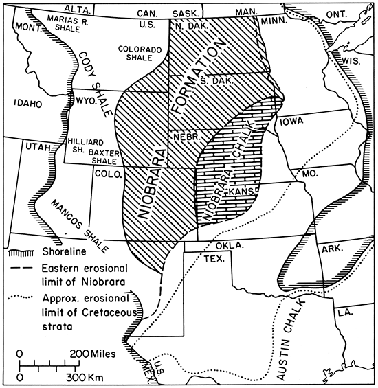
Figure 53--Map showing paleogeography at peak of Niobrara transgression, regional distribution of Niobrara Chalk (Formation), and nomenclature of laterally contiguous marine units. Position of eastern shoreline is conjectural. Compiled from numerous sources.
These differences manifest variable rates of terrigenous detrital influx against relatively uniform, dominantly carbonate production. Times of least detrital deposition are marked by bioturbated or granular chalk intervals. Near the top of the Smoky Hill, impure chalk gives way to chalky shale, then to calcareous shale, which is followed upward by noncalcareous shale of the Sharon Springs Shale Member, Pierre Shale. In the Pueblo area of Colorado, chalky and calcareous shales assigned to the basal, unnamed transition member of the Pierre (Scott and Cobban, 1964) are overlain by the Apache Creek Sandstone Member. The latter unit represents terminal deposits of the Niobrara cyclothem. Although not developed in Kansas, the Apache Creek Member is equivalent to dark noncalcareous shales belonging to the lower part of the Sharon Springs Member of Kansas (Gill and others, 1972). Overlying beds of the Sharon Springs are transgressive deposits of the Claggett cycle, the peak of which is represented by organic-rich shales belonging to the middle, buttress-forming unit of the Sharon Springs in Kansas (Gill and others, 1972, p. 8).
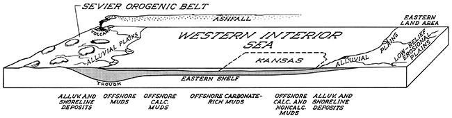
Carbonate-rich units of the Greenhorn Limestone and Niobrara Chalk are tongue-like bodies sandwiched be: tween dark-colored clayey shales of a huge clayey shale lithosome that includes such units as the Mancos Shale, Lewis Shale, Pierre Shale, Graneros Shale, Blue Hill Shale Member of the Carlile Shale, Claggett Shale, and Bearpaw Shale. Along the western side of the basin this lithosome is intertongued with the sandstone bodies mentioned above. The western side of the basin was the locus of maximum subsidence and development of greatest statigraphic thicknesses, whereas deposits along the eastern side are much thinner and evince subsidence of much smaller magnitude. The basin can be divided structurally into two broadly defined zones, namely a western, axial zone, in which tectonism was most active, and a broad, stable eastern shelf (Fig. 54). Kauffman (1977, p. 84) has suggested a fourfold division, including a broad "hinge" zone between the stable shelf of Kansas-Nebraska-Iowa and the actively subsiding parts of the basin. However, lateral changes of facies across the so-called "hinge zone" are very gradual and do not suggest an abrupt change in slope of the sort associated with tectonic hinges. For example, individual limestone beds of the Kansas Greenhorn can be traced to westernmost New Mexico, and the Niobrara changes facies gradually westward from chalk, to chalky shale, to calcareous shale and is thus recognizable as far west as the Four Corners area, north flank of the San Juan Mountains, and northwestern Colorado. Such persistence suggests that the stable shelf extended far to the west, and that the hinge zone lay for the most part west of the Southern Rocky Mountains. The model proposed by Weimer (1978, fig. 2) is a more acceptable interpretation.
Figure 54--Block diagram depicting a portion of the Western Interior basin during deposition of the Niobrara Chalk, and nature of the bordering lands.
The Niobrara Chalk of Kansas represents deposition of carbonate-dominated muds far from the major, western sources of terrigenous detritus. Detrital content of the Niobrara increases gradually westward, apparently reflecting western source areas. At the eastern (erosional) limit in Kansas the Niobrara has its highest carbonate content, suggesting that the eastern shoreline was far removed from the present outcrop, and that the eastern detrital source areas had little influence on Niobrara deposition in Kansas. Because the Niobrara is truncated erosionally along the entire eastern outcrop, position of the shoreline is conjectural. In contrast, the excellent stratigraphic record in the axial zone of the basin permits definition of the western shoreline with considerable accuracy (Fig. 53).
The names Niobrara Chalk and Smoky Hill Chalk Member are used only in Kansas, Nebraska (Condra and Reed, 1943), and southeastern South Dakota (Robert Stach, oral communication, 1980). Niobrara strata are traceable southwestward across Colorado and northern New Mexico to the San Juan basin, where they pass into shale and sandstones of the Mancos Shale (Molenaar, 1973), and where the name "Niobrara Shale Member" is used locally (e.g., Lamb, 1968). In southern Colorado (e.g., Dane and others, 1936; Scott and Cobban, 1964) and northeastern New Mexico (e.g., Griggs, 1948; Pillmore and Eicher, 1976) the formal name is Niobrara Formation. In both areas the upper member is known as Smoky Hill Marl Member (Dane and others, 1936; Griggs, 1948) or Smoky Hill Shale Member (Gill and Cobban, 1964; Pillmore and Eicher, 1976). In southern New Mexico the Niobrara equivalent is assigned to the Mesa Verde Formation (or Group) (Cobban and Reeside, 1952, chart lOb). In western Colorado the Niobrara passes into calcareous beds of the Mancos Shale (Fisher and others, 1960) and in east-central Utah is represented by the Bluegate Shale Tongue of the Mancos (McGookey and others, 1972). In a broad area embracing northern Colorado (e.g., Kent, 1967a), southern Wyoming (e.g., Frerichs and others, 1975), the Black Hills (Robinson and others, 1964; Tourtelot and Cobban, 1968), eastern Montana (Montana Geological Society, 1969, p. 9), western South Dakota (Robert Stach, oral communication, 1980), North Dakota (Gries, 1954; Carlson, 1964), and Minnesota (Shurr and Cobban, 1979), the name "Niobrara Formation" is in general use; and the upper member, where recognized formally, is the Smoky Hill Chalk Member in South Dakota (Agnew and Tychsen, 1965, p. 171; Robert Stach, oral communication, 1980) and Smoky Hill Member in northern Colorado (Trexler, 1967; Weimer, 1978). Northward in Montana the Niobrara equivalent is known as the First White Specks interval of the Colorado Group or Colorado Shale (Montana Geological Society, 1969, p. 9), and in southern Canada as the First White Specks zone of the Alberta Group (Williams and Burke, 1961), Thistle Member of the Wapiabi Formation (Stott, 1963, p. 114), or Boyne Member of the Vermillion River Formation (Wickenden, 1945, p. 3). For the Manitoba escarpment section McNeil and Caldwell (1981, p. 62) have recently abandoned the name "Boyne Member" in favor of the term "Niobrara Formation." In the central and northern Rocky Mountains the Niobrara equivalent is embraced by the Cody Shale of south-central Montana and north-central and northwestern Wyoming, and by parts of the Baxter Shale and Hilliard Shale (Cobban and Reeside, 1952, chart lOb; McGookey and others, 1972). Regional distribution of the Niobrara and its equivalents is depicted in Figure 53.
Origin of Chalk Components
The principal component of most Smoky Hill strata is calcium carbonate, nearly all low-magnesium calcite, which occurs in several forms. Examination of samples in the field and of thin sections and scanning electron micrographs (Hattin, 1971, 1975b, 1981) has permitted identification of nearly all carbonate components. Laminated and nonlaminated chalk, the most abundant lithotypes in the member, consist largely of coccoliths and coccolithophorid debris. These minute plant fossils are skeletal remains of coccolithophores, members of the Chrysophyceae (golden-brown algae), modern examples of which are planktonic forms occurring mainly in openocean waters of normal salinity. As coccoliths are shed from the living algae, or when coccolithophores die, the skeletal remains sink directly toward the sea floor, where the tiny skeletal plates may accumulate as part of the seafloor ooze.
Alternatively, coccolithophores may be eaten by pelagic organisms, such as copepods and salps, in which case the skeletal remains sink more rapidly to the sea floor in fecal pellets (Lohmann, 1902; Honjo, 1975; Bathurst, 1971, p. 267; Hattin, 1975b). Coccolithophores were exceedingly abundant in Cretaceous seas because widely distributed chalk deposits of that system are generally rich in coccoliths (e.g., Sorby, 1861; Cayeux, 1935, p. 35; Black, 1953; Hancock and Kennedy, 1967; Hattin, 1971, 1975c; Scholle, 1977). In the Smoky Hill chalks, coccoliths are concentrated in fecal pellets, which are abundant to profuse in all chalks examined by me, and occur in more scattered fashion in the chalk matrix. I conclude, therefore, that coccoliths were transported to the sea floor in pellets and as individual plates or coccospheres not associated with pellets.
Also abundant in Smoky Hill rocks are tests of calcareous foraminifers, most of which are remains of planktonic forms belonging to the families Globotruncanidae, Marginotruncanidae, Heterohelicidae, and Planomalinidae (Frerichs and Dring, 1981). Like coccoliths, the pelagic foraminifers sank upon death to the sea floor, where their tests contributed importantly to accumulation of carbonate mud. Diverse species of calcareous benthic foraminifers have been reported from the Niobrara and its equivalents (e.g., Loetterle, 1937; Kent, 1967a) but are an insignificant element in Smoky Hill thin sections examined by me.
Chalky carbonates and certain calcisiltites of the Kansas Greenhorn contain conspicuous quantities of calcispheres, which are the spheres, or oligosteginas, of European chalk literature. Few structures in Smoky Hill thin sections can be identified with certainty as calcispheres, which therefore are a negligible component in the member.
Nearly all chalky strata of the Smoky Hill contain abundant, vertically compacted ellipsoidal calcareous pellets composed of micritic carbonate. These structures are also abundant in chalky beds of the Greenhorn Limestone (Hattin, 1975b,c) and Fairport Member of the Carlile Shale (Hattin, 1962). I concluded (Hattin, 1962, p. 106; 1975b) that these are the fecal pellets of coccolithophore-eating organisms. Scanning electron micrographs of pellets show them to be composed almost entirely of coccolithic material. Pellets everywhere contain richer concentrations of coccoliths than the adjacent matrix of nonpelleted micrite.
Other carbonate constituents apparently are of benthic or diagenetic origin. Inoceramid valves, valve fragments, and isolated prisms are principal among benthic allochems of Smoky Hill chalks. Although unbroken inoceramid valves are nearly ubiquitous, fragmented material is common through the entire section. Fragmentation occurred most probably by pre burial decay of the organic binding (Tarr, 1925, p. 259), which occurs within both nacreous and prismatic layers of living bivalves (Wilbur, 1964). Presence in the Smoky Hill of teeth deriving from shell-crushing sharks such as Ptychodus suggests that these predators may have broken up the skeletons of larger benthic invertebrates; however, evidence of bite marks on inoceramid valves was not recorded during this study, and fragments of inoceramid valves were observed in only two of the many coprolites that were examined. Most fragmental remains of Smoky Hill inoceramids are disposed so as to indicate in situ disintegration rather than the ravages of predator attack. The only significant exception is the lens of biomicrite that lies between Marker Units 21 and 22 in SE Sec. 1, T. 14 S., R. 31 W., Gove County, which probably resulted from a brief, localized episode of gentle sea-floor scour.
In Smoky Hill strata, shells of ostreid bivalves probably outnumber those of inoceramids. Although some species of the latter lack epizoic oysters, large forms such as Inoceramus (Volviceramus) grandis and I. (Platyceramus) platinus are generally encrusted by scores to hundreds of Pseudoperna congesta specimens, and these oysters occur also as isolated, articulated specimens or even as single valves. Collectively, the oysters are an important carbonate component in much of the Smoky Hill section, especially in the lower half, below Marker Unit 11.
Other calcitic skeletal remains, including those of stalked cirripeds, rudists, and various poorly represented bivalve groups, are responsible for most other primary carbonate material in the Smoky Hill.
The soft, porous character of most Smoky Hill rocks attests to generally poor cementation. These rocks usually contain only small amounts of secondary overgrowths on coccoliths, inoceramids, and foraminifers, and crystals of interstitial cement. The bioturbated and granular chalk units are generally harder, more resistant to weathering, and in general contain larger amounts of secondary calcite. A logical source for this secondary calcite is originally aragonitic skeletal material, such as that derived from ammonite conchs and the nacreous layer of inoceramids. Aragonitic skeletal matter is virtually nonexistent in the Smoky Hill chalks, and potential void spaces that may have been left by its removal have invariably been closed by compaction. This suggests early diagenetic dissolution and precipitation elsewhere, probably as neomorphic overgrowths on skeletal remains and as interstitial cement. The greater degree of textural alteration in bioturbated chalk beds indicates that burrowing activity enhanced neomorphism by improving the movement of interstitial fluids.
The calcite that now fills or nearly fills most foraminiferal chambers consists of large, sparry crystals that lack evidence of centripetal growth. Even partially crushed tests commonly contain undeformed calcite crystals, which shows that crystal growth occurred after the tests were compacted. Incipient microstylolites, representing pressure solution during deeper burial diagenesis, suggest a possible source for sparry calcite now preserved in foraminiferal tests. Support for this interpretation comes from the lenses of Uintacrinus limestone, which not only contain the most numerous and best-developed microstylolites in the Smoky Hill, but are also the best-cemented rocks in the entire section!
Skeletal grains deriving from vertebrates, especially including fish scales and small bone fragments, are essentially ubiquitous in Smoky Hill chalk samples. These grains are scattered throughout the section, and except for a single lens in SE Sec. 1, T. 14 S., R. 31 W., are not concentrated as in skeletal calcarenites and calcirudites of the older Greenhorn Limestone. The Smoky Hill Member is renowned as a natural repository for well-preserved, articulated vertebrate skeletons; however, evidence of predation, especially in the form of skeletal fragments in coprolites, is common. Predation and disintegration of carcasses on the sea floor or floating in the water column, coupled with gentle current action, could account easily for occurrence of vertebrate skeletal debris throughout the Smoky Hill composite section. Except for rare, nonaquatic-dinosaur skeletons, the animals that contributed the vertebrate debris were inhabitants of the sea in which Smoky Hill deposits accumulated.
Nearly all thin sections of little-weathered Smoky Hill chalk contain wisps or flakes and angular silt-sized grains of opaque, black organic matter. This material is interpreted as plant debris, derived possibly from distant land sources and transported as small particles, or may in part represent fragments produced by disintegration of large floating or waterlogged tree trunks and limbs. Fossilized logs have been reported from the Smoky Hill (Williston, 1897, p. 243) and carbonized logs were recorded during my investigation. Total organic carbon content of chemically analyzed Smoky Hill samples ranges to as much as 5.8 percent (Table 4). This is much higher than indicated by abundance of microscopically visible grains, which indicates that much of the organic carbon was derived from the organic matter of marine organisms, i.e., from decay of foraminifers, coccolithophores, bivalves, fish, algae, etc., on the sea floor. This interpretation is supported by isotopic evidence presented recently by Arthur and others (1981). Preservation in Smoky Hill muds of so much organic matter is clear evidence for reducing conditions below the mud-water interface, and helps to account for olive gray coloration in most of the little-weathered chalk. Highly weathered samples of chalk contain no visible evidence of organic carbon, presumably because of oxidation during weathering.
All analyzed Smoky Hill chalk samples contain terrigenous detritus comprising silt and finer-grained quartz, kaolinite, and mixed-layer illite-montmorillonite. A few samples contain trace amounts of feldspar. Some of the quartz is visible in thin sections, but the other minerals, and most of the quartz, were detected by X-ray diffraction. This indicates that the bulk of terrigenous detritus is clay-sized material and is mostly disseminated throughout the rock rather than being concentrated in detritus-rich laminae. The gradual decrease in purity of Smoky Hill carbonate rocks in a westward direction from Kansas to western Colorado and northwestern New Mexico suggests progressively greater dilution of pelagic carbonate muds in that direction, presumably by detritus derived from the Sevier orogenic belt.
Insoluble residue content of nonbioturbated chalk samples from throughout the composite section averages 31.4 percent of the rock. This is far greater than can be accounted for by terrigenous detritus and organic carbon. Secondary minerals, including gypsum, alunite, iron oxide, and especially pyrite, make up much of the remaining residue material. Pyrite, which occurs mostly as minute framboids, but locally replaces skeletal calcite, formed diagenetically during decay of organic matter in a reducing environment that existed below the mud-water interface.
Physical Aspects of the Environment
General Statement.
Speculation on the depositional environment of Cretaceous chalk deposits has occupied many pages in the geological literature, but most of the work pertains to the strata in England and northwestern Europe. Quite recently, however, the American chalk formations have received increased attention, partly because the field for environmental investigation is fertile and partly because of growing interest in chalk deposits as oil and gas reservoirs. Some of the more embracive contributions to depositional environments of Western Interior chalks include works by Reeside (1957), Miller (1958, 1968), Hattin (1962, 1971, 1975c, 1981), Asquith (1970), King (1972), Frey (1972), Kauffman (1967, 1969, 1977), Eicher (1969), Frush and Eicher (1975), and Baldwin (1976). The flood of recent papers concerned with chalk genesis and inhabitation of soft substrates by marine benthic organisms, coupled with lithologic and stratigraphic information for the entire composite section, makes possible an embracive environmental synthesis of the Smoky Hill Member in Kansas. In the following sections pertinent environmental parameters are examined on the basis of inorganic and biological evidence. Paleoecology of the major macroinvertebrate groups is treated separately.
Depth of Deposition.
In Kansas Geological Survey Bulletin 209 (Hattin, 1975c), I presented an historical account of the controversy regarding depth of deposition of Cretaceous chalk deposits. From extensive reports of the Deep Sea Drilling Program we know with certainty that chalk is a common result of diagenetic processes that alter nannoplankton oozes beneath the deep-sea floor. For more than a century, debate has waxed and waned as to whether or not Cretaceous chalk deposits are an ancient analog of deep-sea oozes or the product of considerably shallower depositional settings. As noted by Hancock (1975, p. 517), "it is a subject about which a fair amount of nonsense has been written." With apologies to Jake, and with minor emendations and additions, my review is repeated here.
The abundance, or apparent abundance, of planktonic foraminifera in some chalk deposits led many early authors to conclude in favor of oceanic depths for deposition of the British and European chalks (e. g., Huxley, 1858; Fuchs, 1883; Hume, 1894). At that time only Cayeux (1897, p. 527) argued forcefully against the deep-water interpretation, stating that the maximum depth of chalk deposition in the Paris Basin was less than 150 fathoms (275 m). In their classic monograph of the British Chalk, Jukes-Browne and Hill (1903, 1904) concluded, principally on foraminiferal evidence supported by evidence from other fossil groups, that the Lower Chalk was deposited at depths of 400 to 500 fathoms (732-915 m) (1903, p. 358), the Middle Chalk at depths that usually exceeded 500 fathoms (915 m) (1903, p. 557) and probably reaching a maximum of approximately 650 fathoms (1185 m), and the Upper Chalk at depths as great as 700 fathoms (1281 m) (1904, p. 377). The evidence from foraminifera has been reviewed extensively by Earland (1939), who fairly well dispelled the notion that the Cretaceous chalk is to be compared with deep-sea deposits. He concluded (1939, p. 20) that foraminifera and other fossils of the British Chalk suggest deposition at depths to 50 fathoms (92 m) or less (for impure deposits near the base of the Chalk) to a maximum of 300 fathoms (549 m). Earland reviewed the work of Jukes-Browne and Hill (1903, 1904) and pointed out many errors in depth interpretation based upon foraminifers.
Sorby (1861, p. 197) was aware that foraminifers may be comparatively rare in chalk and that coccoliths are the chief constituent of the chalk matrix, and on the basis of coccolith abundance he implied that the Chalk is a Cretaceous analog of modern deep Atlantic muds. Quite recently, however, Hay and others (1967, p. 431) mentioned the considerable abundance of coccoliths in shallower shelf deposits. Furthermore, Scholle and Kling (1972) have reported concentrations of coccoliths that comprise as much as 20 percent of the deposits in lagoonal environments off British Honduras (= Belize) at depths no greater than 140 feet (43 m). Black (1965) notes that in modern tropical waters the maximum concentration of coccolithophorids is commonly at about 50 m (164 ft) whereas around the British Isles the maximum concentration is at depths of only 10 to 20 m (33-66 ft).
In a summary of chalk genesis, Tarr (1925, p. 253) cited conclusions of workers who favored the idea of great depositional depth but noted that much of the chalk may have been deposited in water depths less than 20 fathoms (37 m). In the past few decades, opinion has shifted in favor of shallower water origin for the European chalk. Boswell (1933, p. 201) wrote, "Conclusions as to the evidence of fossils would have been stated more boldly in favor of shallow depths but for considerations of the early globigerina ooze analogy." More recent study of planktonic foraminiferal percentages (Barr, 1961) suggests that the British Chalk need not have been deposited at depths much greater than 90 m (295 ft). By use of discriminant functions to maximize differences in foraminiferal assemblages, and by comparing Chalk Marl foraminifers with comparable living forms, Burnaby (1961) concluded that depth fluctuations occurred, with definite deep- and shallow-water phases. For the latter he estimated depths as little as 5 fathoms (9 m). For a higher part of the British section, and on the basis of comparison with modern sponge bathymetry, Reid (1962) concluded that the Late Turonian Chalk Rock was deposited in water not less than 50 fathoms (92 m) deep and not necessarily more than 110 fathoms (201 m). For the Chalk as a whole he (Reid, 1968, p. 558) stated that the hexactinellid sponge evidence indicated depths of at least 100 m (328 ft) but not necessarily more than 200 to 300 m (656-984 ft). Continental geologists have also been revising to smaller figures the maximum depositional depth of the Late Cretaceous European chalks. Nestler (1965, p. 113) concluded that the benthos of the German Rugen Chalk could have lived at depths ranging from 100 to 250 m (328-820 ft). This is in marked contrast to estimates of Voigt (1929) who, on the basis of bryozoan abundance, concluded that the Rugen Chalk was deposited at depths ranging from 300 to 1000 m (984-3280 ft) or more. Steinech (1965, p. 195) believed that this formation was deposited at depths not greater than 300 m (984 ft), on the grounds of comparison with modern depth ranges of some brachiopod genera found in the Rugen Chalk.
Hudson (1967) concluded that the softness of the English Chalk is related to initial absence of aragonite in chalk-forming muds. He interpreted this as the result of aragonite solution in a bathymetric range where particulate calcite is not dissolved. He stated that this would occur between depths of 150 m and 280 m (492-918 ft).
European and British chalk deposits contain numerous hardgrounds--nodular beds of chalk formed by lithification at or just beneath the sea floor. Kennedy and Garrison (1975) have summarized the main factors regarding hardground development. Many authors have stated that hardgrounds represent subaerial exposure of carbonate muds, whereas others have concluded that hardgrounds represent submarine lithification during periods of shallowing and depositional stillstand when the sea floor had become sufficiently shallow to be affected by wave and current action. The occurrence of numerous, closely spaced incipient to fully developed hardgrounds, as in the section at the east cliff, Dover, England, suggests that the sea floor was subjected repeatedly to shallowwater conditions. The origin of hardgrounds during episodes of shallowing is a view shared by Bromley (1967a, p. 507). For the well-known English hardground known as Chalk Rock he suggested that glauconitization occurred during shallowing to depths not less than 100 m (328 ft) and that phosphatization in this bed occurred during shallowing to depths not less than 50 m (164 ft). Kennedy and Garrison (1975, p. 321) estimated depositional depth of "clearly shallow water horizons" of the British Chalk, including the Chalk Rock hardground, to have been on the order of 50 m (164 ft) or less. Part of their evidence consisted of enterolithic algal borings, which have also been reported from the Chalk Rock by Bromley (1968, p. 250), indicating photic-zone depths. According to Scholle (1974, p. 181) most of the Chalk contains little or no evidence of algal growth, thus suggesting deposition below the photic zone, which probably extended to depths of at least 150 to 200 m (492-656 ft). The minimum depth for normal chalk deposition was thus on the order of 200 to 300 m (656-984 ft), and was probably not much in excess of the latter figure (Scholle, 1974, p. 181). On the basis of his literature review, Hancock (1975, p. 519) concluded in favor of a greater maximum depth, 600 m (1968 ft), but as noted by Scholle (1974, p. 181) depths on this order are difficult to envisage over broad continental platforms.
The preponderance of recent opinion favors deposition of the English and European white chalk facies at depths not significantly exceeding 300 m (984 ft), with the sea in some places, or at times of hardground formation, having been less than 50 m (164 ft) deep. However, in his recent summary of the topic, Hancock (1975, p. 519) concluded that the collective evidence suggests that deposition of chalk-forming muds occurred at depths ranging from 100 to 600 m (328-1968 ft). Obviously, the depositional depth of the white chalk facies was not uniform throughout the area of deposition. Depositional depths were thus compatible with the epicontinental shelf or platform tectonic settings.
Relatively few estimates have been made for depth of deposition of Upper Cretaceous chalk units of the Western Interior and adjacent seas of North America. On the basis of ammonite morphology, Scott (1940, p. 322) suggested probable bathymetric ranges of 20 to 80 or 100 fathoms (37 to 146 or 183 m) for the Eagle Ford and Austin groups of Texas. On the basis of Austin Chalk faunal and stratigraphic data, Dravis (1979, p. 58) postulated a depositional depth of 10 m (33 ft) or less for the area embracing San Antonio and Austin, Texas. Dravis (1979, p. 59) suggested southward deepening of water in the Austin depositional environment to more than 100 m (328 ft) in the present-day Texas subsurface. In a comparison of overall faunal characteristics of the Austin Chalk and Taylor marl of Texas, Clark and Bird (1966, p. 323) stated that the depth range for deposition of carbonate-rich muds could have been from 200 ft to 6000 ft (61-1830 m) but this range was reduced to between 200 and 1600 ft (61 and 488 m) on the basis of associated lithotypes. The Annona Formation of Arkansas contains an offshore, deeper-water shelf chalk facies, which was deposited at depths between 75? m and 125? m (246-410 ft), according to Bottjer (1978, p. 211). His estimate is based on embracive stratigraphic, petrologic, and paleoecologic characters.
In the Western Interior region chalky strata are assigned to two formations, the Greenhorn and Niobrara. For the Greenhorn Limestone, Kauffman (1969) has suggested depositional depths ranging from 100 to 500 ft (31-153 m), based mainly on comparative analysis of recent and fossil faunal elements. Much greater depths were postulated by Eicher (1969), who concluded from foraminiferal evidence that the central (eastern Colorado) part of the seaway during Greenhorn deposition was 1640 ft (500 m) or more in depth. From determinations of paleoslope over which the Greenhorn transgression occurred, Eicher (1969) postulated maximum depth between 2000 and 3000 ft (610-915 m). Even by combining the effects of maximum eustatic sea-level rise (see Bond, 1976) and isostatic compensation for water load, adjusted for shallowing caused by accumulation of upper Cretaceous deposits laid down prior to the transgressional peak, the minimum depth suggested by Eicher's paleoslope model could not have been attained without substantial tectonic subsidence. Disregarding the possibility of tectonic subsidence, the maximum depth at the peak of Greenhorn deposition could have been no greater than approximately 380 m (1246 ft). However, total thickness of the predominantly marine upper Cretaceous section in western Kansas was originally in excess of 760 m (2500 ft), so tectonic subsidence must have occurred at some time in order to accommodate the observed marine sequence. The maximum depth for Greenhorn deposition thus could have been in excess of 500 m (1640 ft).
Depth estimates for Niobrara deposition also have broad range. Without stating specific evidence, Miller (1968, p. 18) estimated the depth of Smoky Hill deposition to have been shallow, probably about 40 m (131 ft), with Fort Hays deposition occurring at even shallower depth. By comparing fossil and living macroinvertebrates, Kauffman (1967) implied a depth range of 50 to 500 ft (15-152 m) for Niobrara deposition, but suggested later (Kauffman, 1969, p. 227) that central basin carbonates of the Western Interior were deposited at depths of 100 to 200 ft (30-61 m), mostly within the photic zone. In a comparison of Niobrara and modern foraminifers, Kent (1967b) concluded that the Niobrara was deposited at depths of approximately 200 m (656 ft). Mainly on the basis of Kauffman's analysis, Frey (1972, p. 48) noted a deepening trend during Fort Hays deposition and stated that the trend continued during Smoky Hill deposition. This trend was also determined by Baldwin (1976, p. 24, 27), who suggested a minimum depth for Fort Hays deposition of 20 m (66 ft), and a maximum depth of 200 m (656 ft) at the top of the member. A markedly different interpretation of Niobrara depositional depth, at least in the Wyoming area, is presented by Asquith (1970), whose study of depositional topography in the west-to-east shelf-slope-basin setting suggests that the water at times exceeded a depth of 2000 ft (609 m). Depths of this order would have required considerable contemporaneous tectonic subsidence.
In their study of eustatic rise of sea level in relation to plate tectonics, Hays and Pittman (1973, p. 20) concluded that the depths of Cretaceous epeiric seas would have been generally less than 500 m (1640 ft) and possibly only 100 to 200 m (328-656 ft). Bond (1976) gave an overestimated maximum of 310 m (1017 ft) for Late Cretaceous eustatic sea-level rise. Neither of these estimates includes possible added depth owing to isostatic adjustments during transgression or to contemporaneous subsidence. Therefore, maximum depth could have been considerably in excess of these estimates.
The Niobrara of Kansas is part of a major depositional cycle, which is widely manifest in Coniacian and Santonian marine strata of the U.S. Western Interior, and is also represented by the Austin Chalk of Texas and the First White Specks zone of western Canada. During Niobrara deposition a white chalk facies was being deposited across a broad area of northwestern Europe and the British Isles. The broad distribution of a relatively deepwater chalky facies suggests that extra-basinal control, i.e., eustacy, was a major factor leading to transgression during the Niobrara cycle (see Marner, 1980). In Kansas, initial deposits of the Niobrara are sandy basal beds of the Fort Hays Member, which lie with regional disconformity upon the Carlile Shale. The post-Carlile surface was produced (Hattin, 1975a) during an episode of nondeposition and sublevation upon which Niobrara deposition was initiated when transgressional waters deepened sufficiently to permit accumulation of permanent carbonate muds. Water depth during the stillstand can only be surmised. King (1963, p. 248) estimated that sand or gravel cannot be moved solely by waves at depths greater than 30 to 40 ft (9-12 m), but noted that the action of tidal currents extends to much greater depths on modern shelves. The evidence for tidal action in the Western Interior Cretaceous is rather extensive (Klein and Ryer, 1978), so that the minimum depth for movement of basal Fort Hays sand and local phosphate pebbles apparently exceeded the maximum depth of wave transport suggested by King (1963). According to Gross (1977, p. 122) the accumulation of silt and clay particles, which would include nannoplankton-rich carbonate muds, occurs on many modern shelves at depths of 50 to 150 m (164-492 ft). Assuming less physical rigor on the Western Interior carbonate shelf than on modern open-ocean shelves, the lower end of this range (50 m) is regarded as closer to the depth at which Niobrara muds may have begun to accumulate. This figure exceeds that for minimum depth (15 m) indicated by Kauffman (1969, p. 238) for gryphioid pycnodont oysters, which occur in lowermost Fort Hays beds, and that (20 m) indicated by Baldwin (1976) on the basis of foraminiferal data. In summary, initial deposits of the Fort Hays may have been deposited in waters no more than 50 m (164 ft) deep, and possibly as little as 15 m (49 ft) deep. Progressive deepening during Fort Hays and Smoky Hill deposition has been noted above.
Just how deep these waters became is a matter of speculation. As Smoky Hill deposition proceeded, water depth apparently became gradually greater, and bottom circulation of this water decreased, possibly because of density stratification. During final phases of deposition, as represented especially by strata at Localities 21 and 24, benthic macroinvertebrates became scarce, suggesting that depth was near the lower limit of the vital isostrate, which Byers (1979a) suggests was at 150 m (492 ft) in poorly circulated interior basins. However, flat depositional topography and the huge regional extent of the Niobrara depositional environment suggest that circulation probably affected the bottom at depths greater than 150 m. Overlying beds of the Sharon Springs Member, Pierre Shale, represent a lethal isostrate (Byers, 1979b, p. 22), indicating that the water was even deeper than during terminal Smoky Hill deposition. Inoceramids and oysters occurring in the Smoky Hill were interpreted by Kauffman as indicating depths of 200 to 500 ft (61-152 m), the larger figure according well with the lower limit suggested by Byers' work. Despite Kauffman's implication (1969) that deposition occurred mostly within the photic zone, I have not detected endolithic algae in any thin sections of Smoky Hill macroinvertebrate shells. For clear water, absence of endolithic algae indicates water depths of at least 150 to 200 m (492-656 ft) (Hancock, 1975, p. 518).
If the maximum possible (310 m) eustatic rise in sea level postulated by Bond (1976) did occur during the Niobrara transgression, and did prevail during most or all of Smoky Hill deposition, then it is possible to estimate water depth from non-biologic considerations. A 310 m sea-level rise would involve an additional 93 m (305 ft) of depth increase owing to isostatic adjustment for water load (Bloom, 1967; Eicher, 1969), bringing total depth to 403 m. This depth must be adjusted for the shallowing effect of deposition during transgression, and for subsidence under the sediment load. Thickness of the partially compacted Niobrara section was approximately 300 m, and would have depressed the crust isostatically approximately 200 m (Eicher, 1969, p. 1087). This means a possible maximum water depth on the order of 300 m.
This figure does not include an allowance for tectonic subsidence, which would have caused greater deepening, and is based also on the assumption that maximum eustatic rise in sea level prevailed during deposition of the upper Smoky Hill, which seems unlikely (see Kauffman, 1977, p. 85). Although Smoky Hill muds accumulated during a time of regional regression, lithologic and faunal evidence indicate that greatest water depth occurred near the close of Smoky Hill deposition. This suggests that in western Kansas, at least, depth was indeed influenced by tectonic subsidence, and not solely by eustacy and isostatic adjustment of the crust. Based on all of the factors discussed above, the depth of Smoky Hill deposition appears to have ranged from a minimum of 150 or 200 m (492-656 ft) to a maximum in excess of 300 m (984 ft).
Temperature.
Early in the twentieth century, knowledge of climatically controlled latitudinal variations of Cretaceous biotas was understood sufficiently to be summarized in some detail by Dacque (1915, p. 423-426). At that time paleontologists recognized in the Northern Hemisphere a warm-water Tethyan or Mediterranean belt, in which deposits are characterized by rudists, corals, actaeonellids, nerineids, and larger benthic foraminifers, and a cool-water Boreal belt, in which deposits are characterized by belemnites. Reeside (1957, p. 512) concurred that the Mediterranean realm had a warm or perhaps tropical climate but noted that the more northerly realm had a temperate, possibly cold-temperate, but not Arctic climate. Jeletzky (1971, p. 12-13) opined that the term "boreal" is misleading because fossil evidence from higher latitudes indicates at least a warm-temperate climate "everywhere in the 'Boreal' Realm." Accordingly, Kauffman (1973, p. 367) has substituted the term "north-temperate realm" and noted that this realm contains no truly Arctic faunas and has few cold-temperate bivalves.
In his review of biogeographic data on Cretaceous foraminifers, Bergquist (1971, p. 1567, 1578) postulated for North America a climatic zonation comprising tropical, warm-temperate, mild-temperate, cool-temperate, and cold zones. In this scheme the warm-temperate zone includes the area of the present Gulf Coastal Plain, the mild-temperate zone embraces the southern part of the Western Interior region (including Kansas), the cool-temperate zone includes the northern part of the U.S. Western Interior and all of western Canada, and the northern cold zone includes the Arctic portion of Alaska and Canada. An alternate zonation was proposed by Sohl (1971, p. 1611), who stated that through most of Cretaceous time North America was characterized by three main biotic provinces, including (1) a Caribbean-Central American-Baja Californian province having a warmwater fauna of Tethyan affinity, (2) a Coastal Plain-southern Western Interior province having subtropical to warm-temperate assemblages, and (3) a Californian-northern Western Interior province having a Boreal fauna. This scheme has been modified recently by Coates and others (in press), who recognize within the U.S. Western Interior three climatic belts, including Southern Interior, Central Interior, and Northern Interior provinces. Of these, the Central Interior Subprovince extended normally from Kansas, Central Colorado, and Utah northward to Montana and South Dakota. These authors (Coates and others, in press) imply that waters of these subprovinces were warm-, mild-, and cool-temperate, respectively, but that boundaries of the three subprovinces migrated both northward and southward, at times establishing marginal Tethyan influence in the Central Interior Subprovince, which included Kansas. Such fluctuations apparently account for occurrence, at some levels in the Kansas Cretaceous, of such typical Tethyan forms as Vascoceras and Desmoceras (Greenhorn Limestone), Durania and Texanites (in Kansas represented by the jaw apparatus, Spinaptychus) (Niobrara), Trachyscaphites (Pierre Shale), and keeled planktonic foraminifers. Although these, as well as other subtropical forms, are widespread at certain levels within the Central Interior Subprovince, at few places are they abundant elements of the local fauna.
Similarly, a few horizons in the Kansas Cretaceous contain sparse representation of faunal elements more usually associated with the cool water (e.g., Dunveganoceras in the Greenhorn Limestone, belemnites in the Fairport and Smoky Hill chalks), and which probably migrated southward from the Northern Interior Subprovince. Unfortunately, the horizons at which Smoky Hill belemnites occur are not known. Theoretically, such fossils should occur in beds lying between those containing rudists, but mixing of Tethyan elements and belemnites has been recorded (e.g., Campanian of Sweden; Surlyk and Christensen, 1974), which casts a certain suspicion on the validity of climatic zonation schemes that have narrow divisions. Valentine (1967) stated that latitudinal ranges of individual species are narrow at times of increased climatic zonation, but several Niobrara species have wide latitudinal distribution, suggesting that climatic zonation was not quite as narrow and well defined as implied by Coates and others (in press). Examples of Smoky Hill species that have broad latitudinal distribution include Inoceramus (Volviceramus) grandis (New Mexico to Alberta), Inoceramus stantoni (New Mexico to northwestern Montana), Scaphites depressus (southern Colorado to central Alberta), C. choteauensis (southern Colorado to southern Alberta?), Desmoscaphites bassleri (northwestern New Mexico to northwestern Montana), and Scaphites hippocrepis (central Texas to Saskatchewan). These distributions suggest rather broad climatic zonation of the Western Interior Sea during much of Smoky Hill deposition. Nevertheless, distinct south-to-north differences in Western Interior faunas have been documented (e.g., Kent, 1969; Sohl, 1971; Bergquist, 1971; Jeletzky, 1971; Coates and others, in press), and climate, i.e., temperature, is accepted generally as the principal controlling factor.
Rudists have been recorded sparingly in the Kansas Smoky Hill (see Fig. 31), aptychi of Texanites are sparse (Miller, 1968), and keeled planktonic foraminifers extend geographically well to the north of Kansas (Kent, 1969). Based on the evidence of these few forms, Tethyan influence was very small in Kansas during deposition of the Smoky Hill chalk, and as noted by Coates and others (in press) was sporadic rather than continuous. Likewise, belemnites are rare in the Smoky Hill, suggesting that Kansas lay mostly below the southern geographic limit of these forms. A warm- or mild-temperate climatic belt is thus suggested for the Kansas area during most of Smoky Hill deposition.
Only sparse foraminiferal data are available for determining temperature during Smoky Hill deposition. The keeled planktonic foraminifer Globotruncana is a tropical form, the northern geographic limit of which was the 20°C isotherm (Bandy, 1960). This genus has been recorded widely in strata of Niobrara age in the Western Interior, including an area that lies well to the north of Kansas (Kent, 1969), suggesting minimum temperatures of 20°C for the upper part of the water column during at least part of Smoky Hill deposition. Another Niobrara keeled planktonic foraminifer, Praeglobotruncana, likewise of tropical affinity, has been recorded even farther to the north than Globotruncana (Kent, 1969; Bergquist, 1971). According to Bergquist (1971, p. 1594) the occurrence of Marginotruncana marginata Reuss in the Niobrara of Kansas, Colorado, and New Mexico suggests a moderate temperature for a large area of the Western Interior Sea. From these interpretations one can also conclude that during Niobrara deposition water temperature fluctuated between mild-temperate and subtropical.
Lowenstam (1964) has summarized oxygen-isotopic data that confirm the low- to high-latitude decline of Cretaceous paleotemperatures in the Northern Hemisphere. Isotopic methods have been utilized by Scholle and Kauffman (1977) to demonstrate climatic fluctuations from warm-temperate to subtropical in the U.S. Western Interior, but their data remain unpublished.
Substrates and Bottom Conditions.
During Smoky Hill deposition carbonate muds accumulating on the sea floor were mainly soft oozes, and were perhaps even soupy. Such interpretation is suggested by modern deep-sea nannoplankton-rich muds, which have original porosity in the range 70 to 80 percent (Scholle, 1977, p. 987), and in some instances have porosity as high as 94 percent (Cook and Cook, 1972, p. 945). The argument is supported by occurrence in the Smoky Hill of abundant inoceramid bivalves having morphological characters that are adaptations to life on soft substrates (see section on paleoecology). Near absence of infaunal body fossils among Smoky Hill benthic forms is further evidence of substrates too soft to support any but specially adapted, epifaunal skeletonized organisms. Animals that attached themselves to or bored into hard substrates occur almost. exclusively on shells of inoceramids, rudists, and cephalopods. Further evidence for soft substrates is manifest in the broad, short growth form of many small rudists, evidence from distribution of rudist epizoans for toppled life attitude in some large adult forms, and changes of rudist growth direction in some specimens in response to toppling.
Bioturbated and granular chalk beds have higher carbonate content than stratified chalks, and represent relatively brief depositional intervals during which influx of terrigenous detritus was less than normal. Preservation of burrow structures in these beds apparently reflects either (1) firmer substrates, which fostered inhabitation by the trace-making organisms (worms), or (2) early inception of lithification, which prevented burrow structures from being obliterated by compaction. If the substrates were indeed firmer than those represented by the laminated chalk, then one would expect that such beds may also have supported other infaunal organisms. The only Smoky Hill bed in which I recorded infaunal bivalves (Lucina sp. A) is in fact a bioturbated unit. On the other hand, if preservation of burrow structures resulted from early lithification of these carbonate-rich beds, the implication is clear that the laminated chalks were also bioturbated but lack burrow structures because of subsequent compaction. Actually, the laminated chalks do contain sparse, scattered burrow structures, but the beds could not have undergone much bioturbation because the process would have destroyed much or all of the lamination and stratified grain fabric, as well as the very thin, widely traceable bentonite seams that occur in most well-stratified units. Therefore, the first explanation seems more plausible and the paucity of infaunal body fossils, even in bioturbated beds, is owing less to preservational factors than to poor benthic environmental conditions generally. After all, diversity of the epifaunal benthos was always very low, with inoceramids and their epizoic oysters being the only abundant and ubiquitous forms.
During deposition of Smoky Hill muds current action at the sea floor was minimal. Well-washed calcarenites and calcirudites, which characterize substantial portions of the older Greenhorn Limestone (Hattin, 1975c) and Fairport Member of the Carlile Shale (Hattin, 1962), are lacking in chalk of the composite section. Local lenses of fragmented inoceramid debris have a micritic matrix and resulted from in situ disintegration of valves, as noted above. Scour structures, such as noted in the Fort Hays member by Frey (1972, p. 23), and in the Hartland Member of the Greenhorn by Hattin (1975c, p. 27), are lacking in the composite section, although the skeletal calcarenite lens recorded in SE Sec. 1, T. 14 S., R. 31 W., Gove County, apparently resulted from a minor and local episode of sea-floor scour. Thus, current action strong enough to concentrate skeletal debris or create scours is known to have affected beds of the Smoky Hill in only one place. The general absence of strong bottom currents during Smoky Hill deposition was noted also by Beecher (1900, p. 268) and Pinkley and Roth (1928, p. 1021). For the most part, bottom waters apparently were poorly circulated, which accounts for the preservation of so much organic matter in nonbioturbated beds of the member, and accounts also for the in situ preservation of most benthic macroinvertebrates as well as articulated skeletons of vertebrates. Even so, the levels of bottom-water oxygenation were not uniform. The normal condition seems to have involved low levels of dissolved oxygen, which supported modest numbers of inoceramids and their epizoic oysters. At times, circulation improved considerably, and fostered proliferation of inoceramids and oysters, and addition to the benthic community of cirripeds and rudists. Evidence for such episodes consists of the shelly zones mentioned above wherein enormous numbers of invertebrate skeletons are preserved in situ in small thicknesses of strata (Fig. 20). At times of lower-than-normal circulation, benthic organisms became very scarce. This condition is represented in the composite section by very poorly laminated to nonlaminated, nonbioturbated chalk beds such as those dominating the section at Locality 24 and comprising the lower part of the section at Locality 21. Reduced availability of oxygen as a major factor in producing low-diversity Smoky Hill benthic assemblages has been suggested also by Miller (1968, p. 19) and Frerichs and Dring (1981, p. 47).
Among nonbioturbated chalk beds, those containing moderate to large numbers of inoceramids and oysters are usually more or less laminated, whereas the fossil-poor beds (e.g., Locs. 24 and 21) are poorly laminated or lack laminations. Smoky Hill laminations are owing largely to vertical variations in fecal-pellet abundance. This variation may be related to activity of weak bottom currents. When current energy was sufficiently high, gentle winnowing of bottom muds concentrated pellets in thin laminae, which alternate with laminae containing fewer pellets. Thick intervals of nonlaminated, fossil-poor chalk resulted from prolonged periods when current strength was insufficient to winnow bottom muds or bring in enough dissolved oxygen to support an extensive macroinvertebrate benthos. Strata of this kind are common to predominant in measured sections lying stratigraphically above Marker Unit 11. The possibility that vertical variations in fecal-pellet abundance relate to productivity in the pelagic realm is negated by irregular thickness and distribution of laminae and by the distribution of foraminiferal tests in laminated units. These tests lack any systematic pattern with respect to vertical variation of abundance. Rare, discontinuous laminae composed mainly of foraminifer tests resulted also from winnowing of bottom muds. Levels of current energy at the sea floor were largely insufficient to produce the kinds of foraminifer-rich laminae and lenses that abound in some parts of the older Greenhorn Limestone (see Hattin, 1975c, pI. 8B, pI. 16E). In the scheme of sea-floor energy levels proposed (Hattin, 1975c, p. 97) for Greenhorn carbonates, the Smoky Hill was deposited almost entirely under conditions of level number one. Energy level 2 is represented by the poorly washed skeletal calcarenite that occurs in SE Sec. 1, T. 14 S., R. 31 W., Gove County.
The preservation of laminae in Smoky Hill beds that contain common to abundant benthic fossils is contrary to the model of biofacies change in a stagnant basin proposed by Byers (1977, p. 9). In his model the aerobic zone is represented by a calcareous epifauna and extensive bioturbation of the substrate, the dysaerobic zone is marked by absence of a calcareous epifauna but continued presence of bioturbate textures, and the anaerobic zone is characterized by absence of evidence for benthic organisms and preservation of laminae in the fine muds. Clearly, the deposition of Smoky Hill muds in the type area occurred where bottom waters were rarely, if ever, truly anoxic. Low levels of oxygenation probably contributed to low diversity in the macroinvertebrate benthos, but only near the top of the Smoky Hill are macroinvertebrates sufficiently sparse to suggest intermittent stagnation or near stagnation in lower levels of the water column (for contrasting opinion, see Arthur and others, 1981). Byers (1979b, p. 22, 23) notes a condition of stagnation during deposition of the lower part of the overlying Pierre Shale, which suggests that poorly fossiliferous beds situated near the top of the Smoky Hill were the precursor of the Pierre anoxic environments.
The seemingly anomalous association of calcareous epifaunal organisms and laminated substrates is unrelated to the model proposed by Byers. The laminations are indeed preserved because bioturbation was at a minimum, but not because of anoxic conditions in the water column. That the interstitial environment may have been largely anoxic is suggested by preservation of organic matter and presence of abundant framboidal pyrite, but this alone cannot account for the absence of infaunal organisms. Infaunal suspension feeders have been observed in modern muds in which reducing conditions are so prevalent that valves of the living animals are partially replaced by pyrite (Robert Frey, oral communication, 1980). These animals survive because they maintain siphonal contact with oxygenated water above the sea floor. The absence of infaunal suspension feeders in most Smoky Hill strata is thus owing to a different factor, namely substrate fluidity, rather than to paucity of dissolved oxygen in the interstitial environment.
Hardgrounds, which are common features of European chalk deposits (e.g., Bromley, 1967b, 1968; Kennedy and Garrison, 1975; Hancock, 1975), are complex associations of hard, nodular chalks, burrows, discontinuity surfaces, omission-suite structures, and organisms that attached to or bored into hard substrates at the sea floor. Although bioturbated beds were apparently somewhat firmer substrates than the nonbioturbated muds, hardgrounds are developed nowhere in the Smoky Hill composite section. All of the bioturbated beds are gradational with overlying strata, thus manifesting continuous deposition. The bioturbated and granular chalk beds, as well as certain chalky limestone beds near the top of the member, have higher carbonate content than 'the laminated chalk beds. These purer carbonate units were developed during times of reduced terrigenous detrital influx but contain no evidence of nondeposition, sea-floor scour, or lithification at the mud-water interface.
Lateral persistence of bioturbated beds, shelly zones, organic-rich beds, and even the thinnest bentonite seams comprise evidence for extreme flatness of the sea floor during Smoky Hill deposition. Lack of organically constructed banks or mounds, scour channels, and wedge-shaped units are further evidence that the sea floor was devoid of local depositional topography.
Salinity.
Paleobiotic elements furnish the principal evidence for water salinity during Smoky Hill deposition. I have documented above the strong control on distribution of benthic macroinvertebrates by substrate conditions and bottom-water circulation. For interpretation of salinity we must rely mainly on pelagic fossil remains and on geochemistry.
Most abundant of pelagic fossils are coccoliths, remains of which are a major element in all chalks of the composite section. Most extant species of coccolithophores cannot tolerate seawater that departs greatly from that of the open ocean (Black, 1965, p. 136), and few species can flourish at salinities less than 25 ‰ or greater than 38 ‰. The long-ranging extant species Braarudosphaera bigelowi (Gran & Braarud), which is known to tolerate salinity as low as 17 ‰ (Bukry, 1974, p. 358), and is uncommon in waters of normal salinity, has not been recorded from the Niobrara, but was recorded sparingly in the Smoky Hill equivalent of the Mancos Shale in northwestern Colorado (Trexler, 1967, p. 1359). Trexler (1967) reported a maximum of 35 coccolith species in Smoky Hill strata at Canon City, Colorado. In contrast, the Austin Chalk of Texas (Bukry, 1969) contains more than 100 coccolith species in strata of Santonian age alone. From anyone stratigraphic interval the number of species is smaller, but even so the numbers of Austin species greatly exceed those of the Smoky Hill. This evidence suggests that some parameter, here interpreted as depressed salinity, served to restrict the diversity of Smoky Hill species. Climatic differences between central Texas and the southern Western Interior were too small to effect such a major difference.
According to Bé (1977), living planktonic foraminifers comprise 37 species, which are distributed through five oceanic provinces. Maximum diversity occurs in the Tropical Province (20 species), but only slightly fewer species occur in the Subtropical Province (19 species) and Transition Zones (18 species). With few exceptions, living planktonic foraminifers inhabit waters of normal salinity. Boltovsky and Wright (1976, p. 172) list five species capable of living in waters having salinity as low as 30.5 ‰, but this is the lower limit for the group. In a paper on the southeastern Wyoming Niobrara, Frerichs and others (1975, p. 298) reported a total of 22 planktonic foraminiferal species, which are distributed as follows: lower chalk member, 17 species; upper shale member, 17 species; upper chalk member, 7 species. Only one sampling interval contained as many as 13 species, one contained 10 species, and the remainder contained 8 species or fewer. The section of this report dealing with temperature indicates that the central part of the U.S. Western Interior was in a temperate climatic belt (== Transition Zones of Bé, 1977), implying that perhaps 18 species of planktonic foraminifers could be expected under normal marine conditions. The significantly smaller numbers reported by Frerichs and others (1975) suggest that some factor other than temperature caused restriction of the Wyoming foraminiferal assemblages. I suggest that this factor was below-normal salinity, but not as low as 30.5 ‰. In contrast, the Smoky Hill chalk of Kansas contains approximately 36 species of planktonic foraminifers (Frerichs and Dring, 1981), but only one sample produced as many as 18 species, and most contained fewer than 16 species. Also in Kansas, the foraminiferal data suggest below-normal salinity for all but a very limited part of the Smoky Hill section. Although many authors (e.g., Loetterle, 1937; Bolin, 1952; Kent, 1967a) have described foraminiferal faunas of the Niobrara, the Frerichs and others (1975) and Frerichs and Dring (1981) data were used for the foregoing analysis because the taxonomy is current and the planktonic species lists are the largest available.
Living crinoids apparently can withstand temporary salinity changes (Breimer, 1978, p. 326) but are otherwise stenohaline organisms (N.G. Lane, oral communication, 1981). Whereas crinoidal remains are common to abundant in some parts of the European Chalk, the only Smoky Hill crinoid has an extremely limited stratigraphic range. Exclusion of pelagic crinoids from most parts of the Smoky Hill is possible evidence of abnormal, probably depressed, salinity.
Modern cephalopods are essentially stenohaline, although a few forms have been recorded from seawater having salinity as low as 30 ‰ (Kennedy and Cobban, 1976, p. 2). Cephalopods are distributed irregularly through most of the Smoky Hill section, and in many intervals none was recorded during the course of this study. Scaphites and baculites are very common in beds of the Clioscaphites choteauensis Range Zone, which is apparently the same part of the section containing Uintacrinus. Although in smaller number, scaphites and baculites also occur together in the zone ofC. vermiformis. A single scaphite mold fragment and a single collignoniceratid mold fragment were recorded with Baculites in the upper part of the Inoceramus (Cladoceramus) undulatoplicatus Range Zone. Otherwise Smoky Hill cephalopod occurrences are limited to a scattering of baculites, aptychi, and rare belemnites. The restricted nature of cephalopod diversity and numbers in most of the composite section suggests water of less-than-normal salinity. Perhaps only in the zone of Clioscaphites choteauensis did salinity reach nearly normal marine levels.
The biotic data suggest collectively that salinity was probably less than normal during Smoky Hill deposition, but probably did not descend below 30 to 31 ‰. Limited data (Scholle, 1977, p. 988) indicate negative 5018 values, suggesting deposition of the Niobrara at below-normal salinity or at elevated temperatures. The relatively shallow burial depths of Smoky Hill chalk seemingly rule out much increase in temperature values because of burial diagenetic effects. Scholle and Kauffman (1977, p. 24) stated that large shifts in Niobrara oxygen-isotopic values cannot be explained by temperature fluctuations alone, and concluded that the large negative δO18 values represent times when low-salinity water occupied the Western Interior seaway. Of course, the considerable amount of secondary calcite in foraminifer chambers, as syntaxial overgrowths on coccoliths and other skeletal remains and as interstitial cement, implies that negative δO18 values are to be expected in whole-rock analyses, which were the principal basis for conclusions drawn by Scholle and Kauffman (1977). However, the case for below-normal salinity during Smoky Hill deposition has been substantiated further by Arthur and others (1981) whose isotopic analyses of whole-rock and inoceramid samples suggest at least intermittent low salinity conditions, thus confirming general conclusions based on composition of the pelagic paleobiota. It is worth noting here that Tourtelot and Rye (1969) interpreted the isotopically light oxygen-isotopic composition of Pierre Shale belemnites as owing partly to below-normal salinity of water in the seaway.
Prev Page--Petrology || Next Page--Paleoecology
Kansas Geological Survey, Geology
Placed on web Feb. 20, 2015; originally published Dec. 1982.
Comments to webadmin@kgs.ku.edu
The URL for this page is http://www.kgs.ku.edu/Publications/Bulletins/225/07_depo.html