![]()
Prev Page--Contents || Next Page--Nomenclature
Introduction
Statement of the Problem
For more than a century the Smoky Hill Chalk Member has attracted the attention of vertebrate and invertebrate paleontologists. Badlands in the chalk outcrop have yielded important skeletal remains of teleosts, sharks, mosasaurs, plesiosaurs, turtles, pterosaurs, birds, and dinosaurs, which have earned for the Smoky Hill Member a place of enduring fame in the annals of Cretaceous marine paleontology. Aside from spectacular articulated vertebrate fossils, the member is also the natural repository of well-preserved rudists, crinoids, oysters, cirripeds, cephalopods, and giant clams. Specimens from the chalk adorn the halls of museums throughout the world.
Despite popularity as one of the premier American collecting grounds, the chalk has never been described adequately and a detailed standard section has never been published. Indeed, most descriptions of Smoky Hill fossils lack useful stratigraphic information. This deficiency stems from the fact that the member is exposed discontinuously, individual sections span only a small fraction of the full thickness, at first inspection the member appears to be monotonous stratigraphically, and few workers have attempted to determine the exact stratigraphic position of collected specimens.
In this report, I have documented a composite stratigraphic section, which will serve as a reference section for the type area. The lithology, petrology, and biostratigraphy are treated in detail, and the paleoecology and depositional history are interpreted on the basis of extensive field and laboratory documentation. Most importantly, the report includes a detailed graphic section (Pl. 1) of the Smoky Hill, based on exposures in Trego, Gove, and Logan counties, Kansas (Fig. 1), and includes descriptions of useful marker beds. These descriptions should make possible the accurate determination of the stratigraphic positions from which fossils and lithologic samples may be collected. Such treatment is especially timely in light of recent interest in chalk deposits as reservoirs for oil and natural gas.
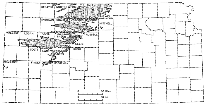
Figure 1--Map of Kansas showing outcrop (stippled) of Niobrara Chalk.
Previous Investigations
Kansas geological literature is filled with references to the Niobrara Chalk in general and to the Smoky Hill Member and its fauna in particular. Many of the papers contain trivial mention of the Smoky Hill or add little to understanding of the stratigraphy or paleontology of the unit. Only papers judged to contain significant additions to knowledge of the member are reviewed. No attempt is made to include summaries of the numerous articles that are concerned with vertebrate paleontology, although the principal contributors are named.
The earliest good description of the Smoky Hill Member is that of Engelmann (1858, p. 497, 498), whose investigations of Cretaceous strata along the Republican River included study of chalk beds shortly north of the Kansas-Nebraska border. He recorded the familiar upward gradation from dark- to light-colored chalk and opined that the white spots characterizing this chalk are "the exuviae of microscopic animals." Seventy-two years elapsed before these spots were mentioned by another worker. In the same year, Hayden (1858) published the first colored geological map of Kansas that included the Smoky Hill outcrop, but the Cretaceous was divided into only two map units, namely No. 1 (Dakota) and Nos. 2-3 (Benton plus Niobrara).
Despite clear recognition of the Kansas Niobrara before 1860, the first annual report on the geology of Kansas (Mudge, 1866, p. 10) states of the Cretaceous only that "chalk is said to have been found in it." All doubt about the existence in Kansas of Niobrara strata is dispelled in the report of LeConte (1868), in which the section of Smoky Hill strata exposed at Castle Rock (Gove County) and the upward gradation from gray beds to yellow beds that occurs along much of the Smoky Hill River Valley are described. LeConte's report also mentions occurrence of Ostrea congesta Conrad in the chalk. The distinction between a lower, dark-colored, usually thinner-bedded rock and an upper, yellow, more thickly bedded chalk was made also by Cope (1872, p. 325), who included a rhetorical essay on life in the sea during Niobrara deposition. His paper includes the earliest detailed account of Niobrara vertebrate fossils, and brief mention is made of bivalves, including a description of Haploscapha grandis Conrad (= Inoceramus (Volviceramus) grandis of this report) by Conrad. A short, more generalized account of the Niobrara, concentrating on the variety and preservation of vertebrate remains but also. mentioning the abundance of oysters and inoceramids, was furnished by Mudge (1875). The first microscopical study of chalk from the Kansas Niobrara was by Patrick (1875, p. 14), who noted the absence of microscopic organic remains and therefore pronounced the chalk a product of chemical precipitation. In the following year, Grinnell (1876) described the remarkable crinoid Uintacrinus socialis, which was first discovered in the Uinta Mountains but which, he noted, occurs also in Kansas strata now referred to the Smoky Hill Member. Shortly thereafter a supplementary description of Kansas specimens was published by Meek (1876).
Division of the Niobrara into members was first attempted by Mudge (1876). He gave the name "Niobrara proper" to beds now referred to the Smoky Hill Chalk Member. These strata are described in some detail, a thickness of 200 feet (61 m) is reported for Rooks County, and a discussion of fossils is included. He mentions occurrence of Ostrea congesta, a large undescribed bivalve (= Inoceramus (Platyceramus) platinus), and the presence of large rudists. This paper includes extensive comments on vertebrate fossils of the Smoky Hill Member. Expanded (but nearly identical) versions of this paper were published in subsequent years (Mudge, 1877, 1878) and include additional notes on Niobrara fossils. The latter (Mudge, 1878) includes the earliest illustration of the famous Monument Rocks of Gove County and the first crude graphic section that includes the Cretaceous section in Kansas.
Among the many early generalized accounts of the Niobrara, those of Hay (1885, 1889) are of especial interest because the 1885 paper includes the earliest description of replacement of weathered chalk by chert and the 1889 paper includes the first illustrations of Smoky Hill chalk that were made from photographs, including one of Castle Rock in Gove County. Also included in the latter paper is first mention of the fact that a large Inoceramus (= I. (Platyceramus) platinus) "is invariably covered by colonies of the small oyster, Ostrea congesta."
In a second article on microscopy of the Kansas chalk, Patrick (1883) credits a student, W. S. Bunn, with discovery of protozoan remains. He describes and illustrates several of these microscopic forms, which are, in fact, coccoliths. Several years later Williston (1890a, p. 249) reported that the chalk is composed almost wholly of coccoliths and rods, like those of the English Chalk, but that the sea was not deep because the Niobrara contains thick-shelled, and hence shallow-water, fossils such as Inoceramus and Rudistes. This article was followed shortly by another in which Williston (1890b) notes apologetically that W. S. Bunn was the first to discover coccoliths in the Kansas chalk. Dawson (1890, p. 276) hastened to point out that the Niobrara of Manitoba and Nebraska also contains abundant coccoliths, which are associated with foraminifers and rhabdoliths, and that he (Dawson, 1874) had described and illustrated these many years earlier.
Williston (1893) summarized briefly the history of investigations in the Kansas chalk country, and estimated the thickness of the Niobrara to be at least 430 feet (130 m), a figure which is far greater than had been supposed earlier. In this paper he correctly gives the dip of the chalk beds as north or northeast. Williston (p. 110) recorded for the first time the general stratigraphic distribution of invertebrate and vertebrate fossils and from his observations concluded that the sea became more shallow and the shorelines closer to western Kansas as deposition proceeded. He correctly ascribed the occurrence of Uintacrinus socialis to a stratigraphic position near the middle of the chalk sequence. A new and different classification of the Kansas Cretaceous was presented by Cragin (1896), who introduced several new names for units that were defined on lithologic criteria. The Niobrara was divided into Osborne Limestone, a name never adopted because the name "Fort Hays" had priority, and Smoky Hill Chalk. Although the name "Smoky Hill Chalk" is still in use in the sense of Cragin, Williston (1896) deplored Cragin's terminology, favoring instead the term "Pteranodon beds."
The first definitive descriptions of rock-stratigraphic units throughout the Kansas Cretaceous are by Logan (1897a). He reported (p. 220) a thickness of more than 300 feet (91 m) for "the Pteranodon beds, or Smoky Hill Chalk" and was first to note that the light-colored chalks are merely the weathered equivalent of the darker-colored, freshly exposed chalk. Logan also recorded the laminated appearance of some chalk beds and the abundance of chert that occurs in the upper part of the Smoky Hill at Norton, Kansas. In the same volume, Williston (1897) described the Niobrara, and especially the Smoky Hill Chalk, in considerable detail, covering such topics as subdivisions, thickness, structure, lithology, weathering of blue chalk to form the yellow chalk, erosional features and rates of erosion, invertebrate fauna, and vertebrate fossils. In this paper, first notice is given of numerous folds and faults that affected the formation. He mentions the great abundance of Ostrea congesta, the limitation of Haploscapha grandis to lower beds of the Smoky Hill, and the great size ("forty four by forty six or eight inches") of the thin-shelled inoceramid known today as Inoceramus (Platyceramus) platinus (Logan). Williston states erroneously that rudists occur only in the lower part of the Smoky Hill Member and correctly that ammonoids are represented almost exclusively by impressions. This paper includes first mention of Smoky Hill belemnites, which are said to be very sparse; a brief description of dibranchiates; and notice of a new cirriped species, Pollicipes haworthi ( = Stramentum haworthi (Williston) of the present paper). This important contribution, the most significant concerning the Smoky Hill Member to that date, also includes a summary of Niobrara vertebrates and their distribution.
In an introductory chapter of Kansas University Geological Survey Volume IV, Adams (1898) presented an historical account of studies concerning Upper Cretaceous strata of the State. This work is highlighted by a tabular summary of stratigraphic nomenclature that is modified and updated in Table 1 of the present report.
The last decade of the nineteenth century brought forth a flurry of scientific articles concerned with description of Kansas Upper Cretaceous fossils. During the years 1894 through 1901, numerous papers were concerned with additional discoveries and description of the crinoid Uintacrinus socialis Grinnell. Among the most important of these is that of Bather (1896), who summarized the history of discoveries and study, presented a very detailed description based on Logan County slabs in the British Museum Collection, and mentioned briefly the pelagic, free-swimming nature of these creatures. The definitive study, however, is that of Springer (1901), whose monograph includes discussion of collecting localities, stratigraphic horizons, mode of preservation, life habits, and systematic description. Additional features of the species were described by Martin (1908).
Up to 1897, only a few valid species of Smoky Hill macroinvertebrates had been described on the basis of Kansas material. These include Uintacrinus socialis (Grinnell), Stramentum haworthi (Williston), and Inoceramus (Volviceramus) grandis (Conrad). This list was expanded by Logan (1897b), who described species of the cirriped genera Stramentum and Squama and later (1898) monographed the known macroinvertebrates of the member in the classic, but outdated, Volume IV of the Kansas University Geological Survey. In this work, six new Smoky Hill species are described, of which only Inoceramus (Platyceramus) platinus (Logan), Durania maxima (Logan), and Tusoteuthis longa Logan appear valid. In this same volume are descriptions by McClung (1898) of chalk foraminifera and coccoliths, and first mention of the calcite that fills chambers of most Smoky Hill foraminifers. McClung notes (p. 426) that, aside from color, the Smoky Hill chalks "differ but little from the true English chalk." Only one new species of foraminifer is described. Further additions to the Smoky Hill invertebrate fauna appear in articles by Logan (1899a,b) in which a total of seven new species of Ostrea and the new genus Pseudoperna, with four new species, are described. Although the genus Pseudoperna is regarded as valid by Stenzel (1971), only two of these 11 new species, O. rugosa and O. exogyroides, have been accorded validity by later workers. In his final paper concerned with Cretaceous strata of Kansas, Logan (1899c) correlated the Pteranodon beds (= Smoky Hill Member) with the upper 125 feet (38 m) of the Apishapa beds of the Colorado Niobrara. In this work, he drew attention to the mollusk-bored wood, amber, charcoal, and pyrite nodules of the Smoky Hill beds.
A review of nineteenth century Smoky Hill vertebrate studies is beyond the scope of this report. Literature on the subject is very large and no summary is attempted here. A list of principal workers is sufficient, and particular works can be identified in the standard geological bibliographies. Among the more important contributors to knowledge of the vast Smoky Hill vertebrate fossil resources are E. D. Cope, Joseph Leidy, O. C. Marsh, S. W. Williston, and Alban Stewart.
During the first two decades of the twentieth century, the Smoky Hill Member of Kansas received scant attention, aside from papers concerning vertebrate paleontology. Renewed study of the Niobrara coincided largely with petroleum exploration efforts in the Great Plains, and during the next two decades (twenties and thirties) much effort was focused on the area of Smoky Hill outcrop. Description of Smoky Hill surface structure, especially in the type area, is included in a paper by Lupton and others (1922), who mentioned numerous anticlines and faults that characterize the chalk beds. Methods for mapping these structures were challenged by Twenhofel (1925), who believed the true structure differs considerably from that mapped, and who postulated differential compaction of underlying Dakota, Graneros, and Carlile shales as the principal cause of anomalous dips and faults in the chalk. Russell (1929) disagreed with the differential compaction hypothesis, favoring instead the development of these features by structural forces originating in the crust, with faults supposedly resulting from tensional adjustments associated with major north-south folds. The origin of faults in the Niobrara is treated at length by Rubey and Bass (1925), who also discussed the origin of folds in Late Cretaceous strata of the region.
The year 1925 marked the beginning of a period during which geologic maps and detailed reports of several counties that embrace parts of the Smoky Hill outcrop were published. Details of stratigraphy and paleontology are included in Kansas Geological Survey bulletins on Russell County (Rubey and Bass, 1925), Ellis County (Bass, 1926), Hamilton County (Bass, 1926), Mitchell and Osborne counties (Landes and Ockerman, 1930), Wallace County (Elias, 1931), and Ness and Hodgeman counties (Moss, 1932). None of these bulletins includes a description of a complete section of the Smoky Hill Member, but details of the unit prepared by Bass (1926), Elias (1931), and Moss (1932) are most noteworthy.
Bass (1926) demonstrated the utility of bentonitic clay layers and chalk layers of differing hardness as a tool for detailed physical correlation within the lower part of the unit. Lithologic character of the Smoky Hill bentonite seams was described by Pinkley and Roth (1928), who noted the nearly uniform spacing of seams and suggested their usefulness in structural mapping and precise correlation of strata: A complete measured section of the Smoky Hill, based on surface sections, was published by Russell (1929), and groups of distinctive bentonites, each designated by a letter, were defined as key intervals for detailed correlation. However, Russell's section lacks lithologic detail, includes several intervals for which no data are given, and is on a scale that greatly limits its utility. Furthermore, many of the useful markers, other than bentonites, are not mentioned. Russell (1929, p. 603) emphasized the errors in stratigraphic measurement that can result from improper understanding of local structural relationships in the formation.
General features of Cretaceous stratigraphy and surface structure on a county-by-county basis are incorporated in a summary of western Kansas oil and gas resources by Ver Wiebe (1938) and Niobrara stratigraphy and surface structure are discussed in somewhat greater detail in a later oil and gas resources report concerned specifically with Logan, Gove, and Trego counties (Landes and Keroher, 1939).
In 1937, a program of cooperative groundwater investigations in Kansas was initiated by the Kansas Geological Survey and the U. S. Geological Survey. A long and continuing series of Kansas Geological Survey bulletins, most of which treat the geology and groundwater resources of individual counties, has resulted from this effort. Several of these bulletins are concerned with counties lying at least partly within the Smoky Hill outcrop and three, by Johnson (1958), Hodson and Wahl (1960), and Hodson (1965), cover Logan, Gove, and Trego counties, respectively. These bulletins contain brief descriptions of the Smoky Hill Member and are accompanied by useful maps.
For several years, beginning in 1947, the U. S. Geological Survey issued a series of circulars concerned with evaluation of construction materials of Kansas counties. Several of these circulars contain information on counties lying at least partly in the Smoky Hill outcrop, including generalized stratigraphic descriptions of the member, representative measured sections, and use of the rock for such purposes as road metal, riprap, calcareous binder, and structural stone. The Smoky Hill type area is treated specifically in circulars by Byrne and others (1947, 1949).
More recent studies of Smoky Hill invertebrate paleontology began with the work of Withers (1926), who described a new species of cirriped, Calantica (Titanolepas) martini, from Gove County. Morrow (1934, 1935) recorded foraminifers and cephalopods of the member and described one new foraminiferal species. Comprehensive treatment of the Colorado Group invertebrates, including those from the Smoky Hill, are included in an unpublished Ph.D. thesis by Morrow (1941). A more thorough investigation of Niobrara foraminifers was conducted by Loetterle (1937), who recorded 14 species, four of them new, in the Smoky Hill. More recently, Frerichs and Dring (1981) described stratigraphic occurrence of approximately 36 species of planktonic foraminifers from eight exposures of the Smoky Hill Member in Trego, Gove, and Logan counties. Although their sections are purported to comprise a composite section, two of the sections are almost identical and significant thicknesses of the member are not represented. Furthermore, their Orion, Gove, and Chalk Butte sections do not crop out at localities designated on the map that accompanies their paper. Fossil pearls from the Smoky Hill Member have been described in detail by Brown (1940) and are attributed to the genus Inoceramus. Fischer and Fay (1953) describe a new species of ammonite operculum, Spinaptychus sternbergi, more recently interpreted as a jaw apparatus, several specimens of which were collected from the member by the late George F. Sternberg. Smoky Hill coleoid cephalopods, including belemnoids and teuthids, have attracted considerable attention in recent years, and several papers (Jeletzky, 1955, 1961; Miller, 1957a,b; Miller and Walker, 1968; Green, 1974, 1977) have resulted from studies of these cephalopods. Locality data for the crinoid Uintacrinus socialis have been well documented in a paper by Miller and others (1957). This work is of especial importance because crinoid-rich slabs, such as seen in museums, are now exceedingly hard to locate in the field. Extensive stratigraphic and paleontologic work on the Niobrara by Miller (1958) resulted in a doctoral dissertation, parts of which were published in a work (Miller, 1968) that includes description of the Smoky Hill macroinvertebrate fossils known to date. This important paper contains the description of a new species of Pecten. Additional data on the Niobrara invertebrates, including new records of Smoky Hill fossils, were published subsequently by Miller (1969). Diachroneity of chalky limestone and chalk in the lower part of the Niobrara was demonstrated by the author (Hattin, 1975a) in a paper that documents occurrence of I. (Volviceramus) grandis, a typical lower Smoky Hill species, in Smoky Hill strata of Kansas but near the base of the Fort Hays Limestone Member in northeastern Nebraska. Most recently, I (1977a) have discussed and illustrated Smoky Hill stramentid cirripeds, re-evaluated the family Stramentidae, and suggested that the Smoky Hill genus Squama is not valid.
Macroinvertebrate paleontology and stratigraphy of the Niobrara has been described comprehensively by Scott and Cobban (1964) in a work concerned with the excellent section exposed along the Arkansas River at Pueblo, Colorado. Although not treating Kansas strata or fossils specifically, this work is a major contribution to knowledge of the Smoky Hill and deserves special mention here.
Correlation of Kansas Cretaceous formations with other units of the Western Interior Region is presented in the classic paper by Cobban and Reeside (1952). Subsurface correlation of Cretaceous units in Kansas is depicted in several cross sections prepared by Merriam (1957).
Maps showing thickness and general character of Cretaceous deposits in the U. S. Western Interior were prepared by Reeside (1944) and include a thickness map for the Niobrara and equivalent strata. Reeside (1957) also prepared a series of lithofacies maps for each of several Cretaceous time intervals, including that of the Smoky Hill, to accompany a text in which broad outlines of depositional environment and paleoecology are discussed. In an important work that summarizes the geologic history of Kansas, Merriam (1963) has included a brief description of the Smoky Hill, has incorporated several photographs of erosional features in the chalk, and has also presented a structure contour map based on the top of the Niobrara and an isopachous map of the entire formation. Specific features of Smoky Hill paleoecology and depositional environment are included in a series of field trip guidebooks prepared in connection with meetings of the Geological Society of America, North American Paleontological Convention II, and AAPG-SEPM (Hattin, 1965, 1977b; Hattin and Siemers, 1978).
Until recently, few papers were devoted to petrologic investigations of the Smoky Hill chalk. A few photomicrographs were included by Miller (1968) in his major published work on the Niobrara invertebrate fauna. Scanning electron micrographs of samples from the Smoky Hill Member of Kansas are included in general studies of chalk diagenesis by Neugebauer (1973, 1974, 1975a,b). Petrologic character and origin of coccolith-rich Smoky Hill fecal pellets are analyzed in a recent work by the author (Hattin, 1975b), who included photomicrographs and scanning electron micrographs of pellets and enclosing chalk matrix. In an excellent synthesis of chalk diagenesis, Scholle (1977) included discussion of the Niobrara Chalk, especially the Fort Hays Member, and concluded that slight cementation is owing principally to relatively shallow burial depths. Petrologic and physical properties of the gas-producing Beecher Island zone of the Smoky Hill Member have been described and illustrated by Lockridge and Scholle (1978) in a paper concerned with Niobrara gas in northeastern Colorado and northwestern Kansas. Neugebauer (1978a) has presented a thorough analysis of diagenesis in the thin lenses of Uintacrinus limestone, including micritization by dissolution, compaction, and cementation. In a subsequent paper, Neugebauer (1978b) addresses the problem of inoceramid bivalve preservation in chalk deposits, including the Niobrara, although he does not specify whether or not any of the studied specimens are from the Smoky Hill Member. Additionally, Neugebauer and Ruhrmann (1978) have studied the syntaxial overgrowth of diagenetic calcite on echinoderms and included an illustration of such calcite in the stereom of a Smoky Hill Uintacrinus specimen. I (Hattin, 1981) have undertaken a comprehensive analysis of Smoky Hill chalk petrology and origin, which is based on samples from throughout the member and differentiates several varieties of carbonate rock within the section.
Except for diagenetic studies of Smoky Hill chalk cited above, geochemical studies of the unit are few indeed. Amino acid composition of fish, bivalve, and cephalopod remains has been reported by Matter and Miller (1972), who also noted organic content of gray, presumably little weathered, chalk as great as 5.6 percent. Honjo and Tabuchi (1970) report the minor element composition of a large series (73) of Smoky Hill chalk samples, but unfortunately their work does not contain any discussion or conclusions of analytical results, and a promised sequel apparently has yet to be published. Most importantly, Arthur and others (1981) have presented (poster session) a detailed environmental analysis of the Colorado and Kansas Niobrara that is based largely on isotopic analysis of the chalk.
The current gas play in Smoky Hill strata of northeastern Colorado, southwestern Nebraska, and northwestern Kansas has been mentioned in several recent issues of scientific and trade journals. Characteristics and biogenic origin of the Niobrara gas have been discussed by Rice and Claypool (1981, p. 14). Finally, Hann (1981) has presented a stratigraphic analysis of the Niobrara Formation in the Denver Basin, with especial emphasis on petroleum potential. Her work contains numerous references to the Kansas section and includes a useful regional correlation chart.
Location and Description of the Area
Geography
In Kansas the principal Niobrara outcrop trends almost exactly northeastward from its southern terminus in north-central Finney County to the Nebraska border in northeastern Jewell County. This outcrop is 306 km (190 mi) in length along its eastern edge and reaches maximum width, measured normal to the northeasterly trend, of approximately 97 km (60 mi) on a line extending from south-central Osborne County to west-central Phillips County (Fig. 1). In places the Niobrara outcrop is less than 0.4 km (1/4 mi) in width. From the main part of the outcrop, major westward extensions of the formation occur along drainage systems of the Smoky Hill River, Saline River, and the north and south forks of the Solomon River. In Smoky Hill River country, the outcrop extends almost without interruption for a distance of 196 km (122 mi) adjacent to a line at 30° 52' north latitude, from a point shortly southwest of Hays Kansas, to a point situated in east central Wallace County (Fig. 1). Southwest of the main outcrop, in Hamilton County, the Niobrara crops out as small inliers along south-flowing intermittent streams tributary to the Arkansas River. The formation also crops out along Sappa Creek, in Decatur and Norton counties, and along Prairie Dog Creek in Norton and Phillips counties, as southwestward extensions of the Nebraska Niobrara outcrop (Fig. 1). Altogether, the Niobrara crops out in parts of 23 Kansas counties (Fig. 1).
Natural exposures of the Niobrara Chalk are too abundant to enumerate fully. The best known and most-visited exposures are along the valley of the Smoky Hill River and its tributaries, but excellent exposures occur also along the Saline River, both forks of the Solomon River, and along White Rock Creek in Jewell County. Construction of roads, especially those running north-south, has in many places produced excellent artificial exposures, especially of the Fort Hays Limestone Member.
Along the Smoky Hill River and its tributaries topography includes broad, gently sloping outer valley walls (flanking pediments), steep bluffs and cliffs held up by the Niobrara Chalk, and nearly flat to extensively dissected uplands. Hilly terrain developed adjacent to water courses is devoted almost exclusively to cattle ranching. Level bottom land, upland surfaces, and gently sloped flanking pediments are mostly farmed. Wheat is the principal grain crop; sorghum is second in importance. Minor grain crops include corn, oats, barley, and rye. Hay and alfalfa are grown extensively. Except for cottonwood and willow, which are distributed patchily along most water courses, and a variety of juniper ("cedar" of local parlance) that occurs here and there along chalky cliffs overlooking Smoky Hill River and its tributaries, the region is largely treeless, and sweeping vistas are afforded from edges of the upland surface.
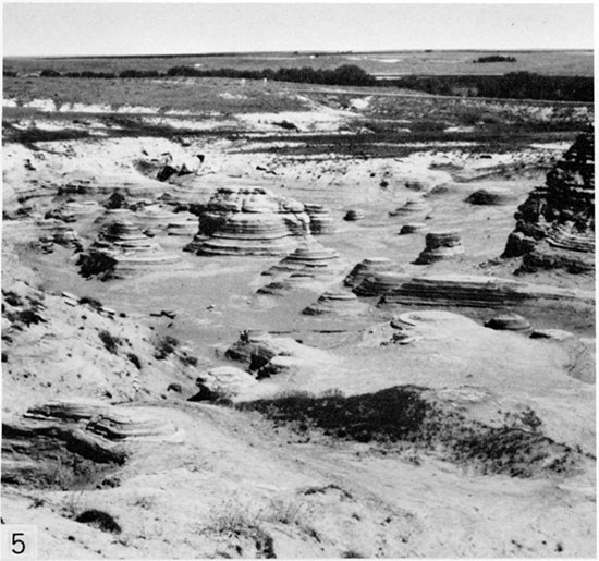
Erosion of the Niobrara has produced rock pinnacles, monuments, badlands and cliffs, which create fascinating scenery through much of the Smoky Hill drainage area (Figs. 2-5). Notable landmarks are Cedar Bluff, Trego County (Fig. 2); Wildcat Canyon (Sec. 16, T. 14 S., R. 25 W., Trego County); Castle Rock, Gove County (Fig. 3); Little Castle Rock (Sec. 17, T. 15 S., R. 26 W., Gove County); Monument Rocks and the Sphinx (Secs. 33 and 34, T. 14 S., R. 31 W., Gove County); Chalk Bluff, Logan County (Fig. 4); Little Pyramids (Secs. 11 and 14, T. 15 S., R. 33 W., Logan County); and Goblin Hollow, Logan County (Fig. 5). This listing is not meant to detract from the very large number of other erosional features, including many unnamed cliff and badland areas, which afford so much delight to visitors.
Figure 2, Cedar Bluff and Cedar Bluff Reservoir, looking east from Sec. 6, T. 15 S., R. 22 W., Trego County, Kansas. The cliff is developed along a westward reentrant of the Fort Hays escarpment, and is held up by the Fort Hays Member, Niobrara Chalk.
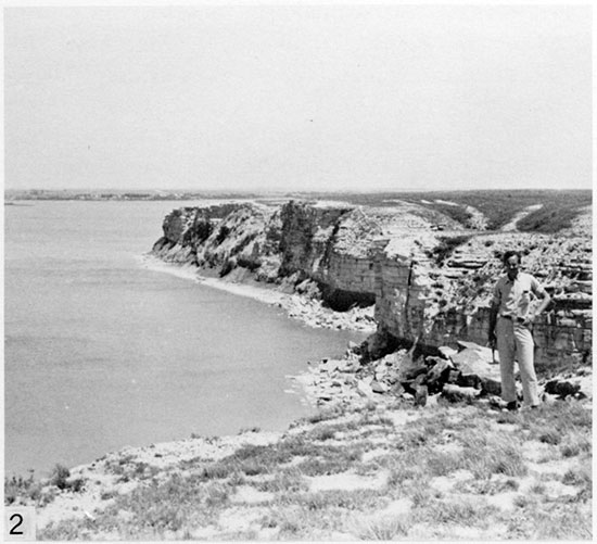
Figure 3, Famous exposure of Smoky Hill Member at Castle Rock, in Sec. 1, T. 14 S., R. 26 W., Gove County, Kansas. Note prominent caprock-forming unit at top of two pinnacles at left.
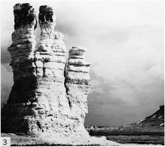
Figure 4, Erosional pinnacles at Chalk Bluff, Sec. 25, T. 14 S., R. 33 W., Logan County, Kansas. Note caprock-forming unit at top of taller pinnacle.
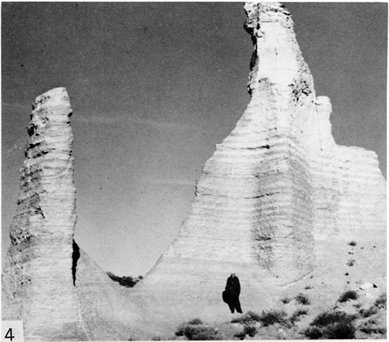
Figure 5, Exposure of Smoky Hill chalk at Goblin Hollow, Sec. 27, T. 13 S., R. 35 W., Logan County, Kansas.
General Geology
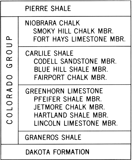
The Niobrara Chalk has long been classified as part of the Colorado Group, which in Kansas is subdivided as shown in Figure 6. Throughout the Kansas outcrop, Niobrara strata lie disconformably on the Carlile Shale (Hattin, 1975a). In the upper reaches of the Smoky Hill River, and locally along Prairie Dog Creek in northwestern Phillips County, the formation is overlain conformably by the Sharon Springs Member of the Pierre Shale. Elsewhere the Niobrara is overlain disconformably by the Ogallala Formation (Miocene and Pliocene) at a contact that truncates the formation from west to east, or by unconsolidated Quaternary deposits. The main part of the Niobrara outcrop lies in northcentral and western Kansas, and underlies the eastern edge of the High Plains physiographic province (Schoewe, 1949, p. 276). The eastern edge of this province is marked by the Fort Hays (or Niobrara) escarpment, which is a bold topographic feature (Fig. 2) along major streams but has only subdued relief in interstream areas. The regional trend of this escarpment is nearly northeast, with major invaginations at each major stream where cliffs held up by the Fort Hays Member extend for many miles upstream in a generally westward direction. The escarpment is especially prominent along the Saline River in northern Ellis County and the Smoky Hill River in Trego County. Maximum relief along the escarpment is along the Saline River, where local relief is approximately 91 m (300 ft) in the Bemis-Shutts oil field area. Along the Smoky Hill River local relief is a maximum of 61 m (200 ft) in southeastern Trego County, near Cedar Bluff Dam. East of the main escarpment prominent buttes and mesas, capped by outliers of the Niobrara, are scattered along the area of Carlile Shale outcrop. Especially noteworthy are the Blue Hills of southwestern Mitchell County and a large number of similar hills in southeastern Osborne County.
Figure 6--Stratigraphic classification of Upper Cretaceous rocks in west-central Kansas.
In the type area the Smoky Hill Member contains few beds with erosional resistance that matches that of the Fort Hays Member. A group of bioturbated limestone beds, lying approximately 25 m (85 ft) above the base of the Smoky Hill, forms conspicuous low cliffs along Hackberry Creek and the Smoky Hill River in western Trego County. A thick unit of nearly massive chalk, lying 88.5 m (290 ft) above the base, forms the prominent caprock at Castle Rock (Fig. 3) and Monument Rocks in Gove County and is the caprock at Little Pyramids and Chalk Bluff (Fig. 4) in Logan County. These more resistant beds are scarcely evident in little-weathered exposures but form benches and overhanging, lichen-splotched ledges where highly weathered. A similar unit of nearly massive chalk lies near the top of the Smoky Hill elsewhere in Logan County but is less well exposed than that forming cap rock on familiar landmarks of Smoky Hill River country. These major, resistant units correlate physically with the lower limestone unit and with the middle and upper chalk units, respectively, of the section at Pueblo, Colorado (Scott and Cobban, 1964). Numerous thinner, apparently bioturbated beds of tough chalk, which occur primarily in the upper half of the member, also form caprocks on erosional features, but on a much smaller scale.
Full thickness of the Smoky Hill is not exposed at any one locality in Kansas; rather, the section must be pieced from numerous exposures scattered across the outcrop. Mostly gentle dips, limited stratigraphic extent of individual exposures, mostly gentle topography, and locally extensive faulting make measurement of complete sections a major task. Composite sections of the entire Smoky Hill have been compiled only for Graham County (Virgil Cole, oral communication, 1962) and along the Smoky Hill River and its tributaries in southwestern Trego, Gove, and Logan counties. The latter comprises the type area of the Smoky Hill Member and the section exposed therein comprises the basis for this report.
The Smoky Hill composite section described here is based on natural exposures consisting of cliffs and badlands along the Smoky Hill River and several of its named and unnamed tributaries. At each of three localities (Pl. 1, Locs. 13, 19, 23), approximately 29 m (95 ft) of section were measured, but such extensive exposures are not numerous. Along Hackberry Creek (Pl. 1, Loc. 1) a section including the Fort Hays and lower part of the Smoky Hill Member is 38.3 m (125.6 ft) thick. This is apparently the thickest continuously exposed Niobrara Chalk section in the State.
In the Smoky Hill River area, structure at the base of the Niobrara is essentially a north to northeastwardly dipping homocline, with dip of approximately 3.5 m (11. 7 ft) per kilometer to the northeast in Logan County, and approximately 2.3 m (7.3 ft) per kilometer slightly east of north in Gove County (based on Merriam, 1963, fig. 108). Anomalous dips occur locally, where small domal and anticlinal structures are reflected at the surface in Niobrara strata. Greatest reported concentration of these features is along the Smoky Hill River and its tributaries in Gove and Logan counties, where Lupton and others (1922) identified 18 structures of which at least eight are closed, with closure ranging from 15.2 m to 45.7 m (50-150 ft). In an analysis of some such features Twenhofel (1925, p. 1066) concluded that methods used to map several of these structures were inaccurate and the true structure bears little resemblance to that shown on maps.
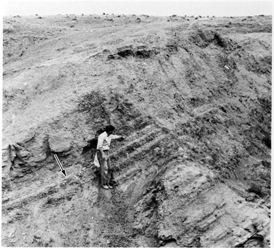
Anomalous dips in Smoky Hill strata also occur adjacent to normal faults (Fig. 7), which have been recorded in abundance throughout the outcrop (e.g., Johnson, 1958, p. 30; Bass, 1926, p. 44; Prescott, 1955, p. 47). Although most of the faults are only a few hundred meters in length and involve little stratigraphic displacement, Johnson (1958, p. 30) mapped one Logan County fault that is 5.6 km (3.5 mi) long and believed that some fault displacements may be as much as 61 m (200 ft). In the field these faults are recognized readily, not only because of anomalous dips in adjacent strata (Fig. 7) and obvious stratigraphic displacement, but also because most are marked by masses of slickensided calcite, which litter the ground adjacent to faults or hold up elevated ridges along fault traces owing to differential erosion. Origin of these faults is uncertain but their erratic pattern and irregular distribution seem unrelated to regional structure. At a single elevation above sea level, chalk on either side of a fault may be weathered to greatly differing degrees, suggesting that faulting occurred after an episode of extensive weathering and that erosion later stripped the resulting much-weathered rock from the upthrown block, leaving only less-weathered rock situated beside highly weathered chalk of the downdropped block.
Figure 7--Exposure of uppermost part of Smoky Hill Member and lowermost part of Pierre Shale, Sec. 20, T. 15 S., R. 32 W., Logan County, Kansas. Cal James is pointing to the contact. Arrow indicates Marker Unit 23. Anomalous dip of strata owing to proximity of strata to a major normal fault.
Chalk of the Smoky Hill Member has been quarried in many places for use as building stone (Risser, 1960, p. 89). Rock from the Smoky Hill has been used also for the manufacture of whiting. Smoky Hill strata have relatively low permeability and the unit is generally unsatisfactory as an aquifer. In the past quarter century the Smoky Hill has become a target for natural-gas drillers. Merriam (1958, p. 138) noted gas production from the basal Pierre and upper part of the Smoky Hill in the Goodland field (discovered 1938) at a depth of 1100 feet (335 m). Details of the productive horizon, the Beecher Island zone, which actually lies shortly beneath the Smoky Hill-Pierre contact, have been presented by Lockridge and Scholle (1978). The producing interval is approximately 6 to 15 m (20-50 ft) thick and has low permeability, but shallow depths and good prices have initiated a fair-sized play in the area. Additional note of this play, and its spread into northwestern Kansas, is made by Harris and Larsh (1979, p. 342).
In the Smoky Hill drainage basin, thickness of the Niobrara ranges widely. Johnson (1958, p. 36) reports a maximum thickness of 210 m (690 ft) in Logan County, and Hodson and Wahl (1960, p. 64-65) indicate about 203 m (665 ft) in northwestern Gove County. Farther north the formation has a maximum thickness of 184 m (605 ft) in Graham County (Prescott, 1955, p. 46-47) and 198 m (650 ft) in Phillips County (Landes and Keroher, 1942, p. 286), adjacent to the Nebraska border. For the Smoky Hill Member some reported thicknesses are as follows: western Logan County, 168 m (550 ft) (Landes and Keroher, 1939, p. 23); Gove County, 183 m (600 ft plus) (Hodson and Wahl, 1960, p. 65); and Graham County, 183 m (600 ft) (Landes and Keroher, 1942, p. 286). According to Merriam (1957, p. 14), the Smoky Hill ranges in thickness from 122 m (400 ft) to more than 198 m (650 ft) along lines of cross sections prepared for the Kansas Mesozoic. In the composite section of the present report, based on field work in Trego, Gove, and Logan counties, thickness is 181.8 m (596.3 ft); however, marker-defined intervals have different thicknesses in sections separated by only a few kilometers, so the stated thickness is representative, rather than actual.
Prev Page--Contents || Next Page--Nomenclature
Kansas Geological Survey, Geology
Placed on web Feb. 20, 2015; originally published Dec. 1982.
Comments to webadmin@kgs.ku.edu
The URL for this page is http://www.kgs.ku.edu/Publications/Bulletins/225/02_intro.html