![]()
Prev Page--Nomenclature || Next Page--Biostratigraphy
Stratigraphy of the Smoky Hill Chalk Member
Lithology
Stratified Chalk.
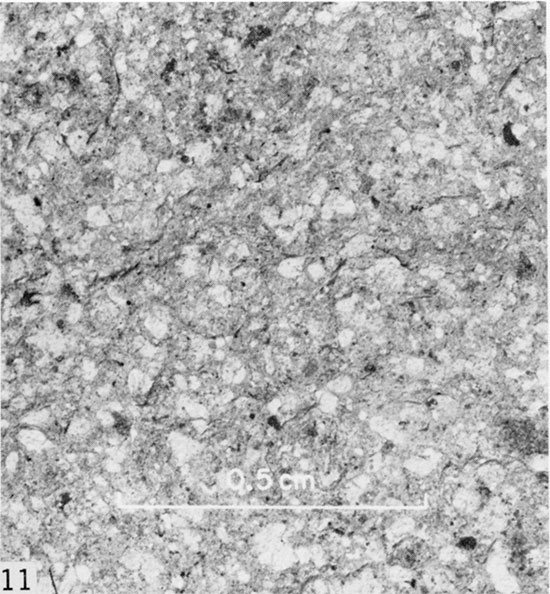
The Smoky Hill Member consists primarily of obscurely to well laminated, fissile, mostly white-speckled, shaly weathering chalk, which is predominantly olive gray (5Y4/1) and less commonly dark olive gray (5Y3/1) or olive black (5Y2/1) in color where least weathered. Partly weathered rock is lighter colored, being mostly medium olive gray (5Y5/1, 5Y4/2) or light olive gray (5Y6/1, 5Y5/2). Much-weathered chalk manifests wide color range, including very pale orange (10Y8/2) through dark yellowish brown (10YR4/2), pale grayish orange (10YR8/4) through moderate yellowish brown (10YR5/4), and pale yellowish orange (10YR8/6) through dark yellowish orange (10YR6/6) (colors from Goddard and others, 1948). Freshly exposed laminated chalk is tough, forms steep faces in cutbanks of streams, and has characteristically spally fracture. Much of the rock, especially in the lower half of the member, is thinly laminated (Fig. 10) but on gentle slopes and in highly weathered sections this feature is not everywhere obvious. Laminations are on a millimeter to centimeter scale. Units that lack obvious lamination in weathered exposure are usually observed to be moderately to well laminated in fresh exposure, as along cutbanks in gullied badlands. Lamination is owing primarily to vertical variations in abundance of fecal pellets (Hattin, 1975b), which have been compacted to oblate spheroidal shape and, because of great abundance, enhance fissility of the rock (Fig. 11).
Figure 10--Exposure of Smoky Hill Member in Sec. 16, T. 15 S., R. 34 W., Logan County, Kansas, showing well-laminated character of chalk.
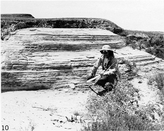
Figure 11--Plan view of bedding surface of well-laminated chalk, showing abundance of coccolith-rich fecal pellets (light-colored grains). X 8. Sample from lower part of Smoky Hill Member in Sec. 16, T. 14 S., R. 25 W., Trego County, Kansas.
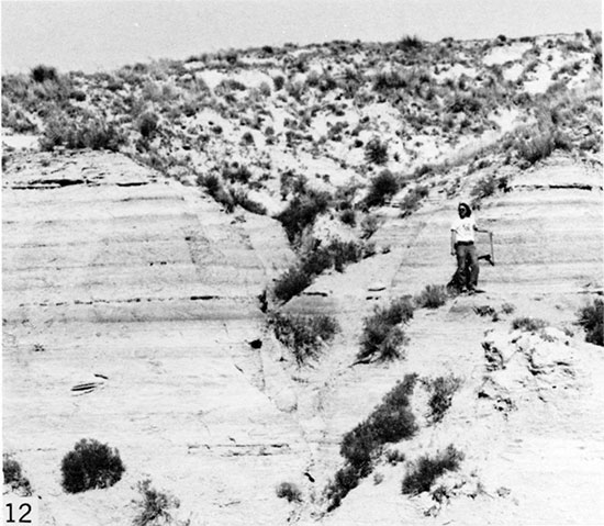
The upper half of the member, especially in the interval extending from 130 to 177 m (426-580 ft) above the composite section base, contains numerous beds of chalk that are neither bioturbated nor obviously laminated. Nevertheless, this chalk splits readily parallel to the general stratification and contains an abundance of fecal pellets. Throughout the section, beds that are well laminated are gradational with those that are obscurely laminated, which in turn are gradational with those lacking obvious lamination. Beginning at a horizon lying approximately 62 m (203 ft) below the top of the member, many units of shaly weathering chalk have thinly crinkled structure rather than lamination, and beds having this characteristic persist, with highly irregular spacing, to within 3 m (10 ft) of the Smoky Hill-Pierre contact. Alternation of darker, crinkled beds with lighter-colored beds of granular chalk (see below) produces a distinctly rhythmic stratification, most notably in the interval extending from 116 to 139 m (380-455 ft) above the Fort Hays-Smoky Hill contact (Fig. 12).
Figure 12--Exposure of rhythmically stratified alternations of lighter-colored, granular chalk and darker-colored, crinkly chalk in Sec. 30, T. 15 S., R. 32 W., Logan County, Kansas.
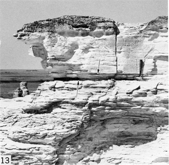
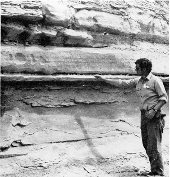
Weathered shaly chalk is friable, softer than little-weathered chalk, and breaks readily into small chips or flakes, which litter eroded slopes. In exposures where weathering has been most extensive the chalk may form relatively resistant ledges or cliffs of chalk that appears to be massive but splits readily along flat stratification planes that reflect original lamination (Fig. 13). Alteration of rock during weathering tends to obliterate lamination and causes thinning of units by as much as one third in exposures separated by just tens of meters from equivalent, unweathered rock.
Figure 13--Bed (top of photo) of highly weathered, massive-looking chalk in Sec. 1, T. 14 S., R. 26 W., Gove County, Kansas. Rock splits easily along flat planes of bedding, but original laminations have been largely obliterated by weathering. Hammer is 28 cm (0.9 ft) long. Arrows indicate weathered bentonite seams, which comprise Marker Unit 12.
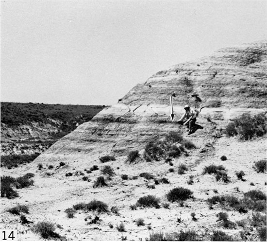
A few intervals of mostly well laminated chalk contain conspicuously darker beds, which form prominent bands across little-weathered exposures (Fig. 14). Such beds are as much as 1. 2 m thick. Four major beds of this kind lie in the interval 34 to 133 m (112-436 ft) above the base of the Smoky Hill in the composite section and are yellowish brown (10YR5/2) to dark yellowish brown (10YR4/2) in partly weathered exposures, which are most common. At one locality (Loc. 23, see Fig. 14) the next to uppermost of these four beds contains 5.8 percent organic carbon.
Figure 14--Dark-colored band (arrow) of organic-rich chalk in Sec. 12, T. 15 S., R. 32 W., Logan County, Kansas. The organic-rich band is part of Marker Unit 14 and can be identified readily by its association with the light-colored band of granular chalk, which lies shortly above.
Bioturbated Chalk.
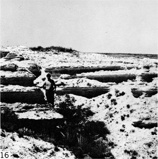
Scattered irregularly through the Smoky Hill member are beds of mostly light olive gray (5Y2/1), resistant, nonlaminated chalk, which forms light gray to very light gray bands on little-weathered exposures (Fig. 15). In the lower 95 m of the Smoky Hill such beds contain clear evidence of bioturbation, especially including deposit-feeder burrows referable to Planolites Nicholson. Bioturbated intervals range in thickness from a few centimeters to 30 or 40 cm (1.0-1.3 ft). Complete gradation exists between intervals in which bioturbation was extensive, and destroyed all traces of lamination, and those which were burrowed only partially and which preserve some or most of the primary lamination. Where least weathered, such beds form small shoulders or weakly developed benches on eroding slopes, and produce abundant brittle chips or small plates of irregularly fractured rock. In extensively weathered exposures these bioturbated beds exhibit the same color range as adjacent beds of well-stratified chalk, but are more resistant to erosion and form distinctive benches and overhanging ledges that are recognized readily (Fig. 16). These lighter-colored, bioturbated beds are especially useful as stratigraphic markers, and several of them are described in detail below.
Figure 15--Bed (arrow) of bioturbated chalk in Sec. 1, T. 14 S., R. 26 W., Gove County, Kansas. Allen Archer's hands are on two nearby bentonite seams, which together with the bioturbated chalk bed and associated chalk comprise Marker Unit 9.
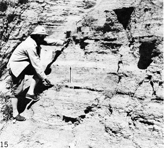
Figure 16--Resistant, ledge-forming beds of bioturbated chalk in Sec. 16, T. 14 S., R. 25 W., Trego County, Kansas. These beds comprise Marker Unit 3.
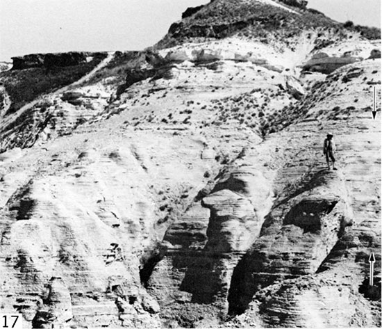
An important example of partially bioturbated rock, which lies 88.4 m (290 ft) above the composite section base and is 6.7 m (22 ft) thick, is tough, poorly stratified compared with adjacent chalk beds, and forms prominent buttresses in little-weathered exposures (Fig. 17). This rock is gradational with laminated chalk and highly bioturbated chalk, and has a somewhat granular texture like rocks described in the next paragraph. The unit is the major caprock of erosional pinnacles and badlands in Gove and eastern Logan counties (Figs. 3, 4). Where least weathered this rock is medium olive gray (5Y5/1) and highly speckled throughout by fecal pellets.
Figure 17--Buttress-forming, partially bioturbated chalk of Marker Unit 10 in Sec. 1, T. 14 S., R. 26 W., Gove County, Kansas. This unit is the principal caprock in chalk badlands of Cove and Logan counties. Note that the buttress-forming unit (between arrows) is less well stratified than beds below.
Granular Chalk.
In the upper half of the Smoky Hill Member most beds of tough, more resistant, lighter-colored, poorly to non stratified chalk have a somewhat granular texture, which is in marked contrast to that of adjacent, shaly weathering chalk beds. When viewed at a distance, some of these beds manifest thinly stratified appearance. Stratigraphic intervals consisting of granular chalk range from a few centimeters to as much as 0.76 m (2.5 ft) in thickness. This rock is apparently of similar origin to the bioturbated beds in the lower half of the member, but recorded burrow structures are sparse, very small, and detected mostly in thin sections. Granular chalk tends to form smoothly rounded shoulders on eroding slopes, and is a bench-forming caprock in much-weathered badlands. Where least weathered, the granular chalk is olive gray (5Y4/1) but the rock is more commonly medium olive gray (5Y3/1) to light olive gray (5Y5/2) and forms light-colored bands on the outcrop that stand out conspicuously against the background of adjacent, darker-colored stratified chalk (Figs. 12, 14). In highly weathered exposures the rock usually manifests a wide range of coloration, much the same as well-stratified chalks, but locally, near the top of the member, some such beds weather to moderate reddish orange. Granular chalk usually contains only sparse, fragmentary macroinvertebrate fossils but is highly speckled by nearly white fecal pellets.
Bentonite.
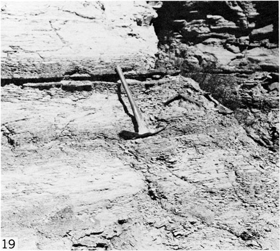
Bentonite seams are a characteristic feature of Smoky Hill stratigraphy, and are scattered throughout the section (Fig. 18). The bentonites range in thickness from less than one mm to as much as 11.3 cm (0.37 ft). Bentonite color ranges widely, depending mostly upon the degree of weathering and partly on original mineral composition. Least-weathered seams are olive gray (5Y4/1), light olive gray (5Y6/1), medium gray (N5), and medium light gray (N6), with rare occurrences of light bluish gray (5Y7/1) and medium greenish gray (5GY6/1). Weathered bentonite is, in order of decreasing commonness, dark yellowish orange (10YR6/6), light brown (5YR5/6), very pale orange (10YR8/2) through dark yellowish brown (10YR4/2), yellowish gray (5Y8/1, 5Y7/2), and pale grayish orange (10YR8/4) through moderate yellowish brown (10YR5/4). Weathering colors of minor occurrence include pale shades of olive, gray, brown, yellow, and white, and for one seam only, pale grayish orange pink (5YR8/2). Most of the orange and brown coloration is owing to iron oxides, which nearly everywhere stain the more weathered seams. Iron mineralization has occurred in the form of oblate spheroidal marcasite nodules, as much as 0.7 m (2.3 ft) wide and 12 cm (0.4 ft) thick, usually altered to iron oxide, and as laterally continuous crusts (Fig. 19), which bound certain bentonite seams in some exposures and are as much as 3 cm (0.1 ft) thick. Gypsum has developed commonly as seams that bound the individual bentonite beds, and occurs also as fine powder, sand-sized crystals, or coarsely crystalline crusts in which selenite C axes are normal to bedding. Gypsum and iron oxide co-occur along many weathered bentonite seams. In the Smoky Hill composite section described below, more than 100 bentonite seams were identified. Yellowish-colored jarosite is also associated with iron oxide and gypsum along many of the weathered bentonite seams. Numerous seams consisting of iron oxide, commonly with associated gypsum, and usually less than 6 mm (0.02 ft) thick, probably represent highly weathered, originally very thin bentonite seams.
Figure 18--Bentonite seams (arrows) separated by weathered chalk, Sec. 30, T. 15 S., R. 32 W., Logan County, Kansas. The two bentonite seams and intervening chalk comprise Marker Unit 18.
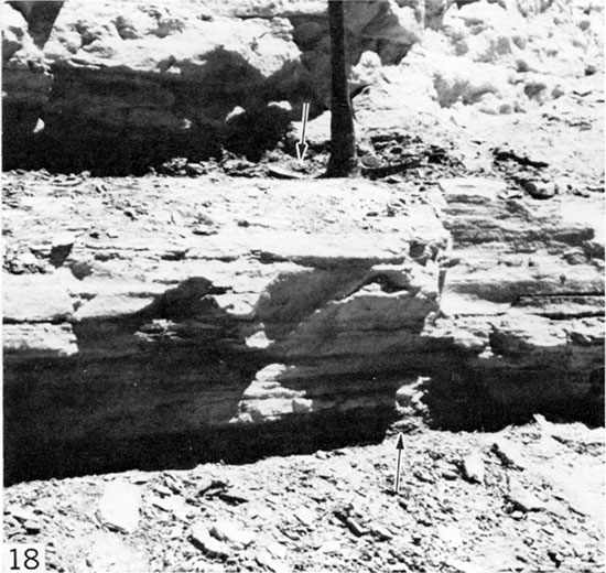
Figure 19--Bentonite seam bounded by resistant crusts of iron oxide, Sec. 30, T. 15 S., R. 32 W., Logan County, Kansas. Hammer is 28 cm (0.9 ft) long.
Thirty-five bentonite samples were analyzed by X-ray diffractometry. These samples, from 10 different localities, are representative of bentonite seams from most of the Smoky Hill composite section. In 23 samples the dominant clay mineral is kaolinite, whereas in nine samples the dominant mineral is smectite. In some kaolinite-dominated samples, smectite occurs as an accessory clay mineral, and vice versa. Quartz, usually in minor quantity, is an accessory mineral in 20 of the samples, occurring in both kaolinite- and smectite-dominated bentonites. Gypsum and calcite are the only other accessory minerals recorded commonly, and gypsum is the dominant mineral in two highly weathered bentonite seams in which no clay minerals were recorded.
Bentonite stratigraphy, including details of sequence, thickness of individual seams, clustering of seams within small stratigraphic intervals, and association with bioturbated or granular chalk beds was of primary importance in piecing together the composite section and has long been recognized (Russell, 1929) as a key factor in understanding the Smoky Hill Member.
Shelly Zones.
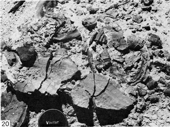
Few beds of the Smoky Hill lack skeletal remains of benthic macroinvertebrates, although such fossils are very scarce in some beds, especially in the upper third of the member. Certain thin stratigraphic intervals, however, are characterized by enormous abundance of such fossils. Along the outcrop of these intervals the eroded slopes are littered with whole and broken skeletal remains of inoceramids and oysters (Fig. 20), and where these zones crop out on gentle slopes acres of the land surface may be almost completely paved with shelly debris. Important shelly intervals, none more than about 1.5 m (4.9 ft) in maximum thickness, lie 4.5 m (14.8 ft), 22.3 m (73.1 ft), 25.8 m (84.6 ft), 85.5 m (280.4 ft), and 114 m (374 ft) above the Fort Hays-Smoky Hill contact. In the best exposures of shelly zones, articulated, in situ specimens of inoceramids abound.
Figure 20--Skeletal debris on eroded surface of shelly zone, Sec. 16, T. 14 S., R. 25 W., Trego County, Kansas. Lens cap is 6.0 cm (0.44 ft) in diameter.
Uintacrinus Limestone.
Near the middle of the Smoky Hill Member, apparently in the zone of Clioscaphites choteauensis Cobban, are sparse, widely scattered, thin to very thin lenses of hard, brittle, crinoidal limestone composed largely of articulated and disarticulated remains of the free-swimming crinoid Uintacrinus socialis. The rock has suffered greatly from compaction as evident in compressed skeletal remains and numerous microstylolites resulting from pressure solution. Occurrence and morphology of the crinoids are described in great detail by Springer (1901) and localities where the crinoids have been collected are summarized by Miller and others (1957). Despite many days of study in areas from which these crinoids have been collected, I have not been successful in locating any of the crinoidal lenses. Most of the readily accessible slabs containing crinoids were quarried during the nineteenth century and erosion since then has been insufficient to yield slabs of the quality once available in quantity.
Nodules.
Iron sulphide nodules, variously altered to iron oxide and commonly including jarosite, occur throughout the Smoky Hill Member. Most such nodules have oblate spheroidal shape and occur along bentonite seams or enclose, at least in part, large flattened valves of inoceramid bivalves. Many nodules contain a partially decomposed core of powdery to splintery marcasite, which may yet retain the original metallic luster.
These nodules range in size from a few millimeters to as much as 0.7 m (2.3 ft) in breadth by 12 cm (0.4 ft) in thickness and are a conspicuous feature in all but a few intervals within the member.
Additionally, small polycuboidal pyrite nodules as much as 7 cm (0.23 ft) in diameter are scattered through several meters of section in a few intervals of the Smoky Hill, and especially in parts of the section exposed at Localities 13, 19, and 20 (see Pl. 1). Whereas most such nodules are of equant dimensions, very roughly spherical in shape, and have no connection with bentonite seams, some of those at Locality 13 have a well-defined median plane, which represents a very thin bentonite seam along which the nodules formed. The latter have top and bottom halves, commonly bluntly cylindrical or conical, that are essentially mirror images.
Nodular, usually stratiform masses of chert occur within the Smoky Hill at several places, e.g., at Locality 24, at several places in Graham County (Prescott, 1955, p. 47), and at Norton (Logan, 1897a, p. 220). At Locality 24 the nodules reach thicknesses as great as 15 cm (0.5 ft). Smoky Hill chert is associated with highly weathered chalk and occurs in the uppermost part of the exposure. According to Frye and Leonard (1949, p. 30), silicification took place at the same time as silicification in adjacent Ogallala (Miocene and Pliocene) beds.
Register of Localities
During the course of this study I visited numerous Smoky Hill exposures in Trego, Gove, Logan, Ellis, Rooks, and Graham counties. Sections were measured only in the Smoky Hill River drainage basin and, from these, 12 sections were selected as a basis for the composite reference section (Pl. 1). Descriptions of these sections are included in the appendix and locality data are furnished below, in stratigraphically upward order.
Locality 1. Bluffs and badlands on west side of Hackberry Creek, in west half Sec. 24 and NW Sec. 25, T. 14 S., R. 25 W., Trego County, Kansas. Fort Hays Member (complete) and lower part of Smoky Hill Member.
Locality 17. Badlands and bluffs on west side of Hackberry Creek, in SW Sec. 16, T. 14 S., R. 25 W., Trego County, Kansas. Smoky Hill Member.
Locality 12. Highly eroded bluff on west side of small southern tributary to Smoky Hill River, in SW Sec. 16, T. 15 S., R. 26 W., Gove County, Kansas. Smoky Hill Member.
Locality 13. Highly eroded bluff and badlands on west side of small southern tributary to Smoky Hill River, in SE Sec. 29, T. 15 S., R. 26 W., Gove County, Kansas. Smoky Hill Member.
Locality 19. Badlands along small southern tributary to Hackberry Creek, in NE Sec. 2, T. 14 S., R. 26 W., Gove County, Kansas. Smoky Hill Member.
Locality 18. Bluff and adjacent erosional pinnacle directly south of Castle Rock, in SW Sec. 1, T. 14 S., R. 26 W., Gove County, Kansas. Smoky Hill Member.
Locality 22. Gully in small badlands in NW Sec. 18, T. 15 S., R. 31 W., Gove County, Kansas. Smoky Hill Member.
Locality 23. Bluffs along west side of small southern tributary to Smoky Hill River, in SW Sec. 7, T. 15 S., R. 31 W., Gove County, Kansas, and SE Sec. 12, T. 15 S., R. 32 W., Logan County, Kansas. Smoky Hill Member.
Locality 20. Highly eroded bluff on south side of Twin Butte Creek, in SW Sec. 16, T. 15 S., R. 34 W., Logan County, Kansas. Smoky Hill Member.
Locality 24. Bluff on east side of Ladder Creek, in SW Sec. 30, T. 15 S., R. 32 W., Logan County, Kansas. Smoky Hill Member.
Locality 25. Small butte situated northeast of bluff at Locality 24, in SE Sec. 30, T. 15 S., R. 32 W., Logan County, Kansas. Smoky Hill Member.
Locality 21. Badlands along small southern tributary to Ladder Creek, in NE Sec. 20, and NW Sec. 21, T. 15 S., R. 32 W., Logan County, Kansas. Upper part of Smoky Hill Member and lower part of Pierre Shale.
Marker Units
General Statement.
In the 1920s and 1930s geologists who were mapmaking in the Smoky Hill chalk country used bentonite seams as control points for determining surface structure (Virgil Cole, oral communication). In the only published work regarding utility of the bentonite sequence, Russell (1929) recognized 10 groups of seams, lettered A through J, but furnished few details of bentonite thickness, little on associated lithology, and nothing concerning fossils. Virgil Cole (oral communication, 1962) utilized 26 Smoky Hill markers, most of them bentonites, during the course of his work as an oil company geologist; in 1962 he communicated much of his knowledge to me during a brief trip through the Smoky Hill outcrop in Graham County.
My detailed study of the type Smoky Hill strata has served to identify numerous stratigraphic markers that can be used to determine with great precision position within the stratigraphic section. Some widely traceable bentonite seams are not included because they lack features necessary for positive identification. The described markers are those that can be recognized readily by persons not intimately acquainted with the area but whose sampling or fossil collecting requires accurate determination of stratigraphic position without measuring the entire member in detail. Knowledge of these markers is made especially necessary because at most localities less than 24 m (80 ft) of section, and usually less than 15 m (50 ft), are exposed. Furthermore, normal faulting has displaced the section in so many places that even exposures in closely spaced gullies or badlands tracts may belong to widely separated parts of the section.
In the Smoky Hill River section of the Niobrara Chalk, contact between the Fort Hays and Smoky Hill members lies at the top of a continuous sequence of massive, highly bioturbated chalky limestone beds. The uppermost of these limestone beds contains Inoceramus koeneni Muller and forms a prominent bench in bluffs overlooking Hackberry Creek at Locality 1. Above this bench the Niobrara section consists predominantly of thinly stratified chalk. In the following descriptions, thicknesses are given for marker units, intervals between marker units, and distance above the base of the composite Smoky Hill section. In general, thickness of a given marker unit and of the interval between two given markers is greater in the western part of the study area. However, in highly weathered sections markers and intervals between markers tend to be thinner than in little-weathered sections. From the base of the Smoky Hill Member to the base of Marker Unit 12, all thicknesses are based on exposures in western Trego and eastern Gove counties, whereas thicknesses from the base of Marker Unit 12 to the top of the composite section are based on exposures in western Gove and southern Logan counties. Details of individual marker units are presented in ascending order.
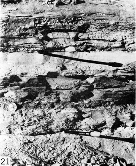
Marker Unit 1. Three bentonite seams in a 22 cm (0.72 ft) interval, separated by 5.2 cm (0.17 ft) and 12.8 cm (0.42 ft) beds of chalk (Fig. 21). Lowest bentonite 1.6 cm (0.05 ft), central bentonite 1.9 cm (0.06 ft), upper bentonite 0.6 cm (0.02 ft) thick (Fig. 21). A resistant bed of massive chalk 0.6 m (1 .9 ft) thick lies above this marker unit and forms a bench. A rich concentration of Inoceramus (Volviceramus) grandis characterizes a 1.1 m- (3.5 ft) thick interval, which lies approximately 2.6 m (8.5 ft) above Marker Unit 1. This marker lies 1.6 m (5.3 ft) above the base of the composite section.
Figure 21--Marker Unit 1, Sec. 25, T. 14 S., R. 25 W., Trego County, Kansas. Pencils mark top and bottom bentonite seams; coin (diam. 24 mm) marks central seam.
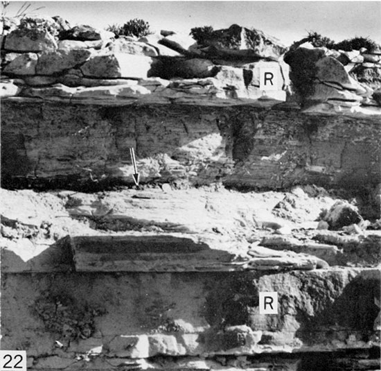
Marker Unit 2. A bentonite seam 2.5 cm (0.08 ft) thick, lying near the center of a 0.5 m- (1.6 ft) thick, nonresistant chalk interval, which is bounded above and below by lighter-colored chalk beds. The lower of these chalk beds is 19.8 cm (0.65 ft) thick and is bioturbated; the upper chalk bed is 21.4 cm (0.7 ft) thick and is laminated. In highly weathered exposures the lower chalk bed forms a resistant ledge, and the upper chalk bed forms a prominent bench (Fig. 22). A ferruginous gypsum seam 3 mm (0.01 ft) thick, probably a weathered bentonite, lies on the upper chalk bed and a bentonite seam 3 mm (0.01 ft) thick lies 0.55 m (1.8 ft) above this upper, resistant chalk bed. The marker bentonite lies 12.4 m (40.8 ft) above Marker Unit 1 and 14.3 m (46.8 ft) above the base of the Smoky Hill.
Figure 22--Marker Unit 2, Sec. 24, T. 14 S., R. 25 W., Trego County, Kansas. The bentonite seam (arrow) lies within a bed of nonresistant, laminated chalk. More massive, resistant beds of chalk adjacent to the laminated bed are indicated by letter R. Upper resistant chalk bed forms bench at top of exposure. Coin is 2.1 cm in diameter.
Marker Unit 3. Five subequally spaced beds of bioturbated chalk separated by beds of shaly chalk in an interval approximately 2.9 m (9.5 ft) thick. In little-weathered exposures the bioturbated chalk beds are lighter colored than adjacent laminated chalk beds and form minor shoulders on eroding slopes. In highly weathered exposures, the bioturbated chalk beds comprise a readily distinguishable bundle of resistant ledges, which hold up a small cliff and collectively form a major bench in large badlands areas (Fig. 16). The lowest bioturbated chalk bed is the thickest (0.49-0.55 m [1.6-1.8 ft]). The lower half of the marker unit is characterized by great abundance of inoceramid bivalve remains. A 0.6 m- (2.0 ft) thick interval rich in valves of Inoceramus (Volviceramus) grandis lies 2.9 m (9.6 ft) beneath the base of the marker. This marker unit lies 11.5 m (37.8 ft) above Marker Unit 2 and 25.8 m (84.7 ft) above the base of the Smoky Hill composite section.
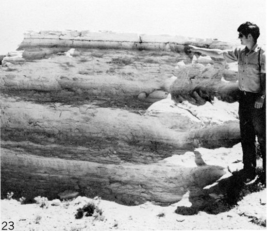
Marker Unit 4. A bentonite seam 3 mm (0.01 ft) thick overlain by a bioturbated chalk bed 9.2 to 12.2 cm (0.3-0.4 ft) thick. In little-weathered exposures, the bioturbated chalk bed forms a conspicuous, very light colored band on the outcrop, whereas in highly weathered exposures the chalk bed forms a minor, though conspicuous bench (Fig. 23). The marker lies 6.7 m (21.9 ft) above Marker Unit 3, and 35.4 m (116 ft) above the base of the composite section.
Figure 23--Marker Unit 4, Sec. 16, T. 14 S., R. 25 W., Trego County, Kansas. Cal James is pointing to bentonite seam that lies beneath bench-forming, bioturbated chalk bed.
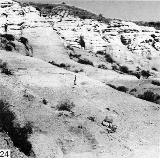
Marker Unit 5. A partly bioturbated, partly laminated chalk bed 27.5 to 30.5 cm (0.9-1.0 ft) thick overlain by a bentonite seam, which is 6 mm (0.02 ft) thick. The chalk bed is lighter colored than adjacent olive gray laminated chalk, breaks into coarse chips upon weathering, and forms a minor bench (Fig. 24). In partly weathered exposures, the marker chalk bed forms a conspicuous, light gray band on the outcrop. Above the bentonite seam approximately 7.6 cm (0.25 ft) of chalk is also lighter colored than adjacent chalk beds and forms part of the conspicuous band. This marker lies 2.8 m (9.1 ft) above Marker Unit 4, and 38.1 m (125.1 ft) above the base of the composite section.
Figure 24--Marker Unit 5, Sec. 16, T. 15 S., R. 26 W., Gove County, Kansas. Hat is 14 cm tall. Note prominent light-colored band, formed by outcrop of marker, which extends across exposure.
Marker Unit 6. A bentonite seam 0.9 to 1.2 cm (0.03-0.04 ft) thick, which lies in the midst of a thick section of more or less laminated chalk. This marker lies shortly above the uppermost occurrences of Inoceramus (Volviceramus) grandis, and within the lower part of the range of Inoceramus (Cladoceramus) undulatoplicatus Roemer, which is readily recognizable because of the coarse radiating folds in its huge, snowshoe-like valves. The bentonite lies approximately 1.2 m (4.0 ft) above the first stratigraphic occurrence of pebble-sized polycuboidal pyrite nodules, which are common also through several meters of section directly above the marker. This marker unit lies 16.4 m (53.8 ft) above Marker Unit 5 and 54.9 m (180 ft) above the base of the composite section.
Marker Unit 7. A medium greenish gray (5GY5/1) to olive gray (5Y4/1) bentonite seam, which is 1.2 to 1.5 cm (0.04-0.05 ft) thick. Color and relatively large thickness are unusual for a bentonite in this part of the section. This bentonite seam can be identified positively by the presence 1.2 to 1.4 m (4.1-4.5 ft) lower in the section of two very thin bentonite seams, which are separated by 12 to 14 cm (0.4-0.45 ft) of laminated chalk. The lower of these two bentonite seams is 3 to 6 mm (0.01-0.02 ft) thick; the upper is 3 mm (0.01 ft) or less in thickness and consists of a persistent ferruginous seam that probably represents a highly altered bentonite. The two very thin bentonite seams lie directly above the uppermost known occurrence of Inoceramus (Cladoceramus) undulatoplicatus. A 0.6 cm- (0.02 ft) thick seam of bentonite lies 2.8 m (9.2 ft) above Marker Unit 7 and is separated from the latter by sparsely fossiliferous, laminated chalk. This marker lies 8.6 m (28.1 ft) above Marker Unit 6, and 63.4 m (208 ft) above the base of the composite section.
Marker Unit 8. A pale grayish orange pink (5YR8/2) to pinkish gray (5YR8/1) bentonite seam 0.6 to 1.2 cm (0.02-0.04 ft) thick. Another bentonite seam 3 mm (0.01 ft) thick lies an average of 2 m (6.5 ft) below the marker, and a bentonite seam 0.9 cm (0.03 ft) thick lies 1.9 m (6.1 ft) above the marker. Specimens of Clioscaphites vermiformis (Meek and Hayden) occur in a 0.76 m- (2.5 ft) thick interval the top of which lies approximately 1.5 m (4.9 ft) beneath the marker. The marker bentonite lies 17.1 m (56.2 ft) above Marker Unit 7, and 80.5 m (264 ft) above the base of the composite section.
Marker Unit 9. Two bentonite seams separated by 0.71 to 1.0 m (2.35-3.28 ft) of poorly laminated chalk, in the middle of which lies a bioturbated chalk bed 9.2 cm (0.3 ft) thick (Fig. 15). In little- or partly weathered sections the bioturbated chalk bed forms a prominent white band on the outcrop (Fig. 15), and in much-weathered exposures forms a projecting ledge in cliff faces. The lower bentonite seam is 0.9 to 1.2 cm (0.03- 0.04 ft) thick; the upper bentonite seam is 0.3 to 1.2 cm (0.01-0.04 ft) thick. The marker unit embraces the lower part of the ranges of Clioscaphites choteauensis and Inoceramus balticus, and is conspicuous for abundance of Pseudoperna congesta and I. (Platyceramus) platinus, which are also abundant in the first foot (1/3 m) of chalk above the marker unit. This marker lies 5.2 m (17 ft) above Marker Unit 8, and 85.8 m (281.4 ft) above the base of the composite section.
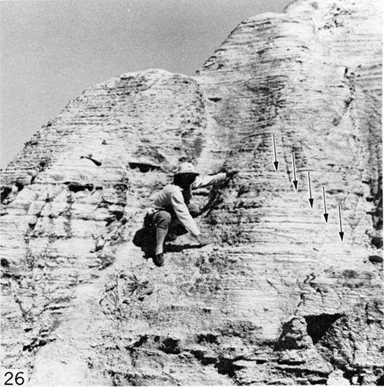
Marker Unit 10. Approximately 6.7 m (22 ft) of tough, poorly stratified, partly bioturbated, somewhat granular-looking chalk, which in little-weathered exposure forms a smooth, buttressed slope that is lighter colored than adjacent chalk beds (Fig. 17). In highly weathered exposures this unit forms very pale orange (10YR8/2) to grayish orange (10YR7/4) lichen-splotched, cavernously weathered cap rocks on erosional remnants of the chalk. This unit is the main caprock-forming unit of the Smoky Hill Member and caps such well-known features as Castle Rock (Fig. 3), Monument Rocks (Fig. 25), the Sphynx and Cobra Rock in Gove County, and Chalk Bluff (Fig. 4) in Logan County. This marker is overlain directly by the distinctive bentonite cluster in Marker Unit 11 and is underlain by a sequence of five very thin, subequally spaced bentonite seams in a 0.8 m (2.7 ft) thickness of tough, poorly laminated chalk (Fig. 26). The thick caprock-forming marker unit contains the upper part of the range of the Clioscaphites choteauensis Range Zone. This marker unit lies 1.94 m (6.4 ft) above Marker Unit 9, and 88.5 m (290.3 ft) above the base of the composite section.
Figure 25--Erosional pinnacles in Smoky Hill at Monument Rocks, Sec. 34, T. 14 S., R. 31 W., Gove County, Kansas. Caprock is partially bioturbated, resistant chalk of Marker Unit 10.
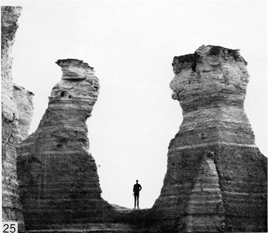
Figure 26--Group of five bentonite seams (arrows), which underlie buttress- and (above) caprock-forming chalk of Marker Unit 10, Sec. 1, T. 14 S., R. 26 W., Gove County, Kansas. Allen Archer's hands are on lowermost and uppermost scams.
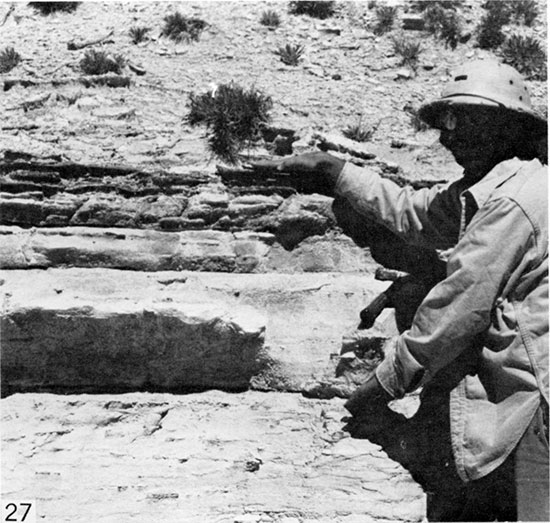
Marker Unit 11. Four bentonite seams in a 0.55 to 0.76 m (1.8-2.5 ft) thickness, separated by beds of tough, bioturbated chalk (Fig. 27). The thin, basal bentonite seam is 3 to 6 mm (0.01-0.02 ft) thick and is overlain by 0.29 to 0.43 m (0.95-1.4 ft) of massive chalk, which forms a minor ledge in some exposures. The second and third bentonite seams are also very thin (6-12 mm [0.02-0.04 ft]). The uppermost bentonite seam is locally as much as 2.7 cm (0.09 ft) thick, but together with associated iron oxide and gypsum the seam reaches 7.6 cm (0.25 ft) locally. The second, third, and fourth bentonite seams are separated by 9.1 to 12.2 cm- (0.3-0.4 ft) thick beds of tough, massive, bioturbated chalk. Marker Unit 11 is readily recognizable not only by the distinctive bentonite sequence but also by association with the main caprock-forming unit. The marker lies directly on Marker Unit 10, and 95.7 m (312.3 ft) above the base of the composite section.
Figure 27--Group of four bentonite seams and intervening chalk beds that comprise Marker Unit 11, Sec. 1, T. 14 S., R. 26 W., Gove County, Kansas. Allen Archer's hands are on lowermost and uppermost seams.
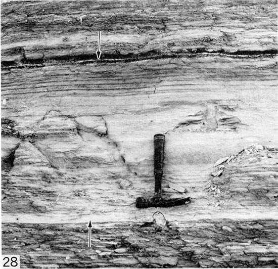
Marker Unit 12. A pair of bentonite seams separated by 6.7 to 15.3 cm (0.22-0.5 ft) of laminated chalk, all in a total thickness of 8.8 to 22.5 cm (0.29-0.74 ft) (Fig. 13). The lower bentonite is the more prominent, and is 2.1 to 3.3 cm (0.07-0.11 ft) thick, but together with associated ferruginous and gypsiferous matter the seam may reach a total thickness of 6.7 cm (0.22 ft). The upper seam is merely a moderate reddish brown (10R4/6) to light brown (5YR5/6) ferruginous streak, probably a weathered bentonite, which is a maximum of 6 mm (0.02 ft) thick but in places is only a fraction of that thickness. This marker is not distinguished by associated fossils or adjacent bentonite seams, but a 0.27 to 0.43 m- (0.9-1.4 ft) thick bed of medium to dark yellowish brown (10YR5/2, 10YR4/2) laminated chalk lies shortly above the midpoint between Marker Unit 11 and Marker Unit 12. The latter lies 5.4 m (17.8 ft) above Marker Unit 11, and 101.2 m (331. 9 ft) above the base of the composite section.
Marker Unit 13. Two seams of bentonite(?) and ferruginous and gypsiferous material, separated by 3.7 cm (0.12 ft) of laminated chalk. The lower seam is 1.8 cm (0.06 ft) thick and is composed mostly of iron oxide and gypsum. The upper seam is 1.2 cm (0.04 ft) thick and is also composed mostly of iron oxide and gypsum. Laminated chalk lying both below and above the marker, through a thickness of several meters, contains numerous distinctive specimens of Inoceramus (Platyceramus) platinus, which are usually less than 31 cm (1.0 ft) in maximum dimension and show particularly well the quadrate form of the shell. Peripheral portions of the valves, which are much thicker than the central portions, are abundant on eroding slopes adjacent to the marker unit. A very thin bentonite seam lies 2.3 m (7.4 ft) above the marker. Marker Unit 13 lies 10.3 m (33.9 ft) above Marker Unit 12 and 111.7 m (336.4 ft) above the base of the com posite section.
Marker Unit 14. Two very thin seams of bentonite and a conspicuous bed of organic-rich chalk, which is darker colored than the adjacent laminated chalk beds, all in a 0.8 m- (2.6 ft) thick interval. The two bentonite seams are very thin (less than 3 mm [0.01 ft]), both seams consisting mostly of iron oxide and gypsum. Together with associated secondary mineral matter the lower seam is 0.6 to 1.5 cm (0.02-0.05 ft) thick and the upper ranges from less than 3 mm to 6 mm (0.01-0.02 ft) in thickness. The bentonite seams are separated by 18.3 to 21.3 cm (0.6-0.7 ft) of obscurely laminated chalk. The associated brown, organic-rich chalk lies 0.3 to 0.41 m (1.0-1.35 ft) above the upper bentonite seam. This darker-colored chalk bed forms a conspicuous dark band on eroded slopes (Fig. 14). In little-weathered exposures the marker unit is identified further by the presence 0.41 m (1.4 ft) above the organic-rich chalk bed of a prominent bed of tough, granular chalk 0.49 m (1.6 ft) thick, which is conspicuously lighter in color than the directly adjacent chalk. The dark-colored and light-colored beds together are visible from a considerable distance and can be traced readily across the outcrop (Fig. 14). Marker Unit 14 lies 6 m (19.5 ft) above Marker Unit 13, and 117.7 m (386.1 ft) above the base of the composite section.
Marker Unit 15. A 3.0 to 4.6 cm- (0.1-0.15 ft) thick bed of tough, granular chalk and a very thin, very light colored bentonite seam, separated by a 0.49 to 0.52 m(1.6-1.7 ft) interval of both well-laminated, darker-colored chalk and granular, lighter-colored chalk (Fig. 28). The lower marker chalk bed forms a conspicuous, thin, nearly white band on little-weathered exposures. The bentonite seam is approximately 0.9 cm (0.03 ft) thick, white to very pale orange (10YR8/2), and is hard and brittle locally. Together with bounding crusts of associated iron oxide and gypsum the seam is locally as much as 5.5 cm (0.18 ft) thick. The intervening laminated chalk is darker-colored at the top and bottom, and lighter-colored, tough, and granular in the middle. A pair of very thin bentonite seams, separated by 12.3 to 15.3 cm (0.4- 0.5 ft) of chalk, lies 1.6 to 1.8 m (5.3-6.0 ft) above the marker unit and aids in identification of the marker. Chalky strata lying adjacent to the marker contain few macroinvertebrate fossils. Marker Unit 15 lies 13.7 m (45 ft) above Marker Unit 14, and 132.2 m (433.7 ft) above the top of the composite section.
Figure 28--Marker Unit 15, Sec. 16, T. 15 S., R. 34 W., Logan County, Kansas, comprising light-colored band of granular chalk (lower arrow) and a bentonite seam (upper arrow), separated by interval of laminated and nonlaminated chalk. Hammer is 28 cm long.
Marker Unit 16. Two bentonite seams and a ferruginous seam in an interval that is 0.27 to 0.37 m (0.9-1.2 ft) thick and lies near the top of a thick chalk interval that is conspicuously light- and dark-banded (Fig. 12). The lowest bentonite seam is as much as 1.8 cm (0.06 ft) thick and is separated from the second bentonite seam by 6.1 to 7.6 cm (0.2-0.25 ft) of chalk. The second bentonite seam is 0.6 to 1.5 cm (0.02-0.05 ft) thick, consists largely of ferruginous and gypsiferous material, and is overlain by 18.3 to 24.4 cm (0.6-0.8 ft) of chalk. The top of this marker is a ferruginous seam, probably a highly weathered, very thin bentonite seam, which is 0.3 to 0.9 cm (0.01-0.03 ft) thick. Identification of this marker is aided by association with conspicuously light- and dark-banded chalk and by the presence of two additional bentonite seams, separated by 0.29 to 0.34 m (0.95-1.1 ft) of chalk, the upper of which is the thicker and lies 1.4 to 1.6 m (4.6-5.4 ft) below the marker unit. This part of the section contains very few macroinvertebrate fossils. The marker unit lies 11.9 m (39.1 ft) above Marker Unit 15, and 145 m (474.5 ft) above the base of the composite section.
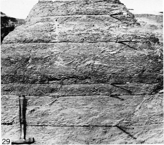
Marker Unit 17. Five very thin seams of bentonite in an interval of mostly crinkly bedded chalk 0.37 to 0.61 m (1.2-2.0 ft) thick. The bentonite seams are subequally spaced through the interval, with the second and third seams being closest together. The seams may be associated with ferruginous and/or gypsiferous material, and locally contain no discernable flakes of bentonite. In eroding badlands the five bentonite seams form a group of distinctive reentrants that can be traced as a group across the outcrop (Fig. 29). Two prominent bentonite seams lying 0.4 to 0.49 m (1.3-1.6 ft) apart, and separated by a chalk interval that contains a very thin seam of bentonite in its upper half, lie shortly higher in the section, and aid in identification of the marker unit. The lower of these two bentonite seams lies 0.78 to 1.1 m (2.5-3.7 ft) above the marker unit and is thinner than the upper bentonite, which is 3.0 to 4.6 cm (0.1-0.15 ft) thick. The marker unit lies at the base of a 3 m- (10 ft) thick interval that contains at least 13 bentonite seams. Marker Unit 17 lies 2.6 to 3.0 m (8.6-9.8 ft) above Marker Unit 16, and 147.6 m (484 ft) above the base of the composite section.
Figure 29--Marker Unit 17, Sec. 27, T. 13 S., R. 35 W., Logan County, Kansas. Knife (bottom) and four pencils mark the five bentonite seams.
Marker Unit 18. Two relatively thick and prominent bentonite seams, separated by 0.34 to 0.49 m (1.1-1.6 ft) of obscurely laminated to laminated chalk, which forms a minor resistant ledge in highly weathered exposures (Fig. 18). The lower bentonite seam is 3.3 to 6.1 cm (0.11-0.2 ft) thick; the upper seam is 7.0 to 11.6 cm (0.23-0.38 ft) thick. These are among the thickest bentonite. seams in the entire Smoky Hill Member, and the only two of such large thickness that are so close together stratigraphically. A bentonite seam 1. 5 to 2.4 cm (0.05-0.08 ft) thick lies 0.98 to 1.2 m (3.2-3.9 ft) below the marker unit, and a pair of very thin bentonite seams, separated by 5.5 cm (0.18 ft) of chalk, lie 0.39 to 0.7 m (1.3-2.3 ft) above the marker. The upper of these two bentonites is the thicker; in places the lower seam is represented only by a seam of iron oxide. Marker Unit 18 lies 4.5 to 5.4 m (14.6-17.8 ft) above Marker Unit 17, and 152.4 m (499.8 ft) above the base of the composite section.
Marker Unit 19. Five very thin bentonite seams in an interval 1. 0 to 1.1 m (3.2-3.6 ft) thick and separated by beds of rather massive chalk. The lowest two seams are a maximum of 6 mm (0.02 ft) thick and are separated by 2.1 cm (0.07 ft) of chalk. This pair of bentonites lies 0.73 to 0.82 m (2.4-2.7 ft) below the third bentonite seam, which is also 6 mm (0.02 ft) or less in thickness. The fourth bentonite is 3 to 6 mm (0.01-0.02 ft) thick and is separated from the third bentonite seam by 18.3 to 19.8 cm (0.6-0.65 ft) of chalk. The uppermost of the five bentonite seams is 0.9 cm (0.03 ft) thick and is separated from the fourth seam by 3.6 cm (0.12 ft) of chalk. The distinctive pairing of the lowest two and upper two seams in such a small stratigraphic interval is unique in the Smoky Hill Member and serves, together with the central bentonite seam, to identify the marker unit. Poor stratification of associated chalk beds and paucity in them of macro invertebrate fossils are further characteristics of the marker. This marker unit lies 5.6 m (18.5 ft) above Marker Unit 18, and 158.7 m (520.5 ft) above the base of the composite section.
Marker Unit 20. Four seams of bentonite in a 0.82 m (2.7 ft) interval, separated by beds of tough, ledge-forming chalk or chalky limestone (Fig. 30). The lowest two seams are 0.6 and 1.5 cm (0.02 and 0.06 ft) thick, respectively, and are separated by 1.5 cm (0.06 ft) of chalk. The third bentonite is 9 mm (0.03 ft) thick and is separated from the second bentonite by 0.52 cm (1.7 ft) of chalk, which contains a 3 mm (0.01 ft) seam of powdery gypsum 9.1 cm (0.3 ft) above its base. This thicker chalk bed has been quarried locally for building stone (see Merriam, 1963, pl. 3C). In highly weathered sections the powdery gypsum seam appears only as a small reentrant on the chalk face. The fourth bentonite seam is 9 mm (0.03 ft) thick and is separated from the third seam by 24.3 cm (0.79 ft) of chalk. The pairing of the two lowest bentonites, the distinctive spacing of all four seams, and the resistant character of associated chalk or chalky limestone beds is unique in the Smoky Hill Member. This interval contains few macroinvertebrate fossils. Marker Unit 20 lies 2.1 m (7.0 ft) above Marker Unit 19, and 161.9 m (531.1 ft) above the base of the composite section.
Figure 30--Marker Unit 20, Sec. 20, T. 15 S., R. 32 W., Logan County, Kansas. The pair of very thin bentonite seams at base of marker interval is beneath the lowest overhanging ledge, just below Cal James' hand. The third and fourth bentonite seams are indicated by arrows. A powdery gypsum seam lies just above Cal's hand, and forms a prominent reentrant.
Marker Unit 21. A 2.2 m- (7.3 ft) thick bed of tough, granular chalk or chalky limestone that is only crudely stratified and tends to form a smooth, buttress-like slope where partly weathered, and is a distinctive moderate reddish orange (10R6/6) color where highly weathered. The uppermost part of this interval is a major bench former in badlands. From a distance the unit appears thinly stratified, but the rock is not well laminated. The upper part of this unit contains molds of a very large, smooth species of Baculites and large specimens of Inoceramus balticus Bohm. A similar unit, 2.0 m (6.7 ft) in thickness, overlies the marker bed but from a distance appears distinctly laminated and the rock weathers shaly in part. The marker unit lies directly on a 9 mm- (0.03 ft) thick seam of ferruginous and gypsiferous bentonite. A similar seam, 2.7 cm (0.09 ft) in thickness, lies 2.0 m (6.7 ft) above the marker. Marker Unit 21 lies 2.7 m (9.0 ft) above Marker Unit 20, and 165.5 m (542.8 ft) above the base of the composite section.
Marker Unit 22. A medium dark gray (N4) bentonite bed 11.6 cm (0.38 ft) thick and lying in the midst of a soft-weathering chalk interval that is characterized by abundance of beds with crinkly structure. A very thin bentonite seam lies 0.64 m (2.1 ft) below the marker and another bentonite seam 2.4 cm (0.08 ft) thick lies 0.4 m (1.3 ft) above the marker. This marker lies 6.25 m (20.5 ft) below the Smoky Hill-Pierre contact, and Smoky Hill strata above the marker are characterized by no less than 11 additional bentonite seams, which are spaced at intervals ranging from 0.2 to 0.76 m (0.65-2.5 ft). The marker is the only relatively thick bentonite seam in the upper 7.6 m (25 ft) of the Smoky Hill. Marker Unit 22 lies 6.4 m (21 ft) above Marker Unit 21, and 174.1 m (571.1 ft) above the base of the composite section.
Marker Unit 23. A bentonite seam 4.9 cm (0.16 ft) thick that lies 24.4 cm (0.8 ft) below the Niobrara-Pierre contact (Fig. 7). Beginning approximately 3.9 m (10.0 ft) below the top of the Smoky Hill, the member grades stratigraphically upward from predominantly flaky-weathering, crinkly chalk through chalky shale into calcareous shale that contains a few thin intervals of noncalcareous shale. The marker unit can be identified by association with this less calcareous part of the member and by proximity to the Pierre Shale. The Smoky Hill-Pierre contact lies at the top of the calcareous sequence, overlying Pierre strata consisting of olive black to dark olive gray (5Y2/1, 5Y3/1), silty, flaky-weathering, noncalcareous shale. A very thin, nearly white seam of bentonite, 6 mm (0.02 ft) thick, lies 0.32 m (1.05 ft) above the base of the Pierre Shale and makes a conspicuous white band on eroded slopes. Marker Unit 23 lies 7.2 m (23.7 ft) above Marker Unit 22, and 181.5 m (595.2 ft) above the base of the composite section. Total thickness of the composite section is 181.8 m (596.3 ft).
Physical Correlation
Detailed published information for the entire Smoky Hill is available for only one other complete stratigraphic section, that of Scott and Cobban (1964) for exposures along the Arkansas River valley at and shortly west of Pueblo, Colorado. The Pueblo section contains numerous bentonite seams and very thin ferruginous seams (probably weathered, very thin bentonites) not recorded by Scott and Cobban, so the reported bentonite sequence cannot at this time be matched precisely with that of the Kansas Smoky Hill. However, my own examination of the Pueblo section confirms direct correlation of several composite-section marker units, as follows:
- The lower part of the lower limestone unit, including beds 1 through 9 of Scott and Cobban (1964, p. 13) are equivalent to Marker Unit 3 of Kansas.
- Beds 21 and 22 of the lower limestone unit (Scott and Cobban, 1964, p. 13) are equivalent to Marker Unit 4 of Kansas.
- Beds 1 and 2 of the middle chalk unit (Scott and Cobban, 1964, p. 17) are equivalent to at least the upper half of Marker Unit 10 of Kansas.
- Beds 3 through 6 of the middle chalk unit (Scott and Cobban, 1964, p. 17) are equivalent to most of Marker Unit 11 of Kansas.
- Beds 47, 48, and 49 of the upper chalky shale unit (Scott and Cobban, 1964, p. 20) are equivalent to Marker Unit 18 of Kansas.
- The upper chalk unit (Scott and Cobban, 1964, p. 21) is equivalent to Marker Unit 21 of Kansas.
- At Pueblo, Colorado, the basal part of the Pierre Shale comprises calcareous shale through which are scattered several seams of bentonite. Called "unnamed transition member" of the Pierre by Scott and Cobban (1964, p. 23), these strata are equivalent to Smoky Hill strata lying above Marker Unit 21 of Kansas. A seam of bentonite 12.2 cm (0.4 ft) thick, and lying 5.9 m (19.2 ft) above the base of the transition member, is equivalent to Marker Unit 22 of Kansas.
In addition to the above, beds 11 through 20 of the lower shale unit (Scott and Cobban, 1964, p. 11) include two closely spaced limonite seams and two bentonite seams, which represent Marker Unit 2 of Kansas.
Collectively these physical correlations of the Kansas and Pueblo sections furnish a chronological framework that reinforces correlations based on macroinvertebrate fossil zones. Further study of the thick middle shale unit of Scott and Cobban (1964, p. 13) should serve to identify additional markers in the interval that correlates with that part of the Kansas section containing Marker Units 5 through 9.
Prev Page--Nomenclature || Next Page--Biostratigraphy
Kansas Geological Survey, Geology
Placed on web Feb. 20, 2015; originally published Dec. 1982.
Comments to webadmin@kgs.ku.edu
The URL for this page is http://www.kgs.ku.edu/Publications/Bulletins/225/04_strat.html