![]()
Prev Page--Depositional Environments || Next Page--Conclusions
Mechanisms of Kiowa Transgression Implied by Longford Member
The abundance of thick, lenticular deposits of Kiowa sandstone in facies-equivalent parts of the Kiowa Formation in Ottawa, Saline, and McPherson counties, and elsewhere in central Kansas (Franks, 1966, 1975; Bayne and others, 1971; Scott, 1970b), indicates that Longford sediments were deposited along a lagoonal or embayed barrier coast as the Kiowa sea flooded over the gentle topography developed on Permian bedrock along the gently dipping western flank of the Nemaha anticline (Fig. 1). In many places, typical Kiowa shale overlies the inferred lagoon or bay deposits, which in turn overlie the inner shore deposits represented by the siltstone that marks the top of the Longford Member (Pl. 2, Fig. 15). Elsewhere, thick, lenticular deposits of Kiowa sandstone overlie the lagoon or bay deposits and the inner shore siltstone (e.g., in parts of southwestern Clay County, northwestern Dickinson County, and northeastern Saline County). Even though it has not been studied in detail, the apparently scattered distribution of Kiowa shale and sandstone above the fluvial to inner shore sequences of Longford Member, combined with the absence of obvious transgressive disconformities, offers insight into the mechanisms by which the Kiowa shoreline shifted landward as the sea invaded north-central Kansas (Fig. 16).
Papers by Fischer (1961), Schwartz (1967), and Swift (1968) include descriptions of more-or-less classical concepts of transgressive stratigraphy whereby shoreface erosion, combined with washover of sand from barrier islands and growth of tidal deltas into lagoons, drives barrier bars landward (Fig. 16-A). As noted by Swift (1968), shoreface erosion or ravinement can be complemented by erosion induced by migration of tidal inlets as barrier islands are extended by longshore movement of sediment. Ravinement leads to partial to complete destruction of lagoon or bay deposits as barrier islands migrate over them. Figure 16-A shows only partial destruction of the lagoonal record. One or more transgressive disconformities are introduced into the transgressive sedimentary record. Tidal-inlet sands or open-sea sands reworked from the barrier system commonly form a transgressive sheet sand that disconformably overlies the eroded remnants of lagoon or bay deposits, or whatever remains of the land surface on which the lagoon or bay sediments accumulated. The scheme does not match the sequences of Longford beds preserved in north-central Kansas.
Figure 16--Models of transgressive records along barrier coasts. A) Transgression and shoreface erosion, commonly complemented by erosion induced by migration of tidal inlets, resulting in partial destruction of lagoon sediments. Erosion results in transgressive disconformities; nearshore deposition may lead to development of transgressive sheet sands (after Fischer, 1961, and Swift, 1968). B) Transgression and shoreface erosion, perhaps accompanied by erosion induced by migration of tidal inlets, resulting in destruction of barrier-bar and lagoon records, but modified by progradation of barrier-island, lagoon, and fluvial sediments (after Ryer, 1977). C) Transgression accompanied by in-place growth and eventual submergence of barrier islands, leading to stepwise, landward shift of barrier-island shores and preservation of fluvial, estuarine, and lagoon or bay records. Model C applies to Longford records developed in valleys in Permian bedrock.
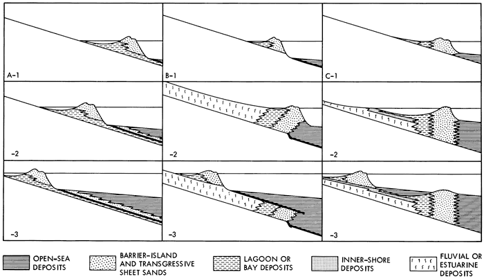
Ryer (1977) developed a skillful modification of the transgressive model outlined above in order to account for the distribution of open-sea, barrier-island, lagoon, and fluvial sediments in strata that were deposited along the western margins of the Late Cretaceous sea of the Western Interior (Fig. 16-B). Ryer noted the diverse balances that can obtain between rates of transgression and rates of supply of sediment to barrier shorelines, and the importance of progradational periods during times of overall transgression. As above, transgression leads to ravinement and to development of transgressive disconformities that separate open-sea deposits from whatever materials the sea transgressed. Deep erosion on the shoreface and in migrating tidal inlets can eliminate all record of lagoon or bay deposits. Periods of progradation, however, lead to outbuilding of barrier-island, lagoon, and fluvial deposits (Fig. 16-B-2), which become truncated in turn by the next transgressive pulse as the supply of sediment is reduced (Fig. 16-B-3). Instead of a continuous transgressive sheet sand being deposited, discontinuous bodies of barrier-island sand are preserved. Depending on the degree of detail with which field work is carried out, the discontinuous, progradational barrier sands could be mistaken for a single, transgressive sheet sand. Moreover, careful synthesis of field data should reveal that fluvial and lagoon deposits overlie the barrier sands, which in turn overlie open-sea sediments.
The apparent completeness of the Longford record in many places and the widespread occurrence of inferred lagoon or bay deposits above the capping Longford siltstone accord with a model of in-place growth, eventual submergence, and step-wise, landward shifting of barrier islands during transgression (Fig. 16-C). Sanders and Kumar (1975) cited evidence for in-place drowning and landward shift of barrier systems along the Atlantic coast of Long Island, New York, and a similar mode of transgression accounts for the distribution of Late Cretaceous swamp, barrier-island, and open-sea deposits in the San Juan basin of New Mexico (Hollenshead and Pritchard, 1961). The process readily accounts for the apparently scattered distribution of open-sea deposits of Kiowa shale and thick, lenticular deposits of Kiowa barrier sandstone above the inner shore deposits of siltstone that cap the Longford Member. It also is consistent with the thick, lenticular deposits of Kiowa sandstone in facies-equivalent parts of the Kiowa Formation, and with the relatively thick accumulations of silty shale and brownish--gray clay rocks and shale that were noted near the western limits of Longford exposures. The silty shale and brownish-gray clay rocks and shale may well represent lagoon or bay sediments that were deposited behind barrier systems while Longford fluvial and estuarine sediments were deposited in broad valleys to the east and northeast (Fig. 16-C-2).
A sufficient supply of sand must have been provided to the barrier system to counterbalance the rise in sea level and to permit upward growth of the barriers (Swift, 1968; Sanders and Kumar, 1975). The abundant, southward dipping cross-strata in thick, lenticular deposits of Kiowa sandstone accord with longshore transport of the sand (Fig. 1) (Franks, 1966, 1975; Bayne and others, 1971), and with upward growth of the barriers (Fig. 16-C-2). Closer to the barrier system, relatively thick sequences of estuarine and lagoon sediments probably formed. As sea level rose, the locus of fluvial and estuarine sedimentation shifted up valley, and inner shore deposits represented by the siltstone at the top of the Longford Member migrated landward. Eventually, the supply of san to Kiowa barrier islands became modified, perhaps in response to the increasing width of the lagoon or bay systems, so that upward growth of the barriers could not continue. The barriers became drowned and new barrier systems were generated close to the inner shores of former bays and lagoons as surf zones shifted landward (Fig. 16-C-3). The stepwise, landward shift of the barrier systems resulted in widespread formation of open-sea deposits of Kiowa shale over lagoon or bay deposits that overlie the innershore siltstone, and in more localized deposition of barrier sands above lagoon and inner-shore sediments.
The thickest and most complete Longford records formed along the deeper valleys eroded into Permian bedrock on the gentle western flank of the Nemaha anticline (Fig. 1). One such valley must have been located in southwestern Clay County near type Longford. Figure 16-C can be construed as representing the sedimentary framework along, such a deep valley. Elsewhere, inner shore silts were deposited directly on drainage divides as sea level rose, as in parts of northwestern Marion County (Fig. 1). The situation is analogous to the preservation of Holocene fluvial, marsh-fringe, salt-marsh, lagoonal-shore, and lagoon sediments beneath barrier-island sands in drowned valleys developed on Pleistocene coastal sediments along the Delaware coast (Kraft, 1971, p. 2152-2153). There, as in Kansas, pre-transgression topography exerted a profound control on the preservation of fluvial to lagoon sediments. The pre-transgression topography developed on Permian bedrock may also have influenced patterns of longshore transport of sand, and ultimately may have been responsible for the landward shift of barrier islands, many of which may have developed originally as spits.
Provenance of Longford Sediments and Clay-mineral Distributions
Heavy minerals noted in thin sections of Longford sandstone (zircon, tourmaline, staurolite) suggest that the heavy-mineral suite in Longford rocks does not differ appreciably from the heavy-mineral suites in other Kiowa sandstone (Franks, 1966, 1975). The heavy minerals accord with derivation of much of the sand by reworking of Paleozoic sedimentary rocks in the continental interior to the east and northeast of Kansas. The staurolite, however, indicates that some of the sand may have been derived from the crystalline terrains of the central Appalachian Mountains, either directly, or by reworking of Upper Permian or Mesozoic sedimentary rocks now eroded from the continental interior (Franks, 1966, 1975).
Much of the silt in the Longford Member probably was derived from nearby Paleozoic source rocks, chiefly silty Permian or Pennsylvanian bedrock. The scarce, sand-sized quartz grains set in a matrix of silt-sized quartz in much Longford siltstone (Fig. 6) impart a texture that is suggestive of much siltstone that Swineford (1955) described from the Upper and Middle Permian of southern Kansas (cf. Swineford's Plate 19-D, p. 128). The sand-sized grains in both the Longford siltstone and the Permian rocks are rounded and show nearly straight extinction. Most of the siltstone in the upper parts of the Longford Member probably formed by reworking and washing of Longford sediments close to or along the inner shores of estuaries, bays, and lagoons, but the ultimate source for much of the silt doubtless included nearby Pennsylvanian and Permian rocks. The heavy minerals (chiefly zircon and tourmaline) noted in thin sections of the siltstone are compatible with heavy minerals in Pennsylvanian and Permian rocks (Potter and Pryor, 1961; Swineford, 1955). The absence or near absence of feldspar, which is present in Permian siltstone, can be attributed to weathering of Permian rocks prior to reworking.
The abundant kaolinite and smectite in Longford clay rocks (Pl. 2), together with the small amounts of chlorite or vermiculite detected in many of them (Fig. 8), points to derivation of much of the clay from soils that formed on dominantly illitic and chloritic or vermiculitic Paleozoic bedrock before the Kiowa sea invaded central Kansas. X-ray diffraction studies of Longford clays, including samples from a number of scattered exposures and three measured sections not shown in Plate 2, indicate that the proportions of kaolinite and smectite do not vary systematically with the kinds of Longford clay rocks. Soil-forming processes that affected Longford flood-plain sediments were not responsible for consistent changes in mineralogy in the detrital clays, and weathering of the alluvial soils was inadequate to bring about complete destruction of 2:1 clay minerals (Pl. 2).
An irregular upward increase in the proportions of kaolinite to smectite and other clay minerals is apparent in the Longford Member (Pl. 2). The upward change may be related as much to the upward increase in the abundance of siltstone in the member as it is to variations brought on either by penecontemporaneous soil-forming processes or by differences in the detrital clay assemblages supplied to Longford depositional realms. The abundance of kaolinite in silty Longford rocks or in clay rocks intercalated with more permeable silty beds could reflect post-depositional, intra-stratal alteration or recent weathering of smectite to kaolinite (Glass, 1958; Glass and others, 1956; Potter and Glass, 1958; Wilson and Pittman, 1977). Alternatively, the relative abundance of kaolinite associated with siltstone might stem from sorting brought on by differential transport and sedimentation of differently sized kaolinite and smectite settling aggregates (Edzwald and O'Melia, 1975). Evidence discussed in the following paragraphs, however, suggests that differential transport and sedimentation may not have been an important factor in the development of Longford clay-mineral assemblages.
Relatively consistent variations in clay-mineral assemblages are found among Longford rocks, Kiowa lagoon or bay deposits above the capping Longford siltstone, and typical, open-sea Kiowa shale. Illite and "degraded illite" are scarce components in Longford clay rocks (Pl. 2), but they are major components in most Kiowa shale (Franks, 1966). The proportions of kaolinite and smectite in Kiowa shale range widely, but kaolinite generally is most abundant near the top of the formation, whereas smectite generally is most abundant near the base of the unit (Franks, 1966). X-ray diffraction traces from light-gray shales above the Longford Member show illite diffractions that are less intense than those obtained from most Kiowa shale, and kaolinite diffractions that are more intense than those obtained from most Kiowa shale in the lower parts of the formation. Smectite diffractions may be as intense as or less intense than those shown by Kiowa shale. Thus, the clay assemblages in the lagoon or bay deposits are intermediate between those of typical Kiowa shale and Longford clay rocks. Some indication of the trend is shown by unit 9, measured section 3, and unit 4, measured section 2, Plate 2. The lateral variations in Longford and Kiowa clay-mineral assemblages are analogous to those summarized by Parham (1966). Kaolinite is most abundant shoreward; illite is most abundant basinward; and smectite may be present in both realms, although it commonly increases in abundance basinward.
The intermediate character of the clay assemblages in the lagoon or bay deposits may stem from a variety of causes, but two of them seem more feasible than others: (1) the clay assemblages may reflect some mechanism of differential transport and sedimentation similar to that described by Edzwald and O'Melia (1975); or (2) typical Kiowa shale may have derived the bulk of its clay minerals from sources different from those that supplied Longford clay minerals, and the lagoon or bay deposits may represent a blending of different detrital clay suites. Taking up the first possibility, Edzwald and O'Melia (1975) noted that the bottom sediments in the Pamlico River estuary, North Carolina, show a downstream increase in the proportions of illite to kaolinite. Experiments by Edzwald and O'Melia (1975) also indicate that illite should be transported farther seaward and into more saline realms than either kaolinite or smectite before it forms settling aggregates of sufficient size to bring about deposition. Kaolinite, on the other hand, tends to settle out in realms of low salinity, and smectite in realms of intermediate salinity. The separation is imperfect, however, and could lead to variations in mineral composition like those found between Longford and open-sea Kiowa sediments. Much illite could have bypassed Longford depositional realms and been differentially transported to and deposited in open-sea Kiowa realms.
Alternatively, the intermediate character of clay-mineral assemblages in the lagoon or bay shales above the capping siltstone might reflect the blending of clays from different source areas. Weaver (1958a, 1958b) noted that clay-mineral assemblages in many sedimentary settings can be explained as well by source-area controls as they can by diagenetic changes or other mechanisms. Several studies of clay minerals in marine, marginal-marine, estuarine, and fluvial settings along the Atlantic and Gulf coasts of the United States support Weaver's conclusion (Griffin, 1962; Hathaway, 1972; Pevear, 1972; among others). The same may be true for the Kiowa Formation. For example, layers of Ca-montmorillonite (Ca-bentonite) in Kiowa shale in southwestern Kansas suggest the possibility that much of the smectite in Kiowa shale was derived, either directly or indirectly, from western volcanic sources. Much of the illite in Kiowa shale could have been swept into the Kiowa sea from distant, unknown source areas. Both the illite and smectite could have been transported southward along the coast in north-central Kansas by long-shore currents, evidence for which is seen in the abundant southward dipping cross-strata in Kiowa sandstone (Fig. 1; Franks, 1966, 1975). Much of the illite and smectite in the silty, light-gray shales, therefore, may have been washed from the open sea into Kiowa lagoons (Meade, 1969), and deposited there along with the relatively abundant kaolinite and smectite supplied by Longford streams. The lack of abundant illite in most Longford clay rocks accords with the idea (Pl. 2), even though weathering penecontemporaneous with deposition of Longford alluvial sediments could have destroyed much illite.
If significant differential transport and sedimentation of illitic clays did take place in Longford fluvial and estuarine realms, some of the overbank sediments laid down by Longford streams should contain appreciable illite that was not destroyed by weathering, because floodplains or floodbasins are places where effective differential transport and sedimentation of kaolinite, smectite, and illite probably cannot operate. Many of the overbank deposits do contain illite (Pl. 2), but the amounts may not be sufficient to account for the abundance of illitic clays in Kiowa lagoon, bay, or open-sea sediments. Blending of clays from different source regions may best account for the major variations in the clay-mineral assemblages in Longford and Kiowa rocks.
Prev Page--Depositional Environments || Next Page--Conclusions
Kansas Geological Survey, Geology
Placed on web March 10, 2009; originally published November, 1979.
Comments to webadmin@kgs.ku.edu
The URL for this page is http://www.kgs.ku.edu/Publications/Bulletins/219/05_mech.html